tMoA

Would you like to react to this message? Create an account in a few clicks or log in to continue.
tMoA

~ The only Home on the Web You'll ever need ~

+21
Aquaries1111
giovonni
arvan33
Floyd
lawlessline
JesterTerrestrial
THEeXchanger
newel
Brook
greybeard
Mercuriel
Sanicle
devakas
hobbit
mudra
burgundia
lindabaker
LeeEllisMusic
MargueriteBee
Carol
HigherLove
25 posters

    The Earthquake/Seismic Activity Log

    Carol
    Carol
    Admin
    Admin


    Posts : 31733
    Join date : 2010-04-07
    Location : Hawaii

    The Earthquake/Seismic Activity Log - Page 21 Empty Re: The Earthquake/Seismic Activity Log

    Post  Carol Mon Nov 21, 2011 11:11 am

    November 21, 2011 - GUWAHATI – An earthquake measuring 5.9 on the Richter scale rocked India’s northeast, Myanmar and Bangladesh on Monday, triggering panic among people. The tremor was felt at 8.47 am in most parts of Assam, Nagaland, and Manipur, besides in Bangladesh and Myanmar. The epicenter was located at 24.947°N, 95.226°E in Myanmar, about 130 km east of Manipur capital Imphal, the website of US Geological Survey said. Seven northeastern states – Assam, Meghalaya, Mizoram, Tripura, Nagaland, Arunachal Pradesh and Manipur – are considered by seismologists to be the sixth most earthquake-prone belt in the world. The region experienced one of the worst earthquakes, measuring 8.7 on the Richter scale, in 1897, that claimed the lives of over 1,600 people. In September, more than 50 people died after a killer quake measuring 6.8 on the Richter scale shook the region. –Times of India


    _________________
    What is life?
    It is the flash of a firefly in the night, the breath of a buffalo in the wintertime. It is the little shadow which runs across the grass and loses itself in the sunset.

    With deepest respect ~ Aloha & Mahalo, Carol
    HigherLove
    HigherLove


    Posts : 2357
    Join date : 2011-01-27
    Age : 58

    The Earthquake/Seismic Activity Log - Page 21 Empty Re: The Earthquake/Seismic Activity Log

    Post  HigherLove Thu Nov 24, 2011 5:13 am

    Magnitude
    6.2
    Date-Time
    Thursday, November 24, 2011 at 10:25:34 UTC
    Thursday, November 24, 2011 at 07:25:34 PM at epicenter
    Location
    41.877°N, 142.710°E
    Depth
    42.3 km (26.3 miles)
    Region
    HOKKAIDO, JAPAN REGION
    Distances
    122 km (75 miles) SSW of Obihiro, Hokkaido, Japan
    124 km (77 miles) SE of Tomakomai, Hokkaido, Japan
    164 km (101 miles) E of Hakodate, Hokkaido, Japan
    734 km (456 miles) NNE of TOKYO, Japan
    Location Uncertainty
    horizontal +/- 12.3 km (7.6 miles); depth +/- 6.6 km (4.1 miles)
    Parameters
    NST=419, Nph=427, Dmin=40.1 km, Rmss=0.73 sec, Gp= 29°,
    M-type=teleseismic moment magnitude (Mw), Version=8
    Source
    Magnitude: USGS NEIC (WDCS-D)
    Location: USGS NEIC (WDCS-D)
    Event ID
    usc0006xes
    Carol
    Carol
    Admin
    Admin


    Posts : 31733
    Join date : 2010-04-07
    Location : Hawaii

    The Earthquake/Seismic Activity Log - Page 21 Empty Re: The Earthquake/Seismic Activity Log

    Post  Carol Sun Nov 27, 2011 10:31 am

    The Earthquake/Seismic Activity Log - Page 21 Images?q=tbn:ANd9GcR84gA97jEVUNCuknpPkqtC9Y6xp714Od5N4VXUNxDmaDGxvwxP
    Swarm of 700 quakes unnerve residents of El Salvador
    November 26, 2011 – SAN SALVADOR (Reuters): More than 700 slight to moderate earthquakes hit an area in eastern El Salvador in a 24-hour period, damaging dozens of homes but hurting no one. The brief quakes, which started Thursday and ranged from 1.8 to 4.6 in magnitude, have occurred in the municipality of El Carmen, some 163 km (101 miles) east of the capital of San Salvador, the country’s National Territory agency said. Jorge Melendez, in charge of civil protection, said on Friday that 80 homes were damaged by the tremors, known as an earthquake swarm. A hospital in the area showed cracks on the walls but no structural damage so far, he said. Army troops were sent in to monitor the damaged areas. While authorities have not ordered evacuations yet, many residents of El Carmen chose to sleep in the open and the army was handing out tents. El Salvador suffered two powerful earthquakes 10 any ten years ago: one of 7.6 magnitude in January 2001 and another of 6.6 magnitude a month later. The quakes killed more than 1,150 people and left about one million others homeless. El Savador is a region on the turbulent subduction border where the Cocos Plate interfaces with the ever-growing more dangerous Caribbean plate. As can be seen from the map, El Salvador is lined with volcanoes. –The Star


    _________________
    What is life?
    It is the flash of a firefly in the night, the breath of a buffalo in the wintertime. It is the little shadow which runs across the grass and loses itself in the sunset.

    With deepest respect ~ Aloha & Mahalo, Carol
    HigherLove
    HigherLove


    Posts : 2357
    Join date : 2011-01-27
    Age : 58

    The Earthquake/Seismic Activity Log - Page 21 Empty Re: The Earthquake/Seismic Activity Log

    Post  HigherLove Sun Nov 27, 2011 11:03 am

    Well hello precious thread.

    Earthquakes.

    I almost forgot we were having them. :op

    Carol
    Carol
    Admin
    Admin


    Posts : 31733
    Join date : 2010-04-07
    Location : Hawaii

    The Earthquake/Seismic Activity Log - Page 21 Empty Re: The Earthquake/Seismic Activity Log

    Post  Carol Mon Nov 28, 2011 11:54 am

    Dealing with internal quakes tend to be a bit distracting Troy. You're slacking off boyo. Cracks whip -> santa

    6.4 magnitude earthquake rattles tectonic plate boundary near Papua New Guinea
    November 28, 2011 – SYDNEY (AFP) – A strong 6.4-magnitude earthquake struck off Papua New Guinea’s remote New Britain region on Monday but there was no danger of a tsunami, seismologists said. The United States (US) Geological Survey said the quake hit at 10.26 pm (1226 GMT, 8.26pm Singapore time) at a depth of 50km about 221km south-east of Rabaul, New Britain. Geoscience Australia gave the quake a preliminary measurement of magnitude 6.0. The Hawaii-based Pacific Tsunami Warning Centre said there were no tsunami warnings or advisories in effect following the quake. –Straits Times

    Puerto Rico: A 5.1 magnitude earthquake struck 94 km (58 miles) off the Puerto Rican island of San Juan. The region has been plagued by a series of seismic swarms in recent months that have only intensified in frequency around the Virgin Islands and near Santo Domingo. The Caribbean tectonic plate is growing more stressful by the day and today’s 5.1 earthquake and subsequent aftershocks will do little to alleviate the tension building along this violent trench. We expect more turbulence for this region and the Pan-American countries to the West bordering the Cocos plate.


    _________________
    What is life?
    It is the flash of a firefly in the night, the breath of a buffalo in the wintertime. It is the little shadow which runs across the grass and loses itself in the sunset.

    With deepest respect ~ Aloha & Mahalo, Carol
    Carol
    Carol
    Admin
    Admin


    Posts : 31733
    Join date : 2010-04-07
    Location : Hawaii

    The Earthquake/Seismic Activity Log - Page 21 Empty Re: The Earthquake/Seismic Activity Log

    Post  Carol Thu Dec 01, 2011 12:18 am

    The Earthquake/Seismic Activity Log - Page 21 Phil-5
    6.0 magnitude earthquake latest in a convulsion of strong tremors rattling dangerous region of Philippines
    November 30, 2011 – PHILIPPINES – A 5.0 and a 6.0 magnitude earthquake struck off the west coast of the Philippines along the Manila Trench. A 5.0 magnitude aftershock followed. The Manila Trench is an ocean trench in the South China Sea, west of the Philippines. It reaches a depth of about 5,400 m, in contrast with the average depth of the South China Sea of about 1,500 m. It is created by subduction, in which the Eurasian Plate is subducting under the Philippine Mobile Belt. The Manila Trench is associated with frequent earthquakes, and the plate movements which give rise to it are also responsible for the arc of volcanoes on the west side of the Philippine island of Luzon, including Mount Pinatubo which experienced a very violent VEI 6 Plinian eruption in 1991. It was the second largest volcanic eruption recorded in the 20th century. A 7.7 magnitude earthquake near Luzon in 1990 is believed to have been the trigger that set Pinatubo off.


    _________________
    What is life?
    It is the flash of a firefly in the night, the breath of a buffalo in the wintertime. It is the little shadow which runs across the grass and loses itself in the sunset.

    With deepest respect ~ Aloha & Mahalo, Carol
    Carol
    Carol
    Admin
    Admin


    Posts : 31733
    Join date : 2010-04-07
    Location : Hawaii

    The Earthquake/Seismic Activity Log - Page 21 Empty Re: The Earthquake/Seismic Activity Log

    Post  Carol Fri Dec 02, 2011 9:06 am

    Rare seismic quake rattles buildings and nerves in Finland
    The Earthquake/Seismic Activity Log - Page 21 Images?q=tbn:ANd9GcRbcZMMhJiozHXKWWsUdv5Y7ZVd3ae5JGtsr1iPusWde3NpcMqbTg
    December 1, 2011 – FINLAND – A mild earth tremor measuring 2.8 on the Richter scale was experienced on Thursday morning in Kouvola in southeast Finland. Seismologists say the tremor is the most powerful one measured this year in Finland. The epicenter of Thursday’s tremor was at Kuusaanlampi and close to the Kuusanniemi Paper and Pulp Mill operated by UPM Kymmene. Eyewitnesses reported a loud bang with the earth and buildings shaking. The earth also moved in Kouvola two months ago. In October, local residents felt a tremor measuring less than two on the Richter scale. Last March a 2.8 magnitude tremor was felt in the Uusimaa province of southern Finland. The Department of Seismology at the University of Helsinki said tremors of this magnitude are rather unusual in southern Finland. Earth tremors are usually detected in northern parts of the country. –Uutiset http://www.yle.fi/uutiset/news/2011/12/earth_tremor_felt_in_southeast_finland_3072444.html


    _________________
    What is life?
    It is the flash of a firefly in the night, the breath of a buffalo in the wintertime. It is the little shadow which runs across the grass and loses itself in the sunset.

    With deepest respect ~ Aloha & Mahalo, Carol
    HigherLove
    HigherLove


    Posts : 2357
    Join date : 2011-01-27
    Age : 58

    The Earthquake/Seismic Activity Log - Page 21 Empty Re: The Earthquake/Seismic Activity Log

    Post  HigherLove Fri Dec 02, 2011 9:08 am

    Carol wrote:Dealing with internal quakes tend to be a bit distracting Troy. You're slacking off boyo. Cracks whip -> santa

    I know.

    Actually, now that I have extra time, I would like to redesign the first page and organize the links. :op

    heheheheheeeeee
    Carol
    Carol
    Admin
    Admin


    Posts : 31733
    Join date : 2010-04-07
    Location : Hawaii

    The Earthquake/Seismic Activity Log - Page 21 Empty Re: The Earthquake/Seismic Activity Log

    Post  Carol Sat Dec 03, 2011 10:42 am

    December 3, 2011 – Wellington, NZ - A moderately strong 5.3 magnitude earthquake centered in New Zealand’s scenic Marlborough Sounds at the top of the South Island broke windows Saturday in the capital, Wellington, police said. There were no serious reports of damage, but Radio New Zealand said windows in a Wellington harbor-side office building were broken and some residents reported items shaken off shelves. Seismologists at the state GNS Science organization said the quake, centered 40 kilometers west of Wellington at a depth of 60 kilometers, was widely felt at the top of the South Island and the bottom of the North Island. GNS said it was the biggest quake in the Marlborough region for 45 years. New Zealand is one of the most earthquake-prone nations on earth. GNS said it records an average of 26 quakes between magnitude 5 and 5.9 a year. –Monster & Critics


    _________________
    What is life?
    It is the flash of a firefly in the night, the breath of a buffalo in the wintertime. It is the little shadow which runs across the grass and loses itself in the sunset.

    With deepest respect ~ Aloha & Mahalo, Carol
    Carol
    Carol
    Admin
    Admin


    Posts : 31733
    Join date : 2010-04-07
    Location : Hawaii

    The Earthquake/Seismic Activity Log - Page 21 Empty Re: The Earthquake/Seismic Activity Log

    Post  Carol Sun Dec 04, 2011 2:18 pm

    December 4, 2011 – UNITED KINGDOM- An earthquake has hit the Bodmin area of Cornwall overnight. According to reports from the British Geological Survey, the 2.2-magnitude tremor hit at 02:40 GMT and lasted for a few seconds. The quake could have been felt as far as St Austell, Liskeard and Padstow, but there were no reports of damage. Sue Dibble, from St Tudy, said: “It was very loud, like a whooshing and the house and bed were shaking. I thought I’d imagined it.” Between 20 to 30 earthquakes are felt by people each year in the UK, but most of these are very small and cause no damage, the society said. The largest known British earthquake occurred 60 miles offshore near the Dogger Bank in 1931, with a magnitude of 6.1. It was still powerful enough to cause minor damage to buildings on the east coast of England. -BBC


    _________________
    What is life?
    It is the flash of a firefly in the night, the breath of a buffalo in the wintertime. It is the little shadow which runs across the grass and loses itself in the sunset.

    With deepest respect ~ Aloha & Mahalo, Carol
    Carol
    Carol
    Admin
    Admin


    Posts : 31733
    Join date : 2010-04-07
    Location : Hawaii

    The Earthquake/Seismic Activity Log - Page 21 Empty Re: The Earthquake/Seismic Activity Log

    Post  Carol Sun Dec 04, 2011 2:19 pm

    The Earthquake/Seismic Activity Log - Page 21 World-12-5
    Tension mounts: Moderate string of earthquakes rattle the globe
    December 4, 2011 – CALIFORNIA – A moderate string of earthquakes have rattled tectonic plate boundaries across the globe- a possible indication that a potential larger-scale seismic quake could erupt as a stress release. Growing seismic disturbances along the Caribbean plate, the Pacific Plate near Kermadec, New Zealand and Southeast Asia, and Alaska have reverberated in tremors across the planet. Indonesia, Taiwan and New Zealand were hit by mid-magnitude tremors this morning followed by the moderate earthquake eruption of a 4.9 and a 5.2 along the divergent boundary of the North Mid-Atlantic Ridge which separates the North American Plate from the Eurasian plate. That was followed by a quick succession of progressively moderate earthquakes including a 5.1 near Kermadec, a 5.2 south of Baja, California, a 5.3 near the east coast of Kamchatka, and a 5.4 magnitude earthquake in Papua, Indonesia.


    _________________
    What is life?
    It is the flash of a firefly in the night, the breath of a buffalo in the wintertime. It is the little shadow which runs across the grass and loses itself in the sunset.

    With deepest respect ~ Aloha & Mahalo, Carol
    lindabaker
    lindabaker


    Posts : 1385
    Join date : 2010-04-15
    Location : straight ahead

    The Earthquake/Seismic Activity Log - Page 21 Empty Re: The Earthquake/Seismic Activity Log

    Post  lindabaker Sun Dec 04, 2011 4:05 pm

    Magnitude 2.1 - GEORGIA, USA
    2011 December 04 06:55:21 UTC

    Carol, I have been feeling mini quakes for the last two days. Even reported one a coupla days ago. Getting creaks and cracks in the house, too. After reading the post above, I checked USGS, and the one earlier today was this 2.1. This is significant change, because the East just hasn't had quakes before, and I'm as old as dirt. Gonna be 58 in less than two weeks. Quake activity is not I repeat not normal here and I think it is significant, just don't know how, yet.

    HigherLove
    HigherLove


    Posts : 2357
    Join date : 2011-01-27
    Age : 58

    The Earthquake/Seismic Activity Log - Page 21 Empty Re: The Earthquake/Seismic Activity Log

    Post  HigherLove Sun Dec 04, 2011 8:09 pm

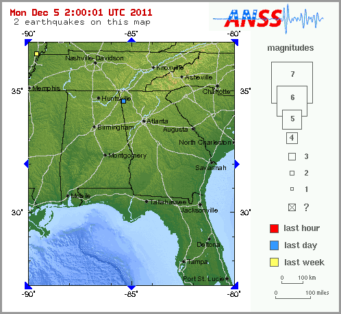
    lindabaker wrote:Magnitude 2.1 - GEORGIA, USA
    2011 December 04 06:55:21 UTC

    Carol, I have been feeling mini quakes for the last two days. Even reported one a coupla days ago. Getting creaks and cracks in the house, too. After reading the post above, I checked USGS, and the one earlier today was this 2.1. This is significant change, because the East just hasn't had quakes before, and I'm as old as dirt. Gonna be 58 in less than two weeks. Quake activity is not I repeat not normal here and I think it is significant, just don't know how, yet.


    Just to get started -

    The Earthquake/Seismic Activity Log - Page 21 Image610


    Emergency Manager's Guide to Earthquakes in Georgia

    Prepared for: Georgia Emergency Management Agency

    February 1999

    Prepared by: Leland Timothy Long

    School of Earth and Atmospheric Sciences

    Georgia Institute of Technology

    Atlanta, Georgia 30332-0340


    Introduction

    When earthquakes are discussed, Georgia is not the first state to be mentioned. Earthquakes in Georgia are rare, particularly when they are compared to the long history of damaging earthquakes which are associated with California's active San Andrea fault zone and other fault zones bounding the tectonic plates of the Earth's crust. Movement of the Earth's crust along these plate boundaries explains most earthquakes. Georgia, like all the other states east of the Rocky Mountains, does not have active faults, and is not on a tectonic plate boundary. However, damaging earthquakes do occur in the interior of tectonic plates and these intraplate earthquakes can be an important consideration for emergency managers.

    Earthquakes are less frequent in the eastern United States than in California. Consequently, fewer small earthquakes occur to remind us of the potential for damage from the less frequent great earthquakes. Never the less the historical record of earthquakes in Georgia (Figure 1) makes it clear that earthquakes and their associated seismic hazards exist. Damages from the great eastern United States earthquakes are largely forgotten because the last great earthquake was over 100 years ago. The 1886 Charleston, S.C., earthquake killed nearly 60 people and devastated the city. Although large earthquakes are less frequent, some seismologist argue that earthquakes cause damage over much larger areas in the eastern United States than earthquakes of similar size in the western United States. Also, the greater population density in the eastern United States increases the damage potential of eastern United States earthquakes over western United States earthquakes. Hence, in Georgia, as in most of the eastern United States, calculations of seismic hazard indicate that large distant earthquakes are likely to cause as much damage in Georgia as earthquakes of any size with epicenters within Georgia. For more details on the seismicity of the United States, see Slemmons et al. (1991).

    READ MORE AT: http://quake.eas.gatech.edu/EMguide/EMguide.htm


    MAP 2.1 2011/12/04 06:55:21 34.607 -85.406 0.7 11 km ( 7 mi) NW of Trion, GA
    MAP 2.0 2011/11/30 19:26:26 36.536 -89.647 6.5 4 km ( 2 mi) NW of Marston, MO

    The Earthquake/Seismic Activity Log - Page 21 Untitl11

    Homeowner's Guide to Earthquake Hazards in Georgia

    By, Leland Timothy Long

    School of Earth and Atmospheric Sciences

    Georgia Institute of Technology

    Atlanta, Georgia 30332-0340

    When earthquake hazards are discussed, Georgia is not the first state to be mentioned. Earthquakes in Georgia are rare compared to the long history of damaging earthquakes which are associated with California's active San Andreas Fault zone. Movements along active faults like the San Andreas explain 85% of the earthquakes in the world. The rest are scattered over areas like Georgia that lack clearly defined active faults. These scattered earthquakes in Georgia the eastern United States have caused significant damage and can be an important consideration for homeowners.

    Because earthquakes are less frequent in the eastern United States than in California, we are not constantly reminded of our seismic hazard by frequent small earthquakes. Never-the-less the historical record of earthquakes in the southeastern United States and Georgia (figure 1) makes it clear that earthquakes and their associated seismic hazards exist. Damages from eastern United States earthquakes are largely forgotten because the last great earthquake was over 100 years ago. The 1886 Charleston, S.C., earthquake killed nearly 60 people and devastated the city. Also, some seismologist argue that while earthquakes in the eastern United States are less frequent, the large earthquakes cause damage over much larger areas and would affect more people than earthquakes of similar size in the western United States. In Georgia, calculations of seismic hazard indicate that large earthquakes outside our borders are as likely to cause damage in Georgia as earthquakes of any size occurring within Georgia.


    The map of Georgia shows the location of all earthquakes that are known to have occurred within 25 km (15 mi.) of Georgia. The earthquakes across northwestern Georgia are part of the Southeastern Tennessee Seismic Zone (STSZ) that extends northeast through Knoxville. The STSZ lies primarily in the Valley and Ridge Province of the Southern Appalachians. Earthquakes in the STSZ are at depths of 14 ± 10 km and do not appear to be correlated with surface geology or near-surface faults. On the basis of seismicity, the STSZ is second only to the New Madrid Seismic Zone in the eastern United States for its size and rate of earthquake production. Earthquakes in the Blue Ridge and Piedmont Provinces occur in clusters with notable concentrations near reservoirs such as Lake Sinclair and Clarks Hill. They may occur any place that has unweathered and slightly fractured granitic rock near the surface. The small Piedmont earthquakes are unique in that they represent movements along shallow fractures that have been weakened, perhaps by penetrating fluids or weathering. Few earthquakes are known to occur in the Coastal Plane Province of South Georgia.

    Small earthquakes are often no more alarming than the many vibrations that originate near or in a home, such as thunder, heavy trucks nearby, sonic booms, objects falling, and unbalanced washing machines. These all have unique characteristics that we learn to recognize through experience. Likewise, we can identify the small magnitude 2.0 or less earthquakes and explosions of a similar size by their unique characteristics. They usually start with a jolt, build rapidly in amplitude within a couple of seconds and then decay. The total felt duration of the typical small Georgia earthquake is usually less than 10 seconds and it sounds like a muffled dynamite explosion. Also, the rattling of loose objects may generate earthquake sounds. The typical small earthquake will be felt by many within 15km (10mi.) so that consultation with neighbors should eliminate most non earthquake sources within the home. The events in northern Georgia are 8 to 15 km deep and do not shake the surface as hard as the Piedmont earthquakes that are typically within 2.0 km of the surface. In the Piedmont, the earthquakes may occur as part of a 2 to 4 month long swarm, such as in the Norris Lake Community swarm of 1993. The time during a swarm is a good opportunity to eliminate hazards that could cause damage and injury during an earthquake, particularly because earthquake swarms are often followed by isolated events as large as the largest event in the swarm.
    http://quake.eas.gatech.edu/Owners/OwnersGuide.htm

    For now...with love from the TroyLigtZone and on the high watch...I shall continue to monitor
    lindabaker
    lindabaker


    Posts : 1385
    Join date : 2010-04-15
    Location : straight ahead

    The Earthquake/Seismic Activity Log - Page 21 Empty Re: The Earthquake/Seismic Activity Log

    Post  lindabaker Sun Dec 04, 2011 8:25 pm

    Thanks, Troy, great info. Hang in there!
    HigherLove
    HigherLove


    Posts : 2357
    Join date : 2011-01-27
    Age : 58

    The Earthquake/Seismic Activity Log - Page 21 Empty Re: The Earthquake/Seismic Activity Log

    Post  HigherLove Sun Dec 04, 2011 8:31 pm

    lindabaker wrote:Thanks, Troy, great info. Hang in there!

    Crazy Happy

    Actually, it has been a great past few days.

    I could say things that would make Horus blush. Ooops.

    I guess forgiveness can be in layers.

    scratch

    Not sure why, but me thinks you are safe in your neck of the woods.

    The Karen
    lindabaker
    lindabaker


    Posts : 1385
    Join date : 2010-04-15
    Location : straight ahead

    The Earthquake/Seismic Activity Log - Page 21 Empty Re: The Earthquake/Seismic Activity Log

    Post  lindabaker Sun Dec 04, 2011 8:38 pm

    Ya, my neck o the woods is going to be just fine! I sometimes wish my Mists friends could see how green and gorgeous those woods really are. The Appalachians are the Misty mountains of the US...Purple mountains with pink skies at sunset and evergreen winters. Amazing place.
    HigherLove
    HigherLove


    Posts : 2357
    Join date : 2011-01-27
    Age : 58

    The Earthquake/Seismic Activity Log - Page 21 Empty Re: The Earthquake/Seismic Activity Log

    Post  HigherLove Sun Dec 04, 2011 9:13 pm

    lindabaker wrote:Ya, my neck o the woods is going to be just fine! I sometimes wish my Mists friends could see how green and gorgeous those woods really are. The Appalachians are the Misty mountains of the US...Purple mountains with pink skies at sunset and evergreen winters. Amazing place.


    The Earthquake/Seismic Activity Log - Page 21 Appala10
    Carol
    Carol
    Admin
    Admin


    Posts : 31733
    Join date : 2010-04-07
    Location : Hawaii

    The Earthquake/Seismic Activity Log - Page 21 Empty Re: The Earthquake/Seismic Activity Log

    Post  Carol Mon Dec 05, 2011 12:00 am

    Woah! Beautiful Troy. TY


    _________________
    What is life?
    It is the flash of a firefly in the night, the breath of a buffalo in the wintertime. It is the little shadow which runs across the grass and loses itself in the sunset.

    With deepest respect ~ Aloha & Mahalo, Carol
    Carol
    Carol
    Admin
    Admin


    Posts : 31733
    Join date : 2010-04-07
    Location : Hawaii

    The Earthquake/Seismic Activity Log - Page 21 Empty Re: The Earthquake/Seismic Activity Log

    Post  Carol Tue Dec 06, 2011 2:15 pm

    The Earthquake/Seismic Activity Log - Page 21 750746-news
    5.4-magnitude quake rattles northern WA, near Exmouth
    December 6, 2011 – AUSTRALIA – A 5.1 magnitude earthquake has struck off Western Australia’s Gascoyne coast according to the US Geological Survey. The U.S. Geological Survey said the quake struck near the Muiron Islands nature reserve, north-east of Exmouth, at a depth of 9.8 kilometers, just after 3am (WST). Geoscience Australia had the quake at 5.4 at the time of writing. There were no immediate reports of injury or damage, and no tsunami warnings. The Seven Network reported the quake was felt up to 270km away. –News


    _________________
    What is life?
    It is the flash of a firefly in the night, the breath of a buffalo in the wintertime. It is the little shadow which runs across the grass and loses itself in the sunset.

    With deepest respect ~ Aloha & Mahalo, Carol
    HigherLove
    HigherLove


    Posts : 2357
    Join date : 2011-01-27
    Age : 58

    The Earthquake/Seismic Activity Log - Page 21 Empty Re: The Earthquake/Seismic Activity Log

    Post  HigherLove Tue Dec 06, 2011 11:49 pm

    MAP 5.0 2011/12/07 05:13:17 17.663 -93.980 202.6 VERACRUZ, MEXICO
    MAP 5.3 2011/12/07 04:08:36 -20.306 -174.268 29.3 TONGA
    MAP 3.4 2011/12/07 03:43:22 19.328 -155.129 6.0 ISLAND OF HAWAII, HAWAII
    MAP 2.9 2011/12/07 01:43:39 65.140 -151.817 5.3 NORTHERN ALASKA

    Magnitude 5.0
    Date-Time

    Wednesday, December 07, 2011 at 05:13:17 UTC
    Tuesday, December 06, 2011 at 11:13:17 PM at epicenter
    Time of Earthquake in other Time Zones

    Location 17.663°N, 93.980°W
    Depth 202.6 km (125.9 miles)
    Region VERACRUZ, MEXICO
    Distances 71 km (44 miles) SE of Coatzacoalcos, Veracruz, Mexico
    117 km (72 miles) WSW of Villahermosa, Tabasco, Mexico
    136 km (84 miles) NW of Tuxtla Gutierrez, Chiapas, Mexico
    581 km (361 miles) ESE of MEXICO CITY, D.F., Mexico
    Location Uncertainty horizontal +/- 17.9 km (11.1 miles); depth +/- 9.6 km (6.0 miles)
    Parameters NST=200, Nph=204, Dmin=249.4 km, Rmss=1.04 sec, Gp=130°,
    M-type=body wave magnitude (Mb), Version=7
    Source

    Magnitude: USGS NEIC (WDCS-D)
    Location: USGS NEIC (WDCS-D)

    Event ID usc00073cu
    HigherLove
    HigherLove


    Posts : 2357
    Join date : 2011-01-27
    Age : 58

    The Earthquake/Seismic Activity Log - Page 21 Empty Re: The Earthquake/Seismic Activity Log

    Post  HigherLove Wed Dec 07, 2011 10:00 am

    Magnitude
    5.7
    Date-Time
    Wednesday, December 07, 2011 at 13:38:26 UTC
    Wednesday, December 07, 2011 at 10:38:26 PM at epicenter
    Time of Earthquake in other Time Zones
    Location
    1.463°S, 126.499°E
    Depth
    17 km (10.6 miles)
    Region
    KEPULAUAN SULA, INDONESIA
    Distances
    266 km (165 miles) SSW of Ternate, Moluccas, Indonesia
    311 km (193 miles) NW of Ambon, Moluccas, Indonesia
    792 km (492 miles) N of DILI, Timor-Leste
    1309 km (813 miles) NNW of DARWIN, Northern Territory, Australia
    Location Uncertainty
    horizontal +/- 13.6 km (8.5 miles); depth +/- 4.5 km (2.8 miles)
    Parameters
    NST=281, Nph=284, Dmin=417.4 km, Rmss=0.89 sec, Gp= 29°,
    M-type=teleseismic moment magnitude (Mw), Version=A
    Source
    Magnitude: USGS NEIC (WDCS-D)
    Location: USGS NEIC (WDCS-D)
    Event ID
    usc00073gf

    The Earthquake/Seismic Activity Log - Page 21 125_0-10

    HigherLove
    HigherLove


    Posts : 2357
    Join date : 2011-01-27
    Age : 58

    The Earthquake/Seismic Activity Log - Page 21 Empty Re: The Earthquake/Seismic Activity Log

    Post  HigherLove Wed Dec 07, 2011 6:30 pm

    Magnitude 5.9
    Date-Time

    Wednesday, December 07, 2011 at 22:23:07 UTC
    Wednesday, December 07, 2011 at 07:23:07 PM at epicenter
    Time of Earthquake in other Time Zones

    Location 27.866°S, 70.923°W
    Depth 5 km (3.1 miles)
    Region ATACAMA, CHILE
    Distances 79 km (49 miles) NNW of Vallenar, Atacama, Chile
    80 km (49 miles) SW of Copiapo, Atacama, Chile
    234 km (145 miles) N of Coquimbo, Coquimbo, Chile
    619 km (384 miles) N of SANTIAGO, Region Metropolitana, Chile
    Location Uncertainty horizontal +/- 17.8 km (11.1 miles); depth +/- 2.8 km (1.7 miles)
    Parameters NST=338, Nph=339, Dmin=129.1 km, Rmss=0.94 sec, Gp= 61°,
    M-type=regional moment magnitude (Mw), Version=9
    Source

    Magnitude: USGS NEIC (WDCS-D)
    Location: USGS NEIC (WDCS-D)

    Event ID usc00073nc

    MAP 5.9 2011/12/07 22:23:08 -27.866 -70.923 5.0 ATACAMA, CHILE
    MAP 4.6 2011/12/07 16:21:55 -28.553 -71.221 24.8 ATACAMA, CHILE


    Earthquake overview : The (extremely) shallow earthquake (USGS data) occurred along the northern Chile coast. Only a few villages are located in the direct epicenter area and are at risk during this earthquake. Locations like Huasco, Copiapo and Caldera will have felt the shaking. The difference in epicenter location and hypocenter leads to a theoretical difference in intensity from max. V (Chile) to VIII (USGS)
    Thanks to Carlos Robles who joined us in searching information.

    http://earthquake-report.com/2011/12/07/dangerous-shallow-earthquake-below-the-northern-chile-coast/
    HigherLove
    HigherLove


    Posts : 2357
    Join date : 2011-01-27
    Age : 58

    The Earthquake/Seismic Activity Log - Page 21 Empty Re: The Earthquake/Seismic Activity Log

    Post  HigherLove Thu Dec 08, 2011 8:41 am

    MAP 4.6 2011/12/08 14:03:04 13.308 -89.960 89.6 OFFSHORE EL SALVADOR
    MAP 4.8 2011/12/08 13:24:29 28.321 142.644 10.1 BONIN ISLANDS, JAPAN REGION
    MAP 3.5 2011/12/08 11:45:50 68.036 -159.315 35.2 NORTHERN ALASKA
    MAP 2.5 2011/12/08 09:59:16 38.800 -122.813 3.2 NORTHERN CALIFORNIA
    MAP 3.3 2011/12/08 09:57:54 38.801 -122.814 3.5 NORTHERN CALIFORNIA
    MAP 5.0 2011/12/08 08:54:46 37.988 -30.841 10.0 AZORES ISLANDS, PORTUGAL
    MAP 2.8 2011/12/08 06:33:48 33.911 -118.345 17.7 GREATER LOS ANGELES AREA, CALIFORNIA
    MAP 4.0 2011/12/08 05:19:10 40.466 -125.727 2.6 OFF THE COAST OF NORTHERN CALIFORNIA
    MAP 4.6 2011/12/08 04:13:19 47.007 152.716 72.5 KURIL ISLANDS
    MAP 5.0 2011/12/08 03:17:49 28.657 142.815 35.0 BONIN ISLANDS, JAPAN REGION
    MAP 4.6 2011/12/08 01:13:23 -27.907 -71.197 20.0 OFFSHORE ATACAMA, CHILE
    MAP 4.5 2011/12/08 00:49:17 -6.928 126.828 385.5 BANDA SEA
    MAP 3.2 2011/12/08 00:08:57 57.272 -155.974 107.3 ALASKA PENINSULA

    Magnitude 4.0
    Date-Time

    Thursday, December 08, 2011 at 05:19:09 UTC
    Wednesday, December 07, 2011 at 09:19:09 PM at epicenter
    Time of Earthquake in other Time Zones

    Location 40.466°N, 125.727°W
    Depth 2.6 km (1.6 miles) (poorly constrained)
    Region OFF THE COAST OF NORTHERN CALIFORNIA
    Distances

    123 km (76 miles) W (278°) from Petrolia, CA
    124 km (77 miles) W (265°) from Ferndale, CA
    132 km (82 miles) WSW (258°) from Humboldt Hill, CA
    137 km (85 miles) WSW (255°) from Eureka, CA
    413 km (257 miles) NW (317°) from San Francisco City Hall, CA

    Location Uncertainty horizontal +/- 4.3 km (2.7 miles); depth +/- 37.7 km (23.4 miles)
    Parameters Nph= 92, Dmin=118 km, Rmss=0.45 sec, Gp=266°,
    M-type=regional moment magnitude (Mw), Version=6
    Source

    California Integrated Seismic Net:
    USGS Caltech CGS UCB UCSD UNR

    Event ID nc71693701

    The Earthquake/Seismic Activity Log - Page 21 Untitl36


    HigherLove
    HigherLove


    Posts : 2357
    Join date : 2011-01-27
    Age : 58

    The Earthquake/Seismic Activity Log - Page 21 Empty Re: The Earthquake/Seismic Activity Log

    Post  HigherLove Thu Dec 08, 2011 9:08 am

    This one in the Geysers just made the morning news. I did not feel it, but apparently people to my SW did feel it (Sonoma County):

    Magnitude 3.3
    Date-Time

    Thursday, December 08, 2011 at 09:57:54 UTC
    Thursday, December 08, 2011 at 01:57:54 AM at epicenter
    Time of Earthquake in other Time Zones

    Location 38.801°N, 122.814°W
    Depth 3.5 km (2.2 miles)
    Region NORTHERN CALIFORNIA
    Distances

    1 km (0 miles) WNW (296°) from The Geysers, CA
    9 km (6 miles) WSW (245°) from Cobb, CA
    11 km (7 miles) WNW (285°) from Anderson Springs, CA
    18 km (11 miles) E (89°) from Cloverdale, CA
    40 km (25 miles) NNW (346°) from Santa Rosa, CA
    119 km (74 miles) NNW (343°) from San Francisco City Hall, CA

    Location Uncertainty horizontal +/- 0.1 km (0.1 miles); depth +/- 0.2 km (0.1 miles)
    Parameters Nph= 71, Dmin=2 km, Rmss=0.07 sec, Gp= 22°,
    M-type=local magnitude (ML), Version=3
    Source

    California Integrated Seismic Net:
    USGS Caltech CGS UCB UCSD UNR

    Event ID nc71693786


    The Earthquake/Seismic Activity Log - Page 21 123-3910
    Carol
    Carol
    Admin
    Admin


    Posts : 31733
    Join date : 2010-04-07
    Location : Hawaii

    The Earthquake/Seismic Activity Log - Page 21 Empty Re: The Earthquake/Seismic Activity Log

    Post  Carol Fri Dec 09, 2011 10:15 am

    The Earthquake/Seismic Activity Log - Page 21 Usc00073nc_ciim
    6.1 magnitude earthquake strikes coastline of Atacama Chile
    December 8, 2011 – CHILE - A shallow 6.1 magnitude earthquake struck near the coastline of the Atacama, Chile at 22:23:09 GMT at a depth of about 15 km, according to the USGS. There have been no reports of injuries. The epicenter of the earthquake was 619 km (384 miles) N of Santiago, Region Metropolitana, Chile. The earthquake was preceded by a 4.6 magnitude foreshock.


    _________________
    What is life?
    It is the flash of a firefly in the night, the breath of a buffalo in the wintertime. It is the little shadow which runs across the grass and loses itself in the sunset.

    With deepest respect ~ Aloha & Mahalo, Carol

      Current date/time is Mon May 06, 2024 7:25 pm