tMoA

Would you like to react to this message? Create an account in a few clicks or log in to continue.
tMoA

~ The only Home on the Web You'll ever need ~

+21
Aquaries1111
giovonni
arvan33
Floyd
lawlessline
JesterTerrestrial
THEeXchanger
newel
Brook
greybeard
Mercuriel
Sanicle
devakas
hobbit
mudra
burgundia
lindabaker
LeeEllisMusic
MargueriteBee
Carol
HigherLove
25 posters

    The Earthquake/Seismic Activity Log

    Carol
    Carol
    Admin
    Admin


    Posts : 31699
    Join date : 2010-04-07
    Location : Hawaii

    The Earthquake/Seismic Activity Log - Page 40 Empty Re: The Earthquake/Seismic Activity Log

    Post  Carol Sat Apr 20, 2013 9:14 am

    The Earthquake/Seismic Activity Log - Page 40 _67127627_67127626
    http://www.bbc.co.uk/news/world-22228225
    China quake kills scores in rural Sichuan
    A powerful earthquake has killed more than 150 people and injured several thousand in China's rural south west, officials say. The 6.6-magnitude tremor sent people fleeing from buildings across Sichuan province, which was devastated by a massive quake five years ago. Villages close to the epicentre in Lushan county were left in ruins. Thousands of troops have been sent to Sichuan, and Premier Li Keqiang is also travelling to the area. "The current most urgent issue is grasping the first 24 hours since the quake's occurrence, the golden time for saving lives," Mr Li was quoted as saying by state news agency Xinhua. Rescuers have been able to pull some bodies and survivors from the rubble of devastated villages. But recovery efforts have been hampered by aftershocks and landslides. Power and water supplies have been knocked out in Lushan county, and some roads are impassable.

    'Everything collapsed'


    _________________
    What is life?
    It is the flash of a firefly in the night, the breath of a buffalo in the wintertime. It is the little shadow which runs across the grass and loses itself in the sunset.

    With deepest respect ~ Aloha & Mahalo, Carol
    Carol
    Carol
    Admin
    Admin


    Posts : 31699
    Join date : 2010-04-07
    Location : Hawaii

    The Earthquake/Seismic Activity Log - Page 40 Empty Re: The Earthquake/Seismic Activity Log

    Post  Carol Sun Apr 21, 2013 9:57 pm

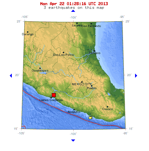
    The Earthquake/Seismic Activity Log - Page 40 Mexico-4-22
    Quake Causes Buildings to Sway in Mexico City
    MEXICO CITY April 22, 2013 (AP) - A 5.9-magnitude earthquake struck in the Mexican state of Michoacan on Sunday night, causing buildings to sway 200 miles away in Mexico City. Some people evacuated buildings in the capital, but there were no immediate reports of damage or injuries. State officials in Michoacan also said they had no reports of casualties or damage. The U.S. Geological Survey said the quake's epicenter was about 23 miles (38 kilometers) northeast of the Pacific port of Lazaro Cardenas. That is about 202 miles (327 kilometers) west-southwest of Mexico City. The USGS said its preliminary reading of the quake gave it a magnitude of 5.9. Mexico's National Seismological Service put the magnitude at 5.8.The tremor occurred 45 miles (73 kilometers) below the Earth's surface, the USGS said. The energy of a deep earthquake dissipates more than that of a shallow quake and generally causes less damage.

    April 22, 2013 – MEXICO - A magnitude 5.9 earthquake struck western Mexico on Sunday, shaking buildings in the capital, but there were no reports of significant damage or injuries, officials said. The quake, initially reported as a magnitude 6.2 off the coast, was centered 33 km (20 miles) northwest of La Union, on the border between Guerrero and Michoacan states, close to the Pacific coast, the U.S. Geological Survey said. State oil monopoly Pemex said shortly after the quake that the power supply to its Tula refinery was interrupted. Not long after, it reported electricity was coming back on line again. Pemex said it was unclear if the tremor had caused the break in energy supply at the Tula refinery, Mexico’s second biggest. It has a production capacity of 315,000 barrels per day. A Pemex official could not say whether production had been affected, but added that any loss would be made up. The quake was felt in Mexico City, about 325 km (200 miles) away from La Union. Buildings shook and residents briefly ran outdoors, but most returned inside shortly afterwards. Several senior Mexican officials, including Interior Minister Miguel Angel Osorio Chong, said via Twitter there were no immediate reports of injuries or significant damage. –Reuters


    Last edited by Carol on Wed Apr 24, 2013 10:12 am; edited 1 time in total


    _________________
    What is life?
    It is the flash of a firefly in the night, the breath of a buffalo in the wintertime. It is the little shadow which runs across the grass and loses itself in the sunset.

    With deepest respect ~ Aloha & Mahalo, Carol
    Carol
    Carol
    Admin
    Admin


    Posts : 31699
    Join date : 2010-04-07
    Location : Hawaii

    The Earthquake/Seismic Activity Log - Page 40 Empty Re: The Earthquake/Seismic Activity Log

    Post  Carol Wed Apr 24, 2013 10:03 am

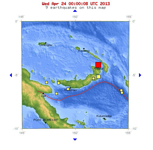
    A strong earthquake has struck the South Pacific island nation of Papua New Guinea. There are no immediate reports of damage or injuries and no tsunami alert has been issued. The U.S. Geological Survey says the magnitude-6.4 quake struck Wednesday at a depth of 17 kilometers (10 miles). The epicenter is about 30 kilometers (18 miles) north of Rabaul on Papua New Guinea's island of New Britain. The Pacific Tsunami Warning Center did not issue a tsunami alert and the Geophysical Observatory in the capital, Port Moresby, had not received any reports of damage or unusual wave activity.


    _________________
    What is life?
    It is the flash of a firefly in the night, the breath of a buffalo in the wintertime. It is the little shadow which runs across the grass and loses itself in the sunset.

    With deepest respect ~ Aloha & Mahalo, Carol
    Carol
    Carol
    Admin
    Admin


    Posts : 31699
    Join date : 2010-04-07
    Location : Hawaii

    The Earthquake/Seismic Activity Log - Page 40 Empty Re: The Earthquake/Seismic Activity Log

    Post  Carol Wed Apr 24, 2013 10:06 am

    The Earthquake/Seismic Activity Log - Page 40 Map-indian-ocean-region-indo-australian-plate-lg
    Planet has unusual period of silence between large earthquakes
    April 24, 2013 – GEOLOGY - In the global aftershock zone that followed the major April 2012 Indian Ocean earthquake, seismologists noticed an unusual pattern. The magnitude (M) 8.6 earthquake, a strike-slip event at intra-oceanic tectonic plates, caused global seismic rates of M=4.5 to rise for several days, even at distances thousands of kilometers from the main-shock site. However, the rate of M=6.5 seismic activity subsequently dropped to zero for the next 95 days. This period of quiet, without a large quake, has been a rare event in the past century. So why did this period of quiet occur? In his research presentation, Fred Pollitz of the U.S. Geological Survey suggests that the Indian Ocean earthquake caused short-term dynamic stressing of a global faulting system. Across the planet, there are faults that are “close to failure” and ready to rupture. It may be, suggests Pollitz and his colleagues, that a large quake encourages short-term triggering of these close-to-failure faults but also relieves some of the stress that has built up along these faults. Large magnitude events would not occur until tectonic movement loads stress back on to the faults at the ready-to-fail levels they reached before the main shock. Using a statistical model of global seismicity, Pollitz and his colleagues show that a transient seismic perturbation of the size of the April 2012 global aftershock would inhibit rupture in 88 percent of their possible M=6.5 earthquake fault sources over the next 95 days, regardless of how close they were to failure beforehand. -SD


    The Earthquake/Seismic Activity Log - Page 40 Chinas-earthquake-leaves--016
    Death toll rises to 193 from China’s 6.6 magnitude earthquake: 1.4 million houses damaged
    April 23, 2013 – CHINA – The death toll in China’s earthquake rose to 193 today with over 12,000 injured in the catastrophic disaster, as rescue work was hampered by rain and 3,000 aftershocks. In the latest figures released here, Chinese officials said 193 people had been killed and 23 people have to be accounted for. Over 1.40 million houses were damaged by the quake affecting the lives of over two million people in the Lushan County of the Sichuan province which was struck by 7.0 magnitude quake on Saturday. The places recorded over 3000 aftershocks measuring up to 5.4 in magnitude, making the rescue work more difficult. Also new threats and hazards began to loom large today as rescue and relief efforts entered a fourth day. Rain began lashing the area, hampering relief work and posing threats such as rain-triggered landslides and possible outbreaks of disease. According to the National Meteorological Center, moderate rain will linger in the quake-hit region over the next few days, adding to difficulties in carrying out relief work. “Such weather is hampering our rescue and relief work, and it’s risky to operate large machines under such conditions,” Zhang Yefu, an engineer who is leading a team to build makeshift shelters in Lushan county, was quoted by the state-run Xinhua news agency as saying. Sanitation conditions in the region are far from satisfactory as there is not enough clean water and locals are in need of toilets. “People in the town are drinking water from wells or mountain springs, but we have no idea if it is clean enough or adequate,” said 43-year-old Yang Yumei, from the township of Lingguan in Baoxing which is one of the counties that was worst-hit by the quake. Zhang Zuyun, deputy head of Sichuan Provincial Health Department, said providing safe and clean drinking water to locals is a problem, noting that some people are suffering from diarrhea. Zhang said the local health authority is trying to send a water quality testing machine to the town. –Zee News


    _________________
    What is life?
    It is the flash of a firefly in the night, the breath of a buffalo in the wintertime. It is the little shadow which runs across the grass and loses itself in the sunset.

    With deepest respect ~ Aloha & Mahalo, Carol
    Carol
    Carol
    Admin
    Admin


    Posts : 31699
    Join date : 2010-04-07
    Location : Hawaii

    The Earthquake/Seismic Activity Log - Page 40 Empty Re: The Earthquake/Seismic Activity Log

    Post  Carol Sun May 12, 2013 9:31 pm

    Iran rattled by 6.2 quake, aftershocks continue
    The US Geological Survey (USGS) registered the quake at 0208 GMT, with an epicenter 85 kilometers (52 miles) southeast of the town of Minab, located in the southern Hormuzgan Province off the Strait of Hormuz.

    6.5 Tonga Island


    DATE LAT LON MAG DEPTH
    km REGION
    12-MAY-2013 23:05:28 21.91 143.81 5.1 176 MARIANA ISLANDS REGION
    12-MAY-2013 22:42:45 44.03 147.81 5.6 53 KURIL ISLANDS

    12-MAY-2013 22:40:32 29.53 52.70 4.4 14 SOUTHERN IRAN
    12-MAY-2013 20:06:46 52.51 -171.94 5.7 45 FOX ISLANDS, ALEUTIAN ISLANDS
    12-MAY-2013 19:06:11 -7.63 128.01 4.4 171 BANDA SEA
    12-MAY-2013 17:58:58 -6.51 128.07 4.6 318 BANDA SEA
    12-MAY-2013 17:49:34 1.18 -101.29 4.7 10 GALAPAGOS TRIPLE JUNCTION REGION
    12-MAY-2013 13:14:28 -3.11 -77.59 4.6 24 PERU-ECUADOR BORDER REGION
    12-MAY-2013 12:59:11 -26.18 -69.22 5.6 8 NORTHERN CHILE
    12-MAY-2013 12:51:53 -21.01 -68.55 5.3 131 CHILE-BOLIVIA BORDER REGION

    12-MAY-2013 12:48:08 26.73 57.81 4.4 25 SOUTHERN IRAN
    12-MAY-2013 11:58:46 -22.08 170.26 4.8 18 LOYALTY ISLANDS REGION
    12-MAY-2013 11:56:39 27.40 57.37 4.1 10 SOUTHERN IRAN
    12-MAY-2013 10:54:50 26.79 57.74 5.4 26 SOUTHERN IRAN
    12-MAY-2013 10:19:31 39.55 73.03 4.8 41 TAJIKISTAN-XINJIANG BORDER REG.
    12-MAY-2013 09:07:25 -6.46 154.23 4.8 48 SOLOMON ISLANDS
    12-MAY-2013 09:02:26 26.64 57.70 4.5 26 SOUTHERN IRAN
    12-MAY-2013 09:00:39 46.64 152.65 4.8 69 KURIL ISLANDS
    12-MAY-2013 08:48:32 -6.40 154.27 4.8 45 SOLOMON ISLANDS
    12-MAY-2013 07:30:03 13.50 -91.38 5.2 37 NEAR COAST OF GUATEMALA
    12-MAY-2013 06:34:09 58.73 -153.84 4.4 96 KODIAK ISLAND REGION
    12-MAY-2013 06:13:14 26.52 57.96 4.2 24 SOUTHERN IRAN
    12-MAY-2013 04:23:06 26.86 57.71 4.4 20 SOUTHERN IRAN
    12-MAY-2013 02:50:02 26.74 57.75 4.2 19 SOUTHERN IRAN
    12-MAY-2013 02:07:03 13.69 -91.24 4.3 62 NEAR COAST OF GUATEMALA
    12-MAY-2013 01:08:22 26.47 57.75 4.5 20 SOUTHERN IRAN
    12-MAY-2013 01:06:27 26.84 57.85 4.4 10 SOUTHERN IRAN
    12-MAY-2013 00:07:02 26.70 57.81 5.5 15 SOUTHERN IRAN
    11-MAY-2013 22:28:09 26.69 57.52 4.6 10 SOUTHERN IRAN
    11-MAY-2013 22:23:04 26.72 57.76 4.9 10 SOUTHERN IRAN
    11-MAY-2013 21:51:32 26.75 57.68 4.9 10 SOUTHERN IRAN
    11-MAY-2013 20:46:56 -17.94 -175.07 6.5 205 TONGA ISLANDS
    11-MAY-2013 19:38:27 -15.76 -71.53 4.3 158 SOUTHERN PERU
    11-MAY-2013 19:31:45 24.75 123.25 4.5 29 SOUTHWESTERN RYUKYU ISLANDS
    11-MAY-2013 18:06:14 26.65 57.90 4.7 24 SOUTHERN IRAN
    11-MAY-2013 15:39:24 -26.16 -69.34 5.4 15 NORTHERN CHILE
    11-MAY-2013 14:36:35 -3.76 129.73 4.5 40 SERAM, INDONESIA
    11-MAY-2013 14:34:23 36.18 70.86 4.4 103 HINDU KUSH REGION, AFGHANISTAN
    11-MAY-2013 12:15:43 37.69 143.95 4.5 10 OFF EAST COAST OF HONSHU, JAPAN
    11-MAY-2013 10:25:36 26.73 57.66 4.3 27 SOUTHERN IRAN
    11-MAY-2013 10:03:05 26.66 57.77 4.6 25 SOUTHERN IRAN
    11-MAY-2013 08:42:38 26.75 57.78 5.0 22 SOUTHERN IRAN
    11-MAY-2013 07:47:57 11.60 -87.37 4.2 35 NEAR COAST OF NICARAGUA
    11-MAY-2013 05:59:39 26.81 58.06 4.3 10 SOUTHERN IRAN
    11-MAY-2013 05:45:33 26.55 57.70 4.3 25 SOUTHERN IRAN
    11-MAY-2013 05:34:16 26.62 57.71 4.4 25 SOUTHERN IRAN
    11-MAY-2013 05:10:05 30.11 51.64 4.0 11 NORTHERN IRAN
    11-MAY-2013 04:42:39 32.82 12.44 4.7 15 NEAR COAST OF LIBYA
    11-MAY-2013 04:37:48 -18.54 -173.66 4.7 43 TONGA ISLANDS
    11-MAY-2013 04:09:32 26.82 57.79 4.7 25 SOUTHERN IRAN
    11-MAY-2013 03:58:18 26.92 57.53 4.4 30 SOUTHERN IRAN
    11-MAY-2013 03:44:40 44.34 148.26 4.6 108 KURIL ISLANDS
    11-MAY-2013 03:41:31 26.79 57.94 5.0 30 SOUTHERN IRAN
    11-MAY-2013 03:17:24 26.58 57.58 4.7 26 SOUTHERN IRAN
    11-MAY-2013 03:09:53 26.68 57.94 5.5 27 SOUTHERN IRAN
    11-MAY-2013 03:03:30 26.77 57.77 4.8 24 SOUTHERN IRAN
    11-MAY-2013 02:50:02 26.64 57.86 4.6 26 SOUTHERN IRAN
    11-MAY-2013 02:32:45 26.81 57.80 4.5 26 SOUTHERN IRAN
    11-MAY-2013 02:29:46 26.75 57.95 4.6 35 SOUTHERN IRAN
    11-MAY-2013 02:19:12 -15.93 -72.33 4.7 102 SOUTHERN PERU
    11-MAY-2013 02:08:11 26.78 57.88 6.2 14 SOUTHERN IRAN
    11-MAY-2013 01:07:21 30.24 102.97 4.4 12 SICHUAN, CHINA
    11-MAY-2013 00:59:57 51.96 -171.01 4.2 38 FOX ISLANDS, ALEUTIAN ISLANDS
    11-MAY-2013 00:50:40 30.31 102.95 4.6 18 SICHUAN, CHINA


    _________________
    What is life?
    It is the flash of a firefly in the night, the breath of a buffalo in the wintertime. It is the little shadow which runs across the grass and loses itself in the sunset.

    With deepest respect ~ Aloha & Mahalo, Carol
    Carol
    Carol
    Admin
    Admin


    Posts : 31699
    Join date : 2010-04-07
    Location : Hawaii

    The Earthquake/Seismic Activity Log - Page 40 Empty Re: The Earthquake/Seismic Activity Log

    Post  Carol Tue May 14, 2013 2:16 pm

    The Earthquake/Seismic Activity Log - Page 40 99eca-paganquake02
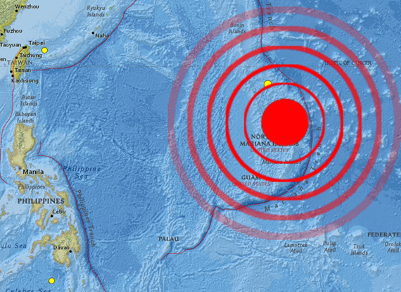
    Deep 6.8 magnitude earthquake strikes Northern Mariana Islands
    May 14, 2013 – PACIFIC - A deep 7.0-magnitude earthquake struck near the Northern Mariana Islands in the western Pacific on Tuesday, the US Geological Survey said, but no tsunami warning was issued. The earthquake was later downgraded to a 6.8 by the USGS. The quake hit 42 kilometers (26 miles) west of Agrihan and 395 kilometers north of the main island Saipan, but it was at a depth of 603 kilometers and seismologists said it was too deep to cause any impact. “Obviously people may get a small shake but there’s hardly any population around there,” Geoscience Australia seismologist David Jepson told AFP. “There’s definitely no tsunami and it was too deep and too far away from anywhere to have caused any damage.” The earthquake was preceded by a 5.1 magnitude foreshock. A self-governing commonwealth of the United States since 1976, the Northern Marianas consists of 15 islands, with more than 90 percent of the population of 54,000 living on Saipan. Only four other islands are populated. –Hindustan


    _________________
    What is life?
    It is the flash of a firefly in the night, the breath of a buffalo in the wintertime. It is the little shadow which runs across the grass and loses itself in the sunset.

    With deepest respect ~ Aloha & Mahalo, Carol
    Carol
    Carol
    Admin
    Admin


    Posts : 31699
    Join date : 2010-04-07
    Location : Hawaii

    The Earthquake/Seismic Activity Log - Page 40 Empty Re: The Earthquake/Seismic Activity Log

    Post  Carol Wed May 15, 2013 12:10 pm

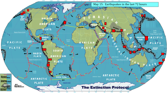
    The Earthquake/Seismic Activity Log - Page 40 May-15-the-extinction-protocol
    Planet reeling from a swarm of earthquakes over last 72 hours
    May 15, 2013 – GEOLOGY – A flurry of earthquakes continues across the planet over the past 72 hours, showing few signs of abatement. Seismic tension continues to build across the Pacific Plate, the Cocos plate (Central America), and the Nazca plate, near South America. Tectonic plate agitation appears to be increasing, along with volcanic pressures under many of the world’s major volcanoes. -TEP

    55th volcano erupts in Alaska: Scientists say small lava flows have been detected on two restless volcanoes in Alaska. The Alaska Volcano Observatory says satellite images Tuesday show the lava partly down a flank of Pavlof Volcano in a low-level eruption 625 miles southwest of Anchorage. Geophysicist Dave Schneider says minor steam and ash emissions are visible from the community of Cold Bay 37 miles away. Pavlof is the second Alaska volcano to erupt this month. Cleveland Volcano, on an uninhabited island in the Aleutian Islands, experienced a low-level eruption in early May. The observatory says analysis of satellite imagery shows a lava flow partly down a flank of the volcano. Ash plumes can be an aviation hazard, but no ash clouds have been detected from Cleveland Volcano in the past week. –Yahoo News


    _________________
    What is life?
    It is the flash of a firefly in the night, the breath of a buffalo in the wintertime. It is the little shadow which runs across the grass and loses itself in the sunset.

    With deepest respect ~ Aloha & Mahalo, Carol
    Carol
    Carol
    Admin
    Admin


    Posts : 31699
    Join date : 2010-04-07
    Location : Hawaii

    The Earthquake/Seismic Activity Log - Page 40 Empty Re: The Earthquake/Seismic Activity Log

    Post  Carol Wed May 15, 2013 12:24 pm

    The Earthquake/Seismic Activity Log - Page 40 Indian-ocean-plate-earthquake-120926
    The break-up of the Indo-Australian Plate, which was hastened by 8.6 and 8.2
    earthquakes in 2012 could further increase seismic volatility in the region.

    New study warns 9.0 magnitude earthquakes could strike off coasts of Pakistan, Iran, and India
    May 15, 2013 – INDIA - India’s west coast is far more vulnerable to monster earthquakes and tsunamis than believed till now, scientists have said in dramatic new findings that could force a rethink on the country’s preparedness for natural disasters on a coastline that hosts its biggest nuclear reactor. Undersea earthquakes as strong as the 2004 Sumatra temblor that spawned a tsunami killing over 220,000 could also strike under the Arabian Sea, off the coast of Pakistan and Iran, striking those countries, India, Oman and further inland, a team of British and Canadian scientists has said. India’s Arabian Sea coast is home to the 1400 MW Tarapur Power Station near Mumbai, India’s largest operational nuclear plant that in 2011 was also identified by a government expert panel as the least prepared of the country’s atomic power complexes to handle a scenario like the one at Fukushima in Japan in 2011. The country is also in the process of setting up a 10,000 MW nuclear power complex at Jaitapur that has faced local opposition. But though the subduction zone – where tectonic plates meet – to India’s west, near Makran along the Pakistan-Iran border is closer to India than the one to the east that was the epicentre of the 2004 tremors, the Arabian Sea has long been considered less vulnerable to large earthquakes and tsunamis. Unlike the Pacific Ocean and the eastern Indian Ocean, where giant undersea earthquakes are common, the Makran region has been largely quiet after a 7.3 magnitude tremor in 1947. That view may be dangerously complacent and incorrect, scientists at the University of Southampton, UK and the Canadian government’s Pacific Geoscience Centre have suggested in their research, published in reputed journal Geophysical Research Letters. “The Makran subduction zone is potentially capable of producing major earthquakes, up to magnitude 8.7-9.2,” Gemma Smith, lead author and PhD student at Southampton said. “Past assumptions may have significantly underestimated the earthquake and tsunami hazard in this region.” In 2004, an earthquake of magnitude 9 off the Indonesian coast triggered giant tsunami waves that reached as far as Africa, killing over 12,000 and forcing over 640,000 Indians to flee their homes according to government figures. The tsunami waves devastated Indonesia, swept away locals and tourists on the pristine beaches of Thailand and Sri Lanka, and claimed lives as far away as Yemen, Somalia and South Africa. The Madras Atomic Power Station in Kalpakkam, on India’s eastern, Tamil Nadu coast, was partially flooded. After the 2011 earthquake off the coast of Japan and the resulting tsunami that led to the Fukushima nuclear disaster, the worst nuclear incident since Chernobyl in 1986, India’s sole nuclear operator, the Nuclear Power Corporation of India Limited (NPCIL) conducted a safety audit of the country’s nuclear facilities. The experts on the probe panel concluded that 18 of India’s 20 working nuclear reactors were capable of handling a Fukushima-like crisis – power outage stopping the plant’s cooling facilities and simultaneous flooding from sea water. But the team found two reactors at Tarapur – first introduced in 1963 – that work on the same principles as the Fukushima reactors vulnerable to tsunami waves and large tremors. –Hindustan Times


    _________________
    What is life?
    It is the flash of a firefly in the night, the breath of a buffalo in the wintertime. It is the little shadow which runs across the grass and loses itself in the sunset.

    With deepest respect ~ Aloha & Mahalo, Carol
    Carol
    Carol
    Admin
    Admin


    Posts : 31699
    Join date : 2010-04-07
    Location : Hawaii

    The Earthquake/Seismic Activity Log - Page 40 Empty Re: The Earthquake/Seismic Activity Log

    Post  Carol Wed May 15, 2013 12:25 pm

    The Earthquake/Seismic Activity Log - Page 40 Images?q=tbn:ANd9GcRCwQX4GDhx0ViLrJi_ruYxb825On8C_5yqoG-tBE5B57_1Z0hx
    Swarm of tremors continue to rattle Kashmir region- 1 dead
    May 15, 2013 - KASHMIR – Fresh tremors on Wednesday shook Bhaderwah belt of Doda district where a panic-stricken elderly woman died of a heart attack while fleeing from her home. 61-year-old Naseema Begum suffered the cardiac arrest while running out of her house during tremors this morning in Soti village of the district, officials said. She was taken to a hospital, where she was declared as brought dead, they said. Three moderate intensity earthquakes and five aftershocks shook Bhaderwah valley and adjoining areas in Doda-Kishtwar belt of Jammu and Kashmir triggering fresh panic among the people. The moderate intensity tremors of 4.8, 5.3 and 5.0 on the Richter Scale shook Baderwah valley and adjoining areas of Doda-Kishtwar belt at 1.28 AM, 1.30 AM and 1.33 AM today, MeT officials said. The tremors were followed by aftershocks at 2 AM, 2.12 AM, 2.33 AM, 4.41 AM and 7.30 AM. A total of 33 tremors have been recorded in the Bhaderwah-Doda-Kishtwar belt during the past fortnight with maximum 11 on May one. Meanwhile, fresh snowfall occurred in mountainous belts of Bhaderwah valley in Jammu and Kashmir even as the plains witnessed rainfall. J&K earthquake: Woman dies of heart attack while fleeing. There was fresh snowfall in Kailash mountain range and Ashapati glacier surrounding Bhaderwah valley last night, officials said today. This triggered extreme cold wave conditions in the Valley, forcing the dwellers to wear warm clothes and to light up bonfires as most of the people spent night in the open due to fear of quakes that shook the area in the wee hours today. –Zee News


    _________________
    What is life?
    It is the flash of a firefly in the night, the breath of a buffalo in the wintertime. It is the little shadow which runs across the grass and loses itself in the sunset.

    With deepest respect ~ Aloha & Mahalo, Carol
    Carol
    Carol
    Admin
    Admin


    Posts : 31699
    Join date : 2010-04-07
    Location : Hawaii

    The Earthquake/Seismic Activity Log - Page 40 Empty Re: The Earthquake/Seismic Activity Log

    Post  Carol Fri May 17, 2013 9:26 pm

    The Earthquake/Seismic Activity Log - Page 40 Earthquake-620
    Moderate 5.1 magnitude earthquake ripples through Toronto, Canada
    May 17, 2013 - OTTAWA, CAN – Earthquakes Canada is reporting a 5.1-magnitude earthquake just west of Ottawa that was felt as far away as Toronto. The federal agency that monitors earthquakes revised its original report, saying it registered a 5.1-magnitude temblor with an epicenter located about 21 kilometers (13 miles) northeast of Shawville, Quebec, about an hour’s drive outside Ottawa. It was felt as far west as Toronto, Canada’s largest city, but no damage was immediately reported. Twitter erupted with reports of buildings shaking in Ottawa for several seconds. Ontario’s premier, who lives in Toronto, tweeted that her house was shaking. Ontario Provincial Police in Arnprior, Ontario, not far from the epicenter, say they have received no reports of damage. The original report said a 4.8-magnitude quake was centered near the town of Braeside, Ontario. –HP


    _________________
    What is life?
    It is the flash of a firefly in the night, the breath of a buffalo in the wintertime. It is the little shadow which runs across the grass and loses itself in the sunset.

    With deepest respect ~ Aloha & Mahalo, Carol
    Carol
    Carol
    Admin
    Admin


    Posts : 31699
    Join date : 2010-04-07
    Location : Hawaii

    The Earthquake/Seismic Activity Log - Page 40 Empty Re: The Earthquake/Seismic Activity Log

    Post  Carol Fri May 17, 2013 9:27 pm

    The Earthquake/Seismic Activity Log - Page 40 AP_CascadiaSubductionZone333x520
    Is a massive Cascadia earthquake on the horizon?

    May 17, 2013 – OREGON – The Cascadia Subduction Zone runs along the Pacific Northwest coast of the United States to Vancouver Island in Canada. This major fault line is capable of producing megathrust earthquakes 9.0 or higher, though, due to a dearth of observations or historical records, this trait was only discovered within the last several decades from geology records. The 1700 Cascadia event was better documented in Japan than in the Americas. Records of the “orphan tsunami”—so named because its “parent” earthquake was too far away to be felt—gave earth scientists hints that this subduction zone was capable of such massive seismic activity. Geological studies provided information about the earthquake, but many critical details remained lost to history. “Previous research had determined the timing and the magnitude, but what we didn’t know was how the rupture happened,” says Benjamin Horton, associate professor and director of the Sea Level Research Laboratory in the department of earth and environmental science at the University of Pennsylvania. “Did it rupture in one big long segment, more than a thousand kilometers, or did it rupture in parcels?” To provide a clearer picture of how the earthquake occurred, Horton and his colleagues applied a technique they have used in assessing historic sea-level rise. The team traveled to various sites along the Cascadia subduction zone, taking core samples from up and down the coast and working with local researchers who donated pre-existing data sets. The researchers’ targets were microscopic fossils known as foraminifera. Through radiocarbon dating and an analysis of different species’ positions with the cores over time, the researchers were able to piece together a historical picture of the changes in land and sea level along the coastline. The research revealed how much the coast suddenly subsided during the earthquake, which infers how much the tectonic plates moved during the earthquake. “What we were able to show for the first time is that the rupture of Cascadia was heterogeneous, making it similar to what happened with the recent major earthquakes in Japan, Chile, and Sumatra,” Horton says. This level of regional detail for land level changes is critical for modeling and disaster planning. “It’s only when you have that data that you can start to build accurate models of earthquake ruptures and tsunami inundation,” Horton says. “There were areas of the west coast of the United States that were more susceptible to larger coastal subsidence than others.” The Cascadia subduction zone is of particular interest to geologists and coastal managers because geological evidence points to recurring seismic activity along the fault line, with intervals between 300 and 500 years. With the last major event occurring in 1700, another earthquake could be on the horizon. A better understanding of how such an event might unfold has the potential to save lives. “The next Cascadia earthquake has the potential to be the biggest natural disaster that the Unites States will have to come to terms with—far bigger than Sandy or even Katrina,” Horton says. “It would happen with very little warning; some areas of Oregon will have less than 20 minutes to evacuate before a large tsunami will inundate the coastline like in Sumatra in 2004 and Japan in 2011.” The National Science Foundation, the United States Geological Survey, and the University of Victoria funded the research. –Futurity


    _________________
    What is life?
    It is the flash of a firefly in the night, the breath of a buffalo in the wintertime. It is the little shadow which runs across the grass and loses itself in the sunset.

    With deepest respect ~ Aloha & Mahalo, Carol
    Carol
    Carol
    Admin
    Admin


    Posts : 31699
    Join date : 2010-04-07
    Location : Hawaii

    The Earthquake/Seismic Activity Log - Page 40 Empty Re: The Earthquake/Seismic Activity Log

    Post  Carol Fri May 17, 2013 9:28 pm

    The Earthquake/Seismic Activity Log - Page 40 Los-angeles-earthquake-overdue-675920-
    4.0 earthquake rattles residents in Los Angeles, California
    May 17, 2013 – LOS ANGELES, CA. – The Southern California coastline felt a “real good jolt” yesterday at about 1 p.m. A 4.0 magnitude earthquake rumbled just off the coast of the Palos Verdes Peninsula. No serious problems were reported in relation to the earthquake, though the shake-up certainly was frightening. The Los Angeles County Sheriff’s Department noted that they were currently checking up on “critical facilities” but believed everything to be functioning. The earthquake could be felt from Huntington Beach all the way to Playa del Ray. The epicenter of the quake was located six miles south of Point Fermin in the Pacific Ocean. Angela Butts-Chester, 41, has an office in downtown Long Beach and reported that she felt a strong shake while working at her computer. The initial jolt was followed by about five seconds of swaying as the building maintained balance. “It was like if someone were to bump you in the store and you’re taken off guard,” she said. “It really got my attention. I sat there for a minute and said, ‘Oh, OK, never mind. It’s over.” Butts-Chester wasn’t the only one to deal with the earthquake while at work. Hostess Nikki Scotti was on duty at Nelson’s in Ranchos Palos Verdes when she felt the quake. Scotti said she was talking with a customer at the time and attempted to distract them so they wouldn’t be frightened. “They still noticed,” she said with a laugh. “For the most part, everyone just stopped where they were.” Others have reported feeling the quake as well, though again, did not seem to think much of it. Earthquakes are generally not very dangerous unless they are closer to a magnitude 6.0 or 7.0 or are located near possible avalanche and mudslide locations. -Latinospost


    _________________
    What is life?
    It is the flash of a firefly in the night, the breath of a buffalo in the wintertime. It is the little shadow which runs across the grass and loses itself in the sunset.

    With deepest respect ~ Aloha & Mahalo, Carol
    Carol
    Carol
    Admin
    Admin


    Posts : 31699
    Join date : 2010-04-07
    Location : Hawaii

    The Earthquake/Seismic Activity Log - Page 40 Empty Re: The Earthquake/Seismic Activity Log

    Post  Carol Fri May 17, 2013 9:30 pm

    The Earthquake/Seismic Activity Log - Page 40 Images?q=tbn:ANd9GcTJ8yMvfcBKBOq1yQOutdLLmYKuzRvbBOHiZxaz7H2K8SzGr4Wr
    4.2 magnitude earthquake surprises residents in Canterbury, NZ
    May 17, 2013 – CANTERBURY, NZ - A magnitude 4.2 earthquake hit Canterbury this afternoon. The quake struck at 3.59pm at a depth of 7 kilometers and was centered 25km southwest of Christchurch. GeoNet rated the intensity of the quake as “strong.” The last widely-felt quake to hit the region was on the second anniversary of the February 2011 earthquake, when a 3.9 quake rocked the city. A GeoNet spokesman said this afternoon’s quake was felt as far as Timaru, Akaroa and the Canterbury plains. More than 640 people have reported having felt the quake on the GeoNet website. Cantabrians took to social media to express their surprise at the quake. Twitter user Karen Foreman-Brown said there was a “big jolt” in Hornby. Another user, Cheryl Bernstein, said the “little quake” was the first she had felt in months. Carly McCall ‏described the quake as “impressive … even on this concrete slab ground floor.” St John spokesman Ian Henderson said the service had no reports of injuries following the quake. “As this is the first sizeable earthquake in Canterbury for some time, and may have been a bit of a surprise and shock to some, we encourage people to check on their friends, family and neighbours, especially people who are on their own,” he said. -Stuff


    _________________
    What is life?
    It is the flash of a firefly in the night, the breath of a buffalo in the wintertime. It is the little shadow which runs across the grass and loses itself in the sunset.

    With deepest respect ~ Aloha & Mahalo, Carol
    Carol
    Carol
    Admin
    Admin


    Posts : 31699
    Join date : 2010-04-07
    Location : Hawaii

    The Earthquake/Seismic Activity Log - Page 40 Empty Re: The Earthquake/Seismic Activity Log

    Post  Carol Sat May 18, 2013 12:59 pm

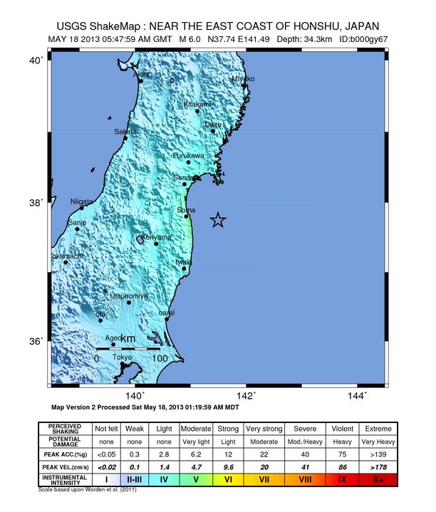
    The Earthquake/Seismic Activity Log - Page 40 Japan-may-18
    6.0 magnitude earthquake strikes off the coast of northeast Japan
    May 18, 2013 – JAPAN - An earthquake with a preliminary magnitude of 5.9 jolted northeastern Japan on Saturday, but no tsunami warning was issued, the Japan Meteorological Agency said. The earthquake was later upgraded by the USGS to a 6.0 magnitude. Tokyo Electric Power Co’s (9501.T) two nuclear plants in Fukushima reported no new irregularities after the quake, Kyodo news agency said. Onagawa nuclear plant in Miyagi prefecture further north also detected no irregularities, operator Tohoku Electric Power Co (9506.T) said. In Miyagi prefecture, where the shaking was the strongest, there were no information on injuries, Kyodo added. The United States Geological Survey recorded the quake at 6.1, with a depth of 20.5 miles. The epicenter of the quake was off the coast of Fukushima prefecture, more than 200 km (125 miles) northeast of Tokyo, where buildings also shook. A magnitude 9 earthquake in March 2011 in the northeast triggered a tsunami which killed about 16,000 people, with a further 3,000 still missing. The disaster caused meltdowns and crippled the Fukushima Daiichi nuclear plant. –Reuters India


    _________________
    What is life?
    It is the flash of a firefly in the night, the breath of a buffalo in the wintertime. It is the little shadow which runs across the grass and loses itself in the sunset.

    With deepest respect ~ Aloha & Mahalo, Carol
    Carol
    Carol
    Admin
    Admin


    Posts : 31699
    Join date : 2010-04-07
    Location : Hawaii

    The Earthquake/Seismic Activity Log - Page 40 Empty Re: The Earthquake/Seismic Activity Log

    Post  Carol Mon May 20, 2013 9:48 am

    The Earthquake/Seismic Activity Log - Page 40 Terremoto_Chile
    Shalllow 6.5 magnitude earthquake strikes off the coast of Aisen, Chile
    May 20, 2013 – SANTIAGO, Chile — The U.S. Geological Survey says a magnitude-6.5 earthquake has struck off the coast of Chile. The quake was recorded at 5:49 a.m. local time (EDT; 0949 GMT) Monday, at a shallow depth of 10 kilometres, some 600 kilometres from the city of Puerto Quellon. No tsunami warning was issued. Chile’s naval seismology office says it was not felt on land. U.S. seismologists originally estimated the magnitude at 6.8. Chile is one of the world’s most earthquake-prone countries. A magnitude-8.8 quake and the tsunami it unleashed in 2010 killed 551 people and destroyed 220,000 homes. It was so strong it changed time, shortening the Earth’s day slightly by changing the planet’s rotation. The strongest earthquake ever recorded also happened in Chile, a magnitude-9.5 in 1960. –CTV News


    _________________
    What is life?
    It is the flash of a firefly in the night, the breath of a buffalo in the wintertime. It is the little shadow which runs across the grass and loses itself in the sunset.

    With deepest respect ~ Aloha & Mahalo, Carol
    Carol
    Carol
    Admin
    Admin


    Posts : 31699
    Join date : 2010-04-07
    Location : Hawaii

    The Earthquake/Seismic Activity Log - Page 40 Empty Re: The Earthquake/Seismic Activity Log

    Post  Carol Mon May 20, 2013 9:49 am

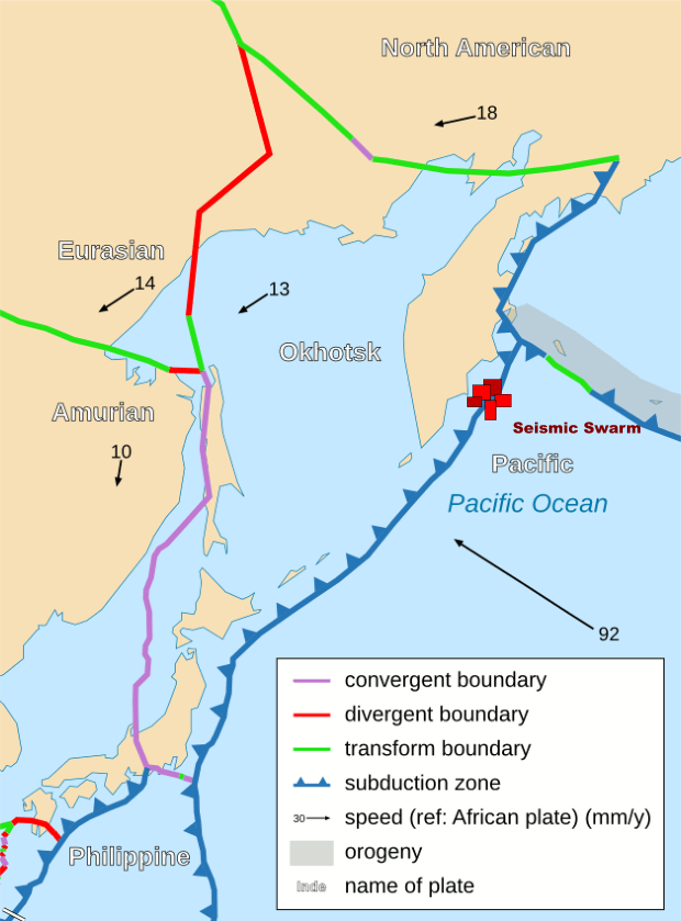
    The Earthquake/Seismic Activity Log - Page 40 Kamchatka-may-19
    Tension mounting on Pacific Plate: region of Kamchatka rocked by scores of earthquakes
    May 20, 2013 – KAMCHATKA – A massive earthquake swarm has occurred in the region of Petropavlovsk-Kamchatskiy, Russia. More than 20 earthquakes have struck the region in the last 22 hours- the strongest of which was a 5.9 magnitude earthquake, which rattled the seafloor at a depth of 16.5 km deep. The latest seismic flare-up along this region reflects growing agitation on one of the planet’s largest tectonic plates- the Pacific plate. Increasing seismic volatility along this region of Kamchatka could have serious ramifications for every tectonic plate that comes into contact with the Pacific plate- from the South Pacific to South America. A similar, more intense earthquake swarm occurred along the periphery of the Pacific Plate near the Santa Cruz Islands in February of this year. Is the Pacific plate on the verge of a large-scale change?

    The geology of the region: The Kuril-Kamchatka arc extends approximately 2,100 km from Hokkaido, Japan, along the Kuril Islands and the Pacific coast of the Kamchatka Peninsula to its intersection with the Aleutian arc near the Commander Islands, Russia. It marks the region where the Pacific plate subducts into the mantle beneath the Okhotsk micro-plate, part of the larger North American plate. This subduction is responsible for the generation of the Kuril Islands chain, active volcanoes located along the entire arc, and the deep offshore Kuril-Kamchatka trench. Relative to a fixed North America plate, the Pacific plate is moving towards the northwest at a rate that increases from 75 mm/year near the northern end of the arc to 83 mm/year in the south. Plate motion is predominantly convergent along the Kuril-Kamchatka arc with obliquity increasing towards the southern section of the arc. The subducting Pacific plate is relatively old, particularly adjacent to Kamchatka where its age is greater than 100 Ma. Consequently, the Wadati-Benioff zone is well defined to depths of approximately 650 km. The central section of the arc is comprised of an oceanic island arc system, which differs from the continental arc systems of the northern and southern sections. Oblique convergence in the southern Kuril arc results in the partitioning of stresses into both trench-normal thrust earthquakes and trench-parallel strike-slip earthquakes, and the westward translation of the Kuril forearc. This westward migration of the Kuril forearc currently results in collision between the Kuril arc in the north and the Japan arc in the south, resulting in the deformation and uplift of the Hidaka Mountains in central Hokkaido. The Kuril-Kamchatka arc is considered one of the most seismically active regions in the world. Deformation of the overriding North America plate generates shallow crustal earthquakes, whereas slip at the subduction zone interface between the Pacific and North America plates generates interplate earthquakes that extend from near the base of the trench to depths of 40 to 60 km. At greater depths, Kuril-Kamchatka arc earthquakes occur within the subducting Pacific plate and can reach depths of approximately 650 km. -USGS


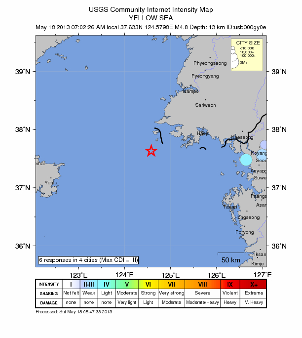
    The Earthquake/Seismic Activity Log - Page 40 Yellow-sea-quake
    Shallow 4.8 magnitude earthquake strikes in Yellow Sea off the coast of North Korea
    May 18, 2013 – NORTH KOREA – A 4.8 magnitude earthquake struck in the Yellow Sea, 76km WSW of Ongjin, North Korea. The earthquake struck under the sea at a depth of 13.50 km (8.39 mi). Many residents, living along coastal regions in South Korea, reported they felt the shaking inland. -TEP

    -------

    http://www.themistsofavalon.net/viewtopic.forum?t=7867


    _________________
    What is life?
    It is the flash of a firefly in the night, the breath of a buffalo in the wintertime. It is the little shadow which runs across the grass and loses itself in the sunset.

    With deepest respect ~ Aloha & Mahalo, Carol
    Carol
    Carol
    Admin
    Admin


    Posts : 31699
    Join date : 2010-04-07
    Location : Hawaii

    The Earthquake/Seismic Activity Log - Page 40 Empty Re: The Earthquake/Seismic Activity Log

    Post  Carol Thu Apr 30, 2015 1:27 pm

    Update 11:00 UTC : NO Tsunami (PWTC) - * AN EARTHQUAKE WITH A PRELIMINARY MAGNITUDE OF 6.8 OCCURRED IN THE NEW BRITAIN REGION, PAPUA NEW GUINEA AT 1045 UTC ON THURSDAY APRIL 30 2015.
    * BASED ON ALL AVAILABLE DATA… THERE IS NO TSUNAMI THREAT FROM THIS EARTHQUAKE

    Update 10:56 UTC : ER expects not to hear from any damage from this earthquake, mainly because it happened in a jungle area without roads and very few villages. Additionally M6.6 is not very spectacular for PNG who gets regularly M7+ earthquakes. Houses in the jungle have also a lot of resistance against earthquakes
    Screen Shot 2015-04-30 at 13.06.45


    _________________
    What is life?
    It is the flash of a firefly in the night, the breath of a buffalo in the wintertime. It is the little shadow which runs across the grass and loses itself in the sunset.

    With deepest respect ~ Aloha & Mahalo, Carol
    Carol
    Carol
    Admin
    Admin


    Posts : 31699
    Join date : 2010-04-07
    Location : Hawaii

    The Earthquake/Seismic Activity Log - Page 40 Empty Re: The Earthquake/Seismic Activity Log

    Post  Carol Tue May 12, 2015 9:50 am


    SRC Location UTC Date/time M D INFO
    ER I Felt A (not Listed) Earthquake May 12 23:59 4.6 0 MAP I Felt It
    Ankara - I felt weak shaking a couple of second.
    Tehran - Very weak shaking
    Thimphu - Felt the shaking and all of us came out of the office building.
    patna - we felt very clearly the buildings trees shaking for 3 times we all ran to ground from bal bhavan khilkari patana. no damages.. thank god.
    Thimphu - I was feeling dizziness. Suddenly everything around me starting shaking.
    kolkata - the office was vacated we are worried more about the people in NEPAL
    muzaffarpur,bihar - I was very afraid after this earthquake shocks but our teachers control us carefully.we earn a lesson that if earthquake comes do not panic
    dehli - none
    Jamalpur - The floor was shaking and felt as it was floating like a boat. The street lamp pole was moving to n fro just like a pendulum. It was very Scarry moment. Childrens and peoples were screaming.
    Thimphu - Most of us are mentally stressed and scared especially at night
    EMSC Iran-iraq Border Region May 12 13:24 3.6 10 MAP I Felt It INFO
    USGS Ramechhap, Nepal May 12 12:28 4.3 10 MAP I Felt It INFO
    EMSC Nepal May 12 12:28 4.3 10 MAP I Felt It INFO
    GEONET Rotorua May 12 12:26 3.1 212 MAP I Felt It INFO
    EMSC France May 12 12:13 3.3 0 MAP I Felt It INFO
    USGS Ramechhap, Nepal May 12 11:58 4.2 10 MAP I Felt It INFO
    EMSC Nepal May 12 11:58 4.2 10 MAP I Felt It INFO
    EMSC Antofagasta, Chile May 12 11:53 3.1 126 MAP I Felt It INFO
    USGS Kodari, Nepal May 12 11:21 4.2 10 MAP I Felt It INFO
    EMSC Nepal May 12 11:21 4.2 10 MAP I Felt It INFO
    GEONET Opunake May 12 11:09 3.1 215 MAP I Felt It INFO
    EMSC Azerbaijan May 12 10:52 3.4 8 MAP I Felt It INFO
    GEONET White Island May 12 10:44 3.3 270 MAP I Felt It INFO
    USGS Kodari, Nepal May 12 10:35 4.5 10 MAP I Felt It INFO
    EMSC Nepal May 12 10:35 4.5 10 MAP I Felt It INFO
    EMSC Crete, Greece May 12 10:17 3.9 2 MAP I Felt It INFO
    USGS Kodari, Nepal May 12 10:15 4.3 10 MAP I Felt It INFO
    EMSC Nepal May 12 10:15 4.3 2 MAP I Felt It INFO
    EMSC Crete, Greece May 12 10:06 2.9 12 MAP I Felt It
    USGS Hihifo, Tonga May 12 10:03 5.0 10 MAP I Felt It
    EMSC Tonga May 12 10:03 5.0 10 MAP I Felt It
    GEOFON Tonga Islands May 12 10:03 5.0 10 MAP I Felt It INFO
    EMSC Offshore Coquimbo, Chile May 12 09:21 3.5 37 MAP I Felt It INFO
    EMSC Hindu Kush Region, Afghanistan May 12 09:15 4.7 40 MAP I Felt It
    GEOFON Afghanistan-tajikistan Border Region May 12 09:15 4.8 61 MAP I Felt It INFO
    USGS Yangi Qal`ah, Afghanistan May 12 09:15 4.6 10 MAP I Felt It INFO
    EMSC Nepal May 12 09:02 4.5 10 MAP I Felt It INFO
    EMSC Nepal May 12 08:59 4.7 2 MAP I Felt It
    GEOFON Nepal May 12 08:59 4.7 10 MAP I Felt It INFO
    EMSC Strait Of Gibraltar May 12 08:54 2.9 41 MAP I Felt It
    GEONET Mokau May 12 08:54 3.2 253 MAP I Felt It INFO
    EMSC Nepal May 12 08:34 4.8 10 MAP I Felt It
    GEOFON Nepal May 12 08:34 4.8 10 MAP I Felt It
    EMSC Nepal May 12 08:21 5.3 10 MAP I Felt It
    USGS Kodari, Nepal May 12 08:21 5.2 15 MAP I Felt It
    GEOFON Nepal May 12 08:21 5.2 10 MAP I Felt It
    EMSC Nepal May 12 08:21 5.2 10 MAP I Felt It
    EMSC Nepal May 12 08:13 5.2 10 MAP I Felt It
    USGS Kodari, Nepal May 12 08:13 5.1 15 MAP I Felt It
    GEOFON Nepal May 12 08:13 5.2 10 MAP I Felt It
    EMSC Greece May 12 08:07 3.0 8 MAP I Felt It INFO
    USGS Kodari, Nepal May 12 08:06 5.0 15 MAP I Felt It
    EMSC Nepal May 12 08:06 5.1 10 MAP I Felt It
    GEOFON Nepal May 12 08:06 5.3 10 MAP I Felt It INFO
    USGS Sterling, Alaska May 12 07:54 2.9 51 MAP I Felt It
    EMSC Nepal May 12 07:48 5.0 10 MAP I Felt It
    GEOFON Nepal May 12 07:48 5.0 10 MAP I Felt It
    EMSC Salta, Argentina May 12 07:37 4.5 167 MAP I Felt It INFO
    USGS Ramechhap, Nepal May 12 07:36 6.3 15 MAP I Felt It


    _________________
    What is life?
    It is the flash of a firefly in the night, the breath of a buffalo in the wintertime. It is the little shadow which runs across the grass and loses itself in the sunset.

    With deepest respect ~ Aloha & Mahalo, Carol

      Current date/time is Fri Apr 26, 2024 3:51 am