


+21
Aquaries1111
giovonni
arvan33
Floyd
lawlessline
JesterTerrestrial
THEeXchanger
newel
Brook
greybeard
Mercuriel
Sanicle
devakas
hobbit
mudra
burgundia
lindabaker
LeeEllisMusic
MargueriteBee
Carol
HigherLove
25 posters
The Earthquake/Seismic Activity Log

Carol- Admin

- Posts : 32911
Join date : 2010-04-07
Location : Hawaii
_________________
What is life?
It is the flash of a firefly in the night, the breath of a buffalo in the wintertime. It is the little shadow which runs across the grass and loses itself in the sunset.
With deepest respect ~ Aloha & Mahalo, Carol


HigherLove- Posts : 2357
Join date : 2011-01-27
Age : 59
Magnitude 6.5
Date-Time
Sunday, December 11, 2011 at 01:47:26 UTC
Saturday, December 10, 2011 at 07:47:26 PM at epicenter
Time of Earthquake in other Time Zones
Location 18.038°N, 99.796°W
Depth 64.9 km (40.3 miles)
Region GUERRERO, MEXICO
Distances 42 km (26 miles) SW of Iguala, Guerrero, Mexico
56 km (34 miles) ESE of Arcelia, Guerrero, Mexico
62 km (38 miles) NNW of Chilpancingo, Guerrero, Mexico
166 km (103 miles) SSW of MEXICO CITY, D.F., Mexico
Location Uncertainty horizontal +/- 14.5 km (9.0 miles); depth +/- 9.8 km (6.1 miles)
Parameters NST=488, Nph=488, Dmin=140.3 km, Rmss=0.78 sec, Gp= 43°,
M-type=regional moment magnitude (Mw), Version=8
Source
Magnitude: USGS NEIC (WDCS-D)
Location: USGS NEIC (WDCS-D)
Event ID usc000753u
Very strong earthquake near Iguala, Mexico – 2 people killed + damaged buildings in Mexico City
http://earthquake-report.com/2011/12/11/very-strong-earthquake-at-intermediate-depth-near-iguala-mexico/
Strong earthquake rattles Mexico, two dead
MEXICO CITY - A powerful 6.7 magnitude earthquake shook Mexico Saturday, killing at least two people, knocking out lights in parts of the capital and sending people rushing into the streets.
There were no immediate reports of severe damage or injuries in Mexico City but emergency services said one person was killed when a house collapsed in Iguala, a small city between the capital and the tourist resort of Acapulco.
Another person was killed when a rock fell on a small van on the Mexico City-Acapulco highway.
“I was dreadfully afraid, I thought it was never going to end,” said Laura Gonzalez, who was drinking in a bar in the capital at the time of the quake, which lasted 40 seconds.
A severe earthquake in 1985 killed thousands of people and wrecked parts of Mexico City, and many residents live with the fear of a repeat.
“I was on the fifth floor when I felt it. It was a very strong shake,” said Amor Lajud. “My dogs started barking. I just rushed out for the exit and got out.
Lajud lives in an apartment building in the fashionable Condesa neighborhood of Mexico City, which suffered serious damage in the 1985 quake.
http://www.lfpress.com/news/world/2011/12/10/19107346.html
Carol- Admin
- Posts : 32911
Join date : 2010-04-07
Location : Hawaii

Strong 6.7 magnitude earthquake strikes Guerrero Mexico- 3 dead
Something shook New Jersey on Saturday, but it wasn't an earthquake -
Mystery tremor leaves New Jersey residents puzzled
December 11, 2011 – NEW JERSEY – Local residents felt a slight tremor at about 10 a.m. Saturday. Residents in Newark, Bergen County and Sussex County felt it, too — something that made houses shake and water ripple. It wasn’t an earthquake. But what was it? U.S. Geological Survey geophysicist Paul Caruso isn’t sure. “We received a number of reports that people felt something,” Caruso said from the National Earthquake Information Center in Colorado. “We don’t know what it was.” Local residents took to Facebook and Twitter to describe what they thought was an earthquake. “I felt it in Margate, thought I was having a stroke!” wrote Patti Fiore. Caruso has some theories as to what caused the shaking sensation, but at this point it’s merely speculation. “It could have possibly been a thunderstorm off the coast,” Caruso said. “A sonic boom, that’s another possibility.” Caruso said this sort of thing happens several times a year, usually off the coast of Florida. New Jersey has become more earthquake-conscious since August, when a 5.8-magnitude earthquake shook the East Coast. –Press of Atlantic CityMystery tremor leaves New Jersey residents puzzled
http://www.pressofatlanticcity.com/news/breaking/something-shook-new-jersey-on-saturday-but-it-wasn-t/article_7e9db9ea-2343-11e1-ab94-0019bb2963f4.html
Floors shook, bottles rattled, bells jingled, and scores of New Jersey residents up and down the state cried “earthquake!” yesterday morning. Was this the state’s second rattler in four months? Despite more than 60 residents who claimed to have felt shaking yesterday morning, a spokesman for the U.S. Geological Survey said none of the seismometers stationed around the state picked up even a hint of trembling. “It’s not an earthquake,” said geophysicist John Bellini, speaking from the U.S. Geological Survey’s Colorado office. “My guess would be it’s more likely thunder or a sonic boom.” -NJ http://www.nj.com/news/index.ssf/2011/12/dozens_in_nj_report_feeling_ea.html

6.2 magnitude earthquake strikes Sandwich Islands but it has even broader implications
Idukki region of India shaken once again by rumbling tremors
http://www.thehindu.com/news/states/kerala/article2704216.ece
December 10, 2011 – INDIA – For the third time within a month, high ranges of the district, bordering neighboring Idukki, experienced tremors when mild earthquake shook Erattupetta and adjoining areas on Saturday afternoon. According to reports, Poonjar, Poonjar Thekkekkara, Teekoy, Wagamon and Adukkom Erattupetta areas experienced mild tremors accompanied by deep rumbling sounds. The tremors hit by 3:30 p.m., almost the same time when parts of the Idukki district experienced tremors. There are no reports of loss to life and property. The same areas experienced tremors on November 18 and November 26. The one on November 26 had recorded a magnitude of 3.2 on the Richter scale. –The Hinduhttp://www.thehindu.com/news/states/kerala/article2704216.ece
Update time = Sun Dec 11 16:00:01 UTC 2011
MAG UTC DATE-TIME y/m/d h:m:s LAT deg LON deg DEPTH km Region
MAP 2.8 2011/12/11 13:34:16 37.657 -115.295 4.9 NEVADA
MAP 4.6 2011/12/11 12:38:58 39.373 94.126 20.9 GANSU-QINGHAI BORDER REGION, CHINA
MAP 6.2 2011/12/11 09:54:55 -55.980 -28.238 115.5 SOUTH SANDWICH ISLANDS REGION
MAP 4.6 2011/12/11 09:40:10 -0.051 125.894 62.7 MOLUCCA SEA
MAP 4.9 2011/12/11 08:31:03 -36.162 -71.523 81.5 MAULE, CHILE
MAP 2.6 2011/12/11 07:40:19 63.361 -151.891 4.6 CENTRAL ALASKA
MAP 4.3 2011/12/11 06:34:19 -8.157 107.268 35.0 JAVA, INDONESIA
MAP 2.8 2011/12/11 05:36:00 36.938 -104.849 4.9 NEW MEXICO
MAP 5.4 2011/12/11 05:30:58 -24.085 178.544 560.3 SOUTH OF THE FIJI ISLANDS
MAP 4.9 2011/12/11 05:04:31 34.470 142.403 24.4 OFF THE EAST COAST OF HONSHU, JAPAN
MAP 2.7 2011/12/11 04:09:01 18.685 -66.775 66.3 PUERTO RICO REGION
MAP 4.4 2011/12/11 03:34:36 13.102 -88.486 65.7 OFFSHORE EL SALVADOR
MAP 6.5 2011/12/11 01:47:26 18.038 -99.796 64.9 GUERRERO, MEXICO
MAP 5.8 2011/12/11 01:22:45 28.074 129.433 27.9 RYUKYU ISLANDS, JAPAN
MAP 4.5 2011/12/11 01:10:26 -7.607 127.523 172.3 KEPULAUAN BARAT DAYA, INDONESIA
http://earthquake.usgs.gov/earthquakes/recenteqsww/Quakes/quakes_all.php
_________________
What is life?
It is the flash of a firefly in the night, the breath of a buffalo in the wintertime. It is the little shadow which runs across the grass and loses itself in the sunset.
With deepest respect ~ Aloha & Mahalo, Carol
Carol- Admin
- Posts : 32911
Join date : 2010-04-07
Location : Hawaii
Residents puzzled by recent flurry of earthquakes in Maine
http://www.boston.com/Boston/metrodesk/2011/12/two-more-earthquakes-reported-maine/yPGvxEV2deWNcRxviIn3ZL/index.html
December 14, 2011 – MAINE – The central coast of Maine was hit by two small earthquakes at nearly the same moment Monday night. The earthquakes, which measured 2.3 and 1.9 on the Richter scale, occurred about a second apart, at 11:41 p.m. The epicenters were about 4 miles apart in an area of Hancock County near Ellsworth and Searsport, according to a preliminary earthquake report released by the United States Geological Survey. More than 25 people have logged on to the USGS website so far to say they felt the quakes. Four reports came from the town of Blue Hill, where one epicenter was located. Ten reports came from the town of Sedgewick, the second epicenter. “I thought a big giant tree had crashed into my house,” said Shari Whelan, a resident of Sedgewick who works as a general manager at the Barncastle Hotel and Restaurant in Blue Hill. Whelan said she was watching television when the house began to shake and she heard a “boom,” that sounded like thunder. The two quakes were the third and fourth recorded in the state in two days. On Sunday afternoon and night, quakes measuring 1.0 and 1.4 on the Richter scale, respectively, were recorded in central Maine about 80 miles away. “This area of Maine does get a lot of earthquakes,” said Justin Starr, a research assistant at the Weston Observatory, the Boston College geophysical observatory. He said he didn’t know why there has been a flurry of activity in the area. -Bostonhttp://www.boston.com/Boston/metrodesk/2011/12/two-more-earthquakes-reported-maine/yPGvxEV2deWNcRxviIn3ZL/index.html
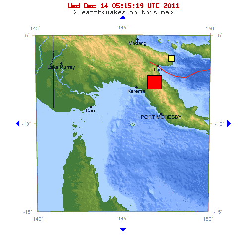
7.1 magnitude earthquake strikes Bismarck Island arc of Papua New Guinea

http://www.volcanodiscovery.com/view_news/4206/Kolumbus-submarine-volcano-Santorini-Greece-32-magnitude-earthquake.html
Greek submarine volcano near Santorini Island rattled by 3.2 magnitude earthquake
_________________
What is life?
It is the flash of a firefly in the night, the breath of a buffalo in the wintertime. It is the little shadow which runs across the grass and loses itself in the sunset.
With deepest respect ~ Aloha & Mahalo, Carol
HigherLove- Posts : 2357
Join date : 2011-01-27
Age : 59
Thanks Carol.
i have had so much time off that i aggravated an ergonomic situation with my dominant arm.
i was up when this came in on the earthquake meter...i could not raise my arm.
has happened before...
...do not sit sideways at your desk!!!
Carol- Admin
- Posts : 32911
Join date : 2010-04-07
Location : Hawaii

http://www.croatiantimes.com/news/General_News/2011-12-14/23881/Montenegro_earthquake_shakes_up_Dubrovnik
Montenegro earthquake shakes up Dubrovnik

6.3 magnitude earthquake strikes seafloor south of Kermadec Islands
You're welcome Troy. All too happy to lend a helping hand. Just hope your shoulder heals quickly. Been there, done that, wasn't f
un._________________
What is life?
It is the flash of a firefly in the night, the breath of a buffalo in the wintertime. It is the little shadow which runs across the grass and loses itself in the sunset.
With deepest respect ~ Aloha & Mahalo, Carol
Carol- Admin
- Posts : 32911
Join date : 2010-04-07
Location : Hawaii
You're welcome Troy. I hope your arm is healing and well on the mend.
Region hit by earthquake: The same ocean off the Coast of Mindanao Island that spawned Tropical Storm Washi was hit today by a 4.8 magnitude earthquake- an indication that disasters can and will soon strike in cascading clusters. The deep 4.8 magnitude earthquake struck along the seafloor of the Philippine Islands Arc which straddles the Philippine Trench. The Philippine archipelago lies in the deadly crosshairs of a web of subducting tectonic plates and sub-plates- most notably the Pacific and the Eurasian plates. A 4.6 magnitude earthquake also struck the Mediterranean region just south of Sicily. Earthquakes also struck Mexico, Panama, Pakistan, and Japan.
DATE LAT LON MAG DEPTH km REGION
19-DEC-2011 08:12:48 51.15 -130.01 4.0 10.0 QUEEN CHARLOTTE ISLANDS REGION
19-DEC-2011 07:46:22 57.23 -150.61 4.0 12.5 GULF OF ALASKA
19-DEC-2011 07:01:48 35.42 140.96 4.6 45.1 NEAR EAST COAST OF HONSHU, JAPAN
19-DEC-2011 05:38:00 -12.07 -76.92 4.8 66.9 NEAR COAST OF PERU
19-DEC-2011 05:32:15 -29.24 -176.21 5.3 29.4 KERMADEC ISLANDS REGION
19-DEC-2011 05:24:48 -23.74 -66.80 4.7 184.7 JUJUY PROVINCE, ARGENTINA
19-DEC-2011 04:13:48 43.86 147.84 4.8 81.3 KURIL ISLANDS
19-DEC-2011 03:55:11 38.27 142.48 4.6 49.2 NEAR EAST COAST OF HONSHU, JAPAN
19-DEC-2011 02:00:32 -7.41 128.17 4.7 171.2 BANDA SEA
19-DEC-2011 01:23:27 -1.31 119.55 5.7 33.0 SULAWESI, INDONESIA
18-DEC-2011 20:08:32 -5.56 148.52 4.8 180.2 NEW BRITAIN REGION, P.N.G.
18-DEC-2011 16:24:01 6.73 123.80 4.8 603.3 MINDANAO, PHILIPPINE ISLANDS
18-DEC-2011 15:01:05 36.04 13.04 4.6 19.2 CENTRAL MEDITERRANEAN SEA
18-DEC-2011 13:47:07 7.42 -82.14 4.6 10.0 SOUTH OF PANAMA
18-DEC-2011 12:28:10 36.37 71.57 4.6 121.4 AFGHANISTAN-TAJIKISTAN BORD REG.
18-DEC-2011 09:02:02 35.52 140.91 4.9 24.2 NEAR EAST COAST OF HONSHU, JAPAN
18-DEC-2011 06:08:57 38.65 142.35 4.8 43.4 NEAR EAST COAST OF HONSHU, JAPAN
18-DEC-2011 05:03:19 15.80 -92.01 4.5 221.0 MEXICO-GUATEMALA BORDER REGION
17-DEC-2011 22:42:24 -22.47 179.27 5.0 615.0 SOUTH OF FIJI ISLANDS
17-DEC-2011 20:54:20 -59.76 -26.44 5.3 68.7 SOUTH SANDWICH ISLANDS REGION
17-DEC-2011 12:53:22 37.69 134.06 4.0 434.2 SEA OF JAPAN
17-DEC-2011 10:18:18 -32.82 -178.61 5.0 11.0 SOUTH OF KERMADEC ISLANDS
17-DEC-2011 08:48:19 45.33 147.58 4.7 169.2 KURIL ISLANDS
17-DEC-2011 06:14:19 18.16 -67.34 4.0 20.1 MONA PASSAGE
17-DEC-2011 06:09:09 18.17 -67.37 5.3 17.0 MONA PASSAGE
17-DEC-2011 06:06:12 18.19 -67.37 5.1 14.0 MONA PASSAGE
17-DEC-2011 06:04:55 4.23 122.88 4.8 580.5 CELEBES SEA
17-DEC-2011 00:12:18 -52.49 26.54 4.9 10.0 SOUTH OF AFRICA
16-DEC-2011 23:18:03 -10.74 102.14 5.2 10.0 SOUTHWEST OF SUMATERA, INDONESIA
16-DEC-2011 23:16:45 7.26 -77.92 4.6 35.0 PANAMA-COLOMBIA BORDER REGION
16-DEC-2011 21:49:37 -55.99 -143.62 5.3 10.0 PACIFIC-ANTARCTIC RIDGE
16-DEC-2011 20:42:24 -6.89 129.41 4.7 176.5 BANDA SEA
16-DEC-2011 19:30:17 4.23 93.31 5.2 26.2 OFF W COAST OF NORTHERN SUMATERA
16-DEC-2011 15:47:26 7.66 93.98 4.9 46.0 NICOBAR ISLANDS, INDIA
16-DEC-2011 15:12:47 7.78 94.16 4.9 68.1 NICOBAR ISLANDS, INDIA
16-DEC-2011 13:02:26 16.45 -98.03 4.8 25.9 NEAR COAST OF GUERRERO, MEXICO
16-DEC-2011 12:54:25 -45.85 -76.26 5.8 10.0 OFF COAST OF SOUTHERN CHILE
16-DEC-2011 12:02:57 -45.85 -76.08 5.2 9.9 OFF COAST OF SOUTHERN CHILE
16-DEC-2011 12:02:57 -45.85 -76.08 4.2 9.9 OFF COAST OF SOUTHERN CHILE
16-DEC-2011 12:02:57 -45.85 -76.08 5.2 9.9 OFF COAST OF SOUTHERN CHILE
16-DEC-2011 06:12:03 36.35 139.93 4.8 83.0 EASTERN HONSHU, JAPAN
16-DEC-2011 05:27:27 38.43 142.18 4.9 9.9 NEAR EAST COAST OF HONSHU, JAPAN
16-DEC-2011 04:06:17 6.95 -73.19 4.1 171.9 NORTHERN COLOMBIA
16-DEC-2011 00:58:47 -37.20 -73.91 4.4 31.8 NEAR COAST OF CENTRAL CHILE
_________________
What is life?
It is the flash of a firefly in the night, the breath of a buffalo in the wintertime. It is the little shadow which runs across the grass and loses itself in the sunset.
With deepest respect ~ Aloha & Mahalo, Carol
HigherLove- Posts : 2357
Join date : 2011-01-27
Age : 59
MAP 4.1 2011/12/20 16:06:46 44.151 -128.705 10.2 364 km (226 mi) WNW of Bandon, OR
MAP 3.2 2011/12/20 11:45:24 19.187 -66.640 49.4 80 km ( 50 mi) N of Carrizales, PR
MAP 3.6 2011/12/20 08:32:23 34.023 -117.577 1.6 6 km ( 4 mi) SE of Ontario, CA
MAP 3.2 2011/12/20 05:06:36 36.560 -121.126 2.9 4 km ( 2 mi) NNE of Pinnacles, CA
Magnitude 4.1
Date-Time
Tuesday, December 20, 2011 at 16:06:46 UTC
Tuesday, December 20, 2011 at 07:06:46 AM at epicenter
Time of Earthquake in other Time Zones
Location 44.151°N, 128.705°W
Depth 10.2 km (6.3 miles)
Region OFF THE COAST OF OREGON
Distances 372 km (231 miles) WNW of Coos Bay, Oregon
374 km (232 miles) W of Newport, Oregon
429 km (266 miles) NW of Brookings, Oregon
459 km (285 miles) W of SALEM, Oregon
Location Uncertainty horizontal +/- 17.1 km (10.6 miles); depth +/- 2.6 km (1.6 miles)
Parameters NST= 95, Nph= 97, Dmin=430.8 km, Rmss=1.28 sec, Gp=169°,
M-type=body wave magnitude (Mb), Version=6
Source
Magnitude: USGS NEIC (WDCS-D)
Location: USGS NEIC (WDCS-D)
Event ID usc000795f
HigherLove- Posts : 2357
Join date : 2011-01-27
Age : 59
Kermadec Islands continue to be very active, as is Hindu Kush region of Afghanistan --
MAP 4.6 2011/12/21 13:59:44 36.514 70.809 201.6 HINDU KUSH REGION, AFGHANISTAN
MAP 5.5 2011/12/21 13:37:15 -33.172 -179.021 10.0 SOUTH OF THE KERMADEC ISLANDS
MAP 4.4 2011/12/21 13:36:09 38.498 133.750 450.8 SEA OF JAPAN
MAP 4.2 2011/12/21 09:43:46 35.829 25.898 125.8 CRETE, GREECE
MAP 4.2 2011/12/21 09:21:13 -19.433 -177.710 583.9 FIJI REGION
MAP 5.1 2011/12/21 08:20:30 22.301 142.227 5.9 VOLCANO ISLANDS, JAPAN REGION
MAP 4.8 2011/12/21 05:33:19 1.738 -102.172 10.0 GALAPAGOS TRIPLE JUNCTION REGION
MAP 4.7 2011/12/21 03:04:07 31.996 141.659 33.3 IZU ISLANDS, JAPAN REGION
MAP 3.0 2011/12/21 02:17:25 63.626 -150.590 6.6 CENTRAL ALASKA
MAP 4.7 2011/12/21 02:06:54 39.594 141.999 62.5 EASTERN HONSHU, JAPAN
MAP 2.7 2011/12/21 02:05:58 35.365 -92.255 4.6 ARKANSAS
_______
MAP 4.9 2011/12/20 23:37:56 -29.070 -176.817 1.0 KERMADEC ISLANDS REGION
MAP 4.5 2011/12/20 22:53:02 12.980 -89.572 63.1 OFFSHORE EL SALVADOR
MAP 2.7 2011/12/20 20:42:35 32.472 -115.648 6.4 BAJA CALIFORNIA, MEXICO
MAP 2.5 2011/12/20 19:46:55 59.020 -153.443 9.9 SOUTHERN ALASKA
MAP 2.5 2011/12/20 19:40:47 36.560 -121.127 4.2 CENTRAL CALIFORNIA
MAP 2.6 2011/12/20 19:02:15 38.057 -118.871 6.0 CENTRAL CALIFORNIA
MAP 5.0 2011/12/20 18:45:35 -7.221 127.556 266.6 KEPULAUAN BARAT DAYA, INDONESIA
MAP 2.7 2011/12/20 17:44:40 36.562 -121.126 4.8 CENTRAL CALIFORNIA
MAP 2.5 2011/12/20 16:55:31 35.367 -92.285 5.6 ARKANSAS
MAP 2.7 2011/12/20 16:28:34 18.005 -67.163 14.0 PUERTO RICO
MAP 4.1 2011/12/20 16:06:46 44.150 -128.720 10.0 OFF THE COAST OF OREGON
MAP 4.8 2011/12/20 12:26:37 28.730 128.689 157.6 RYUKYU ISLANDS, JAPAN
MAP 3.2 2011/12/20 11:45:24 19.187 -66.640 49.4 PUERTO RICO REGION
MAP 3.8 2011/12/20 09:15:53 52.066 -171.495 46.3 FOX ISLANDS, ALEUTIAN ISLANDS, ALASKA
MAP 3.5 2011/12/20 08:32:24 34.010 -117.588 4.4 GREATER LOS ANGELES AREA, CALIFORNIA
MAP 4.6 2011/12/20 07:33:55 7.337 -78.605 36.2 PANAMA
MAP 4.8 2011/12/20 06:26:23 40.114 142.576 46.9 NEAR THE EAST COAST OF HONSHU, JAPAN
MAP 2.5 2011/12/20 05:07:26 36.560 -121.125 4.8 CENTRAL CALIFORNIA
MAP 3.0 2011/12/20 05:06:37 36.561 -121.128 4.6 CENTRAL CALIFORNIA
MAP 2.5 2011/12/20 03:35:09 61.405 -140.119 0.0 SOUTHERN YUKON TERRITORY, CANADA
MAP 4.9 2011/12/20 03:34:49 13.343 122.443 36.8 LUZON, PHILIPPINES
MAP 4.7 2011/12/20 03:03:16 -3.058 142.079 55.4 NEAR NORTH COAST OF NEW GUINEA, P.N.G.
MAP 5.0 2011/12/20 01:54:20 14.213 -93.177 45.7 OFF THE COAST OF CHIAPAS, MEXICO
MAP 4.9 2011/12/20 01:26:54 -47.443 100.039 9.9 SOUTHEAST INDIAN RIDGE
MAP 4.5 2011/12/20 01:22:24 27.221 140.151 362.5 BONIN ISLANDS, JAPAN REGION
MAP 4.5 2011/12/20 00:35:17 -30.121 -176.969 10.0 KERMADEC ISLANDS REGION
Magnitude 3.5
Date-Time
Tuesday, December 20, 2011 at 08:32:23 UTC
Tuesday, December 20, 2011 at 12:32:23 AM at epicenter
Time of Earthquake in other Time Zones
Location 34.010°N, 117.588°W
Depth 4.4 km (2.7 miles)
Region GREATER LOS ANGELES AREA, CALIFORNIA
Distances
6 km (4 miles) SE (142°) from Ontario, CA
7 km (4 miles) WNW (293°) from Mira Loma, CA
9 km (6 miles) E (95°) from Chino, CA
61 km (38 miles) E (95°) from Los Angeles Civic Center, CA
Location Uncertainty horizontal +/- 0.2 km (0.1 miles); depth +/- 0.2 km (0.1 miles)
Parameters Nph=178, Dmin=3 km, Rmss=0.24 sec, Gp= 14°,
M-type=local magnitude (ML), Version=5
Source
California Integrated Seismic Net:
USGS Caltech CGS UCB UCSD UNR
Event ID ci15088052
______________
The Hindu Kush Seismic Zone as a Paradigm for the Creation of Ultrahigh-Pressure Diamond- and Coesite-Bearing Continental Rocks:
http://www.geol.ucsb.edu/faculty/hacker/viz/Searle01_Hindu_Kush_UHP_paradigm.pdf
http://www.google.com/search?q=hindu+kush+fault+lines&ie=utf-8&oe=utf-8&aq=t&rls=org.mozilla:en-US:official&client=firefox-a
MAP 4.6 2011/12/21 13:59:44 36.514 70.809 201.6 HINDU KUSH REGION, AFGHANISTAN
MAP 5.5 2011/12/21 13:37:15 -33.172 -179.021 10.0 SOUTH OF THE KERMADEC ISLANDS
MAP 4.4 2011/12/21 13:36:09 38.498 133.750 450.8 SEA OF JAPAN
MAP 4.2 2011/12/21 09:43:46 35.829 25.898 125.8 CRETE, GREECE
MAP 4.2 2011/12/21 09:21:13 -19.433 -177.710 583.9 FIJI REGION
MAP 5.1 2011/12/21 08:20:30 22.301 142.227 5.9 VOLCANO ISLANDS, JAPAN REGION
MAP 4.8 2011/12/21 05:33:19 1.738 -102.172 10.0 GALAPAGOS TRIPLE JUNCTION REGION
MAP 4.7 2011/12/21 03:04:07 31.996 141.659 33.3 IZU ISLANDS, JAPAN REGION
MAP 3.0 2011/12/21 02:17:25 63.626 -150.590 6.6 CENTRAL ALASKA
MAP 4.7 2011/12/21 02:06:54 39.594 141.999 62.5 EASTERN HONSHU, JAPAN
MAP 2.7 2011/12/21 02:05:58 35.365 -92.255 4.6 ARKANSAS
_______
MAP 4.9 2011/12/20 23:37:56 -29.070 -176.817 1.0 KERMADEC ISLANDS REGION
MAP 4.5 2011/12/20 22:53:02 12.980 -89.572 63.1 OFFSHORE EL SALVADOR
MAP 2.7 2011/12/20 20:42:35 32.472 -115.648 6.4 BAJA CALIFORNIA, MEXICO
MAP 2.5 2011/12/20 19:46:55 59.020 -153.443 9.9 SOUTHERN ALASKA
MAP 2.5 2011/12/20 19:40:47 36.560 -121.127 4.2 CENTRAL CALIFORNIA
MAP 2.6 2011/12/20 19:02:15 38.057 -118.871 6.0 CENTRAL CALIFORNIA
MAP 5.0 2011/12/20 18:45:35 -7.221 127.556 266.6 KEPULAUAN BARAT DAYA, INDONESIA
MAP 2.7 2011/12/20 17:44:40 36.562 -121.126 4.8 CENTRAL CALIFORNIA
MAP 2.5 2011/12/20 16:55:31 35.367 -92.285 5.6 ARKANSAS
MAP 2.7 2011/12/20 16:28:34 18.005 -67.163 14.0 PUERTO RICO
MAP 4.1 2011/12/20 16:06:46 44.150 -128.720 10.0 OFF THE COAST OF OREGON
MAP 4.8 2011/12/20 12:26:37 28.730 128.689 157.6 RYUKYU ISLANDS, JAPAN
MAP 3.2 2011/12/20 11:45:24 19.187 -66.640 49.4 PUERTO RICO REGION
MAP 3.8 2011/12/20 09:15:53 52.066 -171.495 46.3 FOX ISLANDS, ALEUTIAN ISLANDS, ALASKA
MAP 3.5 2011/12/20 08:32:24 34.010 -117.588 4.4 GREATER LOS ANGELES AREA, CALIFORNIA
MAP 4.6 2011/12/20 07:33:55 7.337 -78.605 36.2 PANAMA
MAP 4.8 2011/12/20 06:26:23 40.114 142.576 46.9 NEAR THE EAST COAST OF HONSHU, JAPAN
MAP 2.5 2011/12/20 05:07:26 36.560 -121.125 4.8 CENTRAL CALIFORNIA
MAP 3.0 2011/12/20 05:06:37 36.561 -121.128 4.6 CENTRAL CALIFORNIA
MAP 2.5 2011/12/20 03:35:09 61.405 -140.119 0.0 SOUTHERN YUKON TERRITORY, CANADA
MAP 4.9 2011/12/20 03:34:49 13.343 122.443 36.8 LUZON, PHILIPPINES
MAP 4.7 2011/12/20 03:03:16 -3.058 142.079 55.4 NEAR NORTH COAST OF NEW GUINEA, P.N.G.
MAP 5.0 2011/12/20 01:54:20 14.213 -93.177 45.7 OFF THE COAST OF CHIAPAS, MEXICO
MAP 4.9 2011/12/20 01:26:54 -47.443 100.039 9.9 SOUTHEAST INDIAN RIDGE
MAP 4.5 2011/12/20 01:22:24 27.221 140.151 362.5 BONIN ISLANDS, JAPAN REGION
MAP 4.5 2011/12/20 00:35:17 -30.121 -176.969 10.0 KERMADEC ISLANDS REGION
Magnitude 3.5
Date-Time
Tuesday, December 20, 2011 at 08:32:23 UTC
Tuesday, December 20, 2011 at 12:32:23 AM at epicenter
Time of Earthquake in other Time Zones
Location 34.010°N, 117.588°W
Depth 4.4 km (2.7 miles)
Region GREATER LOS ANGELES AREA, CALIFORNIA
Distances
6 km (4 miles) SE (142°) from Ontario, CA
7 km (4 miles) WNW (293°) from Mira Loma, CA
9 km (6 miles) E (95°) from Chino, CA
61 km (38 miles) E (95°) from Los Angeles Civic Center, CA
Location Uncertainty horizontal +/- 0.2 km (0.1 miles); depth +/- 0.2 km (0.1 miles)
Parameters Nph=178, Dmin=3 km, Rmss=0.24 sec, Gp= 14°,
M-type=local magnitude (ML), Version=5
Source
California Integrated Seismic Net:
USGS Caltech CGS UCB UCSD UNR
Event ID ci15088052
______________
The Hindu Kush Seismic Zone as a Paradigm for the Creation of Ultrahigh-Pressure Diamond- and Coesite-Bearing Continental Rocks:
http://www.geol.ucsb.edu/faculty/hacker/viz/Searle01_Hindu_Kush_UHP_paradigm.pdf
The Hindu Kush, which marks the fault line of the Iranian and Eurasian tectonic plates, runs more or less from the east to the west, and many small rivers run down from its slopes to the north, deposeting sediments on the foothills and the plain that runs parallel to the mountain range. Consequently, this is a very fertile area, where farmers produced wheat and barley in very ancient times. Their culture, known as the Bactria-Margiana Archaeological Complex (BMAC), can be dated to c.2200-1700 and is sometimes associated with the arrival of the Indo-Iranians.
http://www.livius.org/ba-bd/bactria/bactria.html
http://www.google.com/search?q=hindu+kush+fault+lines&ie=utf-8&oe=utf-8&aq=t&rls=org.mozilla:en-US:official&client=firefox-a
Carol- Admin
- Posts : 32911
Join date : 2010-04-07
Location : Hawaii

http://www.oregonlive.com/environment/index.ssf/2011/12/geologists_wonder_if_the_north.html
Geologists wonder if the Northwest is up next for a giant earthquake
_________________
What is life?
It is the flash of a firefly in the night, the breath of a buffalo in the wintertime. It is the little shadow which runs across the grass and loses itself in the sunset.
With deepest respect ~ Aloha & Mahalo, Carol
Carol- Admin
- Posts : 32911
Join date : 2010-04-07
Location : Hawaii
http://www.groundreport.com/Business/No-need-to-get-panicky-of-Earth-quake-warning-Renz/2943236
Seismologist says 9.0 magnitude earthquake could destroy much of Kashmir Valley
_________________
What is life?
It is the flash of a firefly in the night, the breath of a buffalo in the wintertime. It is the little shadow which runs across the grass and loses itself in the sunset.
With deepest respect ~ Aloha & Mahalo, Carol
HigherLove- Posts : 2357
Join date : 2011-01-27
Age : 59
Indonesia

Seismotectonics of the Indonesian Region
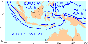
Tectonics Plates
The Indonesian region is one of the most seismically active zones of the earth; at the same time it has a leading position from the point of view of active and potentially active volcanoes. It is a typical island-arc structure with its characteristic physiographic features, such as a deep oceanic trench, a geanticline belt, a volcanic inner arc and a marginal basin.
In most subduction zones, motion of the subducted plate is nearly perpendicular to the trench axis. In some cases, for example Sumatra, where the motion is oblique to the axis, a strike-slip fault zone is seen, and is lying parallel to the volcanic chain.
In the subduction zone southwest of Sumatra, the Sunda trench axis strikes approximately N 37°W. The Indian Ocean crust is moving in an azimuth of approximately N 23°E relative to Southeast Asia, giving an angle of obliquity of 60°. Eastern Indonesia, forming the southeastern extremity of the Southeast Asian lithospheric plate, crushed between the northward-moving Indo-Australian and the westward-moving Pacific plates, is certainly the most complex active tectonic zone on earth. The rate of subduction is some centimeters per year; for example, it is 6.0 cm per year in the West Java Trench at 0°S 97°E (azimuth 23°); 4.9 cm per year in the East Java Trench at 12°S 120°E (azimuth 19°); and 10.7 cm per year in New Guinea at 3°S 142°E (azimuth 75°).
Frequent volcanic eruptions and frequent earthquake shocks testify to the active tectonic processes which are currently in progress in response to the continued movement of these major plates. The distribution of small ocean basins, continental fragments, remnants of ancient magmatic arcs and numerous subduction complexes which make up the Indonesian region indicate that the past history of the region was equally tectonically active.
http://earthquake.usgs.gov/earthquakes/world/indonesia/seismotectonics.php
_____________
Most of Indonesia's volcanoes are part of the Sunda arc, a 3,000-km-long line of volcanoes extending from northern Sumatra to the Banda Sea. Most of these volcanoes are the result of subduction of the Australia Plate beneath the Eurasia Plate. Volcanoes in the Banda Sea result from subduction of the Pacific Plate under the Eurasia Plate. Black "teeth" are on the overriding plate. Arrows show direction of movement along major transform faults. Simplified from Lee and Lawver, 1995, Tectonophysics, v. 251, p. 85-138.
http://volcano.oregonstate.edu/vwdocs/volc_images/southeast_asia/indonesia/tectonics.html
Date[1] Location Magnitude Fatalities Description
1797 02 10 Sumatra 8.4 >300
Further information: 1797 Sumatra earthquake
1833 11 25 Sumatra 8.8-9.2 'numerous'
Further information: 1833 Sumatra earthquake
1861 02 16 Sumatra 8.5 'several thousand'
Further information: 1861 Sumatra earthquake
1917 01 20 Bali 1,500
1938 02 01 Banda Sea 8.5
Further information: 1938 Banda Sea earthquake
1976 06 25 Papua 7.1 5,000
1981 01 19 Papua 6.7 305
Further information: 1981 Irian Jaya earthquake
1984 11 17 Northern Sumatra 7.2
Further information: 1984 Northern Sumatra earthquake
1992 12 12 Flores Region 7.8 2,500
1994 06 03 Off the Southern Coast of Eastern Java 7.8 200+
Further information: 1994 Java earthquake
1996 02 17 Biak 8.1 108
Further information: 1996 Biak earthquake
2000 06 04 Southern Sumatra 7.9 103
2002 10 10 Western New Guinea 7.6 8
2002 11 02 Northern Sumatra 7.4 3
2003 05 26 Halmahera 7.0 1
2004 01 28 Seram 6.7
2004 02 05 Western New Guinea 7.0 37
2004 02 07 Western New Guinea 7.3
2004 07 25 Southern Sumatra 7.3
2004 11 11 Kepulauan Alor 7.5 34
2004 11 26 Papua 7.1 32
2004 12 26 Sumatra-Andaman Islands 9.1-9.3 283,106
Further information: 2004 Indian Ocean earthquake
2005 01 01 Off the West Coast of Northern Sumatra 6.7
2005 02 19 Sulawesi 6.5
2005 02 26 Simeulue 6.8
2005 03 02 Banda Sea 7.1
Further information: 2005 Banda Sea earthquake
2005 03 28 Northern Sumatra 8.6 1,313
Further information: 2005 Sumatra earthquake
2005 04 10 Kepulauan Mentawai Region 6.7
2005 05 14 Nias Region 6.7
2005 05 19 Nias Region 6.9
2005 07 05 Nias Region 6.7
2005 11 19 Simeulue 6.5
2006 01 27 Banda Sea 7.6
Further information: 2006 Banda Sea earthquake
2006 03 14 Seram 6.7 4
2006 05 16 Nias Region 6.8
2006 05 26 Java 6.3 5,780
Further information: May 2006 Java earthquake
2006 07 17 Java 7.7 730
Further information: July 2006 Java earthquake
2006 07 23 Sulawesi 6.1
Further information: July 2006 Sulawesi earthquake
2006 12 18 North Sumatra 5.8 7
2007 01 21 Molucca Sea 7.5 4
2007 03 06 Sumatra 6.4, 6.3 68
Further information: March 2007 Sumatra earthquakes
2007 08 09 Java 7.5[2] The quake was located 70 miles (110 km) east-northeast of Jakarta, at a depth of 175 miles (282 km).[3]
2007 09 12 Sumatra 8.5, 7.9, 7.1 23
Further information: September 2007 Sumatra earthquakes
2008 02 20 Simeulue 7.4 3
2008 02 25 Kepulauan Mentawai Region 7.0, 6.4, 6.6
2008 11 16 Sulawesi 7.5, 5.6 4
Further information: 2008 Sulawesi earthquake
2009 01 04 West Papua 7.6 4
Further information: 2009 Papua earthquake
2009 02 12 Talaud Islands 7.2
Further information: 2009 Talaud Islands earthquake
2009 08 16 Siberut, Mentawai Islands 6.7
Further information: August 2009 Sumatra earthquake
2009 09 02 Java 7.0 15
Further information: 2009 Java earthquake
2009 09 30 Sumatra 7.6 1,117
Further information: 2009 Padang earthquake
2010 04 06 Sumatra 7.8
Further information: April 2010 Sumatra earthquake
2010 05 19 Sumatra 7.2 Unreported
Further information: May 2010 Northern Sumatra earthquake
2010 10 25 Sumatra 7.7 435
Further information: October 2010 Sumatra earthquake
2011 04 03 Java 6.7 Unreported
2011 09 05 Northern Sumatra 6.6 1 [4]
http://en.wikipedia.org/wiki/List_of_earthquakes_in_Indonesia
HigherLove- Posts : 2357
Join date : 2011-01-27
Age : 59
Oh--the catalyst
Magnitude 5.0
Date-Time
Thursday, December 22, 2011 at 12:11:52 UTC
Thursday, December 22, 2011 at 07:11:52 PM at epicenter
Time of Earthquake in other Time Zones
Location 9.388°S, 107.624°E
Depth 23.2 km (14.4 miles)
Region SOUTH OF JAVA, INDONESIA
Distances 237 km (147 miles) SSW of Tasikmalaya, Java, Indonesia
246 km (152 miles) ENE of Christmas Island
273 km (169 miles) S of Bandung, Java, Indonesia
366 km (227 miles) SSE of JAKARTA, Java, Indonesia
Location Uncertainty horizontal +/- 26 km (16.2 miles); depth +/- 9 km (5.6 miles)
Parameters NST= 42, Nph= 43, Dmin=203.7 km, Rmss=1.32 sec, Gp=180°,
M-type=body wave magnitude (Mb), Version=6
Source
Magnitude: USGS NEIC (WDCS-D)
Location: USGS NEIC (WDCS-D)
Event ID usc0007any
HigherLove- Posts : 2357
Join date : 2011-01-27
Age : 59
A m5.8 and m5.3 earthquake have hit christchurch. However there is only minor damage reported, rockfalls, and 1 person slightly injured in a mall. 20 additional people are being treated for panic attacks. Stuff.co.nz has a full report on this earthquake including a description of liquefaction in new brighton, rockfalls in scarborough and 4 people who had to be rescued. Power outages occurred briefly and some damage to the winz building occurred.
http://earthquake-report.com/2011/12/23/2-large-aftershocks-hit-christchurch/
MAP 3.3 2011/12/23 02:19:37 63.373 -151.302 10.6 CENTRAL ALASKA
MAP 5.8 2011/12/23 02:18:02 -43.491 172.844 4.9 SOUTH ISLAND OF NEW ZEALAND
MAP 5.3 2011/12/23 01:06:25 -43.456 172.899 3.7 SOUTH ISLAND OF NEW ZEALAND
MAP 5.8 2011/12/23 00:58:37 -43.489 172.977 4.7 SOUTH ISLAND OF NEW ZEALAND
______________________
MAP 4.9 2011/12/22 23:50:15 -15.602 -173.971 10.2 TONGA
MAP 4.8 2011/12/22 23:43:00 31.920 86.322 27.0 WESTERN XIZANG
MAP 2.7 2011/12/22 20:56:51 40.374 -124.974 5.9 OFFSHORE NORTHERN CALIFORNIA
MAP 4.9 2011/12/22 19:39:58 24.074 122.600 22.4 TAIWAN REGION
MAP 5.0 2011/12/22 19:21:21 0.056 97.246 28.3 NIAS REGION, INDONESIA
MAP 4.6 2011/12/22 19:14:02 42.446 145.161 52.5 HOKKAIDO, JAPAN REGION
MAP 2.5 2011/12/22 17:59:49 63.112 -150.879 133.6 CENTRAL ALASKA
MAP 3.4 2011/12/22 17:31:10 19.099 -65.392 32.0 PUERTO RICO REGION
MAP 2.8 2011/12/22 17:22:38 18.000 -67.160 13.8 PUERTO RICO
MAP 2.6 2011/12/22 17:20:54 18.010 -67.157 13.0 PUERTO RICO
MAP 4.9 2011/12/22 16:41:16 -19.536 -69.122 95.2 TARAPACA, CHILE
MAP 5.0 2011/12/22 15:06:41 -45.873 -75.612 34.5 OFF THE COAST OF AISEN, CHILE
MAP 4.6 2011/12/22 12:56:36 40.063 142.649 35.3 NEAR THE EAST COAST OF HONSHU, JAPAN
MAP 5.0 2011/12/22 12:11:52 -9.388 107.624 23.2 SOUTH OF JAVA, INDONESIA
MAP 2.8 2011/12/22 10:52:48 63.251 -150.600 132.1 CENTRAL ALASKA
MAP 2.5 2011/12/22 10:35:02 61.766 -150.013 35.8 SOUTHERN ALASKA
MAP 3.3 2011/12/22 09:30:14 19.163 -66.566 28.3 PUERTO RICO REGION
MAP 3.2 2011/12/22 09:24:14 61.024 -146.561 10.8 SOUTHERN ALASKA
MAP 4.7 2011/12/22 04:50:21 14.149 -92.054 49.0 OFFSHORE GUATEMALA
MAP 2.6 2011/12/22 02:23:30 35.572 -121.461 3.2 OFFSHORE CENTRAL CALIFORNIA
MAP 2.5 2011/12/22 00:03:06 59.032 -153.463 10.6 SOUTHERN ALASKA
HigherLove- Posts : 2357
Join date : 2011-01-27
Age : 59
3 large dangerous aftershocks hit Christchurch, New Zealand – 20 aftershocks in less than 10 hours
http://earthquake-report.com/2011/12/23/3-large-dangerous-aftershocks-hit-christchurch-new-zealand/
MAP 4.7 2011/12/23 12:32:45 30.730 -113.637 10.0 GULF OF CALIFORNIA
MAP 5.0 2011/12/23 12:02:06 28.933 68.332 34.0 PAKISTAN
MAP 2.5 2011/12/23 10:58:07 61.679 -150.689 33.1 SOUTHERN ALASKA
MAP 5.5 2011/12/23 10:52:07 -33.924 -178.270 10.0 SOUTH OF THE KERMADEC ISLANDS
MAP 2.8 2011/12/23 10:33:28 33.330 -116.297 10.6 SOUTHERN CALIFORNIA
MAP 4.5 2011/12/23 09:01:29 52.528 -169.284 35.2 FOX ISLANDS, ALEUTIAN ISLANDS, ALASKA
MAP 4.7 2011/12/23 08:02:19 -5.834 127.028 452.9 BANDA SEA
MAP 4.6 2011/12/23 06:20:55 -3.517 131.387 38.1 CERAM SEA, INDONESIA
MAP 3.2 2011/12/23 05:30:30 39.412 -120.130 2.2 NORTHERN CALIFORNIA
MAP 2.7 2011/12/23 05:18:48 37.876 -122.253 10.0 SAN FRANCISCO BAY AREA, CALIFORNIA
MAP 2.8 2011/12/23 04:53:39 37.620 -104.876 5.0 COLORADO
MAP 4.7 2011/12/23 04:46:12 55.592 160.405 170.9 KAMCHATKA PENINSULA, RUSSIA
MAP 5.3 2011/12/23 04:27:13 13.205 120.661 44.3 MINDORO, PHILIPPINES
MAP 4.8 2011/12/23 04:18:42 -44.352 -79.266 8.7 OFF THE COAST OF AISEN, CHILE
MAP 4.8 2011/12/23 03:50:12 -43.536 173.021 8.4 OFF EAST COAST OF THE SOUTH ISLAND, N.Z.
MAP 3.3 2011/12/23 03:44:27 61.120 -150.206 42.1 SOUTHERN ALASKA
MAP 3.3 2011/12/23 02:19:37 63.373 -151.302 10.6 CENTRAL ALASKA
MAP 5.9 2011/12/23 02:18:02 -43.491 172.844 4.9 SOUTH ISLAND OF NEW ZEALAND
MAP 4.0 2011/12/23 01:41:38 -43.523 172.956 11.2 SOUTH ISLAND OF NEW ZEALAND
MAP 4.2 2011/12/23 01:30:25 -43.537 172.936 5.0 SOUTH ISLAND OF NEW ZEALAND
MAP 5.3 2011/12/23 01:06:25 -43.456 172.899 3.7 SOUTH ISLAND OF NEW ZEALAND
MAP 5.8 2011/12/23 00:58:37 -43.489 172.977 4.7 SOUTH ISLAND OF NEW ZEALAND
HigherLove- Posts : 2357
Join date : 2011-01-27
Age : 59
Wishing continued calm for the planet today

MAP 3.1 2011/12/24 13:24:44 60.411 -147.174 14.4 SOUTHERN ALASKA
MAP 2.7 2011/12/24 11:47:02 38.057 -118.869 6.3 CENTRAL CALIFORNIA
MAP 4.5 2011/12/24 11:12:17 52.814 -173.924 181.3 ANDREANOF ISLANDS, ALEUTIAN IS., ALASKA
MAP 4.5 2011/12/24 09:38:25 12.916 -88.679 83.9 OFFSHORE EL SALVADOR
MAP 4.3 2011/12/24 09:20:05 41.392 73.274 10.0 KYRGYZSTAN
MAP 4.8 2011/12/24 08:03:13 -29.468 -179.204 337.1 KERMADEC ISLANDS REGION
MAP 3.6 2011/12/24 01:55:54 62.218 -153.405 1.0 CENTRAL ALASKA
MAP 3.5 2011/12/24 01:06:06 62.242 -153.270 9.2 CENTRAL ALASKA
MAP 3.2 2011/12/24 00:35:07 19.174 -64.723 52.7 VIRGIN ISLANDS REGION
HigherLove- Posts : 2357
Join date : 2011-01-27
Age : 59
MAP 4.8 2011/12/26 18:31:26 -21.332 172.701 15.4 SOUTHEAST OF THE LOYALTY ISLANDS
MAP 4.7 2011/12/26 17:55:51 -4.756 153.325 94.5 NEW IRELAND REGION, PAPUA NEW GUINEA
MAP 4.8 2011/12/26 16:40:19 -29.463 -176.233 14.3 KERMADEC ISLANDS REGION
MAP 4.8 2011/12/26 16:24:03 9.207 58.209 10.0 CARLSBERG RIDGE
MAP 5.6 2011/12/26 16:12:37 -19.151 168.686 69.9 VANUATU
MAP 2.9 2011/12/26 15:17:55 18.180 -67.354 14.0 MONA PASSAGE, PUERTO RICO
MAP 4.8 2011/12/26 13:05:31 -18.369 -177.774 584.3 FIJI REGION
MAP 3.2 2011/12/26 12:32:20 34.007 -116.323 10.2 SOUTHERN CALIFORNIA
MAP 3.4 2011/12/26 12:24:59 18.866 -64.594 6.0 VIRGIN ISLANDS REGION
MAP 2.7 2011/12/26 12:21:03 36.590 -121.192 6.8 CENTRAL CALIFORNIA
MAP 4.9 2011/12/26 08:35:45 36.426 70.902 178.9 HINDU KUSH REGION, AFGHANISTAN
MAP 4.8 2011/12/26 08:03:01 -9.040 124.067 112.7 TIMOR REGION
MAP 3.1 2011/12/26 05:03:48 60.519 -151.949 67.1 KENAI PENINSULA, ALASKA
MAP 2.7 2011/12/26 04:52:28 18.167 -67.401 12.6 MONA PASSAGE, PUERTO RICO
MAP 6.0 2011/12/26 04:48:08 -16.155 -173.799 78.6 TONGA
MAP 4.5 2011/12/26 01:49:18 37.719 57.541 27.2 NORTHEASTERN IRAN
MAP 2.6 2011/12/26 01:22:58 61.259 -146.878 95.1 SOUTHERN ALASKA
Magnitude 6.0
Date-Time
Monday, December 26, 2011 at 04:48:08 UTC
Monday, December 26, 2011 at 06:48:08 PM at epicenter
Time of Earthquake in other Time Zones
Location 16.155°S, 173.799°W
Depth 78.6 km (48.8 miles)
Region TONGA
Distances 28 km (17 miles) SSW of Hihifo, Tonga
272 km (169 miles) N of Neiafu, Tonga
346 km (214 miles) SW of APIA, Samoa
2552 km (1585 miles) NNE of Auckland, New Zealand
Location Uncertainty horizontal +/- 14.5 km (9.0 miles); depth +/- 5.9 km (3.7 miles)
Parameters NST=511, Nph=521, Dmin=330.6 km, Rmss=0.88 sec, Gp= 40°,
M-type=teleseismic moment magnitude (Mw), Version=9
Source
Magnitude: USGS NEIC (WDCS-D)
Location: USGS NEIC (WDCS-D)
Event ID usc0007cwg
HigherLove- Posts : 2357
Join date : 2011-01-27
Age : 59
Magnitude 6.6
Date-Time
Tuesday, December 27, 2011 at 15:21:56 UTC
Tuesday, December 27, 2011 at 10:21:56 PM at epicenter
Location 51.858°N, 95.825°E
Depth 6.9 km (4.3 miles)
Region SOUTHWESTERN SIBERIA, RUSSIA
Distances
94 km (58 miles) E (82°) from Kyzyl, Russia
340 km (211 miles) NE (51°) from Ulaangom, Mongolia
361 km (224 miles) ESE (123°) from Abakan, Russia
904 km (562 miles) WNW (303°) from ULAANBAATAR, Mongolia
Location Uncertainty horizontal +/- 14.9 km (9.3 miles); depth +/- 6.8 km (4.2 miles)
Parameters NST=227, Nph=227, Dmin=541 km, Rmss=0.82 sec, Gp= 36°,
M-type=teleseismic moment magnitude (Mw), Version=7
Source
Magnitude: USGS NEIC (WDCS-D)
Location: USGS NEIC (WDCS-D)
Event ID usc0007dax
This is in line with Solarwatcher's forecast, based on CMEs
Last night I had a dream that we had a 9.9
Flip that 180 degrees... 6.6
Brook? :op
__________________
Totally not related to this part, but also getting different effects from cannabis -- traveling out of my body until I feel I am floating and all I can see are geometric patterns, then swoosh...back to channel normal, as Graham Hancock would say.
MAP 6.6 2011/12/27 15:21:56 51.858 95.825 6.9 SOUTHWESTERN SIBERIA, RUSSIA
MAP 5.2 2011/12/27 11:14:28 28.058 142.840 32.2 BONIN ISLANDS, JAPAN REGION
MAP 5.4 2011/12/27 09:04:31 31.206 140.459 94.2 IZU ISLANDS, JAPAN REGION
MAP 4.3 2011/12/27 07:51:50 37.854 27.247 19.9 WESTERN TURKEY
MAP 4.6 2011/12/27 07:33:35 38.266 142.138 37.9 NEAR THE EAST COAST OF HONSHU, JAPAN
MAP 3.4 2011/12/27 07:14:02 19.145 -68.419 55.0 DOMINICAN REPUBLIC REGION
MAP 4.4 2011/12/27 05:59:20 37.880 27.096 10.0 WESTERN TURKEY
MAP 3.1 2011/12/27 05:42:29 19.341 -65.886 14.1 PUERTO RICO REGION
MAP 2.5 2011/12/27 04:37:21 63.173 -151.523 0.1 CENTRAL ALASKA
MAP 4.7 2011/12/27 03:25:53 7.195 92.973 32.3 NICOBAR ISLANDS, INDIA REGION
MAP 3.7 2011/12/27 01:04:40 18.310 -68.457 150.0 MONA PASSAGE, DOMINICAN REPUBLIC
Carol- Admin
- Posts : 32911
Join date : 2010-04-07
Location : Hawaii

December 27, 2011 – TURKEY - Two earthquakes occurring three hours apart caused a short-lived panic in the Kuşadası district of Aydın, a western province in Turkey near the old biblical city of Ephesus. The quakes, which registered 4.3 and 4.0 in magnitude, did not cause any loss of life or property damage. The Kandilli Observatory at Boğaziçi University and the Earthquake Research Institute said that the magnitude 4.3 tremor occurred at 7:59 on Tuesday morning. The second quake occurred at 9:51 a.m. The tremors were felt in Kuşadası, Selçuk, central Aydın and in the city of İzmir. “No negative consequences were suffered as a result of the earthquakes,” Kuşadası District Governor Mustafa Esen said. He also called on the relevant authorities and the press to refrain from statements that might cause panic in the public. –Today’s Zaman

Korea had more earthquakes in 2011
http://www.koreaherald.com/national/Detail.jsp?newsMLId=20111227000497
_________________
What is life?
It is the flash of a firefly in the night, the breath of a buffalo in the wintertime. It is the little shadow which runs across the grass and loses itself in the sunset.
With deepest respect ~ Aloha & Mahalo, Carol
Carol- Admin
- Posts : 32911
Join date : 2010-04-07
Location : Hawaii

http://english.ruvr.ru/2011/12/27/62948252.html
Divers places: southern Egypt rattled by first major tremor in several decades
_________________
What is life?
It is the flash of a firefly in the night, the breath of a buffalo in the wintertime. It is the little shadow which runs across the grass and loses itself in the sunset.
With deepest respect ~ Aloha & Mahalo, Carol
HigherLove- Posts : 2357
Join date : 2011-01-27
Age : 59
Magnitude 3.3
Date-Time
Tuesday, December 27, 2011 at 17:33:57 UTC
Tuesday, December 27, 2011 at 09:33:57 AM at epicenter
Time of Earthquake in other Time Zones
Location 40.359°N, 124.246°W
Depth 27.1 km (16.8 miles)
Region NORTHERN CALIFORNIA
Distances
5 km (3 miles) NE (41°) from Petrolia, CA
20 km (12 miles) SW (218°) from Rio Dell, CA
25 km (15 miles) S (177°) from Ferndale, CA
48 km (30 miles) S (188°) from Eureka, CA
312 km (194 miles) NW (311°) from Sacramento, CA
Location Uncertainty horizontal +/- 1.2 km (0.7 miles); depth +/- 1.3 km (0.8 miles)
Parameters Nph= 16, Dmin=5 km, Rmss=0.13 sec, Gp=151°,
M-type=local magnitude (ML), Version=3
Source
California Integrated Seismic Net:
USGS Caltech CGS UCB UCSD UNR
Event ID nc71701050
Subduction zone.
Just noting the increase in frequency of quakes near Juan de Fuca plate junctions over past few months.
So:
3.3 here
6.6 Russia
9.9 In my dream
Look at the depth of the Russia quake...6.9 km
...I may be crazy and this may all be BS, but just in case, I have it here.
Oh: the quake here happened at 9:33. LOL
Carol- Admin
- Posts : 32911
Join date : 2010-04-07
Location : Hawaii
The magnitude of the quake that struck south-eastern Siberia late on Tuesday has been raised to 9.5, according to Russia’s emergencies minister Sergey Shoigu. The quake is the strongest ever to be detected in the region he said. There have been no reports of damage or casualties since the tremor - initially reported as 6.7 on the Richter scale - struck a sparsely populated area in the Republic of Tyva near the Russian-Mongolian border. However Shoigu expressed doubts that there has been no damage at all and has ordered the authorities to stay on the alert for any aftershocks that may follow.
_________________
What is life?
It is the flash of a firefly in the night, the breath of a buffalo in the wintertime. It is the little shadow which runs across the grass and loses itself in the sunset.
With deepest respect ~ Aloha & Mahalo, Carol

Mercuriel- Admin
- Posts : 3497
Join date : 2010-04-07
Location : Walking the Path...
A 9.5'er ? Seriously ?

Man - Thats one of the Biggest yet recorded. Did It alter Our Axis - Yet again ?

Man - Thats one of the Biggest yet recorded. Did It alter Our Axis - Yet again ?
_________________
Namaste...
Peace, Light, Love, Harmony and Unity...
HigherLove- Posts : 2357
Join date : 2011-01-27
Age : 59
Oh, man oh man oh man
This is just too much

USGS remains at 6.6 at this time.
Hmmm...a 4.8 aftershock would seem appropriate, and that is the official word on the NWOs USGS site...
If that was a 9+, the aftershocks should be intense...???
This is just too much
USGS remains at 6.6 at this time.
Hmmm...a 4.8 aftershock would seem appropriate, and that is the official word on the NWOs USGS site...
If that was a 9+, the aftershocks should be intense...???
Last edited by HigherLove on Tue Dec 27, 2011 11:07 pm; edited 1 time in total
HigherLove- Posts : 2357
Join date : 2011-01-27
Age : 59
Google not on this, yet...

Page 2
Russia Earthquake Upgraded to 9. 5 - Page 2
www.godlikeproductions.com/forum1/message1738983/pg2
59 minutes ago – Discussion about RUSSIA EARTHQUAKE UPGRADED TO 9.5 [Page 2] at the GodlikeProductions Conspiracy Forum. Our topics ... 12/27/2011 11:14 PM ... 9, Japan Meteorological Agency: Earthquake Magnitude Upgraded to 9. 0! 03/12/11 ...
Russia Earthquake Upgraded to 9. 5 - Dec 27, 2011
Strong earthquake hits southwestern Siberia - - Dec 27, 2011
5.6 EARTHQUAKE - Amurskaya Oblast', Russia - Oct 14, 2011
Magnitude 5.6 - LAKE BAYKAL REGION, RUSSIA - Jul 16, 2011
More results from godlikeproductions.com »
As an aside, it is no wonder I do not venture out from here very often:
Re: RUSSIA EARTHQUAKE UPGRADED TO 9.5
Good god you Xxxxxxxx people are stupid. A 9.5 would be one of the biggest earthquakes ever recorded. Lets all use are brains for a minute.........Yes, you got it.
Quoting: Anonymous Coward 1518966
Well geez, all those reporters out there are pretty dense too then...take a break, and settle down
Quoting: TryToGetTheTruth
Go XXXX yourself. You are stupid. It would also be the first time in the history of the Xxxxxxxx planet that a earthquake was upgraded over 3 points on the richter. Once again, good god you people are Xxxxxxxx retarded.
www.godlikeproductions.com/forum1/message1738983/pg2