Historic floods hit Porto Alegre, Rio Grande do Sul, Brazil - May 6, 2024
A powerful atmospheric river began affecting Rio Grande do Sul, Brazil on April 29, 2024, resulting in massive flooding across the region. By early May 6, 2024, the storm affected 334 of the state’s 496 cities, including the capital Porto Alegre, claimed at least 83 lives, left over 100 people missing, and impacted more than 1 million residents. This severe weather event is described as the most disastrous in the state since 1941, surpassing previous records in terms of both scope and damage.
In a span of 96 hours, starting late afternoon on Monday, April 29, regions like Segredo recorded rainfall of 448 mm (17.6 inches), while Lagoa Bonita do Sul and Faxinal do Soturno reported 410 mm (16.1 inches) and 371 mm (14.6 inches) respectively.
This amount of rainfall, typically spread over two months, occurred in just 4 days, causing widespread flooding and destruction throughout the region, the full scale of which only became clear after several days. Some areas, particularly the Lagoa dos Patos region and its surroundings, where vast amounts of water from Greater Porto Alegre are expected to converge, are still bracing for the worst this week.
“The numbers make it clear,” MetSul meteorologists said on April 30. “We are facing an exceptional rain event in Rio Grande do Sul, favored by an unusual climate situation in South America with an unusual hot air mass for this time of year over the states of Central Brazil.”
The situation, already critical, was expected to worsen according to their forecasts as more heavy rains were expected across the region through the end of the week.
Magma buildup raises risk of intensified eruption or new fissures in Iceland’s Reykjanes Peninsula - May 7, 2024
The Icelandic Met Office reports ongoing magma accumulation and land rise in Svartsengi, indicating a heightened risk for intensified volcanic activity or the formation of new fissures in the Reykjanes Peninsula. The Icelandic Met Office (IMO) released a new update on May 7, 2024, detailing the continued accumulation of magma and land rise in the Svartsengi region of Iceland’s Reykjanes Peninsula.
According to their latest observations, magma is building up at a steady pace, increasing pressure in the magma chamber beneath Svartsengi. The ongoing geological activity raises the likelihood of intensified eruptions or new fissure formations in the region.
The Sundhnúks crater series is still erupting, although lava is currently flowing only a short distance from the crater, and activity has diminished in recent days.
The southern portion of the lava bed, situated near defenses to the east of Grindavík, has seen little to no change over the last week. Despite this slowdown, magma continues to accumulate, and the pressure inside the magma chamber remains high, suggesting an ongoing buildup that could fuel further volcanic activity.
Giant hailstones destroy over 15 000 homes in Manipur, India - May 7, 2024
A severe hailstorm struck Manipur, northeast India, on May 5, 2024, resulting in the death of one person and the destruction of over 15 000 homes and other structures. The storm, characterized by heavy rains, giant hail, and strong winds, wreaked havoc across several districts, leaving extensive structural and agricultural damage in its wake.
Chief Minister N. Biren Singh reported that 15 425 houses, numerous vehicles, and other properties were severely damaged due to the powerful storm on Sunday, May 5, which included intense rains and giant hail (7+ cm) accompanied by strong winds. The districts of Imphal West and Imphal East were the hardest hit, with 6 053 and 5 600 homes damaged, respectively. Additional damages were reported in Bishnupur, Thoubal, Churachandpur, Kangpokpi, Ukhrul, and other areas, totaling the destruction of over 15 000 homes.
The hailstorm also left many vehicles with cracked windows or severe damage due to the size of the hailstones and the strength of the winds.
In addition, at least six churches in the hilly districts suffered significant damage, including roofs being torn off by strong winds. Severe agricultural damage was reported, along with a significant toll on livestock.”
Large tornado rips through Barnsdall, Oklahoma, causing massive damage, gas leaks and casualties - May 7, 2024
A very large tornado hit Barnsdall, Oklahoma, at 21:40 local time on May 6 (02:40 UTC on May 7), causing widespread damage. The event resulted in at least one fatality, multiple injuries, and extensive structural damage, including to a nursing home. The tornado (estimated as EF-3) hit Barsndall, Oklahoma at around 21:40 local time on May 6
According to initial reports, about 30 – 40 homes and a nursing home were damaged/destroyed, approximately one-third of the town. However, subsequent reports mention catastrophic damage to most of the town. This is the first tornado to directly hit Barnsdall since 2008 One person was killed and multiple others were injured;
Natural gas leaks were reported, leading to much of the town being evacuated. A destructive tornado with an estimated width of about 800 m (0.5 miles) ripped through the small town of Barnsdall (population about 1 000) in Oklahoma’s Osage County at 21:40 LT on Monday, May 6.
The NWS Storm Prediction Center (SPC) received multiple reports of structural damage and multiple chaser photos and videos of a tornado in and near Barnsdall.
Severe thunderstorms, long-track tornadoes, and large hail target Oklahoma and Kansas starting May 6, 2024
A significant severe weather outbreak is forecast to impact millions across the Central United States, starting on Monday, May 6, 2024. Meteorological conditions indicate potential for long-track tornadoes, large hail, and hurricane-force wind gusts, posing increased risk to regions still recovering from recent extreme weather events.
Numerous severe thunderstorms are expected to develop and move eastward Monday afternoon, May 6 through Monday night across parts of the southern/central Plains. Multiple intense, long-track tornadoes, very large to giant hail, and severe/damaging winds all appear likely.
The overall synoptic setup indicates a severe weather outbreak occurring this afternoon [Monday, May 6] and extending into the evening and parts of the overnight period, NWS Storm Prediction Center forecasters Wendt and Darrow said on May 6.
Multiple intense, long-track tornadoes are expected, especially in parts of southern Kansas into Oklahoma. Very large hail of up to 5 to 10 cm (2 – 4 inches) can also be expected with intense supercells. Severe gusts may initially be isolated, but storm coverage should increase with time as well as the mode becoming more linear. As this occurs, severe gusts, some up to 130 km/h (80 mph), will become more common.
Storm coverage is likely to initially be greatest in south-central Kansas given the greater and earlier upper-level forcing, with isolated storms still possible along the dryline in western Oklahoma as strong heating in the Texas Panhandle should support dryline circulations that should at least locally erode inhibition.
“By the evening, greater forcing for ascent will arrive in western Oklahoma. Flow aloft will be nearly perpendicular to the dryline, which will favor a discrete storm mode… Overall, there appears to be prolonged opportunity for discrete storms to form across western Oklahoma into parts of southern Kansas.
“While the environment during the afternoon will certainly support intense, long-track tornadoes, concern only grows by early evening. Discrete storms are expected to move eastward into an intensifying low-level jet core in central and eastern Oklahoma into southeast Kansas. Surface-based activity will likely persist into the evening and even parts of the overnight, given continued influx of moisture and weak capping. The time frame of greatest concern for intense tornadoes is from 03-06Z [UTC, May 7] across central into northeast Oklahoma.”
Historic floods hit Porto Alegre, Rio Grande do Sul, Brazil - May 6, 2024
A powerful atmospheric river began affecting Rio Grande do Sul, Brazil on April 29, 2024, resulting in massive flooding across the region. By early May 6, 2024, the storm affected 334 of the state’s 496 cities, including the capital Porto Alegre, claimed at least 83 lives, left over 100 people missing, and impacted more than 1 million residents. This severe weather event is described as the most disastrous in the state since 1941, surpassing previous records in terms of both scope and damage. In a span of 96 hours, starting late afternoon on Monday, April 29, regions like Segredo recorded rainfall of 448 mm (17.6 inches), while Lagoa Bonita do Sul and Faxinal do Soturno reported 410 mm (16.1 inches) and 371 mm (14.6 inches) respectively.
This amount of rainfall, typically spread over two months, occurred in just 4 days, causing widespread flooding and destruction throughout the region, the full scale of which only became clear after several days. Some areas, particularly the Lagoa dos Patos region and its surroundings, where vast amounts of water from Greater Porto Alegre are expected to converge, are still bracing for the worst this week. “The numbers make it clear,” MetSul meteorologists said on April 30. “We are facing an exceptional rain event in Rio Grande do Sul, favored by an unusual climate situation in South America with an unusual hot air mass for this time of year over the states of Central Brazil.”
The situation, already critical, was expected to worsen according to their forecasts as more heavy rains were expected across the region through the end of the week.
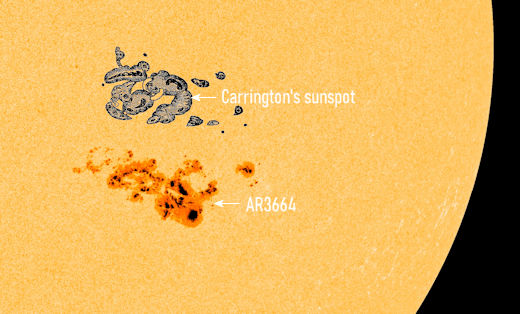
Major X4.5 solar flare erupts from Region 3663 — fourth X-class flare in 3 days - A powerful, long-duration solar flare measuring X4.5 erupted from Active Region 3663 at 06:35 UTC on May 6, 2024. The event started at 05:38 and ended at 06:47 UTC.
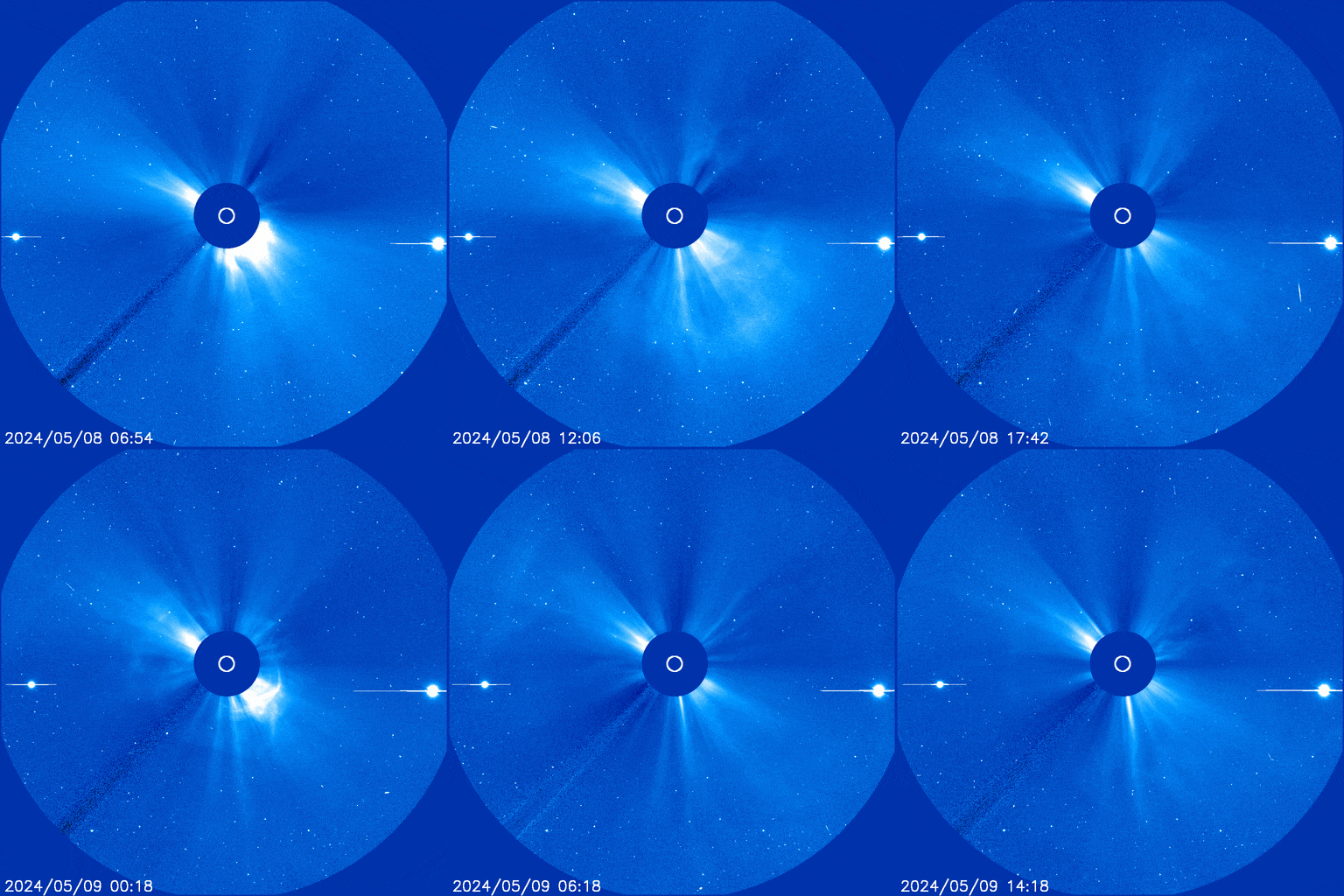
This is the 4th and the strongest X-class solar flare from Region 3663 — following X1.6 on May 3, and X1.3 and X1.2 on May 5. It is also the 3rd strongest solar flare of Solar Cycle 25 — following X6.3 on February 22, 2024, and X5.0 on December 31, 2023. No radio sweeps were observed with the event but a coronal mass ejection (CME) signature was observed in coronagraph imagery beginning at 07:12 UTC in SOHO/LASCO C2 imagery. The CME was modeled and shown to be narrow and oriented far northward of the Sun-Earth line. No Earth impacts are expected from this event. Radio frequencies were forecast to be most degraded over eastern Europe, the Middle East, NE Africa, Asia, the Indian Ocean, and the West Pacific at the time of the flare.
Strong and shallow M6.2 earthquake hits Seram, Indonesia
May 5, 2024
A strong earthquake registered by the USGS as M6.2 hit Seram, Indonesia at 18:33 UTC on May 5, 2024. The agency is reporting a depth of 12.1 km (7.5 miles). EMSC is reporting the same magnitude and depth.The epicenter was located 153.3 km (95.3 miles) WSW of Fakfak (population 18 900), and 222.9 km (138.5 miles) E of Masohi (population 36 433), Indonesia.
6 000 people are estimated to have felt strong shaking and 33 000 moderate. There is no tsunami threat from this earthquake.
Aerial footage captures aftermath of major eruptions at Ruang volcano, Indonesia - May 5, 2024
On May 5, 2024, Indonesia’s volcanology agency, PVMGB, released aerial footage of the Ruang volcano following a series of powerful eruptions that have dramatically reshaped the landscape and forced nearly 10 000 people to evacuate permanently.
Volcanic activity at Ruang rapidly increased on April 16, when the volcano experienced a series of explosive eruptions that ejected ash as high as 16.7 km (55 000 feet) above sea level. In response, the Alert Level was raised to 4, the highest possible, and the Aviation Color Code to Red. Initial evacuations saw approximately 800 residents from Ruang Island relocated for safety. However, as the situation worsened, by April 17, the evacuation zone expanded to include at least 11 000 people from both Ruang and the neighboring Tagulandang Island.


