tMoA

Would you like to react to this message? Create an account in a few clicks or log in to continue.
tMoA

~ The only Home on the Web You'll ever need ~

5 posters

    The Earthquake/Seismic Activity Log

    Carol
    Carol
    Admin
    Admin


    Posts : 31775
    Join date : 2010-04-07
    Location : Hawaii

    The Earthquake/Seismic Activity Log - Page 4 Empty Re: The Earthquake/Seismic Activity Log

    Post  Carol Mon Feb 24, 2014 8:17 am

    The Earthquake/Seismic Activity Log - Page 4 Barbados-6-5
    Recent Caribbean earthquakes spark concern
    February 2014 – CARIBBEAN – Two earthquakes greater than 5.0 have rocked the Caribbean in the last week and concerns have been growing for a major tremor in the region. On Tuesday, Feb. 18, a strong 6.5-magnitude quake occurred about 100 miles north-northeast of Bridgetown, Barbados. According to Dr. Joan Latchman, the Director of the Seismic Research Unit of the University of the West Indies, it was the strongest tremor since 1980 in the area. Three days later, on Feb. 21, a 5.1-magnitude seismic event occurred near Aruba. While both of these quakes did not cause much damage, they are a reminder that the Caribbean remains a very active seismic zone, prone to earthquakes at anytime. Earthquakes are common in the Caribbean, but most are less than 3.0 on the Richter Scale. The two recent, stronger rumbles have rekindled memories of highly destructive earthquakes over the past few hundred years. The Caribbean has a long history of destructive tremors. One of the most infamous occurred in 1692 when a 7.5-magnitude quake dismantled the city of Port Royal, Jamaica. Much of the city was submerged under water, and thousands of people lost their lives. The Caribbean Plate is sandwiched between numerous tectonic plates including the North American and South American. It is the North American that helps form the Puerto Rico Trench, with depths over 28,000 feet, north of the U.S. territory.

    This zone of subduction, where one tectonic plate slowly slide below another, is a concern to many geophysicists. While destructive quakes, such as the highly destructive Haiti tremor of 2010, have occurred recently, there has not been a major earthquake associated with the Puerto Rico Trench in over 200 years. The last event was a 8.1 tremor in 1787. According to Woods Hole Oceanographic Institution, based in Massachusetts, there have been a dozen earthquakes in the region over the past 500 years. The institution also notes that tsunamis are a concern and three quakes have been accompanied by a tsunami in Puerto Rico since 1867, the last being in 1946. With an influx of people to many islands of the Caribbean over the last few decades, much more infrastructure exists across the islands than was around throughout much of the 20th century. A major tremor and potential accompanying tsunami could cause utter destruction to populated areas and create serious economic hardship. –Accuweather


    _________________
    What is life?
    It is the flash of a firefly in the night, the breath of a buffalo in the wintertime. It is the little shadow which runs across the grass and loses itself in the sunset.

    With deepest respect ~ Aloha & Mahalo, Carol
    Carol
    Carol
    Admin
    Admin


    Posts : 31775
    Join date : 2010-04-07
    Location : Hawaii

    The Earthquake/Seismic Activity Log - Page 4 Empty Re: The Earthquake/Seismic Activity Log

    Post  Carol Mon Feb 24, 2014 8:18 am

    The Earthquake/Seismic Activity Log - Page 4 South-carolina-4-1-feb-14
    4.1 magnitude earthquake rattles South Carolina and Georgia
    February 15, 2014 – SOUTH CAROLINA – The snow and ice dumped by an unusually severe winter storm were melting, once-frigid temperatures were rising and residents of South Carolina and Georgia finally had begun to relax. Then the earth shuddered. A small earthquake shook both states late Friday, shaking homes and rattling residents hundreds of miles away. The quake happened at 10:23 p.m. and had a preliminary magnitude of 4.1, according to the U.S. Geological Survey’s website. It was centered 7 miles west of the town of Edgefield, S.C. , and was felt as far west as Atlanta and as far north as Hickory, N.C., each about 150 miles away. “It’s a large quake for that area,” said USGS geophysicist Dale Grant. “It was felt all over the place.” The U.S. Army Corps of Engineers reported two nearby dams on the Savannah River appeared to be undamaged, but planned a thorough inspection Saturday morning, Edgefield County Emergency Preparedness Director Mike Casey said. Casey said the quake was centered in a sparsely populated part of Edgefield County where there are a lot more rabbits and deer than people. He was driving around and hadn’t found any damage, but he expects some reports of minor damages to come in once the sun rises. “To get an accurate assessment we’re going to need daylight. I could be looking at damage in the dark and not know it. Tomorrow morning, I go out to get my paper and I see the bricks in my house are cracked,” Casey said. Authorities across South Carolina said their 911 centers were inundated with calls of people reporting what they thought were explosions or plane crashes as the quake’s low rumble spread across the state.

    Reports surfaced on Twitter of a leaking water tower in Augusta, Ga., following the quake, but the tower was damaged by ice from a winter storm earlier this week and not the quake, said Richmond County Sheriff’s Lt. Tangela McCorkle. No damages or injuries from the quake itself had been reported, said South Carolina Emergency Management Division spokesman Derrec Becker. The ice storm felled a lot of trees in the area, which could make it more difficult to determine what damage was caused by the quake. South Carolina Gov. Nikki Haley felt the earthquake at the governor’s mansion in Columbia. She asked the Department of Transportation to inspect bridges in the area Saturday morning as a precaution, said her spokesman Doug Mayer. Tom Clements, a resident of suburban Columbia about 60 miles east of the quake’s epicenter, said he felt the walls of his brick house shaking “and they were definitely shaking like what I’ve experienced before in Latin America” during an earthquake. Clements said he immediately went outside to see if anyone else had felt it and he found two neighbors who had. “One thought a tree had fallen” under the weight of ice dumped by the storm, he said. Earthquakes aren’t unheard of in the region. A 4.3-magnitude earthquake happened in Georgia in August 1974 several miles west of Friday’s quake. Three others of similar magnitude have been felt in South Carolina in the past 40 years, according to the USGS. The largest earthquake ever recorded on the East Coast was a 7.3-magnitude quake near Charleston in August 1886 that killed at least 60 people. –Seattle PI


    _________________
    What is life?
    It is the flash of a firefly in the night, the breath of a buffalo in the wintertime. It is the little shadow which runs across the grass and loses itself in the sunset.

    With deepest respect ~ Aloha & Mahalo, Carol
    Carol
    Carol
    Admin
    Admin


    Posts : 31775
    Join date : 2010-04-07
    Location : Hawaii

    The Earthquake/Seismic Activity Log - Page 4 Empty Re: The Earthquake/Seismic Activity Log

    Post  Carol Thu Feb 27, 2014 7:05 pm

    The Earthquake/Seismic Activity Log - Page 4 Alaska-6-1-feb-26
    6.1 magnitude earthquake strikes Alaska’s Aleutian Islands
    February 2014 – ALASKA – A 6.1 earthquake shook the Alaska communities of Nikolski and Unalaska Wednesday, according to the Alaska Earthquake Center. The strong shake occurred around noon in the Bering Sea region of the state. The center says the earthquake had a preliminary magnitude of 6.1 and was located at a depth of 23 miles. The towns, located near the mid-section of the arc of the Aleutian Islands stretching more than 1,000 miles toward Asia, reportedly didn’t suffer any damages. Quakes with magnitudes of about 4.5 or greater are strong enough to be recorded by sensitive seismographs worldwide. Great earthquakes, such as Alaska’s 1964 Good Friday earthquake, have magnitudes of 8.0 or higher. The U.S. Geological Survey says that on average, one earthquake of that size occurs somewhere in the world each year. –AD


    _________________
    What is life?
    It is the flash of a firefly in the night, the breath of a buffalo in the wintertime. It is the little shadow which runs across the grass and loses itself in the sunset.

    With deepest respect ~ Aloha & Mahalo, Carol
    Carol
    Carol
    Admin
    Admin


    Posts : 31775
    Join date : 2010-04-07
    Location : Hawaii

    The Earthquake/Seismic Activity Log - Page 4 Empty Re: The Earthquake/Seismic Activity Log

    Post  Carol Wed Mar 05, 2014 10:54 am

    The Earthquake/Seismic Activity Log - Page 4 Japan-6-5-march-2
    6.5 magnitude earthquake strikes near Nago, Japan
    March 2014 – TOKYO, Japan – A magnitude-6.6 earthquake struck south-western Japan early on Monday, the Meteorological Agency said. No casualties or damage were reported and no tsunami warning was issued. The quake jolted the region at 5:11am with its seismic centre off the north-western coast of the main Okinawa Island, at a depth of 120 kilometers, the agency said. The quake registered intensity 4 on the Japanese seismic scale of 7 in several areas of Okinawa, 1,600 kilometers south-west of Tokyo. –Gulf News


    _________________
    What is life?
    It is the flash of a firefly in the night, the breath of a buffalo in the wintertime. It is the little shadow which runs across the grass and loses itself in the sunset.

    With deepest respect ~ Aloha & Mahalo, Carol
    Carol
    Carol
    Admin
    Admin


    Posts : 31775
    Join date : 2010-04-07
    Location : Hawaii

    The Earthquake/Seismic Activity Log - Page 4 Empty Re: The Earthquake/Seismic Activity Log

    Post  Carol Mon Mar 10, 2014 8:48 am

    The Earthquake/Seismic Activity Log - Page 4 525
    Magnitude 6.9 earthquake hits 50 miles west of Eureka
    San Jose Mercury News - ‎5 hours ago‎
    A powerful magnitude-6.9 earthquake followed by aftershocks struck Sunday night off the coast of Northern California, but there were no immediate reports of injury or damage and no danger of a tsunami, officials said. The 6.9 earthquake off the coast of Northern California on Sunday night was the largest on the West Coast since the 7.2 Baja California quake in 2010. Sunday's temblor was followed by a series of at least 13 aftershocks as large as a magnitude 4.6, according to the U.S. Geological Survey. The big quake occurred at 10:18 p.m. in the Pacific Ocean 50 miles west of Eureka in Humboldt County. The USGS put the depth of the quake at about four miles.

    Several of the aftershocks were much closer to land, including one about 16 miles off the coast that registered as a magnitude 3.4. Eureka Police Department Sgt. Brian Stephens said there had been no reports of significant damage or injuries from the initial quake. "My car was rocking back and forth," Stephens, who was on out on a call when the earthquake hit, told The Times. "I thought someone was shoving my car back and forth, looked around and nobody was there. Then I realized what was happening."

    The Humboldt County Sheriff's Department also said it had no reports of injuries.

    A resident of Ferndale near Eureka, Raquel Maytorena, 52, said she felt the earthquake in her nearly 100-year-old home about a mile from the coast. "It just kept going and going, very slowly and softly. It was not violent. It almost felt like you were in a boat that was rocking," she said.

    SPECIAL REPORT: Many of L.A.'s older concrete buildings at risk. Maytorena, who said she was living in San Jose during the 1989 Loma Prieta earthquake, said this temblor "lasted longer than any earthquake I've ever felt."

    She said she felt a little rattling, but that nothing fell off the shelves and the power remained on without any interruptions. Maytorena said she also felt several aftershocks. Her 16-year-old daughter said she felt a smaller foreshock earlier in the day Sunday.
    "The animals, they felt it," Maytorena added. "My two horses were running around out by the barn, and my dogs, six dogs, were ready to get out of the house."

    Mike Meltzer of Ferndale told KTVU-TV that the quake lasted for 10 seconds. "I've been through a number of these," he said. "It wasn't a jolter; it was a wave." The USGS classified the shaking on land as "light to moderate." No tsunami warnings were issued.

    The Eureka area is considered seismically active, and there have been similar-sized quakes in the area with some regularity.
    A 6.5 quake hit the area in 2010, snapping power lines, toppling chimneys, knocking down traffic signals, shattering windows and prompting the evacuation of at least one apartment building.

    In 1964, an 8.8 earthquake in Alaska caused catastrophic damage on the North Coast.

    The March 28 tsunami killed 11 in Crescent City and destroyed the city's business district. Accounts from the time reported that fuel tanks erupted in flames while cars and trucks washed down city streets, piling up against buildings.
    By California standards, Sunday's quake was large. Two larger recent quakes occurred in remote areas: the 1999 Hector Mines temblor, magnitude 7.1, and the 1992 Landers quake, which was magnitude 7.3.

    ALSO:
    Strong winds, high surf forecast for Southern California


    http://www.latimes.com/local/lanow/la-me-ln-69-northern-california-earthquake-followed-by-aftershocks-20140310,0,4495673.story#ixzz2vZGpAwOZ


    _________________
    What is life?
    It is the flash of a firefly in the night, the breath of a buffalo in the wintertime. It is the little shadow which runs across the grass and loses itself in the sunset.

    With deepest respect ~ Aloha & Mahalo, Carol
    Carol
    Carol
    Admin
    Admin


    Posts : 31775
    Join date : 2010-04-07
    Location : Hawaii

    The Earthquake/Seismic Activity Log - Page 4 Empty Re: The Earthquake/Seismic Activity Log

    Post  Carol Mon Mar 17, 2014 7:53 pm

    The Earthquake/Seismic Activity Log - Page 4 Earthquake-7-strikes-chile.si
    7.0-magnitude quake strikes Chile
    A magnitude 7.0 earthquake has hit the Pacific coast of Chile, the US Geological Survey said. As a preventive measure, Chilean authorities have ordered a partial evacuation of the northern coastline.

    The epicentre of the quake was located 70 km northwest of Iquique in northern Chile, at a depth of 32 km, the US Geological Survey said. No injuries or damage have been reported so far.

    The National Office of Emergency of the Interior Ministry has ordered an evacuation of the coastline between the northern towns of Arica and Tocopilla, over the fears of a possible minor tsunami. The Pacific Tsunami Warning Center however said there was no tsunami expected.

    About 80,000 people were evacuated in the Tarapaca region, 3,000 in Arica and Parinacota region and 22,000 in Antofagasta region, said ONEMI's national director, Ricardo Toro, adding that the sea had risen by almost 13 inches.

    The evacuation alert was lifted several hours after the initial quake.

    Chile is located in an area of geological instability and is prone to powerful earthquakes. A major 8.8 magnitude quake hit the country back in 2010, devastating the center of the country and claiming over 500 lives.
    http://rt.com/news/earthquake-7-strikes-chile-226/

    March 2014 – CHILE – A strong quake struck off northern Chile on Sunday evening, triggering a preventive evacuation of part of the coastal area but not causing any injuries or damage to the country’s crucial copper mines. The magnitude 6.7 quake, originally measured as a 7.0, was centered 37 miles west-northwest of Iquique and hit at a depth of 12.4 miles, the U.S. Geological Survey said. The ONEMI emergency office said that preliminarily no damage or injuries had been reported after the shake, which struck at 6:16 p.m. local time (2116 GMT). Chile’s massive mines, clustered in the mineral-rich North, appeared to be fine. Collahuasi, a partnership between Glencore Xstrata and Anglo American, located in the area, said operations were normal. The Pacific Tsunami Warning Center said there was no tsunami expected. But Chile’s navy said there was a possibility of what it called “a minor tsunami,” so authorities ordered a preventive evacuation of part of the coastline after the quake. Local media showed footage of people in Iquique calmly evacuating on foot to nearby hills. A press officer at the ONEMI said sea levels in Iquique had risen a negligible 18 centimeters. The officer said it was unclear how many people had evacuated, and that it depended on each local authority when they would return to their homes. –Reuters


    Last edited by Carol on Mon Mar 17, 2014 8:01 pm; edited 1 time in total


    _________________
    What is life?
    It is the flash of a firefly in the night, the breath of a buffalo in the wintertime. It is the little shadow which runs across the grass and loses itself in the sunset.

    With deepest respect ~ Aloha & Mahalo, Carol
    Carol
    Carol
    Admin
    Admin


    Posts : 31775
    Join date : 2010-04-07
    Location : Hawaii

    The Earthquake/Seismic Activity Log - Page 4 Empty Re: The Earthquake/Seismic Activity Log

    Post  Carol Mon Mar 17, 2014 8:00 pm

    The Earthquake/Seismic Activity Log - Page 4 Earthquakes-march-15
    Planet shaken by spasm of moderate earthquakes over last 24 hours
    March 2014 – GEOLOGY – In the past 24 hours, the planet has been reeling from a series of moderate earthquakes that have erupted all across the Ring of Fire. The Ring of Fire is an area where a large number of earthquakes and volcanic eruptions occur in the basin of the Pacific Ocean. It is the most geologically-active region on the planet. In a nearly 40,000 km (25,000 mi) horseshoe shape, the region is associated with a nearly continuous series of oceanic trenches, volcanic arcs, and volcanic belts and/or plate movements. It has 452 volcanoes and is home to over 75% of the world’s active and dormant volcanoes. About 90% of the world’s earthquakes and 81% of the world’s largest earthquakes occur along the Ring of Fire. In the past 24 hours, double moderate earthquakes 5.3 and 5.6 magnitude earthquakes have struck Indonesia. A 5.4 magnitude earthquake struck NE of San Isidro Philippines. A 5.3 magnitude earthquake struck NE of the Iwo Jima Islands of Japan. A 6.1 magnitude earthquake struck South Central Peru. A 5.0 magnitude earthquake struck SE of Easter Island. A 5.4 magnitude earthquake struck SE Colombia. A 5.4 magnitude earthquake struck WSW of Santa Cruz, Chile. A 5.4 magnitude earthquake struck south of the continent of Africa. A 5.2 and 5.0 erupted along the Owen Fracture Zone, west of Africa. A 4.5 magnitude earthquake struck Greece. A 4.0 quake was reported NE of Xudat, Azerbaijan. And a 4.8 magnitude earthquake was reported ESE of Mohean, India. Tectonic plates across the globe are being perturbed by this latest burst of seismic activity which peaks around every spring equinox. People in high risk seismic regions should remain alert for the potential occurrence of large seismic events. –The Extinction Protocol


    _________________
    What is life?
    It is the flash of a firefly in the night, the breath of a buffalo in the wintertime. It is the little shadow which runs across the grass and loses itself in the sunset.

    With deepest respect ~ Aloha & Mahalo, Carol
    Carol
    Carol
    Admin
    Admin


    Posts : 31775
    Join date : 2010-04-07
    Location : Hawaii

    The Earthquake/Seismic Activity Log - Page 4 Empty Re: The Earthquake/Seismic Activity Log

    Post  Carol Mon Mar 17, 2014 8:01 pm

    The Earthquake/Seismic Activity Log - Page 4 Peru-6-3-earthquake-march-15
    6.3 magnitude earthquake strikes northern Peru
    March 2014 – PERU – A 6.3 magnitude earthquake struck the northern coast of Peru. An earthquake measuring 6.3 on the Richter scale jolted six km west of Sechura, Peru on Saturday local time, the U.S. Geological Survey (USGS) said. The epicenter, with a depth of 9.8 km, was initially determined to be at 5.566 degrees south latitude and 80.879 degrees west longitude. There have been no initial reports of damage yet. Moments later, the Kuril Islands was also shaken by light to moderate tremor. -TEP


    _________________
    What is life?
    It is the flash of a firefly in the night, the breath of a buffalo in the wintertime. It is the little shadow which runs across the grass and loses itself in the sunset.

    With deepest respect ~ Aloha & Mahalo, Carol
    Carol
    Carol
    Admin
    Admin


    Posts : 31775
    Join date : 2010-04-07
    Location : Hawaii

    The Earthquake/Seismic Activity Log - Page 4 Empty Re: The Earthquake/Seismic Activity Log

    Post  Carol Mon Mar 17, 2014 8:03 pm

    The Earthquake/Seismic Activity Log - Page 4 Los-angeles-march-17
    4.4 magnitude earthquake rattles Los Angeles: a puzzling geological oddity – fault dormant for thousands of years
    March 2014 – CALIFORNIA – The magnitude 4.4 earthquake that struck near Westwood is the most significant shake in Southern California since a 5.5 earthquake hit Chino Hills in 2008, a U.S. Geological Survey seismologist told reporters at a news conference Monday morning. Robert Graves said there have been at least six aftershocks since the 6:25 a.m. earthquake. The largest so far has been a magnitude 2.7 earthquake that struck five miles northwest of Westwood. Graves said there is always the small possibility that the 4.4 earthquake was only a prelude to an equal or stronger shake. “Always the possibility that it’s a foreshock,” Graves said, adding that about 5% of earthquakes are followed by an equal or larger shake and that if it does happen, it would occur within the next several hours. But Graves did say that “certainly we would expect more aftershocks.”Seismologists at the USGS have not yet determined exactly what fault this earthquake was on and Graves also said “we’re continuing to analyze the data, but at this point, this seems to be what I would call a rather typical earthquake.” Monday’s earthquake hit in the northern edge of the Santa Monica Mountains area, a general area responsible for the uplifting of the range over many thousands of years. “The location is somewhat surprising. It’s within the Santa Monica Mountains. We have not seen seismicity in it in recent times,” said Caltech seismologist Egill Hauksson. “It has been dormant for quite some time.” In contrast, there are well known faults to the south of the Santa Monica Mountains: the Hollywood and Santa Monica faults roughly along Hollywood and Santa Monica boulevards. Graves said people reported feeling it within about 30 to 50 miles of the epicenter, Graves said. –LA Times


    _________________
    What is life?
    It is the flash of a firefly in the night, the breath of a buffalo in the wintertime. It is the little shadow which runs across the grass and loses itself in the sunset.

    With deepest respect ~ Aloha & Mahalo, Carol
    mudra
    mudra


    Posts : 23223
    Join date : 2010-04-09
    Age : 69
    Location : belgium

    The Earthquake/Seismic Activity Log - Page 4 Empty Re: The Earthquake/Seismic Activity Log

    Post  mudra Fri Apr 11, 2014 3:47 am

    4/10/2014 — YELLOWSTONE RISES 2 INCHES IN 4 MONTHS! TWO 6.0M EARTHQUAKES HIT E. PACIFIC + OKLAHOMA SWARMING


    The Earthquake/Seismic Activity Log - Page 4 Chile-nicaragua

    Within minutes of each other, a 6.2M earthquake strikes Nicaragua , then a 6.0M strikes Chile.  Epicenters over 2,500 miles apart, reacting within minutes of each others movement.

    This new back to back 6.0M+ movement is a sign of major stress occurring along the edge of the Pacific Plate.

    Three days ago, on April 7th … we saw deep earthquakes occurring around the whole of the Pacific plate..  all occurring at a depth of roughly 300 miles (in the Asthenosphere of the Earth’s mantle).

    Particularly , I made note of a rather rare deep earthquake in Brazil.

    The deep movement led me to warn for an earthquake watch in the area NW of the Brazil event.

    Now the area just NW of the Brazil event,  Nicaragua, receives a 6.2M , immediately after this we see a 6.0M strike Chile.

    read on: http://dutchsinse.tatoott1009.com/4102014-yellowstone-rises-2-inches-in-4-months-two-6-0m-earthquakes-hit-e-pacific-oklahoma-swarming/

    Love Always
    mudra
    mudra
    mudra


    Posts : 23223
    Join date : 2010-04-09
    Age : 69
    Location : belgium

    The Earthquake/Seismic Activity Log - Page 4 Empty Re: The Earthquake/Seismic Activity Log

    Post  mudra Sun Apr 13, 2014 5:29 pm

    Through Dutchsince on Facebook

    Past 30 days of 6.0M and greater earthquakes internationally. The 7.0M off the coast of California just fell off the map (happened 32 days ago).

    Overall .. you can see... major movement is occurring. Normally, an average of 2 6.0M+ events per week.

    Normally there is ONE 8.0M+ per year... so far.. we've had 2 this year.

    Normally 1-2 earthquakes in the 7.0M range per month.. we're at 4 if you count California 32 days ago.

    Normally there are approximately 2 6.0M+ per week. We're far beyond that for this past week... now currently at FIVE 6.0M events.

    ...

    Recap. This past 7 days ...

    FIVE 6.0M+ events..

    One 7.0M+ event..

    One 8.0M+ event..

    Also, Volcanoes in Peru, Ecuador, and Guatemala fully erupted. In addition, California experienced volcanic plume activity.

    Have an earthquake plan! Don't be scared, be prepared.

    Love Always
    mudra
    Carol
    Carol
    Admin
    Admin


    Posts : 31775
    Join date : 2010-04-07
    Location : Hawaii

    The Earthquake/Seismic Activity Log - Page 4 Empty Re: The Earthquake/Seismic Activity Log

    Post  Carol Mon Apr 14, 2014 11:30 am


    SAN FRANCISCO (MarketWatch) -- A 7.6 magnitude earthquake struck near the Solomon Islands on Saturday, according to the U.S. Geological Survey. A tsunami warning was issued for the Solomon Islands, Papua New Guinea, New Caledonia and surrounding areas, according to the Pacific Tsunami Warning Center. The quake, which was downgraded from an 8.3 magnitude, was 60 miles south of Kira Kira in the Solomon Islands at a depth of 18 miles. There is no tsunami threat to Hawaii, PTWC said.


    _________________
    What is life?
    It is the flash of a firefly in the night, the breath of a buffalo in the wintertime. It is the little shadow which runs across the grass and loses itself in the sunset.

    With deepest respect ~ Aloha & Mahalo, Carol
    mudra
    mudra


    Posts : 23223
    Join date : 2010-04-09
    Age : 69
    Location : belgium

    The Earthquake/Seismic Activity Log - Page 4 Empty Re: The Earthquake/Seismic Activity Log

    Post  mudra Tue Apr 15, 2014 3:18 am

    4/15/2014 -- Global Earthquake Watch -- MAJOR Unrest -- Another 7.0M strikes

    https://www.youtube.com/watch?v=FYBto1SF6kQ


    Love Always
    mudra
    mudra
    mudra


    Posts : 23223
    Join date : 2010-04-09
    Age : 69
    Location : belgium

    The Earthquake/Seismic Activity Log - Page 4 Empty Re: The Earthquake/Seismic Activity Log

    Post  mudra Wed Apr 16, 2014 2:36 pm

    4/16/2014 -- Yellowstone Unrest -- USGS installs new seismometers to monitor -- Pros say to PREPARE

    https://www.youtube.com/watch?v=-SsAJZCU4qc


    TAT'S 2 MIN NEWS Yellowstone Unrest -- Same Time They Here You-- 4 7M & 4 9M Earthqua

    https://www.youtube.com/watch?v=SdGBV57ZyeI


    Love Always
    mudra
    mudra
    mudra


    Posts : 23223
    Join date : 2010-04-09
    Age : 69
    Location : belgium

    The Earthquake/Seismic Activity Log - Page 4 Empty Re: The Earthquake/Seismic Activity Log

    Post  mudra Sat Apr 19, 2014 4:51 pm

    Through Dutchsince of facebook

    ANOTHER 7.5M earthquake has struck Papua New Guinea !!!

    Last night there was a 6.9 (7.0).. .now today.. 7.5

    This makes Two 8.0M+ events....... SIX 7.0M+ events... and SIXTEEN 6.0M+ events in the last 3 weeks.

    http://earthquake.usgs.gov/earthquakes/eventpage/usb000pr89

    Love Always
    mudra

    Love Always
    mudra
    Carol
    Carol
    Admin
    Admin


    Posts : 31775
    Join date : 2010-04-07
    Location : Hawaii

    The Earthquake/Seismic Activity Log - Page 4 Empty Re: The Earthquake/Seismic Activity Log

    Post  Carol Wed May 07, 2014 2:16 pm

    The Earthquake/Seismic Activity Log - Page 4 Oklahoma_eq
    May 2014 – OKLAHOMA - Mile for mile, there are almost as many earthquakes rattling Oklahoma as California this year. This major increase in seismic shaking led to a rare earthquake warning today (May 5) from the U.S. Geological Survey and the Oklahoma Geological Survey. In a joint statement, the agencies said the risk of a damaging earthquake — one larger than magnitude 5.0 — has significantly increased in central Oklahoma. Geologists don’t know when or where the state’s next big earthquake will strike, nor will they put a number on the increased risk. We haven’t seen this before in Oklahoma, so we had some concerns about putting a specific number on the chances of it,” Robert Williams, a research geophysicist with the USGS Earthquake Hazards Program in Golden, Colorado, told Live Science. “But we know from other cases around the world that if you have an increasing number of small earthquakes, the chances of a larger one will go up.” That’s why earthquakes of magnitude 5 and larger are more frequent in states such as California and Alaska, where thousands of smaller temblors hit every year. This is the first time the USGS has issued an earthquake warning for a state east of the Rockies, Williams said. Such seismic hazard assessments are more typically issued for Western states following large quakes, to warn residents of the risk of damaging aftershocks, he said.

    The geological agencies took action after the rate of earthquakes in Oklahoma outpaced that of even California for the first few months of 2014. (California regained the lead in April.) “The rate of earthquakes increased dramatically in March and April,” Williams said. “That alerted us to examine this further and put out this advisory statement.” While Oklahoma’s buildings can withstand light earthquakes, the damage from a magnitude-5 temblor could be widespread. Oklahoma’s last major earthquake was in November 2011, when a magnitude-5.6 earthquake centered near Prague, Oklahoma, destroyed 14 homes and injured at least two people. “Building owners and government officials should have a special concern for older, unreinforced brick structures, which are vulnerable to serious damage during sufficient shaking,” Bill Leith, a USGS senior science adviser for earthquakes and geologic hazards, said in the joint statement. While scientists haven’t ruled out natural causes for the increase, many researchers suspect the deep injection wells used for the disposal of fracking wastewater could be causing the earthquake activity. Fracking, short for hydraulic fracturing, is a method of extracting oil and gas by cracking open underground rock.

    Ongoing studies have found a link between Oklahoma’s high-volume wastewater injection wells and regions with an uptick in earthquakes. According to the USGS, the number of quakes magnitude-3 and stronger jumped by 50 percent in the past eight months in Oklahoma. Some 183 earthquakes of magnitude 3 or greater struck between October 2013 and April 14, 2014. The state’s long-term average from 1978 to 2008 was only two earthquakes of magnitude 3.0 or larger per year. If the earthquakes are caused by wastewater injection, then the activity could continue or decrease with future changes in well usage in the state. “We don’t know if this earthquake rate is going to continue,” Williams said. “It could go to a higher rate or lower, so the increased chances of a damaging quake could change in the future.” –Yahoo News


    _________________
    What is life?
    It is the flash of a firefly in the night, the breath of a buffalo in the wintertime. It is the little shadow which runs across the grass and loses itself in the sunset.

    With deepest respect ~ Aloha & Mahalo, Carol
    Carol
    Carol
    Admin
    Admin


    Posts : 31775
    Join date : 2010-04-07
    Location : Hawaii

    The Earthquake/Seismic Activity Log - Page 4 Empty Re: The Earthquake/Seismic Activity Log

    Post  Carol Wed May 07, 2014 2:17 pm

    The Earthquake/Seismic Activity Log - Page 4 Thailand-6-0-may-5-2014
    6.0 magnitude earthquake strikes Thailand, leaving 1 dead
    May 2014 – THAILAND – Officials said Tuesday that one person was killed and several dozen were hurt in an earthquake that struck northern Thailand and Myanmar a day earlier, smashing windows, cracking walls and roads and damaging Buddhist temples. The airport in Chiang Rai, a northern Thai city near the epicenter of the shallow magnitude 6.0 temblor, evacuated people from its terminal, where display signs and pieces of the ceiling fell. There was no damage to the runway or flight disruptions, airport General Manager Damrong Klongakara said. A well-known temple near the city, the all-white Wat Rongkhun, was closed due to safety concerns after the earthquake. “The spire of the main building came off and the tiles on the roof fell off,” Chalermchai Kositpiphat, the artist who designed the temple, told Nation TV. “I still don’t know how we can sleep tonight. … It was shaking the whole time and then aftershocks followed four to five times.” Anusorn Kaewkangwan, the deputy director-general of the Disaster Prevention and Mitigation Department told The Associated Press on Tuesday that an 83-year-old woman in Chiang Rai’s Mae Lao district was killed when the brick walls of her house collapsed onto her during the quake. Anusorn said about 25 people were slightly injured, mostly from fallen ceilings or items in their houses.

    Thailand’s Meteorological Department said the quake was magnitude 6.3. The U.S. Geological Survey measured it at 6.0 and said the epicenter was 9 kilometers (6 miles) south of Mae Lao and 27 kilometers (17 miles) southwest of Chiang Rai. Its depth was a relatively shallow 7.4 kilometers (4.6 miles). Shallow quakes often cause more damage. The quake was followed by several moderate aftershocks. Southeast Asia is seismically active and quakes are often felt in surrounding nations. Thailand has several faults, though in recent times quakes centered in the country have been less severe than those in other Southeast Asian nations, such as Myanmar and Indonesia. A 9.1-magnitude earthquake off Indonesia’s Sumatra Island on Dec. 26, 2004, triggered an Indian Ocean tsunami that killed more than 8,000 people in Thailand’s coastal areas, among its overall death toll of 240,000. The last earthquake in Thailand approaching the size of Monday’s quake registered magnitude 5.1 on Dec. 13, 2006, in Chiang Mai province. –ABC News


    _________________
    What is life?
    It is the flash of a firefly in the night, the breath of a buffalo in the wintertime. It is the little shadow which runs across the grass and loses itself in the sunset.

    With deepest respect ~ Aloha & Mahalo, Carol
    Carol
    Carol
    Admin
    Admin


    Posts : 31775
    Join date : 2010-04-07
    Location : Hawaii

    The Earthquake/Seismic Activity Log - Page 4 Empty Re: The Earthquake/Seismic Activity Log

    Post  Carol Wed May 07, 2014 2:18 pm

    Twin 6 magnitude earthquakes shake seafloor south of Fiji
    Fiji 6.6 May 4 2014
    May 2014 – FIJI - A 6.6-magnitude and another 6.1- magnitude undersea earthquakes jolted south of Fiji late Sunday, the United States Geological Survey (USGS) said. The epicenter of the first quake, a 6.6-magnitude one which struck from a depth of 527.6 kilometers at 9:15 p.m. local time ( 0915 GMT), was traced 722 kilometers south of the Fijian capital of Suva, USGS data showed. The agency had initially reported the quake at 6.8 magnitude. The epicenter of the second quake, a 6.1-magnitude one which struck from a depth of 610.6 kilometers at 9:25 p.m. local time ( 0925 GMT), was traced 848 kilometers south of Suva. The Hawaii-based Pacific Tsunami Warning Center did not immediately issue a tsunami warning based on the two quakes, and there were no immediate reports of casualty or damage. Fiji lies on the so-called Pacific “Ring of Fire,” an arc of earthquake and volcanic zones where continental plates collide producing frequent seismic activity. –Shanghai Daily


    _________________
    What is life?
    It is the flash of a firefly in the night, the breath of a buffalo in the wintertime. It is the little shadow which runs across the grass and loses itself in the sunset.

    With deepest respect ~ Aloha & Mahalo, Carol
    Carol
    Carol
    Admin
    Admin


    Posts : 31775
    Join date : 2010-04-07
    Location : Hawaii

    The Earthquake/Seismic Activity Log - Page 4 Empty Re: The Earthquake/Seismic Activity Log

    Post  Carol Mon May 12, 2014 10:28 am

    The Earthquake/Seismic Activity Log - Page 4 650x366_05051314_165162211

    May 2014 – TOKYO, JAPAN - A magnitude 6.0 earthquake struck early Monday morning about 60 miles south of Tokyo. The quake, which occurred at 5:18 a.m., local time, was felt across the highly populated Greater Tokyo Area. Widespread shaking was reported; however, there have been no reports of major damage in the region. Initial reports indicate that 17 people suffered injuries during the quake, mainly from falling caused by the quake, according to Associated Press. Many trains were delayed following the quake, while some speed restrictions were temporally placed on expressways in the affected areas. No tsunami was reported following the earthquake along the Japan coastline, and no warnings were issued.
     A national broadcaster out of Japan stated that this was the strongest earthquake felt in Tokyo since the deadly 9.0 quake that caused a massive tsunami in March 2011. No damage or abnormalities were reported at the Fukushima Dai-Ichi nuclear plant, which was heavily damaged during the 2011 event. A separate 6.0 magnitude earthquake rattled northern Thailand on Monday. The earthquake is being blamed for at least 1 death due to a home collapsing on an elderly woman. About 25 other people reported varying injuries associated with the earthquake. The quake led to smashed windows and cracked walls in many structures, including several Buddhist temples, according to the Associated Press. Reports across the north of Thailand also include damaged roadways. Daily showers and thunderstorms will impact any cleanup efforts across the region through the middle of the week. –Accuweather


    _________________
    What is life?
    It is the flash of a firefly in the night, the breath of a buffalo in the wintertime. It is the little shadow which runs across the grass and loses itself in the sunset.

    With deepest respect ~ Aloha & Mahalo, Carol
    Carol
    Carol
    Admin
    Admin


    Posts : 31775
    Join date : 2010-04-07
    Location : Hawaii

    The Earthquake/Seismic Activity Log - Page 4 Empty Re: The Earthquake/Seismic Activity Log

    Post  Carol Mon May 12, 2014 10:29 am

    Powerful earthquake shakes Mexico City; workers evacuate buildings


    The Earthquake/Seismic Activity Log - Page 4 Mexico-6-4-may-8-2014

    May 2014 – MEXICO CITY — A strong earthquake on the Pacific coast of Mexico shook the capital on Thursday, sending frightened office workers streaming into the streets away from high-rise buildings. The 6.4-magnitude temblor in southern Guerrero state had an epicenter about 9 miles (15 kilometers) north of Tecpan de Galeana and about 171 miles (277 kilometers) southwest of Mexico City, according to the U.S. Geological Survey. There were no immediate reports of injuries or damage. The quake had a depth of 23 kilometers. There was only mild shaking in the resort city of Acapulco, according to an Associated Press reporter there. The USGS downgraded the magnitude from 6.8. Carmen Lopez, an elegantly dressed businesswoman from Michoacan, was leaving a downtown Mexico City office building when the ground began to sway. She dashed across the street to a leafy median as light poles swayed violently above her.


    “That was just too scary,” said Lopez, as she quickly started dialing her cell phone to alert friends and family. Behind her, thousands of people poured out from neighboring office buildings, following pre-planned evacuation routes to areas considered safe from any potential of falling glass. Mexico City is vulnerable to distant earthquakes because much of it sits atop the muddy sediments of drained lake beds. They jiggle like jelly when the quake waves hit. A 7.2-magnitude quake with an epicenter about 40 miles (66 kilometers) from Thursday’s quake shook central and southern Mexico on April 18. A magnitude-8.1 quake that killed at least 6,000 people and destroyed many buildings in Mexico City in 1985 was centered 400 kilometers away on the Pacific Coast. -CTV


    _________________
    What is life?
    It is the flash of a firefly in the night, the breath of a buffalo in the wintertime. It is the little shadow which runs across the grass and loses itself in the sunset.

    With deepest respect ~ Aloha & Mahalo, Carol
    Carol
    Carol
    Admin
    Admin


    Posts : 31775
    Join date : 2010-04-07
    Location : Hawaii

    The Earthquake/Seismic Activity Log - Page 4 Empty Re: The Earthquake/Seismic Activity Log

    Post  Carol Tue Jun 03, 2014 8:43 pm

    6.2 magnitude earthquake strikes off west coast of Mexico
    Posted on May 31, 2014by The Extinction Protocol
    The Earthquake/Seismic Activity Log - Page 4 Mexico-off-coast-may-31-2014-6-2
    May 2014 – MEXICO – A strong 6.2-magnitude undersea earthquake struck off the coast of Mexico Saturday, US seismologists said. The US Geological Survey said the quake occurred around 11:53 am GMT and was located about 184 miles (295 kilometers) southwest of the coastal resort city of Puerto Vallarta. They had earlier put the quake’s magnitude at 6.6. The tremor was reportedly felt as far away as the popular Mexican resort region of Cabo San Lucas.


    _________________
    What is life?
    It is the flash of a firefly in the night, the breath of a buffalo in the wintertime. It is the little shadow which runs across the grass and loses itself in the sunset.

    With deepest respect ~ Aloha & Mahalo, Carol
    Carol
    Carol
    Admin
    Admin


    Posts : 31775
    Join date : 2010-04-07
    Location : Hawaii

    The Earthquake/Seismic Activity Log - Page 4 Empty Re: The Earthquake/Seismic Activity Log

    Post  Carol Mon Jun 23, 2014 5:59 pm

    Alaska: Tsunami warning issued after 8.0 quake off Aleutian Islands
    Natasha Ruppert, a seismologist with the Alaska Earthquake Center, said the communities that would have suffered damage are also under tsunami warnings, so people may not have been able to get out and check for damage yet.


    _________________
    What is life?
    It is the flash of a firefly in the night, the breath of a buffalo in the wintertime. It is the little shadow which runs across the grass and loses itself in the sunset.

    With deepest respect ~ Aloha & Mahalo, Carol
    mudra
    mudra


    Posts : 23223
    Join date : 2010-04-09
    Age : 69
    Location : belgium

    The Earthquake/Seismic Activity Log - Page 4 Empty Re: The Earthquake/Seismic Activity Log

    Post  mudra Tue Jun 24, 2014 4:41 pm

    Carol wrote:Alaska: Tsunami warning issued after 8.0 quake off Aleutian Islands
    Natasha Ruppert, a seismologist with the Alaska Earthquake Center, said the communities that would have suffered damage are also under tsunami warnings, so people may not have been able to get out and check for damage yet.

    6/23/2014 -- 8.0M Earthquake and Tsunami strike Alaska -- Aleutian Islands Pacific Warning

    https://www.youtube.com/watch?v=9xVCh9rfz50


    Love Always
    mudra
    Carol
    Carol
    Admin
    Admin


    Posts : 31775
    Join date : 2010-04-07
    Location : Hawaii

    The Earthquake/Seismic Activity Log - Page 4 Empty Re: The Earthquake/Seismic Activity Log

    Post  Carol Sat Jul 05, 2014 10:55 pm

    Mysterious earthquake ‘swarm’ near Noatak Alaska continues, puzzling scientists
    Posted on July 6, 2014by The Extinction Protocol
    The Earthquake/Seismic Activity Log - Page 4 Screen-Shot-2014-05-03-at-11.34.36
    July 2014 – ALASKA - Another powerful earthquake shook the Northwest Arctic earlier this month. It is the fourth magnitude 5.5 quake to rock the region in six weeks. Like the previous three, last Friday’s episode was initiated about 10 miles from Noatak and was measured at a depth of 10 miles. “The whole house shook,” said Herbert Walton, the tribal administrator in Noatak. “We’re concerned.” Walton said there was no major damage or injuries that he was aware of, though the first set of quakes in mid-April did cause a few cracks in the IRA building. “There are plenty of people wondering if there is going to be a bigger one, because every time it happens, they seem to be getting bigger,” Walton said. The first two quakes happened on April 18, while the third shook the area on May 3. All four were about the same magnitude and are now being referred to as an “earthquake swarm,” said Mike West, a seismologist with the Alaska Earthquake Center. The four major quakes have been accompanied by more than 250 “unusually vigorous” aftershocks, West said. “They all have the same cause; the same fault motion,” he said. “And they occur in more or less the same place.” West said vigorous aftershocks are not uncommon, but normally they simmer down over time. The fact that this series of shakes is not losing strength is part of the reason scientists are referring to the occurrences as a swarm, rather than a sequence.
    The Earthquake/Seismic Activity Log - Page 4 Images?q=tbn:ANd9GcTtSnAb3jZxttIBE8JYikLwjsx6c7nFRG5JO2gNmu7s8v2vxtzo1Q
    Earthquakes relieve pressure in the earth, and because these strong quakes and aftershocks are still happening, that tells experts that the stress was not fully relieved with the first set of quakes. “In an area like Noatak, this is very unusual behavior,” West said. Swarms are more common around volcanoes and geothermal sites, but since there are neither in the area in question, West said seismologists are scratching their heads trying to find a comparable episode in mainland Alaska. Last month, technicians traveled to Kotzebue and Noatak where they held public information meetings and installed temporary seismic stations in both communities. The instruments will allow scientists to better understand what exactly is happening and record all the aftershocks, even the less jarring ones. “Those two stations are behaving perfectly,” West said. “The difference is that we know far more about the earthquake Friday night than we do about the ones in April.” For example, they can now trust the depth reading, and are closer to understanding the orientation of the fault by detecting the smaller aftershocks, all of which is valuable in figuring out why these earthquakes are happening. Experts also know that the fault line spans about 19 miles.


    What seismologists still don’t know is whether or not a bigger earthquake is on the horizon. “There is nothing to suggest a larger earthquake; earthquake swarms are characterized by earthquakes of the same size,” West said. “But I would be lying if I said there’s no possibility of a larger earthquake.” There is no evidence to suggest that the quakes will grow in size, he reiterated. “It’s a very tricky subject. This is a very unusual situation,” West said. Because this is new territory as far as recorded seismic data, those studying the quakes have nothing to compare information to, leaving them limited as far as what they can tell the general public. As for those in Noatak, Walton said, they are still wondering what all these quakes mean. And each time the ground rumbles, locals are getting calls from surrounding villages asking the same question. Last month, the town meeting in Noatak with the technician from the Alaska Earthquake Center was full with curious locals, but experts are limited on what they can explain because they simply don’t know why it’s happening or if it will continue. “This is a significant thing and it’s a challenge to raise awareness without becoming alarmist,” West said. –Alaska Dispatch


    Scientists say the number of big earthquakes have doubled in 2014 – though cause remains elusive
    Posted on July 6, 2014
    by The Extinction Protocol
    The Earthquake/Seismic Activity Log - Page 4 Terremotos-anonimos5
    July 2014 – GEOLOGY – If you think there have been more earthquakes than usual this year, you’re right. A new study finds there were more than twice as many big earthquakes in the first quarter of 2014 as compared with the average since 1979. “We have recently experienced a period that has had one of the highest rates of great earthquakes ever recorded,” said lead study author Tom Parsons, a research geophysicist with the U.S. Geological Survey (USGS) in Menlo Park, California. But even though the global earthquake rate is on the rise, the number of quakes can still be explained by random chance, said Parsons and co-author Eric Geist, also a USGS researcher. Their findings were published online June 21 in the journal Geophysical Research Letters. With so many earthquakes rattling the planet in 2014, Parsons actually hoped he might find the opposite — that the increase in big earthquakes comes from one large quake setting off another huge shaker. Earlier research has shown that seismic waves from one earthquake can travel around the world and trigger tiny temblors elsewhere. “As our group has been interested in the ability of an earthquake to affect others at a global scale, we wondered if we were seeing it happening. I really expected we would see evidence of something we couldn’t explain by randomness,” Parsons told Live Science’s Our Amazing Planet in an email interview.
    The new study isn’t the first time researchers have tried and failed to link one earthquake to another in time and across distance. Earlier studies found that the biggest earthquakes on the planet — the magnitude-8 and magnitude-9 quakes — typically trigger much smaller jolts, tiny magnitude-2 and magnitude-3 rumblers. Yet, no one has ever proven that large quakes unleash other large quakes. Finding a statistical connection between big earthquakes is a step toward proving such connections takes place. But despite the recent earthquake storm, the world’s great earthquakes still seem to strike at random, the new study found. The average rate of big earthquakes — those larger than magnitude 7 — has been 10 per year since 1979, the study reports. That rate rose to 12.5 per year starting in 1992, and then jumped to 16.7 per year starting in 2010 — a 65 percent increase compared to the rate since 1979. This increase accelerated in the first three months of 2014 to more than double the average since 1979, the researchers report. The rise in earthquakes is statistically similar to the results of flipping a coin, Parsons said: Sometimes heads or tails will repeat several times in a row, even though the process is random.


    “Basically, we can’t prove that what we saw during the first part of 2014, as well as since 2010, isn’t simply a similar thing to getting six tails in a row,” he said. But Parsons said the statistical findings don’t rule out the possibility that the largest earthquakes may trigger one another across great distances. Researchers may simply lack the data to understand such global “communication,” he said. “It’s possible that global-level communications happen so infrequently that we haven’t seen enough to find it among the larger, rarer events,” Parsons said. However, earthquakes smaller than magnitude-5.6 do cluster on a global scale, the researchers found. This suggests these less-powerful quakes are more likely to be influenced by others — a finding borne out by previous research. For example, the number of magnitude-5 earthquakes surged after the catastrophic magnitude-9 earthquakes in Japan and Sumatra, even at distances greater than 620 miles (1,000 kilometers), earlier studies found. –Yahoo News


    _________________
    What is life?
    It is the flash of a firefly in the night, the breath of a buffalo in the wintertime. It is the little shadow which runs across the grass and loses itself in the sunset.

    With deepest respect ~ Aloha & Mahalo, Carol
    Carol
    Carol
    Admin
    Admin


    Posts : 31775
    Join date : 2010-04-07
    Location : Hawaii

    The Earthquake/Seismic Activity Log - Page 4 Empty Re: The Earthquake/Seismic Activity Log

    Post  Carol Sun Aug 03, 2014 9:30 am

    Magnitude 6.9 Earthquake in Mexico
    Tectonic Summary
    The July 7, 2014 M 6.9 earthquake near the coast of Chiapas, Mexico occurred as the result of normal faulting at a depth of 60 km. The earthquake occurred near the border between Mexico and Guatemala, near Puero Madero, Mexico, and about 200 km from Guatemala City, Guatemala, which has a population of one million people. At the location of the earthquake, the Cocos plate subducts to the northeast beneath the North America plate at a velocity of approximately 79 mm/yr, forming the Middle America subduction zone. The mechanism of the earthquake is consistent with extension within the down-going Cocos slab. The earthquake occurred below and to the east of the slab interface where larger, thrust-type earthquakes can occur.
    The region around the July 7 earthquake is highly seismically active, having produced 12 events of M7.0 or greater since 1902 within 200 km of the epicenter. Most recently, an M7.4 event occurred in November 2012 on the subduction zone interface 123 km southeast of the July 7 event. Other notable events include an M7.2 in 1993 which caused 1 casualty in western Guatemala; an M7.7 in 1942 with 38 casualties and widespread damage, and two events of M7.8 and 7.5 in 1902.
    Seismotectonics of the Caribbean Region and Vicinity

    Extensive diversity and complexity of tectonic regimes characterizes the perimeter of the Caribbean plate, involving no fewer than four major plates (North America, South America, Nazca, and Cocos). Inclined zones of deep earthquakes (Wadati-Benioff zones), ocean trenches, and arcs of volcanoes clearly indicate subduction of oceanic lithosphere along the Central American and Atlantic Ocean margins of the Caribbean plate, while crustal seismicity in Guatemala, northern Venezuela, and the Cayman Ridge and Cayman Trench indicate transform fault and pull-apart basin tectonics.
    Along the northern margin of the Caribbean plate, the North America plate moves westwards with respect to the Caribbean plate at a velocity of approximately 20 mm/yr. Motion is accommodated along several major transform faults that extend eastward from Isla de Roatan to Haiti, including the Swan Island Fault and the Oriente Fault. These faults represent the southern and northern boundaries of the Cayman Trench. Further east, from the Dominican Republic to the Island of Barbuda, relative motion between the North America plate and the Caribbean plate becomes increasingly complex and is partially accommodated by nearly arc-parallel subduction of the North America plate beneath the Caribbean plate. This results in the formation of the deep Puerto Rico Trench and a zone of intermediate focus earthquakes (70-300 km depth) within the subducted slab. Although the Puerto Rico subduction zone is thought to be capable of generating a megathrust earthquake, there have been no such events in the past century. The last probable interplate (thrust fault) event here occurred on May 2, 1787 and was widely felt throughout the island with documented destruction across the entire northern coast, including Arecibo and San Juan. Since 1900, the two largest earthquakes to occur in this region were the August 4, 1946 M8.0 Samana earthquake in northeastern Hispaniola and the July 29, 1943 M7.6 Mona Passage earthquake, both of which were shallow thrust fault earthquakes. A significant portion of the motion between the North America plate and the Caribbean plate in this region is accommodated by a series of left-lateral strike-slip faults that bisect the island of Hispaniola, notably the Septentrional Fault in the north and the Enriquillo-Plantain Garden Fault in the south. Activity adjacent to the Enriquillo-Plantain Garden Fault system is best documented by the devastating January 12, 2010 M7.0 Haiti strike-slip earthquake, its associated aftershocks and a comparable earthquake in 1770.
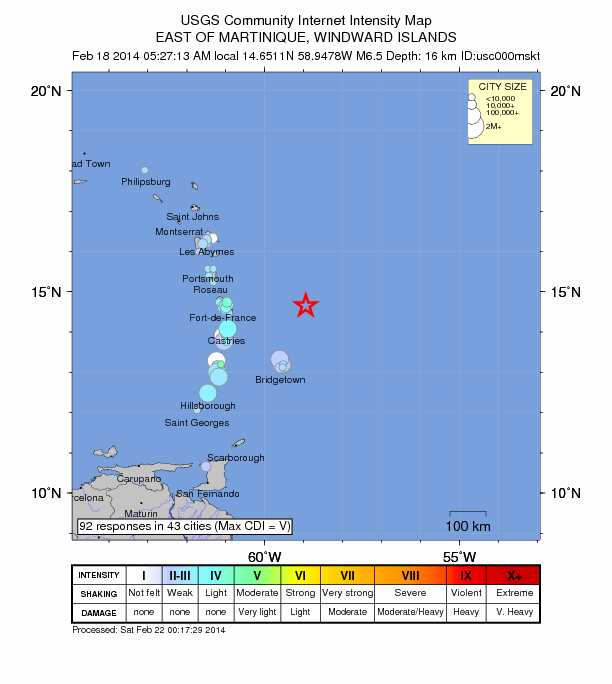
    Moving east and south, the plate boundary curves around Puerto Rico and the northern Lesser Antilles where the plate motion vector of the Caribbean plate relative to the North and South America plates is less oblique, resulting in active island-arc tectonics. Here, the North and South America plates subduct towards the west beneath the Caribbean plate along the Lesser Antilles Trench at rates of approximately 20 mm/yr. As a result of this subduction, there exists both intermediate focus earthquakes within the subducted plates and a chain of active volcanoes along the island arc. Although the Lesser Antilles is considered one of the most seismically active regions in the Caribbean, few of these events have been greater than M7.0 over the past century. The island of Guadeloupe was the site of one of the largest megathrust earthquakes to occur in this region on February 8, 1843, with a suggested magnitude greater than 8.0. The largest recent intermediate-depth earthquake to occur along the Lesser Antilles arc was the November 29, 2007 M7.4 Martinique earthquake northwest of Fort-De-France.
    The southern Caribbean plate boundary with the South America plate strikes east-west across Trinidad and western Venezuela at a relative rate of approximately 20 mm/yr. This boundary is characterized by major transform faults, including the Central Range Fault and the Boconó-San Sebastian-El Pilar Faults, and shallow seismicity. Since 1900, the largest earthquakes to occur in this region were the October 29, 1900 M7.7 Caracas earthquake, and the July 29, 1967 M6.5 earthquake near this same region. Further to the west, a broad zone of compressive deformation trends southwestward across western Venezuela and central Columbia. The plate boundary is not well defined across northwestern South America, but deformation transitions from being dominated by Caribbean/South America convergence in the east to Nazca/South America convergence in the west. The transition zone between subduction on the eastern and western margins of the Caribbean plate is characterized by diffuse seismicity involving low- to intermediate-magnitude (M<6.0) earthquakes of shallow to intermediate depth.
    The plate boundary offshore of Colombia is also characterized by convergence, where the Nazca plate subducts beneath South America towards the east at a rate of approximately 65 mm/yr. The January 31, 1906 M8.5 earthquake occurred on the shallowly dipping megathrust interface of this plate boundary segment. Along the western coast of Central America, the Cocos plate subducts towards the east beneath the Caribbean plate at the Middle America Trench. Convergence rates vary between 72-81 mm/yr, decreasing towards the north. This subduction results in relatively high rates of seismicity and a chain of numerous active volcanoes; intermediate-focus earthquakes occur within the subducted Cocos plate to depths of nearly 300 km. Since 1900, there have been many moderately sized intermediate-depth earthquakes in this region, including the September 7, 1915 M7.4 El Salvador and the October 5, 1950 M7.8 Costa Rica events.

    The boundary between the Cocos and Nazca plates is characterized by a series of north-south trending transform faults and east-west trending spreading centers. The largest and most seismically active of these transform boundaries is the Panama Fracture Zone. The Panama Fracture Zone terminates in the south at the Galapagos rift zone and in the north at the Middle America trench, where it forms part of the Cocos-Nazca-Caribbean triple junction. Earthquakes along the Panama Fracture Zone are generally shallow, low- to intermediate in magnitude (M<7.2) and are characteristically right-lateral strike-slip faulting earthquakes. Since 1900, the largest earthquake to occur along the Panama Fracture Zone was the July 26, 1962 M7.2 earthquake.


    References for the Panama Fracture Zone: 
    Molnar, P., and Sykes, L. R., 1969, Tectonics of the Caribbean and Middle America Regions from Focal Mechanisms and Seismicity: Geological Society of America Bulletin, v. 80, p. 1639-1684.
    More information on regional seismicity and tectonics


    Last edited by Carol on Sun Aug 10, 2014 12:21 pm; edited 1 time in total


    _________________
    What is life?
    It is the flash of a firefly in the night, the breath of a buffalo in the wintertime. It is the little shadow which runs across the grass and loses itself in the sunset.

    With deepest respect ~ Aloha & Mahalo, Carol

      Current date/time is Mon May 13, 2024 3:16 am