tMoA

Would you like to react to this message? Create an account in a few clicks or log in to continue.
tMoA

~ The only Home on the Web You'll ever need ~

+21
Aquaries1111
giovonni
arvan33
Floyd
lawlessline
JesterTerrestrial
THEeXchanger
newel
Brook
greybeard
Mercuriel
Sanicle
devakas
hobbit
mudra
burgundia
lindabaker
LeeEllisMusic
MargueriteBee
Carol
HigherLove
25 posters

    The Earthquake/Seismic Activity Log

    HigherLove
    HigherLove


    Posts : 2357
    Join date : 2011-01-27
    Age : 58

    The Earthquake/Seismic Activity Log Empty The Earthquake/Seismic Activity Log

    Post  HigherLove Thu Apr 07, 2011 1:53 pm

    The Earthquake/Seismic Activity Log TopMap.eveday
    HEADLINES: 7.4 Napal


    - Learn more about volcanoes! Easy-to-understand e-Book:  http://pubs.usgs.gov/gip/volc/cover2.html  
    -  Generate and study your own seismic waves -   http://aspire.cosmic-ray.org/labs/seismic/index.htm


    Last edited by Carol on Tue May 12, 2015 9:50 am; edited 255 times in total (Reason for editing : Frequent updates)
    HigherLove
    HigherLove


    Posts : 2357
    Join date : 2011-01-27
    Age : 58

    The Earthquake/Seismic Activity Log Empty Related threads in The Mists

    Post  HigherLove Thu Apr 07, 2011 3:34 pm

    The Earthquake/Seismic Activity Log 10090410


    Last edited by HigherLove on Fri Feb 24, 2012 4:57 pm; edited 14 times in total
    HigherLove
    HigherLove


    Posts : 2357
    Join date : 2011-01-27
    Age : 58

    The Earthquake/Seismic Activity Log Empty Re: The Earthquake/Seismic Activity Log

    Post  HigherLove Thu Apr 07, 2011 3:46 pm

    April 7, 2011

    I will add in updates as they appear:
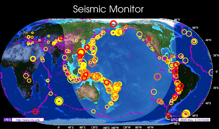
    http://quakes.globalincidentmap.com/


    Friday April 8 2011, 01:27:14 UTC 13 minutes ago Southern California 1.4 22.6 Detail
    Friday April 8 2011, 00:56:53 UTC 44 minutes ago Banda Sea 5.0 248.9 Detail
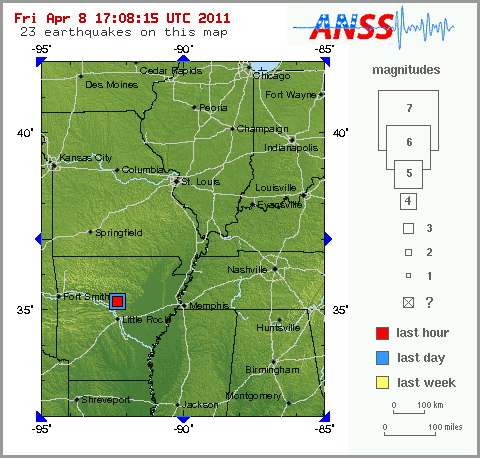
    Friday April 8 2011, 00:28:24 UTC 72 minutes ago Arkansas 2.9 2.2 Detail
    Friday April 8 2011, 00:28:22 UTC 72 minutes ago Arkansas 2.9 5.0 Detail
    Friday April 8 2011, 00:28:22 UTC 72 minutes ago Arkansas 2.9 5.0 Detail
    Thursday April 7 2011, 23:37:07 UTC 2 hours ago Puerto Rico 2.7 40.0 Detail
    Thursday April 7 2011, 23:11:45 UTC 2 hours ago Central California 1.0 7.3 Detail
    Thursday April 7 2011, 23:11:09 UTC 2 hours ago Arkansas 3.9 6.1 Detail
    Thursday April 7 2011, 23:11:09 UTC 2 hours ago Arkansas 4.0 2.6 Detail
    Thursday April 7 2011, 22:41:50 UTC 2 hours ago Central California 1.3 7.9 Detail
    Thursday April 7 2011, 22:39:41 UTC 3 hours ago Northern California 2.4 3.1 Detail
    Thursday April 7 2011, 22:35:03 UTC 3 hours ago Southern California 1.4 9.1 Detail
    Thursday April 7 2011, 22:27:35 UTC 3 hours ago Central California 1.3 3.4 Detail
    Thursday April 7 2011, 22:17:41 UTC 3 hours ago Southern California 1.4 4.9 Detail
    Thursday April 7 2011, 22:15:46 UTC 3 hours ago Central California 1.3 9.2 Detail
    Thursday April 7 2011, 22:02:19 UTC 3 hours ago near the east coast of Honshu, Japan 5.2 34.0 Detail
    Thursday April 7 2011, 22:01:03 UTC 3 hours ago Northern California 1.2 3.6 Detail
    Thursday April 7 2011, 21:49:34 UTC 3 hours ago Island of Hawaii, Hawaii 3.0 35.1 Detail
    Thursday April 7 2011, 21:33:20 UTC 4 hours ago Greater Los Angeles area, California 1.5 15.9 Detail
    Thursday April 7 2011, 21:15:18 UTC 4 hours ago Southern California 1.1 17.2 Detail
    Thursday April 7 2011, 21:06:05 UTC 4 hours ago north of Honduras 5.0 16.2 Detail
    Thursday April 7 2011, 20:41:54 UTC 4 hours ago north of Honduras 5.8 19.5 Detail
    Thursday April 7 2011, 19:58:17 UTC 5 hours ago Island of Hawaii, Hawaii 2.5 5.7 Detail
    Thursday April 7 2011, 19:31:07 UTC 6 hours ago Central California 1.7 5.5 Detail
    Thursday April 7 2011, 19:03:03 UTC 6 hours ago Northern California 1.3 8.4 Detail
    Thursday April 7 2011, 19:02:29 UTC 6 hours ago Central California 1.0 8.0 Detail
    Thursday April 7 2011, 19:00:01 UTC 6 hours ago Central California 1.0 0.8 Detail
    Thursday April 7 2011, 18:53:23 UTC 6 hours ago Central Alaska 2.1 10.5 Detail
    Thursday April 7 2011, 18:53:23 UTC 6 hours ago Central Alaska 2.1 10.5 Detail
    Thursday April 7 2011, 18:51:26 UTC 6 hours ago Central California 2.5 6.0 Detail
    Thursday April 7 2011, 18:36:08 UTC 7 hours ago Central California 1.8 9.0 Detail
    Thursday April 7 2011, 18:22:16 UTC 7 hours ago Central California 1.8 10.8 Detail
    Thursday April 7 2011, 18:12:36 UTC 7 hours ago Southern California 1.3 0.0 Detail
    Thursday April 7 2011, 17:51:58 UTC 7 hours ago Northern California 1.0 1.9 Detail
    Thursday April 7 2011, 17:45:01 UTC 7 hours ago Island of Hawaii, Hawaii 1.9 35.7 Detail
    Thursday April 7 2011, 17:40:21 UTC 8 hours ago Central Alaska 2.0 7.2 Detail
    Thursday April 7 2011, 17:06:47 UTC 8 hours ago Northern California 2.4 6.4 Detail
    Thursday April 7 2011, 16:57:04 UTC 8 hours ago Central Alaska 1.7 3.3 Detail
    Thursday April 7 2011, 16:57:04 UTC 8 hours ago Central Alaska 1.7 3.5 Detail
    Thursday April 7 2011, 16:44:29 UTC 8 hours ago Central California 1.1 6.0 Detail
    Thursday April 7 2011, 16:40:50 UTC 9 hours ago Central Alaska 4.4 119.2 Detail
    Thursday April 7 2011, 16:40:50 UTC 9 hours ago Central Alaska 4.4 123.0 Detail
    Thursday April 7 2011, 16:39:03 UTC 9 hours ago Central California 2.9 4.8 Detail
    Thursday April 7 2011, 16:39:03 UTC 9 hours ago Central California 2.9 5.0 Detail
    Thursday April 7 2011, 16:31:03 UTC 9 hours ago Southeastern Alaska 1.6 17.9 Detail
    Thursday April 7 2011, 16:06:43 UTC 9 hours ago Southern Alaska 2.4 27.8 Detail
    Thursday April 7 2011, 15:35:25 UTC 10 hours ago Utah 1.7 11.1 Detail
    Thursday April 7 2011, 15:31:28 UTC 10 hours ago near the east coast of Honshu, Japan 4.6 67.2 Detail
    Thursday April 7 2011, 15:25:13 UTC 10 hours ago near the east coast of Honshu, Japan 4.6 67.0 Detail
    Thursday April 7 2011, 15:17:50 UTC 10 hours ago Central California 2.2 11.5 Detail
    Thursday April 7 2011, 14:40:56 UTC 10 hours ago Greater Los Angeles area, California 1.6 8.3 Detail
    Thursday April 7 2011, 14:32:41 UTC 11 hours ago near the east coast of Honshu, Japan 7.1 49.0 Detail
    Thursday April 7 2011, 14:32:35 UTC 11 hours ago Central California 1.1 4.6 Detail
    Thursday April 7 2011, 14:32:00 UTC 11 hours ago near the east coast of Honshu, Japan 7.4 40.0 Detail
    Thursday April 7 2011, 14:32:00 UTC 11 hours ago near the east coast of Honshu, Japan 7.4 40.0 Detail
    Thursday April 7 2011, 14:25:57 UTC 11 hours ago Southern California 1.0 0.1 Detail
    Thursday April 7 2011, 13:40:59 UTC 11 hours ago Baja California, Mexico 4.3 10.0 Detail
    Thursday April 7 2011, 13:11:24 UTC 12 hours ago Veracruz, Mexico 6.5 167.4 Detail
    Thursday April 7 2011, 13:11:24 UTC 12 hours ago Veracruz, Mexico 6.5 167.4 Detail
    Thursday April 7 2011, 13:11:12 UTC 12 hours ago Southern California 1.9 2.0 Detail
    Thursday April 7 2011, 13:08:45 UTC 12 hours ago Oregon 2.1 6.8 Detail
    Thursday April 7 2011, 13:03:27 UTC 12 hours ago Utah 1.8 11.8 Detail
    Thursday April 7 2011, 12:54:47 UTC 12 hours ago Central California 1.4 2.7 Detail
    Thursday April 7 2011, 12:31:05 UTC 13 hours ago Northern California 1.0 2.6 Detail
    Thursday April 7 2011, 12:30:07 UTC 13 hours ago Central California 1.1 3.3 Detail
    Thursday April 7 2011, 12:28:57 UTC 13 hours ago Central California 1.3 3.3 Detail
    Thursday April 7 2011, 12:28:27 UTC 13 hours ago Central Alaska 1.9 72.0 Detail
    Thursday April 7 2011, 12:20:48 UTC 13 hours ago Central California 2.9 1.9 Detail
    Thursday April 7 2011, 12:01:34 UTC 13 hours ago Northern California 1.3 3.5 Detail
    Thursday April 7 2011, 11:33:42 UTC 14 hours ago Southern California 1.5 10.3 Detail
    Thursday April 7 2011, 11:13:54 UTC 14 hours ago Greater Los Angeles area, California 2.7 7.1 Detail
    Thursday April 7 2011, 11:13:53 UTC 14 hours ago Greater Los Angeles area, California 2.6 12.9 Detail
    Thursday April 7 2011, 10:52:13 UTC 14 hours ago near the east coast of Honshu, Japan 4.7 35.5 Detail
    Thursday April 7 2011, 10:50:19 UTC 14 hours ago Seattle-Tacoma urban area, Washington 1.9 29.0 Detail
    Thursday April 7 2011, 10:47:26 UTC 14 hours ago Northern California 1.0 3.5 Detail
    Thursday April 7 2011, 10:03:34 UTC 15 hours ago Arkansas 2.5 3.2 Detail
    Thursday April 7 2011, 09:48:00 UTC 15 hours ago Arkansas 2.2 4.0 Detail
    Thursday April 7 2011, 09:36:33 UTC 16 hours ago Southern Yukon Territory, Canada 2.0 3.5 Detail
    Thursday April 7 2011, 09:33:09 UTC 16 hours ago Southern California 1.5 7.0 Detail
    Thursday April 7 2011, 08:59:28 UTC 16 hours ago Southern California 1.4 7.6 Detail
    Thursday April 7 2011, 08:55:36 UTC 16 hours ago Southern California 1.9 12.0 Detail
    Thursday April 7 2011, 08:26:18 UTC 17 hours ago western Montana 1.0 0.0 Detail
    Thursday April 7 2011, 08:25:06 UTC 17 hours ago near the east coast of Honshu, Japan 4.6 30.8 Detail
    Thursday April 7 2011, 07:56:41 UTC 17 hours ago Kodiak Island region, Alaska 1.9 55.5 Detail
    Thursday April 7 2011, 07:49:14 UTC 17 hours ago Utah 1.8 7.0 Detail
    Thursday April 7 2011, 07:31:02 UTC 18 hours ago Southern California 2.2 9.6 Detail
    Thursday April 7 2011, 07:26:30 UTC 18 hours ago Southern California 1.5 18.0 Detail
    Thursday April 7 2011, 07:16:12 UTC 18 hours ago off the east coast of the South Island of New Zealand 5.1 14.1 Detail
    Thursday April 7 2011, 07:12:10 UTC 18 hours ago Southern California 1.1 10.6 Detail
    Thursday April 7 2011, 06:58:54 UTC 18 hours ago Oregon 1.1 18.9 Detail
    Thursday April 7 2011, 06:43:37 UTC 18 hours ago Utah 2.4 0.1 Detail
    Thursday April 7 2011, 06:40:47 UTC 19 hours ago Utah 2.0 11.8 Detail


    Last edited by HigherLove on Thu Apr 07, 2011 8:45 pm; edited 3 times in total (Reason for editing : Update X2; reformat table on home computer)
    HigherLove
    HigherLove


    Posts : 2357
    Join date : 2011-01-27
    Age : 58

    The Earthquake/Seismic Activity Log Empty Re: The Earthquake/Seismic Activity Log

    Post  HigherLove Thu Apr 07, 2011 5:07 pm

    Magnitude 5.0
    Date-Time
    Thursday, April 07, 2011 at 21:06:05 UTC
    Thursday, April 07, 2011 at 03:06:05 PM at epicenter
    Time of Earthquake in other Time Zones
    Location 17.181°N, 85.091°W
    Depth 16.2 km (10.1 miles)
    Region NORTH OF HONDURAS
    Distances
    125 km (77 miles) WSW of Swan Island
    167 km (103 miles) NNE of Trujillo, Honduras
    391 km (242 miles) E of BELMOPAN, Belize
    1508 km (937 miles) E of MEXICO CITY, D.F., Mexico
    Location Uncertainty horizontal +/- 15.1 km (9.4 miles); depth +/- 6.1 km (3.8 miles)
    Parameters NST=218, Nph=221, Dmin=417.4 km, Rmss=0.83 sec, Gp= 50°,
    M-type=body wave magnitude (Mb), Version=7
    Source
    USGS NEIC (WDCS-D)
    Event ID
    usc0002l6n
    HigherLove
    HigherLove


    Posts : 2357
    Join date : 2011-01-27
    Age : 58

    The Earthquake/Seismic Activity Log Empty Re: The Earthquake/Seismic Activity Log

    Post  HigherLove Thu Apr 07, 2011 6:29 pm

    Magnitude 4.0
    Date-Time Thursday, April 07, 2011 at 23:11:09 UTC
    Thursday, April 07, 2011 at 06:11:09 PM at epicenter
    Location 35.215°N, 92.391°W
    Depth 2.6 km (1.6 miles) (poorly constrained)
    Region ARKANSAS
    Distances
    15 km (9 miles) NNE of Conway, Arkansas
    53 km (32 miles) N of LITTLE ROCK, Arkansas
    59 km (36 miles) W of Searcy, Arkansas
    68 km (42 miles) E of Russellville, Arkansas
    Location Uncertainty
    horizontal +/- 11.9 km (7.4 miles); depth +/- 3.7 km (2.3 miles)
    Parameters
    NST= 51, Nph= 57, Dmin=2.2 km, Rmss=0.55 sec, Gp= 36°,
    M-type="Nuttli" surface wave magnitude (mbLg), Version=6
    Source

    USGS NEIC (WDCS-D)

    Event ID

    usc0002lbn
    HigherLove
    HigherLove


    Posts : 2357
    Join date : 2011-01-27
    Age : 58

    The Earthquake/Seismic Activity Log Empty Re: The Earthquake/Seismic Activity Log

    Post  HigherLove Thu Apr 07, 2011 8:31 pm

    Magnitude 5.0
    Date-Time Friday, April 08, 2011 at 00:56:53 UTC
    Friday, April 08, 2011 at 08:56:53 AM at epicenter
    Time of Earthquake in other Time Zones

    Location 7.830°S, 123.397°E
    Depth 248.9 km (154.7 miles)
    Region BANDA SEA
    Distances 222 km (137 miles) ENE of Ende, Flores, Indonesia
    252 km (156 miles) WNW of DILI, Timor-Leste
    259 km (160 miles) N of Kupang, Timor, Indonesia
    962 km (597 miles) WNW of DARWIN, Northern Territory, Australia

    Location Uncertainty horizontal +/- 13.7 km (8.5 miles); depth +/- 2.3 km (1.4 miles)
    Parameters NST= 70, Nph= 78, Dmin=155.8 km, Rmss=0.79 sec, Gp= 36°,
    M-type=body wave magnitude (Mb), Version=6
    Source USGS NEIC (WDCS-D)


    Event ID usc0002ldh
    HigherLove
    HigherLove


    Posts : 2357
    Join date : 2011-01-27
    Age : 58

    The Earthquake/Seismic Activity Log Empty Re: The Earthquake/Seismic Activity Log

    Post  HigherLove Fri Apr 08, 2011 12:21 pm

    Fracking in Arkansas -

    Arkansas Earthquakes Decline After 'Fracking' Injection Well Closures
    LOOK AT THE LOGS AND TELL ME IF THIS IS THE CASE...

    The Earthquake/Seismic Activity Log R-arka10

    LITTLE ROCK, Ark. -- The number and strength of earthquakes in central Arkansas have noticeably dropped since the shutdown of two injection wells in the area, although a state researcher says it's too early to draw any conclusions.

    "We have definitely noticed a reduction in the number of earthquakes, especially the larger ones," said Scott Ausbrooks, geohazards supervisor for the Arkansas Geological Survey. "It's definitely worth noting."

    The Center for Earthquake Research and Information recorded around 100 earthquakes in the seven days preceding the shutdown earlier this month, including the largest quake to hit the state in 35 years – a magnitude 4.7 on Feb. 27. A dozen of the quakes had magnitudes greater than 3.0. In the days since the shutdown, there have been around 60 recorded quakes, with only one higher than a magnitude 3.0. The majority were between magnitudes 1.2 and 2.8.

    The two injection wells are used to dispose of wastewater from natural-gas production. One is owned by Chesapeake Energy, and the other by Clarita Operating. They agreed March 4 to temporarily cease injection operations at the request of the Arkansas Oil and Gas Commission.

    The commission said preliminary studies showed evidence potentially linking injection activities with nearly 1,000 quakes in the region over the past six months.

    But Ausbrooks said it's too soon to tell if the decline in quakes is directly related to the injection well closures, adding that the drop could just be a normal low period of the swarm cycle.

    "Either way, I wouldn't expect (the earthquakes) to quit immediately," he said. "If there is a relationship, the seismic activity could go on for weeks, months or even years."

    Chesapeake Energy has said it does not believe there is a connection between the injection wells and the area's seismic activity.

    A six-month moratorium on new injection wells in the area took effect in January to allow time to determine what relationship, if any, there is between the wells and the earthquakes.

    The Fayetteville Shale, an organically-rich rock formation underlying the region, is a major source of natural gas in Arkansas. Drillers free up the gas by using hydraulic fracturing or "fracking," which requires injecting pressurized water to create fractures deep in the ground. The two injection wells at issue dispose of "frack" water when it can no longer be re-used by injecting it into the ground.

    The state's Oil and Gas Commission will reconsider the issue at a meeting March 29 when both sides will get to testify.


    http://www.huffingtonpost.com/2011/03/15/arkansas-earthquakes-2011-fracking_n_835868.html

    ___________

    Just today -

    The Earthquake/Seismic Activity Log 32_42_10


    MAP 3.5 2011/04/08 16:46:19 35.258 -92.376 6.2 3 km ( 2 mi) NNE of Greenbrier, AR
    MAP 2.4 2011/04/08 15:36:06 35.251 -92.350 3.0 4 km ( 3 mi) NE of Greenbrier, AR
    MAP 4.2 2011/04/08 14:56:32 35.261 -92.362 6.3 4 km ( 3 mi) NE of Greenbrier, AR
    MAP 2.6 2011/04/08 13:16:48 35.236 -92.366 6.0 2 km ( 1 mi) ENE of Greenbrier, AR
    MAP 2.6 2011/04/08 12:46:39 35.237 -92.366 3.5 2 km ( 1 mi) ENE of Greenbrier, AR
    MAP 3.0 2011/04/08 10:12:53 35.252 -92.391 5.2 3 km ( 2 mi) N of Greenbrier, AR
    MAP 2.5 2011/04/08 09:13:57 35.254 -92.360 4.6 4 km ( 2 mi) NE of Greenbrier, AR
    MAP 2.4 2011/04/08 08:17:08 35.239 -92.349 5.2 4 km ( 2 mi) ENE of Greenbrier, AR
    MAP 2.4 2011/04/08 07:57:33 35.229 -92.347 4.6 4 km ( 2 mi) E of Greenbrier, AR
    MAP 2.5 2011/04/08 06:47:43 35.243 -92.360 3.5 3 km ( 2 mi) ENE of Greenbrier, AR
    MAP 2.9 2011/04/08 04:35:04 35.253 -92.357 4.6 4 km ( 2 mi) NE of Greenbrier, AR
    MAP 2.2 2011/04/08 03:30:34 35.258 -92.368 4.9 4 km ( 2 mi) NNE of Greenbrier, AR
    MAP 3.2 2011/04/08 03:27:58 35.257 -92.389 5.5 3 km ( 2 mi) N of Greenbrier, AR
    MAP 2.9 2011/04/08 00:28:24 35.246 -92.368 2.2 3 km ( 2 mi) NE of Greenbrier, AR
    HigherLove
    HigherLove


    Posts : 2357
    Join date : 2011-01-27
    Age : 58

    The Earthquake/Seismic Activity Log Empty Re: The Earthquake/Seismic Activity Log

    Post  HigherLove Fri Apr 08, 2011 2:30 pm

    MAP 5.3 2011/04/08 18:42:31 43.896 147.468 63.4 KURIL ISLANDS
    MAP 5.2 2011/04/08 18:29:16 13.892 120.080 24.2 MINDORO, PHILIPPINES
    HigherLove
    HigherLove


    Posts : 2357
    Join date : 2011-01-27
    Age : 58

    The Earthquake/Seismic Activity Log Empty Re: The Earthquake/Seismic Activity Log

    Post  HigherLove Fri Apr 08, 2011 10:08 pm

    Carol's thread re: Carribbean (she is going to make experts of all of us).

    Note: Transform and strike-slip are the same thing.


    http://www.themistsofavalon.net/t2336-caribbean-plate-tension-increasing-7-seismic-swarms-erupting-across-the-planet#42946

    The Earthquake/Seismic Activity Log Caribb10

    Eventually, this one may rear itself -

    The Earthquake/Seismic Activity Log Middle10
    clicking on graphic just takes you to my pics
    Carol
    Carol
    Admin
    Admin


    Posts : 31701
    Join date : 2010-04-07
    Location : Hawaii

    The Earthquake/Seismic Activity Log Empty Re: The Earthquake/Seismic Activity Log

    Post  Carol Fri Apr 08, 2011 10:39 pm

    This is a great thread Troy. Ken thinks Japan will have another big on on 4/11 which just happens to be the date that the solar fallout reached earth.


    _________________
    What is life?
    It is the flash of a firefly in the night, the breath of a buffalo in the wintertime. It is the little shadow which runs across the grass and loses itself in the sunset.

    With deepest respect ~ Aloha & Mahalo, Carol
    MargueriteBee
    MargueriteBee


    Posts : 233
    Join date : 2010-09-05
    Location : sacramento

    The Earthquake/Seismic Activity Log Empty Re: The Earthquake/Seismic Activity Log

    Post  MargueriteBee Fri Apr 08, 2011 11:45 pm

    Troy do you think it's possible that magma is moving under the geysers?
    HigherLove
    HigherLove


    Posts : 2357
    Join date : 2011-01-27
    Age : 58

    The Earthquake/Seismic Activity Log Empty Re: The Earthquake/Seismic Activity Log

    Post  HigherLove Sat Apr 09, 2011 12:33 am

    Carol wrote:This is a great thread Troy. Ken thinks Japan will have another big on on 4/11 which just happens to be the date that the solar fallout reached earth.

    Thanks.

    The other day there were two, 4.0 quakes at the same time in Arkansas (different depths). Strang, eh?
    HigherLove
    HigherLove


    Posts : 2357
    Join date : 2011-01-27
    Age : 58

    The Earthquake/Seismic Activity Log Empty Re: The Earthquake/Seismic Activity Log

    Post  HigherLove Sat Apr 09, 2011 12:36 am

    MargueriteBee wrote:Troy do you think it's possible that magma is moving under the geysers?

    The Geysers in my area do sit over the Clearlake Volcanic field. It is about 8 miles in diameter. However, it is not being fed by the ocean/Pacific Plate moving under California (Shasta and Lassen are being actively fed fresh ocean crust).

    I am not sure of the situation in Arkansas. I will check it out after I get some sleep.

    Sleep
    HigherLove
    HigherLove


    Posts : 2357
    Join date : 2011-01-27
    Age : 58

    The Earthquake/Seismic Activity Log Empty Re: The Earthquake/Seismic Activity Log

    Post  HigherLove Sat Apr 09, 2011 8:58 am

    MAP 4.7 2011/04/09 13:32:41 -36.318 -73.218 29.1 OFFSHORE BIO-BIO, CHILE
    MAP 6.1 2011/04/09 12:57:49 30.013 131.810 21.3 KYUSHU, JAPAN
    MAP 3.1 2011/04/09 10:42:28 32.607 -115.731 10.0 BAJA CALIFORNIA, MEXICO
    MAP 5.4 2011/04/09 09:42:21 38.262 141.701 59.6 NEAR THE EAST COAST OF HONSHU, JAPAN
    MAP 4.1 2011/04/09 08:58:49 32.604 -115.721 10.3 BAJA CALIFORNIA, MEXICO
    MAP 2.5 2011/04/09 06:39:54 19.289 -156.407 11.8 HAWAII REGION, HAWAII
    MAP 4.6 2011/04/09 02:59:34 38.671 141.750 35.0 NEAR THE EAST COAST OF HONSHU, JAPAN
    MAP 4.7 2011/04/09 02:33:50 39.716 143.320 32.8 OFF THE EAST COAST OF HONSHU, JAPAN
    MAP 4.8 2011/04/09 02:31:04 39.909 143.144 23.8 OFF THE EAST COAST OF HONSHU, JAPAN
    MAP 3.5 2011/04/09 02:19:38 18.333 -68.453 173.1 MONA PASSAGE, DOMINICAN REPUBLIC
    HigherLove
    HigherLove


    Posts : 2357
    Join date : 2011-01-27
    Age : 58

    The Earthquake/Seismic Activity Log Empty Re: The Earthquake/Seismic Activity Log

    Post  HigherLove Sat Apr 09, 2011 10:36 am

    HigherLove wrote:MAP 6.1 2011/04/09 12:57:49 30.013 131.810 21.3 KYUSHU, JAPAN

    I just looked on Google Earth, and this quake occurred offshore, on the same narrow shelf as the Honshu quakes, but obviously, much further south. Is this new to this area? I know for a long time people have questioned why quakes have not been moving up and down the fault, remaining centered near Honshu. ?????????
    Carol
    Carol
    Admin
    Admin


    Posts : 31701
    Join date : 2010-04-07
    Location : Hawaii

    The Earthquake/Seismic Activity Log Empty Re: The Earthquake/Seismic Activity Log

    Post  Carol Sat Apr 09, 2011 10:49 am


    _________________
    What is life?
    It is the flash of a firefly in the night, the breath of a buffalo in the wintertime. It is the little shadow which runs across the grass and loses itself in the sunset.

    With deepest respect ~ Aloha & Mahalo, Carol
    HigherLove
    HigherLove


    Posts : 2357
    Join date : 2011-01-27
    Age : 58

    The Earthquake/Seismic Activity Log Empty Re: The Earthquake/Seismic Activity Log

    Post  HigherLove Sat Apr 09, 2011 11:47 am


    I know. That is the first link I check. The answer is no. This is new. It does not appear to be directly related to volcanic activity. i.e. it's on the move. I like the hybrid feature of the link, but the full application is a lot more fun. Either way, the Pacific plate is most distinct.
    ______________

    Greetings! If a picture says 1,000 words, how much does a picture of a picture say?

    Yes...a friendly country town. After they slaughterd the locals. Now you can go wine tasting and drink away that guilt. :op

    Note: stop watching "Dante's Peak".


    <a href="https://s835.photobucket.com/albums/zz272/DSummerMan65/?action=view&current=100_3139b.jpg" target="_blank"><img src="https://2img.net/h/i835.photobucket.com/albums/zz272/DSummerMan65/100_3139b.jpg" border="0" alt="Photobucket"></a>
    HigherLove
    HigherLove


    Posts : 2357
    Join date : 2011-01-27
    Age : 58

    The Earthquake/Seismic Activity Log Empty Re: The Earthquake/Seismic Activity Log

    Post  HigherLove Sat Apr 09, 2011 11:55 am

    LOS ANGELES (LALATE) – Today’s Japan earthquake has not prompted a tsunami advisory for the southern section of the country. A Japan earthquake struck today April 11, 2011 in a substantially different region of the country than previous earthquake activity. Most quakes have been centered off the east coast of Honshu, generally east of Yamagata, Sendai and Fukushima; they have typically been roughly three hundred miles north east of Tokyo. Today’s quake, however, struck south of Tokyo. Local news Saturday is not reporting any damages nor injuries currently.


    Shortly before 10 pm local time Saturday, the Kyushu section of Japan suffered a 6.1 magnitude earthquake. Local news reports that the quake was centered east of the Kyushu section of the country, only thirteen miles below the earth’s surface. The quake struck roughly one hundred miles south of Miyazaki and east of Kagoshima.

    The quake was roughly five hundred miles from Seoul, South Korea and six hundred miles south west of Tokyo.

    Following the quake, the Japan Meteorological Agency did not issue to news as Tsunami Warning nor Tsunami Advisory. Just last week, following the country’s powerful 7.4 magnitude quake, the Agency issued a brief “Tsunami Warning” for the Miyagi Pref. and a “Tsunami Advisory” for the Pacific Coast of Aomori Pref, Iwate, Fukushima, and Ibaraki.

    http://news.lalate.com/2011/04/09/japan-earthquake-today-does-not-prompt-tsunami-advisory/

    There was an ad for "Dancing w/the stars" on this site, and a tasteless graphic for breaking news that shows a crack in the ground.

    MAP 6.1 2011/04/09 12:57:49 30.013 131.810 21.3 KYUSHU, JAPAN

    http://en.wikipedia.org/wiki/Kyushu

    The Earthquake/Seismic Activity Log 220px-10

    http://www.glgarcs.net/intro/kys.html

    The Earthquake/Seismic Activity Log Topo_k10

    http://en.wikipedia.org/wiki/Mount_Aso
    HigherLove
    HigherLove


    Posts : 2357
    Join date : 2011-01-27
    Age : 58

    The Earthquake/Seismic Activity Log Empty Re: The Earthquake/Seismic Activity Log

    Post  HigherLove Sat Apr 09, 2011 5:48 pm

    This site is new to me. They claim to be the best non-government quake site around.

    http://earthquake-report.com/

    There is a great link on this site to an Earthquake Glossary of Terms.

    Sorry if it is a repeat. :op

    PEACE
    HigherLove
    HigherLove


    Posts : 2357
    Join date : 2011-01-27
    Age : 58

    The Earthquake/Seismic Activity Log Empty Re: The Earthquake/Seismic Activity Log

    Post  HigherLove Sat Apr 09, 2011 8:05 pm

    MAP 4.8 2011/04/10 00:08:44 32.481 134.612 29.8 SHIKOKU, JAPAN


    The Earthquake/Seismic Activity Log Japan_10

    Magnitude 4.8
    Date-Time Sunday, April 10, 2011 at 00:08:44 UTC
    Sunday, April 10, 2011 at 09:08:44 AM at epicenter
    Time of Earthquake in other Time Zones

    Location 32.481°N, 134.612°E
    Depth 29.8 km (18.5 miles)
    Region SHIKOKU, JAPAN
    Distances 156 km (96 miles) SE of Kochi, Shikoku, Japan
    176 km (109 miles) S of Tokushima, Shikoku, Japan
    200 km (124 miles) SSW of Wakayama, Honshu, Japan
    592 km (367 miles) SW of TOKYO, Japan

    Location Uncertainty horizontal +/- 16.8 km (10.4 miles); depth +/- 4.5 km (2.8 miles)
    Parameters NST= 37, Nph= 37, Dmin=357.3 km, Rmss=0.67 sec, Gp= 61°,
    M-type=body wave magnitude (Mb), Version=4
    Source USGS NEIC (WDCS-D)


    Event ID usc0002mjl


    MAP 4.9 2011/04/10 00:00:56 35.750 141.495 45.6 NEAR THE EAST COAST OF HONSHU, JAPAN
    MAP 4.9 2011/04/09 21:23:05 35.667 140.045 64.6 NEAR THE EAST COAST OF HONSHU, JAPAN
    MAP 6.1 2011/04/09 12:57:49 30.013 131.810 21.3 KYUSHU, JAPAN


    Letter
    Nature 442, 188-191 (13 July 2006) | doi:10.1038/nature04931; Received 17 January 2006; Accepted 18 May 2006

    Low-frequency earthquakes in Shikoku, Japan, and their relationship to episodic tremor and slip
    David R. Shelly1, Gregory C. Beroza1, Satoshi Ide2 and Sho Nakamula3


    Top of pageNon-volcanic seismic tremor was discovered in the Nankai trough subduction zone in southwest Japan1 and subsequently identified in the Cascadia subduction zone2. In both locations, tremor is observed to coincide temporally with large, slow slip events on the plate interface downdip of the seismogenic zone2, 3, 4, 5, 6, 7. The relationship between tremor and aseismic slip remains uncertain, however, largely owing to difficulty in constraining the source depth of tremor. In southwest Japan, a high quality borehole seismic network allows identification of coherent S-wave (and sometimes P-wave) arrivals within the tremor, whose sources are classified as low-frequency earthquakes. As low-frequency earthquakes comprise at least a portion of tremor, understanding their mechanism is critical to understanding tremor as a whole. Here, we provide strong evidence that these earthquakes occur on the plate interface, coincident with the inferred zone of slow slip. The locations and characteristics of these events suggest that they are generated by shear slip during otherwise aseismic transients, rather than by fluid flow. High pore-fluid pressure in the immediate vicinity, as implied by our estimates of seismic P- and S-wave speeds, may act to promote this transient mode of failure. Low-frequency earthquakes could potentially contribute to seismic hazard forecasting by providing a new means to monitor slow slip at depth.

    http://www.nature.com/nature/journal/v442/n7099/abs/nature04931.html
    HigherLove
    HigherLove


    Posts : 2357
    Join date : 2011-01-27
    Age : 58

    The Earthquake/Seismic Activity Log Empty Re: The Earthquake/Seismic Activity Log

    Post  HigherLove Sun Apr 10, 2011 8:47 am

    MAP 4.9 2011/04/10 12:03:01 46.474 152.879 38.3 KURIL ISLANDS
    MAP 2.7 2011/04/10 12:00:28 32.075 -115.238 13.0 BAJA CALIFORNIA, MEXICO
    MAP 3.2 2011/04/10 09:48:54 38.761 -122.737 1.2 NORTHERN CALIFORNIA
    MAP 3.1 2011/04/10 09:33:42 40.324 -106.947 5.0 COLORADO
    MAP 5.2 2011/04/10 09:02:44 31.412 100.846 13.6 WESTERN SICHUAN, CHINA
    MAP 4.7 2011/04/10 05:23:31 36.975 143.334 40.9 OFF THE EAST COAST OF HONSHU, JAPAN
    MAP 5.0 2011/04/10 04:45:22 -28.754 -176.962 31.6 KERMADEC ISLANDS REGION
    MAP 4.4 2011/04/10 04:12:32 36.312 141.172 33.0 NEAR THE EAST COAST OF HONSHU, JAPAN
    MAP 4.8 2011/04/10 03:59:35 -30.493 -68.561 78.9 SAN JUAN, ARGENTINA
    MAP 2.7 2011/04/10 01:09:12 32.393 -115.542 23.2 BAJA CALIFORNIA, MEXICO
    MAP 4.7 2011/04/10 00:50:48 36.814 140.580 65.9 NEAR THE EAST COAST OF HONSHU, JAPAN
    MAP 4.8 2011/04/10 00:08:45 32.481 134.612 29.8 SHIKOKU, JAPAN
    MAP 4.9 2011/04/10 00:00:57 35.750 141.495 45.6 NEAR THE EAST COAST OF HONSHU, JAPAN


    Magnitude 3.1
    Date-Time Sunday, April 10, 2011 at 09:33:42 UTC
    Sunday, April 10, 2011 at 03:33:42 AM at epicenter

    Location 40.324°N, 106.947°W
    Depth 5 km (3.1 miles)
    Region COLORADO
    Distances 6 km (4 miles) N (9°) from Oak Creek, CO
    19 km (12 miles) N (350°) from Yampa, CO
    20 km (12 miles) SSW (211°) from Steamboat Springs, CO
    160 km (100 miles) W (261°) from Fort Collins, CO
    181 km (113 miles) WNW (292°) from Denver, CO

    Location Uncertainty horizontal +/- 12.1 km (7.5 miles); depth +/- 2.6 km (1.6 miles)
    Parameters NST= 34, Nph= 36, Dmin=128 km, Rmss=1.07 sec, Gp= 68°,
    M-type=local magnitude (ML), Version=4
    Source U.S. Geological Survey, National Earthquake Information Center:
    World Data Center for Seismology, Denver

    Event ID
    LeeEllisMusic
    LeeEllisMusic


    Posts : 174
    Join date : 2010-05-09
    Age : 66
    Location : Boulder, Colorado, USA

    The Earthquake/Seismic Activity Log Empty Re: The Earthquake/Seismic Activity Log

    Post  LeeEllisMusic Sun Apr 10, 2011 8:59 am

    Thank You Troy - Actually I WAS awake at 3 :30 Am - awakened by hail and rain and thunder and lightening - did NOT feel earth rumbling, but it was a powerful thunder and lightning and we do not usually get this - I had the thought - well we're getting the cesium and xenon raining down on us now, and the sound of the thunder and rumbling was so strange I wondered if they were doing HAARP earthquake as well. Your timestamp said 3:33 AM - - too bizarre...

    It's beautiful now..
    HigherLove
    HigherLove


    Posts : 2357
    Join date : 2011-01-27
    Age : 58

    The Earthquake/Seismic Activity Log Empty Re: The Earthquake/Seismic Activity Log

    Post  HigherLove Sun Apr 10, 2011 9:06 am

    LeeEllisMusic wrote:Thank You Troy - Actually I WAS awake at 3 :30 Am - awakened by hail and rain and thunder and lightening - did NOT feel earth rumbling, but it was a powerful thunder and lightning and we do not usually get this - I had the thought - well we're getting the cesium and xenon raining down on us now, and the sound of the thunder and rumbling was so strange I wondered if they were doing HAARP earthquake as well. Your timestamp said 3:33 AM - - too bizarre...

    It's beautiful now..

    Eerie..

    Any faults in this area?

    The Earthquake/Seismic Activity Log 39_41_10


    Quakes from Montanta form sort of a "little dipper" down through Colorado, Missouri, Arkansas, and into Tennessee. Just in the last day.
    HigherLove
    HigherLove


    Posts : 2357
    Join date : 2011-01-27
    Age : 58

    The Earthquake/Seismic Activity Log Empty Re: The Earthquake/Seismic Activity Log

    Post  HigherLove Sun Apr 10, 2011 9:15 am

    Per the report, Western Colorado is quite seismically active -

    http://www.colorado.edu/GeolSci/faculty/pdf/sheehanhughes.pdf

    _________________

    November 15, 1999
    Prepared by the Earthquake Subcommittee
    Colorado Natural Hazards Mitigation Council


    Introduction

    Colorado is comprised of areas with low to moderate potential for damaging earthquakes, based on research by geologists and geophysicists who specialize in seismology. There are about 90 potentially active faults that have been identified in Colorado, with documented movement within the last 1.6 million years. However, there are several thousand other faults that have been mapped in Colorado that have not been sufficiently studied to know whether they are capable of generating earthquakes or not. It is not possible to accurately estimate the timing or location of future dangerous earthquakes in Colorado. The lack of an adequate network of seismometers in Colorado makes it difficult to detect and locate earthquakes. Moreover, the historical record is quite short (~150 years). Nevertheless, the available seismic hazard information can provide a basis for a reasoned and prudent approach to seismic safety.


    Faulting

    Sudden movement on faults is responsible for large earthquakes. By studying the geologic characteristics of faults, geoscientists can often determine when the fault last moved and estimate the magnitude of the earthquake that produced the last movement. In some cases, it is possible to evaluate how frequently large earthquakes occurred on a specific fault during the recent geological past.


    Geological studies in Colorado indicate that there are about 90 faults that moved during the Quaternary Period (the last 1.6 million years) and should be considered potentially active. The Sangre de Cristo Fault, which lies at the base of the Sangre de Cristo Mountains along the eastern edge of the San Luis Valley, and the Sawatch Fault, which runs along the eastern margin of the Sawatch Range, are two of the most prominent potentially active faults in Colorado. Not all of Colorado’s potentially active faults are in the mountains and some can not be seen at the earth’s surface. For example, the Cheraw Fault, which is in the Great Plains in southeast Colorado, appears to have had movement during the recent geologic past. The Derby Fault near Commerce City lies thousands of feet below the earth’s surface but has not been recognized at ground level.


    Several potentially active faults in Colorado are thought to be capable of causing earthquakes as large as magnitude 6½ to 7¼. In comparison, California has hundreds of hazardous faults, some of which can cause earthquakes of magnitude 8 or larger. The time interval between large earthquakes on faults in Colorado is generally much longer than on faults in California.


    Past and Possible Future Earthquakes

    More than 500 earthquake tremors of magnitude 2½ or higher have been recorded in Colorado since 1867. More earthquakes of magnitude 2½ to 3 probably occurred during that time, but were not recorded because of the sparse distribution of population and limited instrumental coverage in much of the state. For comparison, more than 20,500 similar-sized events have been recorded in California during the same time period. The largest known earthquake in Colorado occurred on November 7, 1882 and had an estimated magnitude of 6½. The location of this earthquake was in the northern Front Range west of Fort Collins.


    COLORADO’S LARGEST HISTORIC EARTHQUAKES

    (Records date back to 1867)

    * = magnitude estimated for older earthquake; based on historical felt reports

    Although many of Colorado’s earthquakes occurred in mountainous regions of the state, some have been located in the western valley and plateau region or east of the mountains. The most economically damaging earthquake in Colorado’s history occurred on August 9, 1967 in the northeast Denver metropolitan area. This magnitude 5.3 earthquake, which was centered near Commerce City, caused more than a million dollars damage in Denver and the northern suburbs. This earthquake is believed to have been induced by the deep injection of liquid waste into a borehole at Rocky Mountain Arsenal. It was followed by an earthquake of magnitude 5.2 three months later in November 1967. Although these events cannot be classified as major earthquakes, they should not be discounted as insignificant. They occurred within Colorado’s Front Range Urban Corridor, an area where nearly 75% of Colorado residents and many critical facilities are located. Since March 1971, well after the initial flurry of seismic activity, 15 earthquakes of approximate magnitude 2½ or larger have occurred in the vicinity of the northern Denver suburbs. At least two published articles propose that a magnitude 6.0 earthquake is possible on the Derby fault. Such an earthquake would cause more than $10 billion dollars damage.


    Relative to other western states, Colorado’s earthquake hazard is higher than Kansas or Oklahoma, but lower than Utah, and certainly much lower than Nevada and California. Even though the seismic hazard in Colorado is low to moderate, it is likely that future damaging earthquakes will occur. It is prudent to expect future earthquakes as large as magnitude 6.5, the largest event of record. Calculations based on the historical earthquake record and geological evidence of recent fault activity suggest that an earthquake of magnitude 6 or greater may be expected somewhere in Colorado every several centuries.
    Summary and Conclusions

    Based on the historical earthquake record and geologic studies in Colorado, an event of magnitude 6½ to 7¼ could occur somewhere in the state. Scientists are unable to accurately predict when the next major earthquake will occur in Colorado, only that one will occur. The major factor preventing the precise identification of the time or location of the next damaging earthquake is the limited knowledge of potentially active faults. Given Colorado’s continuing active economic growth and the accompanying expansion of population and infrastructure, it is prudent to continue the study and analysis of earthquake hazards. Existing knowledge should be used to incorporate appropriate levels of seismic safety in building codes and practices. The continued and expanded use of seismic safety provisions in critical and vulnerable structures and in emergency planning statewide is also recommended. Concurrently, we should expand earthquake monitoring, geological and geophysical research, and mitigation planning.


    The information contained herein is intended to provide general information to the public and should not be used for site-specific engineering purposes. Seismic hazard assessment for a particular location should incorporate an appropriate engineering evaluation.


    Further Published Information
    The Colorado Geological Survey has several publications on Colorado earthquakes and potentially active faults, and maintains a reference collection on Colorado seismicity that includes reports by consultants or agencies. A listing of the reports can be viewed at the CGS web site, http://geosurvey.state.co.us/Default.aspx?tabid=296


    Last Updated : 12/20/2004

    http://geosurvey.state.co.us/Default.aspx?tabid=303

    _______________________

    For the moment, links to the USGS in Golden, Colorado are not working...


    Last edited by HigherLove on Sun Apr 10, 2011 12:13 pm; edited 1 time in total (Reason for editing : Because the USGS is is Denver...)
    HigherLove
    HigherLove


    Posts : 2357
    Join date : 2011-01-27
    Age : 58

    The Earthquake/Seismic Activity Log Empty Re: The Earthquake/Seismic Activity Log

    Post  HigherLove Sun Apr 10, 2011 12:10 pm

    MAP 5.3 2011/04/10 16:18:19 -23.559 179.854 520.4 SOUTH OF THE FIJI ISLANDS
    MAP 5.0 2011/04/10 04:45:22 -28.754 -176.962 31.6 KERMADEC ISLANDS REGION


    Magnitude 5.3
    Date-Time Sunday, April 10, 2011 at 16:18:19 UTC
    Monday, April 11, 2011 at 04:18:19 AM at epicenter

    Location 23.559°S, 179.854°E
    Depth 520.4 km (323.4 miles)
    Region SOUTH OF THE FIJI ISLANDS
    Distances 622 km (386 miles) SSE (166°) from SUVA, Fiji
    1558 km (968 miles) NNE (20°) from Auckland, New Zealand

    Location Uncertainty horizontal +/- 17.5 km (10.9 miles); depth +/- 9.6 km (6.0 miles)
    Parameters NST=160, Nph=165, Dmin=671.3 km, Rmss=0.77 sec, Gp= 97°,
    M-type=body wave magnitude (Mb), Version=7
    Source U.S. Geological Survey, National Earthquake Information Center:
    World Data Center for Seismology, Denver

    Event ID usc0002mnc


    Magnitude 5.0
    Date-Time Sunday, April 10, 2011 at 04:45:22 UTC
    Sunday, April 10, 2011 at 04:45:22 PM at epicenter
    Time of Earthquake in other Time Zones

    Location 28.754°S, 176.962°W
    Depth 31.6 km (19.6 miles)
    Region KERMADEC ISLANDS REGION
    Distances 108 km (67 miles) ENE of Raoul Island, Kermadec Islands
    351 km (218 miles) NNE of L'Esperance Rock, Kermadec Islands
    862 km (535 miles) SSW of NUKU`ALOFA, Tonga
    1187 km (737 miles) NE of Auckland, New Zealand

    Location Uncertainty horizontal +/- 22.4 km (13.9 miles); depth +/- 7.7 km (4.8 miles)
    Parameters NST= 92, Nph= 98, Dmin=>999 km, Rmss=0.69 sec, Gp= 58°,
    M-type=body wave magnitude (Mb), Version=7
    Source USGS NEIC (WDCS-D)


    Event ID usc0002mle

    ___________________________________

    http://www.fijitimes.com/story.aspx?id=167847

    Daily tremors good for Fiji
    Avinesh Gopal
    Wednesday, March 09, 2011

    TREMORS in the Fiji Group are recorded almost every day by seismologists but they're often minor to moderate in size and cannot be felt on the earth's surface.

    The epicentre of the tremors is between 400 and 500 kilometres within the earth's inner crust and most measure around three on the Richter scale.

    "It's good to have small ones like that because the energy is released from right down below," Sefanaia Seru, a seismologist with the Mineral Resources Department, said.

    "We normally record tremors every day but most are minor to moderate in size and people can't feel it on the surface because it's deep down.

    "There are actually two major active fault lines - one is above the Yasawa Group and extends to Taveuni while the other is in the South of Kadavu.

    "In reality, we can't forecast earthquakes like cyclones and even seismologists globally can't predict it - that's the major problem.

    "Only when it happens then we can tell and how frequently it happens is all a matter of timing."

    Mr Seru said Fiji was unfortunate to sit on the Pacific Ring of Fire, which includes Vanuatu and the Tonga region.

    "Because the trench where the two big tectonic plates meet is far from us, the Tonga and Vanuatu trenches are the tsunami triggering zones and if there's a tsunami from there then we in Fiji have sufficient time to be warned," he said.

    "We have active fault lines in Fiji that can generate a tsunami like in 1953 but the probability is low."

    Mr Seru said the only way people could prepare themselves from an earthquake was by strengthening buildings and reinforcing their houses.

    "For a tsunami, people in low-lying areas should have their own evacuation routes to higher ground whenever there is a warning," he said.

      Current date/time is Sat Apr 27, 2024 12:26 am