tMoA

Would you like to react to this message? Create an account in a few clicks or log in to continue.
tMoA

~ The only Home on the Web You'll ever need ~

5 posters

    The Earthquake/Seismic Activity Log

    Carol
    Carol
    Admin
    Admin


    Posts : 31775
    Join date : 2010-04-07
    Location : Hawaii

    The Earthquake/Seismic Activity Log - Page 3 Empty Re: The Earthquake/Seismic Activity Log

    Post  Carol Thu Sep 26, 2013 2:45 pm

    The Earthquake/Seismic Activity Log - Page 3 Yellowstone-Earthquake-Swarm-650x433
    Yellowstone rattled by three ‘unusual’ earthquake swarms
    September 24, 2013 – JACKSON, Wyo. — Until recently, Bob Smith had never witnessed two simultaneous earthquake swarms in his 53 years of monitoring seismic activity in and around the Yellowstone Caldera. Now, Smith, a University of Utah geophysics professor, has seen three swarms at once. “It’s very remarkable,” Smith said. “How does one swarm relate to another? Can one swarm trigger another and vice versa?” Because concurrent swarms have never been detected in the past, the answers aren’t in yet, Smith said. The geophysicist said he “wouldn’t doubt” if at least two of the events were related. Temblors from the three quake swarms mostly hit in three areas: Lewis Lake, the Lower Geyser Basin and the northwest part of Norris Geyser Basin. The largest earthquake shook the ground near Old Faithful Geyser on Sept. 15. The epicenter of the magnitude 3.6 quake, the largest in Yellowstone in about a year, was just 6 miles to the north of Old Faithful. “Generally speaking it needs to be 3.0 or higher for individuals to feel it,” Yellowstone National Park spokesman Al Nash said. Yellowstone’s recent earthquake swarms started on Sept. 10 and were shaking until about 11:30 a.m. Sept. 16. “A total of 130 earthquakes of magnitude 0.6 to 3.6 have occurred in these three areas, however, most have occurred in the Lower Geyser Basin,” a University of Utah statement said.

    “Notably much of seismicity in Yellowstone occurs as swarms.” Including smaller events that have not been verified, there were many more quakes, Smith said. The recent swarms produced roughly four quakes that were large enough to feel. The first, a magnitude 3.5, struck Sept. 13 about 17 miles northeast of West Yellowstone, Mont. Then, in the early hours Sept. 15, two quakes, a magnitude 3.2 and magnitude 3.4, were detected in quick succession at 5:10 and 5:11 a.m., about 15 miles southeast of West Yellowstone. The magnitude 3.6 that marked the peak of the swarm struck nearby about 4 1/2 hours later. “They weren’t big earthquakes,” Smith said, “but they were felt.” About half a dozen earthquakes are felt in Yellowstone in an average year, he said. “This is pretty unusual, to be honest,” Smith said. None of the recent quakes, Nash said, were strong enough to cause damage or throw off the cycle of the Old Faithful geyser’s eruptions. “We know that a significant enough earthquake in the region has potential to alter geyser activity,” the spokesman said. “A strong enough earthquake, like the one that occurred out at Hebgen Lake in 1959, did change the interval of Old Faithful eruptions.” That quake, a 7.3 to 7.5 on the Richter magnitude scale, caused nearly 300 features on the Yellowstone landscape to erupt, 160 of which had no previous record of geysers. Smith traced the three recent earthquake swarms to the Hebgen Lake quake. “We think that much of the seismicity is still aftershocks from that event in 1959. It can go on for hundreds of years.” –Guardian LV


    _________________
    What is life?
    It is the flash of a firefly in the night, the breath of a buffalo in the wintertime. It is the little shadow which runs across the grass and loses itself in the sunset.

    With deepest respect ~ Aloha & Mahalo, Carol
    Carol
    Carol
    Admin
    Admin


    Posts : 31775
    Join date : 2010-04-07
    Location : Hawaii

    The Earthquake/Seismic Activity Log - Page 3 Empty Re: The Earthquake/Seismic Activity Log

    Post  Carol Mon Sep 30, 2013 8:42 am

    The Earthquake/Seismic Activity Log - Page 3 Pakistan-sept-28
    Southern Pakistan struck by another strong earthquake
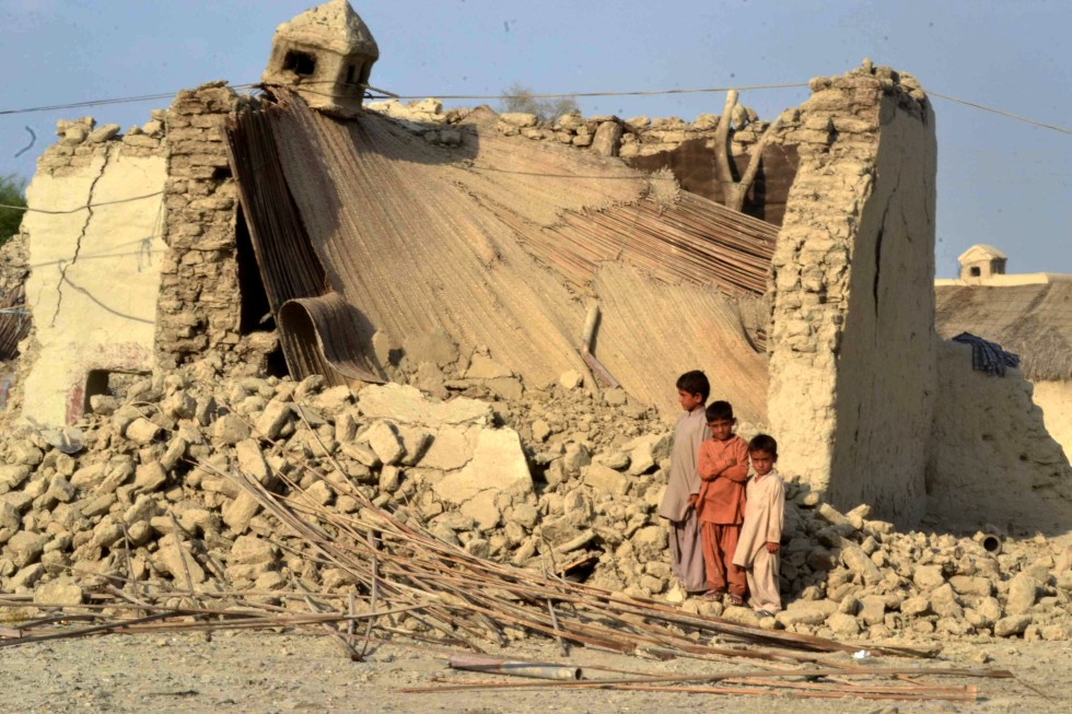
    September 28, 2013 – PAKISTAN - Several cities of Pakistan’s Sindh and Balochistan provinces were on Saturday hit by a massive aftershock measuring 6.8, three days after a 7.7 magnitude earthquake struck the region killed over 500 people. Pakistan’s Met office measured the earthquake at 7.2, while the US Geological Survey (USGS) recorded it at 6.8 on the Richter Scale. Tremors were felt in provincial capitals Karachi and Quetta. All the local television channels showed people rushing out of their offices in Karachi after the latest tremors. “The tremors were not so strong as last time but one could still feel the chairs moving and tables shaking,” Adnan Ahmed a employee of a media group said. Zahid Rafi, director of the National Seismic Centre, said that the origin of this earthquake was once again Awaran. “But these were more like strong aftershocks and more can be expected,” he said. He said the tremors could be felt in major cities like Karachi, Quetta, Larkana, Jacobabad, Khairpur, Naseerabad, Sukkur, Mustung and Kharan. Rescue teams are still to reach several remote areas, including the worst-hit Balochistan’s Awaran district near the epicentre of Tuesday’s temblor. While the official death count stands at 515, unofficial figures are as high as 700, with more than 800 injured. The earthquake left more than 50,000 people homeless in these areas.

    The quake-hit area was also rocked on Friday by a massive aftershock measuring 5 on the Richter scale. Pakistan’s met office said the epicenter of the aftershock was in Ormara and its depth was around 10 km. According to an official preliminary damage assessment, Awaran has borne just “partial damage” of 30 to 40 percent. Two other districts? Mashkal and Malar ? were said to be “badly hit” with 80 to 90 per cent damage. A map showing the damages was uploaded by ISPR chief Maj Gen Asim Bajwa last night via Twitter to “just to give an idea about the extent of damage.” Meanwhile, an army helicopter carrying relief goods to the quake-hit areas was fired at in Mashkay area of Awaran district by suspected militants on Friday. The helicopter was not damaged in the attack. This was the second attack on an army helicopter in the area. Yesterday, two army generals, including the head of the National Disaster Management Authority, had a narrow escape when rockets were fired at their helicopter. Security personnel accompanying a team of doctors for relief operations were fired at on Wednesday. Though the army and Frontier Corps have moved 1,000 troops in the worst-hit areas, it is feared that people may still be trapped under the debris of thousands of collapsed mud homes. The area near the epicentre is a stronghold of Baloch nationalist militants. –Times of India


    _________________
    What is life?
    It is the flash of a firefly in the night, the breath of a buffalo in the wintertime. It is the little shadow which runs across the grass and loses itself in the sunset.

    With deepest respect ~ Aloha & Mahalo, Carol
    Carol
    Carol
    Admin
    Admin


    Posts : 31775
    Join date : 2010-04-07
    Location : Hawaii

    The Earthquake/Seismic Activity Log - Page 3 Empty Re: The Earthquake/Seismic Activity Log

    Post  Carol Mon Sep 30, 2013 8:44 am

    The Earthquake/Seismic Activity Log - Page 3 Pakistan_1
    Pakistan’s second large earthquake not an aftershock: 22 dead

    September 30, 2013 – PAKISTAN - A powerful 6.8-magnitude earthquake hit southwest Pakistan on Saturday, killing at least 22 people in a region already devastated by a tremor which left more than 300 people dead this week, local officials said. Earthquake survivors face long wait for aid. “The death toll is increasing. Rescue workers have so far recovered 22 dead bodies,” Hari Fal, the top government official in Khuzdar town told Agence-France Presse (AFP), adding that more than 50 people have been wounded. Officials fear the toll in Saturday’s quake in Awaran, the poorest district in the southwest province of Baluchistan, could still rise further. The new quake struck the remote district of Awaran, at a depth of 14 kilometers at 12:34 pm (0734 GMT) according to the US Geological Survey. Although USGS said it was an aftershock of the Tuesday 7.7-magnitude quake, an official at the National Seismic Centre of Pakistan classified it as a new earthquake. “It was not an aftershock, it was an independent earthquake,” Zahid Rafi, the centre’s director, told Geo TV. Awaran was shattered by a 7.7-magnitude quake on Tuesday, September 24, which left 359 dead and more than 100,000 people homeless. Relief efforts there have been thwarted by insurgent attacks on rescue convoys, with local officials admitting that teams have been unable to reach thousands of survivors in the worst-hit areas. “This new earthquake destroyed all that remains of the first quake, two villages destroyed completely,” said Abdul Malik, provincial chief minister of Baluchistan. Pakistan’s chief meteorologist Arif Mehmood told Express News that the magnitude of Saturday’s quake measured 7.2.

    Officials said villagers were digging through newly created debris and that dozens of wounded people have been taken to a make-shift hospital in Mashkey area, Awaran. “The condition of some the injured was critical,” Doctor Asif Anwar told AFP from the makeshift hospital. Deputy Commissioner of Awaran, Abdul Rasheed Baloch told Geo TV that quake destroyed hundreds of mud houses in the Mashkey area, saying that “a lot of people have been trapped under the rubble. The telephone system has been damaged and we are not able to talk to someone and find out the exact information about the losses… But we have reports of severe losses in that area,” Baloch said. An AFP reporter in Awaran said Saturday that hundreds of patients being treated in the aftermath of the previous quake fled a hospital in panic as the new tremor hit. Even before the latest quake struck, local officials said some 30,000 survivors were still waiting for aid. As well as being remote, the area is a stronghold of Baluch separatist rebels waging a decade-long insurgency against the Pakistani state. Since the Tuesday quake, insurgents have launched several attacks on rescue teams and issued threats. On Thursday, a helicopter carrying the head of the NDMA came under rocket fire by insurgents while flying in Awaran district. No-one was hurt and no damage was done. On Friday, insurgents also opened fire on another helicopter and, in two separate incidents, fired on rescue convoys, officials said, adding that no one was hurt in the attacks. The situation has forced officials to abandon efforts to reach survivors directly, saying instead they will work through village committees and private NGOs. Manan Baloch, a leader of the Baluchistan National Movement, allied to the Baluchistan Liberation Front, told AFP that his group will only allow private NGOs and local officials to help survivors. “We will not allow army or FC (paramilitary Frontier Corps) here, only NGOs or local officials are allowed to come here,” he said. –Rappler


    _________________
    What is life?
    It is the flash of a firefly in the night, the breath of a buffalo in the wintertime. It is the little shadow which runs across the grass and loses itself in the sunset.

    With deepest respect ~ Aloha & Mahalo, Carol
    Carol
    Carol
    Admin
    Admin


    Posts : 31775
    Join date : 2010-04-07
    Location : Hawaii

    The Earthquake/Seismic Activity Log - Page 3 Empty Re: The Earthquake/Seismic Activity Log

    Post  Carol Mon Sep 30, 2013 8:46 am

    The Earthquake/Seismic Activity Log - Page 3 606x454_2609-pakistan-new-island-earthquake-ii
    Pakistan gets three new islands following earthquake
    September 27, 2013 – PAKISTAN – Pakistan has just got three brand new islands — thanks to a major earthquake. When the shock of the temblor subsided on Tuesday, people living in the coastal town of Gwadar were stunned to see a new island in the sea. That’s not all. Two other islands have come up along the Balochistan coast. “The island near Gwadar is about 600 feet in diameter and has a height of about 30 feet,” Muhammad Moazzam Khan, technical advisor at WWF Pakistan, told IANS over telephone. He said “gas was coming out” of the island, which primarily consists of “stones and soft mud.” The two islands near Ormara town are small. Khan said the islands had a diameter of about “30-40 feet and a height of about 2-3 feet. Gas is also coming out,” he said. He said that while some islands which form suddenly “stay on,” others gradually fade away. He explained that the islands were formed following the massive earthquake that rocked Balochistan province Tuesday. The death toll in the 7.7-magnitude earthquake has reached 348, and a total of 20,000 houses were destroyed. This is not the first time islands have formed off the Pakistan coast. “In 1945, two big islands had formed near the coast. One was two kilometers long while the other was half kilometer long,” said Khan. –Times of India

    Methane dangers: A match was put to the fissures from where methane was rising. “We put the fire out in the end, but it was quite a hassle. Not even the water could kill it, unless one poured buckets over it,” the resident said. Muhammad Danish, a marine biologist from Pakistans National Institute of Oceanography, told PressTV a team of experts landed on the island yesterday and found methane gas. “Our team found bubbles rising from the surface of the island which caught fire when a match was lit and we forbade our team to start any flame. It is methane gas,” Danish said. Exactly how much methane is accumulated within the mud is unknown, he said, but the risk of explosion is very real. –News


    _________________
    What is life?
    It is the flash of a firefly in the night, the breath of a buffalo in the wintertime. It is the little shadow which runs across the grass and loses itself in the sunset.

    With deepest respect ~ Aloha & Mahalo, Carol
    Carol
    Carol
    Admin
    Admin


    Posts : 31775
    Join date : 2010-04-07
    Location : Hawaii

    The Earthquake/Seismic Activity Log - Page 3 Empty Re: The Earthquake/Seismic Activity Log

    Post  Carol Tue Oct 08, 2013 9:16 pm

    The Earthquake/Seismic Activity Log - Page 3 Ann_mexico_quake_120320_wg
    Series of 6 earthquakes ripple through Mexico
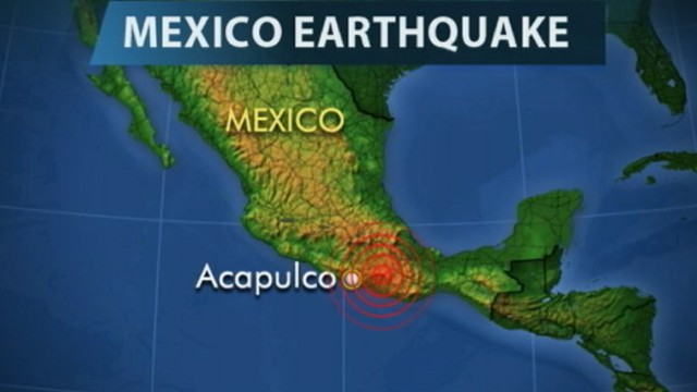
    October 8, 2013 – MEXICO – A series of at least six earthquakes — two reaching at least 5.0- magnitude — struck Sunday in the Mexican state of Guerrero, which is still reeling from deadly tropical storms last month. The epicenter of the strongest quake — 5.21-magnitude, at 9.27 local time (1527 GMT), according to the National Seismological Service — was located in the mountainous area where a September 16 mudslide buried a whole town. “We are monitoring the areas affected by the recent rains because the soil is moist and that can generate problems” from the trembling, said Jose Luis Serna, civil protection director of the town nearest the epicenter, Coyuca de Benitez. “But so far, we have no news,” he said. The quakes were also felt with moderate intensity in the resort town of Acapulco, which is recovering from the massive flooding brought on when storms Ingrid and Manuel swept across the country in mid-September. Authorities recommended moving “away from risk areas, such as slopes and where there are cracks in the ground,” Guerrero governor Angel Aguirre said in his Twitter account. Tourists in Acapulco were evacuated from hotels to the Costera Miguel Aleman, the port town’s main tourist road. All six quakes were recorded between 9am local time (1500 GMT) and 10.36am (1636 GMT), and so far no damage has been reported in Guerrero state. — AFP


    _________________
    What is life?
    It is the flash of a firefly in the night, the breath of a buffalo in the wintertime. It is the little shadow which runs across the grass and loses itself in the sunset.

    With deepest respect ~ Aloha & Mahalo, Carol
    Carol
    Carol
    Admin
    Admin


    Posts : 31775
    Join date : 2010-04-07
    Location : Hawaii

    The Earthquake/Seismic Activity Log - Page 3 Empty Re: The Earthquake/Seismic Activity Log

    Post  Carol Tue Oct 08, 2013 9:18 pm

    The Earthquake/Seismic Activity Log - Page 3 California+Earthquake+Early+Warning+Demonstration+O5C_G_o0CI3l
    U.S. seismologist calls for national early warning system for earthquakes
    October 5, 2013 – CALIFORNIA – An eminent U.S. seismologist is urging the installation of a national early warning system to alert people to an impending earthquake. Richard Allen, director of the University of California, Berkeley’s Seismology Laboratory and professor of Earth and planetary sciences, writing a Comment piece in the journal Nature, has taken politicians and public officials to task for not putting an early warning system in place before the next major quake occurs. Recent decades have seen dramatic improvement in the technology to detect quakes, he said, largely led by Japan, as proven by the advance warning people there received about the deadly earthquake that struck in 2011. With the advance notice trains were stopped, chemical plants shut down and people were able to take cover, Allen said. While California, Oregon and Washington have initiated programs to create early warning systems for parts of their areas, that’s not enough, Allen wrote; there should be an expansion of such systems to cover the entire United States, particularly areas most at risk. It’s not a matter of whether a major quake will strike, it’s when, Allen said, and if people have prior warning — the amount of which would depend on how far they are from the epicenter — then lives could be saved and property damage minimized. –Space Daily


    _________________
    What is life?
    It is the flash of a firefly in the night, the breath of a buffalo in the wintertime. It is the little shadow which runs across the grass and loses itself in the sunset.

    With deepest respect ~ Aloha & Mahalo, Carol
    Carol
    Carol
    Admin
    Admin


    Posts : 31775
    Join date : 2010-04-07
    Location : Hawaii

    The Earthquake/Seismic Activity Log - Page 3 Empty Re: The Earthquake/Seismic Activity Log

    Post  Carol Fri Oct 11, 2013 11:40 am

    The Earthquake/Seismic Activity Log - Page 3 Tengboche__himalayas___nepal_by_mselam
    800,000 could die from magnitude 8 earthquake in Himalayas
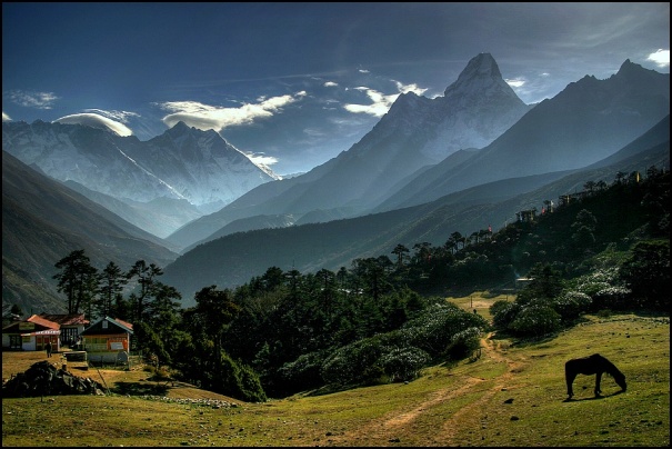
    October 10, 2013 – INDIA - Over 800,000 people may die if an earthquake measuring eight on the Richter scale occurs in the seismically active Himalayan states from Jammu and Kashmir to Arunachal Pradesh, National Disaster Management Authority’s Vice Chairman M. Shashidhar Reddy has warned. The entire Himalayan belt is seismically very active and during a short span of 53 years between 1897 and 1950, four major earthquakes, (Shillong in 1897, Kangra in 1905, Bihar-Nepal in 1934 and Assam in 1950) exceeding magnitude eight on the Richter scale occurred in the region causing vast devastation. “No such earthquake has occurred since 1950. Studies indicate that enough strains have accumulated to generate magnitude 8 or larger earthquakes in the Himalayan region. If an earthquake of magnitude eight occurs in the Himalayan states, eight to nine lakh people may lose their lives,” the NDMA vice chief told PTI. When and where such an earthquake would occur is not known and therefore, the best approach to face such an eventuality was to work for developing an earthquake-resilient society, Reddy said. –India West - http://www.indiawest.com/news/14145-800-000-could-die-from-magnitude-8-quake-in-himalayas.html


    _________________
    What is life?
    It is the flash of a firefly in the night, the breath of a buffalo in the wintertime. It is the little shadow which runs across the grass and loses itself in the sunset.

    With deepest respect ~ Aloha & Mahalo, Carol
    Carol
    Carol
    Admin
    Admin


    Posts : 31775
    Join date : 2010-04-07
    Location : Hawaii

    The Earthquake/Seismic Activity Log - Page 3 Empty Re: The Earthquake/Seismic Activity Log

    Post  Carol Fri Oct 11, 2013 11:42 am

    The Earthquake/Seismic Activity Log - Page 3 Ann_mexico_quake_120320_wg
    Series of 6 earthquakes ripple through Mexico
    October 8, 2013 – MEXICO – A series of at least six earthquakes — two reaching at least 5.0- magnitude — struck Sunday in the Mexican state of Guerrero, which is still reeling from deadly tropical storms last month. The epicenter of the strongest quake — 5.21-magnitude, at 9.27 local time (1527 GMT), according to the National Seismological Service — was located in the mountainous area where a September 16 mudslide buried a whole town. “We are monitoring the areas affected by the recent rains because the soil is moist and that can generate problems” from the trembling, said Jose Luis Serna, civil protection director of the town nearest the epicenter, Coyuca de Benitez. “But so far, we have no news,” he said. The quakes were also felt with moderate intensity in the resort town of Acapulco, which is recovering from the massive flooding brought on when storms Ingrid and Manuel swept across the country in mid-September. Authorities recommended moving “away from risk areas, such as slopes and where there are cracks in the ground,” Guerrero governor Angel Aguirre said in his Twitter account. Tourists in Acapulco were evacuated from hotels to the Costera Miguel Aleman, the port town’s main tourist road. All six quakes were recorded between 9am local time (1500 GMT) and 10.36am (1636 GMT), and so far no damage has been reported in Guerrero state. — AFP


    _________________
    What is life?
    It is the flash of a firefly in the night, the breath of a buffalo in the wintertime. It is the little shadow which runs across the grass and loses itself in the sunset.

    With deepest respect ~ Aloha & Mahalo, Carol
    Carol
    Carol
    Admin
    Admin


    Posts : 31775
    Join date : 2010-04-07
    Location : Hawaii

    The Earthquake/Seismic Activity Log - Page 3 Empty Re: The Earthquake/Seismic Activity Log

    Post  Carol Mon Oct 14, 2013 11:18 am

    The Earthquake/Seismic Activity Log - Page 3 Greece-10-12
    6.4 magnitude earthquake strikes seafloor south of Greece
    October 12, 2013 – GREECE - An earthquake of 6.4 magnitude was detected in the Mediterranean Sea west of the island of Crete on Saturday, but there were no reports of casualties or damage, the Greek police and fire brigade said. The center of the quake, which struck at 1311 GMT, was 22.5 miles below the seabed 43 miles west of Chania on Crete, the U.S. Geological Survey said. Greece is often rocked by earthquakes. Most cause no serious damage but a 5.9 magnitude quake in 1999 killed 143 people. -Reuters


    The Earthquake/Seismic Activity Log - Page 3 Ven-10-12
    6.1 magnitude earthquake strikes off the coast of Venezuela
    October 12, 2013 - VENEZUELA – Parts of Guyana shook last night in the aftermath of a 6.0-Richter scale earthquake just offshore Sucre, Venezuela and about 87 kilometers west of Port of Spain, in neighboring Trinidad and Tobago. At around 10:15 pm, the effects of the earthquake could be felt here and persons from across the country reported feeling the tremors. The tremors would have been the strongest in the northwest of the country. There were no reports of injuries or damage at press time. “We are on the South American plate … when its tip rubs the tip of the Caribbean plate it will create waves and we will have these (tremors) but the thing is no one knows when this will happen…,” science professor and astronomer Dr. Alfred Bhulai explained last evening. Moderate shaking was experienced in many parts of Trinidad and the duration of the temblor closer to the epicenter was between 15 and 20 seconds. The US Geological Survey is reporting that the earthquake occurred at a depth of 79.4 km.  –Stabroek News


    _________________
    What is life?
    It is the flash of a firefly in the night, the breath of a buffalo in the wintertime. It is the little shadow which runs across the grass and loses itself in the sunset.

    With deepest respect ~ Aloha & Mahalo, Carol
    Carol
    Carol
    Admin
    Admin


    Posts : 31775
    Join date : 2010-04-07
    Location : Hawaii

    The Earthquake/Seismic Activity Log - Page 3 Empty Re: The Earthquake/Seismic Activity Log

    Post  Carol Mon Oct 14, 2013 9:32 pm

    7.2 Quake Hits Central Philippines, Killing 6
    A 7.2-magnitude earthquake struck in the central Philippines on Tuesday morning, collapsing roofs and buildings, cracking walls and roads and killing at least six people.

    The quake was centered 56 kilometers (35 miles) deep below Carmen town on Bohol Island and was felt across the region.

    Radio station DZMM quoted civil defense officials as saying that four people died when part of a fish port collapsed in nearby Cebu city, across the strait from Bohol.

    Two more people died and 19 were injured when the roof of a market in Mandaue in Cebu province collapsed, according to TV reports. People rushed out of buildings and homes, including hospitals as aftershocks continued.

    Photos from Cebu broadcast on TV stations showed a fallen concrete 2-story building, and reports said two people were pulled alive, including an 8-month-old baby.

    Bohol Gov. Edgardo Chatto said that a church was reported damaged in the provincial capital of Tagbilaran and a part of the city hall collapsed, injuring one person.

    A 17th-century stone church in Loboc town, southwest of Carmen, crumbled to pieces, with nearly half of it reduced to rubble. Other old churches dating from the Spanish colonial period, which are common in the central region, also reported damage.

    Tuesday is a national holiday and that may have reduced casualties because schools and offices are closed.

    Earthquakes are common in the Philippines, which lies along the Pacific "Ring of Fire."

    Cebu province, about 570 kilometers (350 miles) south of Manila, has a population of more than 2.6 million people. Nearby Bohol has 1.2 million people and is popular among foreigners because of its beach and island resorts.


    _________________
    What is life?
    It is the flash of a firefly in the night, the breath of a buffalo in the wintertime. It is the little shadow which runs across the grass and loses itself in the sunset.

    With deepest respect ~ Aloha & Mahalo, Carol
    magamud
    magamud


    Posts : 1280
    Join date : 2012-06-17

    The Earthquake/Seismic Activity Log - Page 3 Empty Re: The Earthquake/Seismic Activity Log

    Post  magamud Tue Oct 15, 2013 2:20 pm

    How can anyone live near the West coast of amerika? All the cities are wastelands and the human spirit is in a chuthulu dream world. Sad...
    Jenetta
    Jenetta


    Posts : 1978
    Join date : 2010-04-16
    Location : British Columbia Canada

    The Earthquake/Seismic Activity Log - Page 3 Empty Re: The Earthquake/Seismic Activity Log

    Post  Jenetta Wed Oct 16, 2013 1:44 am

    magamud wrote:How can anyone live near the West coast of amerika?  All the cities are wastelands and the human spirit is in a chuthulu dream world.  Sad...

    Actually Magamud, Vancouver British Columbia is one of the most beautiful cities in the world (without chemtrails littering the skies) and the island I live on along with all the other islands in my vicinity have been described as "paradise lost" which doesn't imply that they are wastelands. People (individuals) are unique wherever you live as is their spirit in most cases. What does "chuthulu" mean?

    Bob Marley - Don't worry be Happy

    https://www.youtube.com/watch?v=L3HQMbQAWRc


    _________________________________________
    As it is above; so it is below
    magamud
    magamud


    Posts : 1280
    Join date : 2012-06-17

    The Earthquake/Seismic Activity Log - Page 3 Empty Re: The Earthquake/Seismic Activity Log

    Post  magamud Wed Oct 16, 2013 7:24 am

    I am glad you are projecting happiness with my information Jenetta.  My paradise lost is Gods Kingdom manifested with righteousness to enforce the law.  The blindness to this is the wasteland.  This is insight into what is Lucifers light.  

    Cthulhu is a reference to Lucifer from HP lovecrafts journeys.  He realized that we are in the Devils dream of what reality is.  He uses his light to create a matrix to fool gods children that he is god.  The world then forms around this except for a very narrow path or ray of light that God holds true to show Lucifer that he is righteous.  This is what the Bible, Prophets and God Son is for.   To hold this line to be true in Lucifers light throughout time.  This is the meaning of the narrow path, the Orobourus, the harvest, the beginning and the ending.

    Be well...
    Carol
    Carol
    Admin
    Admin


    Posts : 31775
    Join date : 2010-04-07
    Location : Hawaii

    The Earthquake/Seismic Activity Log - Page 3 Empty Re: The Earthquake/Seismic Activity Log

    Post  Carol Thu Oct 17, 2013 12:43 pm

    Millions to take part in global earthquake drill
    http://apnews.myway.com/article/20131017/DA9FMIC02.html
    Oct 17, 12:36 AM (ET) - LOS ANGELES (AP) - Hoping to survive an earthquake, many Californians and people in earthquake prone regions around the world were gearing up for a major earthquake drill. More than 24 million people, including 9 1/2 million in California, have signed up to duck under their desks at 10:17 a.m. local time Thursday, cover their heads and hold on to something sturdy. The exercise allows first responders to dust off their emergency response plans and transportation departments to practice slowing down trains in the event of real shaking. The Great ShakeOut was first held in California in 2008 and participation has since spread around the globe. This year, Japan, Canada, Italy and Guam planned to join the U.S. in the drill. "Everyone everywhere should know how to protect themselves during an earthquake," lead organizer Mark Benthien said. Participation has exceeded last year's level despite a government shutdown that prevented the Federal Emergency Management Agency from doing last-minute promotion of the drill on social media sites, Benthien said. Southern California has not experienced a devastating quake since the 1994 Northridge disaster that killed 60 people and injured more than 7,000. In recent weeks, parts of the world have been rattled by powerful quakes, including a magnitude-7.1 jolt that killed more than 100 people in the Philippines and damaged historic churches. Drill organizers said this year's focus is on fires that may be sparked by ruptured utility lines after a quake.
    read more at link


    _________________
    What is life?
    It is the flash of a firefly in the night, the breath of a buffalo in the wintertime. It is the little shadow which runs across the grass and loses itself in the sunset.

    With deepest respect ~ Aloha & Mahalo, Carol
    Carol
    Carol
    Admin
    Admin


    Posts : 31775
    Join date : 2010-04-07
    Location : Hawaii

    The Earthquake/Seismic Activity Log - Page 3 Empty Re: The Earthquake/Seismic Activity Log

    Post  Carol Sat Oct 19, 2013 4:54 pm

    The Earthquake/Seismic Activity Log - Page 3 Screen_shot_2013-10-19_at_10.18.02_pm.si
    6.5 magnitude earthquake strikes off Mexico coast
    A 6.5 magnitude earthquake struck off the western coast of Mexico in the Gulf of California between the Mexican states of Sonora and Baja California Sur, the US Geological Survey reported.

    The epicenter of the quake was 10 kilometers deep in the Sea of Cortez. Emergency services in Mexican Sonora and Sinaloa states said there were no immediate reports of casualties and it was not yet clear how the quake had affected Baja California Sur.

    The quake was initially reported to have reached a magnitude of 6.8, but was later downgraded to 6.5 by USGS.

    A tsunami warning has not been issued.

    Over 138,300 people live within 100 kilometers from the epicenter of the earthquake, according to the Global Disaster Alert and Coordination System (GDACS).

    "We felt the quake pretty strongly, but we don't have any reports of damage," said Ana Carranza, a hotel worker in Loreto on the Baja California Peninsula.

    Mexico is located atop three large tectonic plates and is one of the world's most seismically active regions.

    On August 21, two strong 6.0 magnitude quakes hit central and southern Mexico, causing extensive damage. One of the earthquakes affected the capital of Mexico City and the resort city of Acapulco, prompting the evacuation of hundreds of people. Numerous injuries were reported.

    The country’s deadliest natural disaster occurred in September 1985 when an 8.1 magnitude earthquake killed more than 9,500 people in Mexico City.


    _________________
    What is life?
    It is the flash of a firefly in the night, the breath of a buffalo in the wintertime. It is the little shadow which runs across the grass and loses itself in the sunset.

    With deepest respect ~ Aloha & Mahalo, Carol
    Carol
    Carol
    Admin
    Admin


    Posts : 31775
    Join date : 2010-04-07
    Location : Hawaii

    The Earthquake/Seismic Activity Log - Page 3 Empty Re: The Earthquake/Seismic Activity Log

    Post  Carol Sun Oct 20, 2013 10:58 am

    The Earthquake/Seismic Activity Log - Page 3 Png-oct-16
    7.1 magnitude earthquake strikes region of Papua New Guinea
    October 16, 2013 – PAPUA, NG - An earthquake with a magnitude of 7.1 struck off the coast of Papua New Guinea on Wednesday, the United States Geological Survey reported. The USGS said the quake’s epicenter was 47 miles west-southwest of the island state’s capital Bougainville and (58 km) 36.2 miles deep. The quake was preceded by several 5.0+ magnitude foreshocks. This is the fourth 7.0+ magnitude earthquake to strike the planet in less than a month. There have been no initial reports cited of damage or injuries. -TEP


    _________________
    What is life?
    It is the flash of a firefly in the night, the breath of a buffalo in the wintertime. It is the little shadow which runs across the grass and loses itself in the sunset.

    With deepest respect ~ Aloha & Mahalo, Carol
    mudra
    mudra


    Posts : 23223
    Join date : 2010-04-09
    Age : 69
    Location : belgium

    The Earthquake/Seismic Activity Log - Page 3 Empty Re: The Earthquake/Seismic Activity Log

    Post  mudra Fri Oct 25, 2013 2:57 pm

    EMSC earthquake notification

    Magnitude 7.3 25/10/2013 17:10 OFF EAST COAST OF HONSHU, JAPAN

    These parameters are preliminary and subject to revisions.
    For updates, please consult: http://www.emsc-csem.org


    A magnitude 7.3 earthquake has occurred OFF EAST COAST OF HONSHU, JAPAN at:
    37.20N 144.65E Depth 5km 25/10/2013 at 17:10:16 (Universal Time)

    Earthquake location with respect to nearby cities:
    351 km E Sendai (pop 1037562, local time 02:10:16.5 2013-10-26)
    325 km SE Ishinomaki (pop 117233, local time 02:10:16.5 2013-10-26)
    324 km SE Kesennuma (pop 59116, local time 02:10:16.5 2013-10-26)

    Love Always
    mudra
    Carol
    Carol
    Admin
    Admin


    Posts : 31775
    Join date : 2010-04-07
    Location : Hawaii

    The Earthquake/Seismic Activity Log - Page 3 Empty Re: The Earthquake/Seismic Activity Log

    Post  Carol Thu Oct 31, 2013 10:02 am

    A series of serpent-like sea creatures have recently been found washed up on California beaches, leading some scientists to speculate that an ancient myth about the fish portending earthquakes could be true.
    In recent weeks several oarfish, rarely seen giants of the deep that can grow up to 50-feet long, have been found along the southern California coast.
    A centuries-old Japanese myth holds that oarfish beach themselves prior to an earthquake. One 2010 report found that some Japanese feared an earthquake in that country following oarfish sightings prior to destructive tremors in Chile and Haiti.
    The fish, believed to be the ocean’s largest scaled fish, also washed up in the months before the 2011 earthquake and tsunami near Sendai, Japan.
    Some scientists have speculated that the ancient myth could be rooted in reality, speculating that the deep-dwelling fish might be attuned to seismic changes.
    But most marine biologists believe there still is not enough evidence to conclude that oarfish are harbingers of earthquakes. The beachings, they say, may be coincidental.
    “I don’t discredit or disrespect the Japanese theory at all,” Pat Abbott, a seismologist at San Diego State University told reporters. “The science and study just isn’t there. There’s a big difference between suggesting something like that and proving it. What did an animal sense that maybe we didn’t that told them about a coming event?”


    _________________
    What is life?
    It is the flash of a firefly in the night, the breath of a buffalo in the wintertime. It is the little shadow which runs across the grass and loses itself in the sunset.

    With deepest respect ~ Aloha & Mahalo, Carol
    Carol
    Carol
    Admin
    Admin


    Posts : 31775
    Join date : 2010-04-07
    Location : Hawaii

    The Earthquake/Seismic Activity Log - Page 3 Empty Re: The Earthquake/Seismic Activity Log

    Post  Carol Sun Nov 17, 2013 9:53 pm

    The Earthquake/Seismic Activity Log - Page 3 Scotia-sea

    6.8 magnitude earthquake rattles ocean floor of Scotia Sea
    Powerful 7.8 magnitude earthquake strikes Scotia Sea
    November 16, 2013 – SOUTH AMERICA - A strong 6.8 magnitude undersea earthquake struck in a remote area known as Scotia Sea, between the furthest tip of South America and Antarctica, U.S. monitors said late Friday. There is a low likelihood that the quake, which struck at 0334 GMT Saturday, will cause casualties or damage because of its remote location, said the U.S. Geological Survey, which monitors earthquakes worldwide. –The News

    November 17, 2013 – SOUTH AMERICA – A powerful 7.8 magnitude undersea earthquake struck in the Scotia Sea, a remote region in the far south Atlantic near Antarctica, US earthquake monitors reported Sunday. The quake struck at 0904 GMT in the ocean some 893 kilometers (550 miles) southwest of Grytviken, South Georgia, and 1,140 kilometers (710 miles) southeast of Ushuaia, Argentina, said the US Geological Survey, which monitors earthquakes worldwide. This is the second major earthquake to strike the region in 24 hours. Today’s earthquake was preceded by a 6.8 magnitude earthquake. –The News, TEP


    The Earthquake/Seismic Activity Log - Page 3 14
    5.5 magnitude earthquake shakes Tokyo, halts trains: nerves frayed
    as Fukushima decomissioning reaches critical stage
    November 16, 2013 – TOKYO, JAPAN - A 5.5 magnitude earthquake hit eastern Japan on Saturday. Tremors were felt from inside Tokyo skyscrapers, and the city’s high-speed train service was halted as a precaution. The earthquake struck at 8:44 p.m. local time (11:44 a.m. GMT) at a depth of 63 kilometers (39 miles) in the Chiba prefecture which neighbors Tokyo, the US Geological Survey reported.  The quake shook skyscrapers in the Japanese capital and temporarily halted the city’s high-speed train service, according to AFP. The trains soon resumed after a track inspection. Local broadcaster NHK assured that neither Tokyo’s Narita International Airport nor regional nuclear installations were affected by the earthquake. There were no reports of damage or casualties. It comes just one week after another 5.5 earthquake struck close to the capital, and three weeks after a major 7.3 magnitude quake sent small tsunamis to Japan’s northeast coast and prompted an evacuation at the crippled Fukushima Daiichi nuclear plant.

    While earthquakes of different magnitudes are not uncommon in Japan, the March 2011 earthquake and tsunami disaster that triggered the core meltdowns of three reactors at the Fukushima plant has made every quake report in the region particularly alarming. As the world watches with apprehension at how Fukushima’s decommissioning work unfolds, prominent Japanese-Canadian scientist David Suzuki warned last week that another nearby earthquake of magnitude 7 or higher could trigger a serious nuclear catastrophe, decimating Japan and reaching the U.S. west coast. “If the fourth [reactor] goes under an earthquake and those rods are exposed, then it’s bye, bye, Japan and everybody on the west coast of North America should be evacuated. And if that isn’t terrifying, I don’t know what is,” Suzuki said. –RT News


    _________________
    What is life?
    It is the flash of a firefly in the night, the breath of a buffalo in the wintertime. It is the little shadow which runs across the grass and loses itself in the sunset.

    With deepest respect ~ Aloha & Mahalo, Carol
    Carol
    Carol
    Admin
    Admin


    Posts : 31775
    Join date : 2010-04-07
    Location : Hawaii

    The Earthquake/Seismic Activity Log - Page 3 Empty Re: The Earthquake/Seismic Activity Log

    Post  Carol Sun Dec 29, 2013 12:00 pm

    The Earthquake/Seismic Activity Log - Page 3 Usgs-seismichazardmapusa3
    Seismic shake-up: string of earthquakes rumble across U.S.
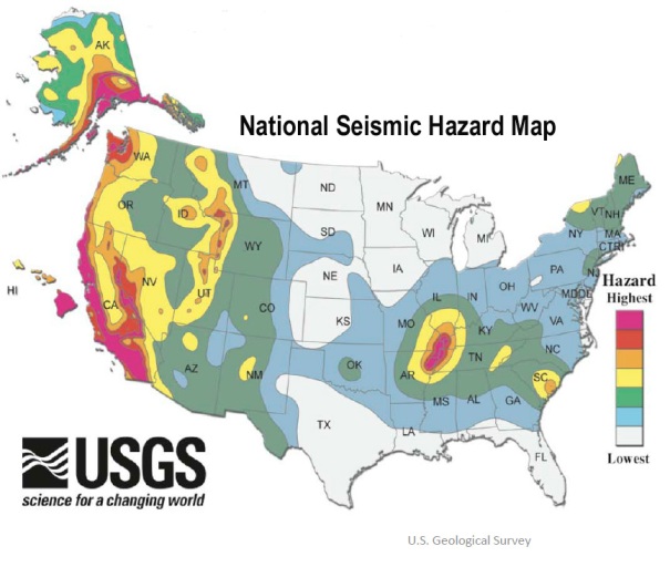
    December 23, 2013 – KANSAS - The Kansas Geological Society is investigating whether a recent earthquake in southern Kansas might have been caused by oil production practices in the area. But KGS interim director Rex Buchanan said it might be difficult to determine if the 3.8 earthquake on Dec. 16 near Caldwell was man-made or caused by natural forces. No evidence has been found yet to suggest hydraulic fracturing caused the quake, said Buchanan. It’s more common for minor quakes near oil production sites to be caused by the disposal of salt water waste, The Lawrence Journal-World reported. “There’s a lot of saltwater produced with oil,” he said. “Once you separate that off, you need to dispose of it. In Kansas, that’s done in wells deep in the subsurface. There is production and disposal wells in the general vicinity around there.” The Kansas Corporation Commission, which regulates oil and gas production in the state, is also investigating the issue. “It is important to point out that Kansas has a long history of oil production with very few reported incidents of any kind,” KCC spokesman Jesse Borjon said in an email to the newspaper. “The KCC is looking into the issue of seismic activity as it relates to oil and gas activities. We have been in communication with the Kansas Geological (Survey) and continue to gather information.” It’s possible the earthquake was entirely natural, Buchanan said. -LJW

    2.3 magnitude earthquake in Ky: Kentucky Emergency Management is reporting that a 2.3 magnitude earthquake was felt near Owingsville around 5:58am Monday. The USGS reports that the disturbance was centered near the Sharpsburg area. Many viewers report feeling the tremors throughout parts of Central Kentucky. Officials report that this type of event is relatively minor. – WKYT

    3.3 magnitude earthquake strikes Oklahoma: MCCORD – An earthquake was reported Sunday morning, the U.S. Geological Survey reported. The 3.3 magnitude earthquake shook at about 10:25 a.m. Its epicenter was reportedly 15 miles south of McCord, 17 miles south of Ponca City and 71 miles north of Oklahoma City, the U.S. Geological Survey reported. No damage was immediately reported. –News OK

    3.3 magnitude earthquake rattles Texas: Perhaps we should write a story when there’s not an earthquake near Azle. For the 14th and 15th time in the last 30 days, people who live northwest of Fort Worth have felt the earth rumble. The latest incident, a 3.3-magnitude quake, was recorded by the U.S. Geological Survey at 7:11 a.m. Monday four miles northwest of Azle just off of S. Reno Rd. There was also an earthquake at 11:31 a.m. Sunday. It also registered as a 3.3-magnitude, according to the USGS. It was centered two miles northwest of Azle, just north of Willow Wood Drive. “Shook my bed and made the walls creak,” wrote Azle resident Kim Johnson, who was upstairs in a two-story home. “We now have a few cracks in our vaulted ceilings upstairs. When will it end?” Writing on the WFAA Facebook page, Sandra Tingle said she’s worried about liability. “My insurance company told me unless a fault line is determined to be under your property, it’s not covered,” she said. Sunday’s tremor is the fourth-strongest in the past month. The most powerful registered 3.7-magnitude and struck 30 miles west of Azle on December 9. -KHOU

    4.7 magnitude earthquake strikes SE California: A shallow magnitude 4.7 earthquake was reported Monday morning 31 miles from Lone Pine, Calif., according to the U.S. Geological Survey. The temblor occurred at 5:39 a.m. PST near the surface. According to the USGS, the epicenter was 41 miles from Ridgecrest, 53 miles from Porterville and 57 miles from Lindsay. In the past 10 days, there have been no earthquakes magnitude 3.0 or greater centered nearby. –LA Times


    _________________
    What is life?
    It is the flash of a firefly in the night, the breath of a buffalo in the wintertime. It is the little shadow which runs across the grass and loses itself in the sunset.

    With deepest respect ~ Aloha & Mahalo, Carol
    Carol
    Carol
    Admin
    Admin


    Posts : 31775
    Join date : 2010-04-07
    Location : Hawaii

    The Earthquake/Seismic Activity Log - Page 3 Empty Re: The Earthquake/Seismic Activity Log

    Post  Carol Sun Dec 29, 2013 12:02 pm

    The Earthquake/Seismic Activity Log - Page 3 111017.El.%20Hierro.volcano
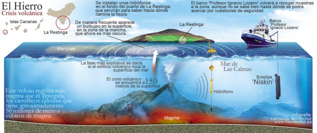
    Magma rising: rapid inflation, and strong tremors shake El Hierro
    December 27, 2013 – CANARY ISLANDS – Although earthquakes have largely ceased for the moment, the island experiences ongoing rapid inflation and harmonic tremor, both signs that an eruption could be imminent. The inflation in the SE part near El Pinar and La Restinga has reached almost 10 cm in just a few days by now. Instead of new earthquakes, harmonic tremor (steady low-frequency ground vibration) has appeared 2 days ago and since then been gradually increasing. Both observations, as well as some single long-period earthquakes in the past days, are indicators of magma moving into the system and pressurizing it. This means that the scenario of a new eruption has become more and more likely. It is impossible to say whether and when a new eruption will occur, but it could happen quickly any time. It would probably begin with a series of stronger earthquakes to open up a conduit. Based on the inflation and earthquake patterns, the most likely area would be near the 2011 vent near La Restinga, perhaps even on land. In this case, La Restinga would be the village most at risk. The previously detected very high Radon gas emission values also suggest the presence of new magma and pose a health risk particularly in closed low-lying rooms of buildings especially in southern El Hierro. –Volcano Discovery


    _________________
    What is life?
    It is the flash of a firefly in the night, the breath of a buffalo in the wintertime. It is the little shadow which runs across the grass and loses itself in the sunset.

    With deepest respect ~ Aloha & Mahalo, Carol
    Carol
    Carol
    Admin
    Admin


    Posts : 31775
    Join date : 2010-04-07
    Location : Hawaii

    The Earthquake/Seismic Activity Log - Page 3 Empty Re: The Earthquake/Seismic Activity Log

    Post  Carol Sun Dec 29, 2013 12:05 pm

    The Earthquake/Seismic Activity Log - Page 3 Canary-islands-dec-27
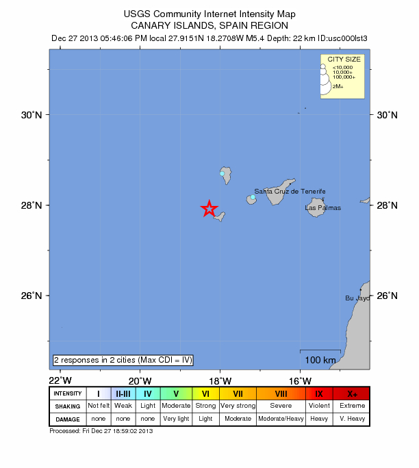
    5.4 magnitude earthquake shakes Canary Islands: one of the largest tremors ever
    December 27, 2013 – CANARY ISLANDS – Something is going on under El Hierro, and recent events suggest this time things could be dramatically different. Two years after a new underwater volcano appeared offshore of El Hierro in the Canary Islands, earthquake swarms and a sudden change in height suggest a new eruption is brewing near the island’s villages, officials announced today (Dec. 27). After the announcement, one of the largest temblors ever recorded at the volcanic island, a magnitude-5.4 earthquake, struck offshore of El Hierro at 12:46 p.m. ET (5:46 p.m. local time) today, the National Geographic Institute reported. Residents on the island reported strong shaking, and the quake was felt throughout the Canary Islands, according to news reports. The earthquake’s epicenter was 13 miles (22 kilometers) deep. Before the earthquake struck early this afternoon, the island’s volcano monitoring agency, Pelvolca, had raised the volcanic eruption risk for El Hierro to “yellow.” This warning means that activity is increasing at the volcano, but no eruption is imminent. A similar burst of activity prompted a yellow warning in June 2012, but the volcano soon quieted down. –TEP, LS


    _________________
    What is life?
    It is the flash of a firefly in the night, the breath of a buffalo in the wintertime. It is the little shadow which runs across the grass and loses itself in the sunset.

    With deepest respect ~ Aloha & Mahalo, Carol
    Carol
    Carol
    Admin
    Admin


    Posts : 31775
    Join date : 2010-04-07
    Location : Hawaii

    The Earthquake/Seismic Activity Log - Page 3 Empty Re: The Earthquake/Seismic Activity Log

    Post  Carol Thu Jan 30, 2014 9:51 pm

    Welcome to Britain's EARTHQUAKE capital: Sleepy Nottinghamshire town
    has been hit by 36 tremors in just 50 days - and geologists say mining is to blame
    Daily Mail - ‎Jan 29, 2014‎ The body added that there have been no reports of structural damage from mining-induced earthquakes in the UK for 40 years and the maximum observed has had a magnitude of around three.

    Read more: http://www.dailymail.co.uk/news/article-2548146/Welcome-Britains-EARTHQUAKE-capital-Sleepy-Nottinghamshire-town-hit-36-tremors-just-50-days-geologists-say-mining-blame.html#ixzz2rwczvGht


    _________________
    What is life?
    It is the flash of a firefly in the night, the breath of a buffalo in the wintertime. It is the little shadow which runs across the grass and loses itself in the sunset.

    With deepest respect ~ Aloha & Mahalo, Carol
    Carol
    Carol
    Admin
    Admin


    Posts : 31775
    Join date : 2010-04-07
    Location : Hawaii

    The Earthquake/Seismic Activity Log - Page 3 Empty Re: The Earthquake/Seismic Activity Log

    Post  Carol Thu Jan 30, 2014 10:34 pm

    The Earthquake/Seismic Activity Log - Page 3 1-27-14-Kefalonia-earthquake-map_full_380
    Kefalonia earthquake: Magnitude 5.8 temblor strikes Greek isle
    Kefalonia earthquake: Schools were closed Monday after Sunday's earthquake damaged homes and injured at least seven people. Kefalonia and nearby Zakinthos and Ithaki were devastated by massive earthquakes in 1953. Hundreds of the island's residents slept in their cars after a magnitude 5.8 temblor struck near the town of Lixouri on the western Greek island on Sunday, and was followed by dozens of aftershocks as powerful as magnitude 5.2, according to the Institute of Geodynamics in Athens. Seismologists noted it was too soon to tell whether the Sunday temblor, which the U.S. Geological Survey listed as having a 6.1 magnitude, was the main earthquake or whether a stronger one might strike in the following days.


    _________________
    What is life?
    It is the flash of a firefly in the night, the breath of a buffalo in the wintertime. It is the little shadow which runs across the grass and loses itself in the sunset.

    With deepest respect ~ Aloha & Mahalo, Carol
    mudra
    mudra


    Posts : 23223
    Join date : 2010-04-09
    Age : 69
    Location : belgium

    The Earthquake/Seismic Activity Log - Page 3 Empty Re: The Earthquake/Seismic Activity Log

    Post  mudra Wed Feb 12, 2014 2:39 pm

    2/12/2014 -- 6.8M Earthquake in Western China -- Major movement forecasted

    https://www.dailymotion.com/video/x1buy0l_2-12-2014-6-8m-earthquake-in-western-china-major-movement-forecasted_tech?search_algo=1


    Love Always
    mudra

      Current date/time is Sun May 12, 2024 11:37 pm