tMoA

Would you like to react to this message? Create an account in a few clicks or log in to continue.
tMoA

~ The only Home on the Web You'll ever need ~

+21
Aquaries1111
giovonni
arvan33
Floyd
lawlessline
JesterTerrestrial
THEeXchanger
newel
Brook
greybeard
Mercuriel
Sanicle
devakas
hobbit
mudra
burgundia
lindabaker
LeeEllisMusic
MargueriteBee
Carol
HigherLove
25 posters

    The Earthquake/Seismic Activity Log

    Carol
    Carol
    Admin
    Admin


    Posts : 31701
    Join date : 2010-04-07
    Location : Hawaii

    The Earthquake/Seismic Activity Log - Page 39 Empty Re: The Earthquake/Seismic Activity Log

    Post  Carol Mon Feb 18, 2013 9:03 am

    The Earthquake/Seismic Activity Log - Page 39 Kermadec_quake_2
    6.1 magnitude earthquake strikes Kermadec Islands
    February 18, 2013 – WELLINGTON, NZ — A 6.1 magnitude earthquake struck off New Zealand’s Kermadec Islands early Tuesday, the US Geological Survey reported. The quake hit at 12:19 am (1219 GMT Monday) at a depth of 34 km (21 miles), about 161 km south of Raoul Island in the Kermadecs. The largely uninhabited islands are northeast of New Zealand’s North Island. A magnitude 6.0 quake struck off North Island Saturday. A shallow 6.3-magnitude quake devastated the New Zealand city of Christchurch in the South Island in February last year, leaving 185 people dead.The country sits on the so-called “Ring of Fire”, the boundary of the Australian and Pacific tectonic plates, and experiences up to 15,000 tremors a year. This is the 21st –Inquirer


    4.9 magnitude earthquake creates panic in Central Italy
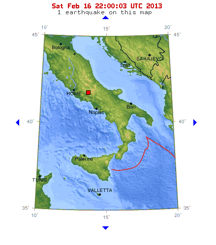
    The Earthquake/Seismic Activity Log - Page 39 Italy-2-16
    February 16, 2013 – ITALY – A 4.9 magnitude spooking quake hit central Italy late Saturday, shaking apartment buildings in the center of Rome, and citizens in the region of Abruzzo, struck by a killer quake in 2009. The earthquake hit Frosinone, between the capital and the southern city of Naples, at a depth of 10.7 kilometers according to Italy’s Geophysics Institute. No injuries or damage to buildings were reported. The tremor sparked panicked calls in the Abruzzo region to the emergency services. The medieval town of L’Aquila was hit in 2009 by a 6.3-magnitude quake which killed 309 people, and ruined buildings still scar the landscape. Inhabitants in villages in the national park in Abruzzo raced out of their houses in panic, according to Italian media reports. Earlier on Saturday, three Italian builders and a technician were found guilty of multiple manslaughter after a dormitory they had restored and safety approved collapsed during the L’Aquila quake, killing eight students. –News


    _________________
    What is life?
    It is the flash of a firefly in the night, the breath of a buffalo in the wintertime. It is the little shadow which runs across the grass and loses itself in the sunset.

    With deepest respect ~ Aloha & Mahalo, Carol
    Carol
    Carol
    Admin
    Admin


    Posts : 31701
    Join date : 2010-04-07
    Location : Hawaii

    The Earthquake/Seismic Activity Log - Page 39 Empty Re: The Earthquake/Seismic Activity Log

    Post  Carol Thu Feb 28, 2013 11:15 am


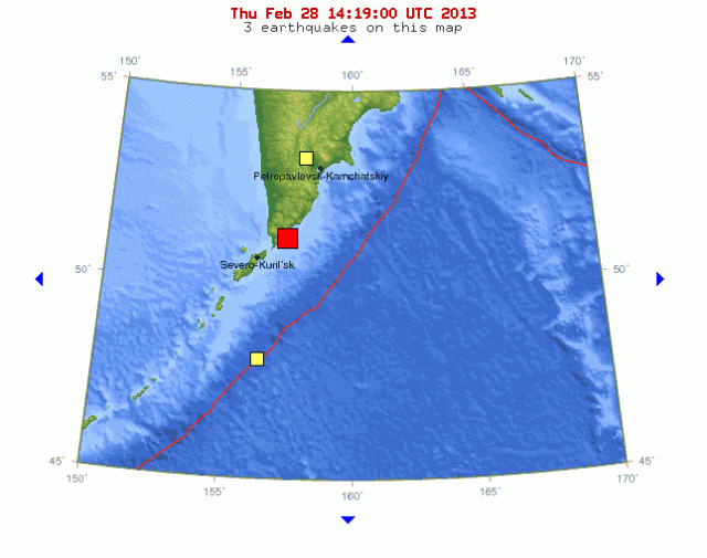
    The Earthquake/Seismic Activity Log - Page 39 S=1197546201&t=Zdx3QbvYc5
    http://rt.com/news/kurile-islands-earthquake-629/
    6.9 Earthquake Strikes Near Russia's Kamchatka Peninsula
    Earthquakes like the one that struck today can cause significant damage, especially with poorly built structures, and are sometimes followed by significant aftershocks. It's the second quake to hit the Kuril Islands this year. A magnitude 5.5 earthquake struck the Isles on January 1. The Islands were also hit with two earthquakes in November 2012, which measured magnitudes of 6.8 and 5.3. The Kuril Islands are located 90 kilometers (56 miles) from Severo-Kuril'sk, Russia. Tokyo is located 2,204 kilometers (1,369 miles) away from the Isles.

    The population of the Islands is around 19,000 people, and the total land area is about 15,600 square kilometers (6,000 square miles).


    _________________
    What is life?
    It is the flash of a firefly in the night, the breath of a buffalo in the wintertime. It is the little shadow which runs across the grass and loses itself in the sunset.

    With deepest respect ~ Aloha & Mahalo, Carol
    Carol
    Carol
    Admin
    Admin


    Posts : 31701
    Join date : 2010-04-07
    Location : Hawaii

    The Earthquake/Seismic Activity Log - Page 39 Empty Re: The Earthquake/Seismic Activity Log

    Post  Carol Thu Feb 28, 2013 11:20 am

    The Earthquake/Seismic Activity Log - Page 39 Kuril-quake-2-28
    Major earthquakes strike the Pacific Ring of Fire

    February 28, 2013 – KAMCHATKA – A magnitude 6.9 earthquake struck near the southern tip of Russia’s Kamchatka peninsula, at a depth of around 52 km (33 miles), the U.S. Geological Survey (USGS) reported on Thursday. The U.S. Pacific Tsunami Warning Center said there was no threat of a destructive widespread tsunami, based on historical earthquake and tsunami data. Britain’s BBC quoted Russia’s Emergencies Ministry as saying there were no reports of casualties or damage, and that no tsunami warning had been issued. The arc formed by the peninsula and the Kurile Islands stretching from Russia to Japan is one of the most seismically active areas in the world. USGS’s first report had put the quake at magnitude 7.0, at a depth of 18 miles. Today’s earthquake is the 24th major earthquake to strike the planet in the month of February. –Reuters, TEP

    Vanuatu: A strong 6.1-magnitude earthquake rattled the South Pacific island of Vanuatu Thursday, the US Geological Survey said, but it was not thought to have caused any damage or sparked a tsunami warning. Godwin Ligo, a reporter at the Trading Post newspaper, said he felt his office building in the capital Port Vila shake and sway. He said he wasn’t aware of any major problems caused by the quake. The shallow ocean quake struck at a depth of 15 kilometers (nine miles), 104 kilometers west of the capital Port Vila at 2.09 pm local time (0309 GMT). Geoscience Australia put its magnitude at 5.9 and said it was unlikely to have caused any damage. Vanuatu lies on the so-called “Pacific Ring of Fire,” a zone of frequent seismic activity caused by friction between shifting tectonic plates. It has been rocked by several large quakes in recent years, averaging about three magnitude 7.0 or above incidents annually, none of which have caused any major damage. –Geo

    5.1 magnitude earthquake strikes off the coast of Oregon February 28, 2013 – PORT ORFORD, Ore. — An earthquake has hit the ocean floor far off the Southern Oregon coast, but there were no immediate reports of anyone feeling it on land. The U.S. Geological Survey reports the magnitude 5.1 quake was 114 miles west northwest of Port Orford at 2:14 p.m. Wednesday. The epicenter was 6 miles deep. USGS spokeswoman Leslie Gordon says there were no immediate reports to the agency’s website from people feeling the quake on shore. –KGW


    _________________
    What is life?
    It is the flash of a firefly in the night, the breath of a buffalo in the wintertime. It is the little shadow which runs across the grass and loses itself in the sunset.

    With deepest respect ~ Aloha & Mahalo, Carol
    Carol
    Carol
    Admin
    Admin


    Posts : 31701
    Join date : 2010-04-07
    Location : Hawaii

    The Earthquake/Seismic Activity Log - Page 39 Empty Re: The Earthquake/Seismic Activity Log

    Post  Carol Fri Mar 08, 2013 12:55 am

    Upcoming earthquake windows:

    The OFFICIAL GCM of 188 2013 updated PRELIMINARY QUAKE WARNING with all the KEY DATES & windows for ALL Major Quakes in January, February, March, April & May 2013


    ===============================
    January

    1/16 to 1/18...... 7+

    -----------------------------------
    February

    2/4....... 6.8+ to 7.4+

    2/7....... 6.8+ to 7.8+

    2/14.....

    2/19 - 2/23...... 6.8+ to 7.8+

    2/26 - 2/27...... 7.1+ to 8.1+

    -------------------------------------
    March

    3/3 - 3/6...... 7.1+ to 8.1+

    3/11 - 3/13...... 6.8+ to 7.8+

    ***3/20 - 3/22...... 7.2+ to 8.8+ possible 9+ - Spring Equinox

    ***3/28 - 3/30....... 6.8+ to 7.8+

    -------------------------------------
    April

    ***4/2 - 4/6...... 6.8+ to 7.7+

    ***4/11 - 4/13..... 6.8+ to 8.1+

    4/20 - 4/22..... 6.8+ to 7.5+

    4/25 - 4/28...... 7.1+ to 8.8+ possible 9+

    -------------------------------------
    May

    5/1...... 6.8+ to 7.3+

    5/5...... 6.8+ to 7.7+

    5/8...... 7.2+ to 8.2+

    5/10 - 5/12..... 7.1+ to 8.3+

    5/23 - 5/25..... 7.2+ to 8.7+ possible 9+

    5/28...... 7.4+ to 8.4+


    ________________________________
    ALL dates +-1 day

    188 Cycle Target dates 3/30 to 4/02

    *** Denotes 188 CYCLE Fluctuation/proximity


    _________________
    What is life?
    It is the flash of a firefly in the night, the breath of a buffalo in the wintertime. It is the little shadow which runs across the grass and loses itself in the sunset.

    With deepest respect ~ Aloha & Mahalo, Carol
    Carol
    Carol
    Admin
    Admin


    Posts : 31701
    Join date : 2010-04-07
    Location : Hawaii

    The Earthquake/Seismic Activity Log - Page 39 Empty Re: The Earthquake/Seismic Activity Log

    Post  Carol Sun Mar 10, 2013 8:56 pm

    March 11, 2013 – PAPUA, NG – A magnitude 6.7 (6.5 USGS) earthquake has struck off Papua New Guinea’s north coast city of Lae, the United States Geological Survey said on Monday. The quake, about 150 km (95 miles) east of Lae, was initially recorded at a depth of about 20 km, although that figure was later revised to 87 km. The Pacific Tsunami Warning Center said there was no Pacific-wide tsunami threat. –Reuters

    Alaska rattled by quake: Authorities in Alaska say an earthquake with a preliminary magnitude of 4.0 was felt in Anchorage and areas to the northwest. The Alaska Earthquake Information Center reports that the quake struck shortly after 1 p.m. on Sunday. It was centered 28 miles northwest of Anchorage. The quake was felt throughout the Cook Inlet region. There were no reports of damage. -ABC


    _________________
    What is life?
    It is the flash of a firefly in the night, the breath of a buffalo in the wintertime. It is the little shadow which runs across the grass and loses itself in the sunset.

    With deepest respect ~ Aloha & Mahalo, Carol
    Carol
    Carol
    Admin
    Admin


    Posts : 31701
    Join date : 2010-04-07
    Location : Hawaii

    The Earthquake/Seismic Activity Log - Page 39 Empty Re: The Earthquake/Seismic Activity Log

    Post  Carol Tue Mar 12, 2013 10:48 am

    4.7 magnitude quake shakes Los Angeles:
    residents told to prep for 2 weeks and be prepared for disasters
    March 12, 2013 – LOS ANGELES, CA – An earthquake with a magnitude of 4.7 was reported in Anza, California. The quake was the first of several that popped up at the same time Monday on the U.S. Geological Survey website. It was originally reported as a 5.2 magnitude quake but was then downgraded. The epicenter for the 9:56 a.m. quake was 12 miles east of Anza and 16 miles southwest of Palm Desert. Near the epicenter, Palms Springs police Sgt. Harvey Reed told the Associated Press his department received no reports of damage or injuries. There were no other immediate reports of damage in the region. It happened along the San Jacinto fault between the San Andreas and the Elsinore faults. This is a fault famous for big earthquakes according to retired geology professor Pat Abbott, Ph.D. “There’s always that slight chance – slight chance now – that this could be the foreshock of something larger. Probably not. Usually this is just an event all by itself,” Abbot said. “It doesn’t hurt to keep it in mind, in the next 72 hours in particular,” he said. “If a larger one is going to occur it would probably be during that three-day period.” Residents were urged to prepare for a number of disaster scenarios, including how to cope for being at least “two weeks on your own. The message for a lot of us needs to be, ‘Be ready for anything’,” said Battalion Chief Larry Collins. “The message used to be 72 hours, but we’ve seen in disasters like [Hurricane] Katrina, even [Hurricane] Sandy recently, that, really, if it’s wiped out your infrastructure, and your electricity grid and your communications, it will be very likely be more than three days before you start getting food, water and other supplies coming in from outside.” –CBS NBC

    Magnitude 5.2
    Date-Time

    Monday, March 11, 2013 at 16:55:42 UTC
    Monday, March 11, 2013 at 09:55:42 AM at epicenter

    Location 33.506°N, 116.476°W
    Depth 0.1 km (~0.1 mile) (poorly constrained)
    Region SOUTHERN CALIFORNIA
    Distances

    19 km (12 miles) ESE (107°) from Anza, CA
    25 km (16 miles) SW (221°) from La Quinta, CA
    26 km (16 miles) SSW (202°) from Palm Desert, CA
    36 km (22 miles) S (172°) from Palm Springs, CA
    102 km (63 miles) NE (38°) from San Diego, CA

    New Madrid quake: A small earthquake measuring 2.7 magnitude hit near Benton in southern Illinois this morning but appears to have done little, if any, damage in the rural area. The quake occurred around 5 a.m. about 11 miles east of where Interstate 57 passes through Benton, the seat of Franklin County, according to the U.S. Geological Survey. The closest town is Macedonia, population 50. The Franklin County sheriff’s office said it had gotten no reports of injuries or damages. The quake hit to the north and west of what is called the New Madrid seismic zone. Strong earthquakes from the New Madrid fault and other faults in what’s known as the Illinois Basin-Ozark Dome area have hit southern Illinois and nearby parts of Missouri, Arkansas, Indiana and Kentucky over the years, including a series of devastating quakes in 1811 and 1812. The largest earthquake in the area in memory was in 1968 and registered a 5.4 magnitude, what the geological survey calls a moderately damaging quake. The last strong earthquake to hit southern Illinois was in April 2008, when a 5.2 magnitude quake struck near West Salem, affecting areas including Mount Carmel, about 80 miles east of Benton. –Chicago Tribune

    Seismic watch: The planet has now entered a window of elevated risks for a major earthquake to strike somewhere on the planet from now, through March 23, 2013. People in seismically high-risk regions should remain alert and prepared for the potential occurrence or occurrences of seismic events and their associated hazards. –The Extinction Protocol

    _________________
    What is life?
    It is the flash of a firefly in the night, the breath of a buffalo in the wintertime. It is the little shadow which runs across the grass and loses itself in the sunset.

    With deepest respect ~ Aloha & Mahalo, Carol
    Carol
    Carol
    Admin
    Admin


    Posts : 31701
    Join date : 2010-04-07
    Location : Hawaii

    The Earthquake/Seismic Activity Log - Page 39 Empty Re: The Earthquake/Seismic Activity Log

    Post  Carol Thu Mar 21, 2013 11:13 am

    The Earthquake/Seismic Activity Log - Page 39 Nankai_plates
    Study warns a Nankai trench earthquake would displace 10 million people in Japan, and kill 323,000
    The Earthquake/Seismic Activity Log - Page 39 Japan-tsunami-earthquake-hits-northeast-whirlpool_33139_600x450
    March 20, 2013 – JAPAN – A Japanese government panel is estimating that a 9.0 magnitude earthquake in the Nankai Trough region will do damage worth $2.2 billion, a figure that is much higher than the $177 million from the Great East Japan Earthquake of 2011. Scientists are predicting that the earthquake is due “in the not-too-distant future”, based on historical rough calculations. These figures do not include the possible nuclear fallout from an earthquake of that magnitude. The panel also predicts the number of evacuees to reach 9.5 million a week after it hits and that 40 out of the country’s 47 prefectures will suffer damage to their infrastructure. 27.1 million will suffer power outages, while 34.4 million will be without water. In an earlier report released in August, the panel said around 323,000 could die from an earthquake with its epicenter in the Nankai Trough, also a big number compared to the 19,000 who died or were reported missing in the 2011 disasters. But if all houses and key buildings are already quake-resistant by the time the earthquake will occur, the damage can be cut to almost half at $836 million. That is why the government’s priority would be to come up with basic policy measures by the end of the month against future earthquakes. The Nankai trough runs from the gulf of Suruga, Shizuoka Prefecture, central Japan, to the sea of Hyuga, off Miyazaki Prefecture in the southwestern Japan region of Kyushu. Historically, this area experiences 8.0 magnitude earthquakes once every 100 to 150 years, with the last one occurring last 1946, where around 1,330 people perished. –JDP

    Is Japan flirting with disaster in new energy source? Japan Oil, Gas and Metals National Corporation, a Japanese state-owned prospecting company says it has successfully extracted methane gas from an undersea methane hydrate deposit in the Nankai trench south of Japan’s main island of Honshu. This marks the first successful extraction of methane from such deep sea deposits. The team expects their pilot rig could extract up to 10,000 cubic meters of methane gas per day. Deep sea methane hydrates could supply Japan’s energy needs for 100 years. For a resource-poor country still recovering from the aftermath of the March 2011 tsunami and Fukushima nuclear disaster, this sounds almost too good to be true. But methane hydrate mining carries unique risks which could make this one of the most dangerous sources of energy. Methane hydrates are also called methane clathrates. They consist of molecules of methane (CH4) trapped in a crystalline cage of water (H2O) molecules. The substance somewhat resembles water ice but it forms only under the extremely high pressures and cold temperatures of the deep ocean floor and, unlike water ice, methane hydrate ice is flammable and prone to explosive sublimation. Extracting methane (the primary component in natural gas) from methane hydrates is difficult because such deposits only occur in very deep water. The Japanese drilling ship Chikyu, also called Godzilla-maru for its enormous size and 100 meter tall drilling derrek, performed its methane extraction about 50 miles offshore from Japan’s Atsumi peninsula 300 meters (1000 feet) beneath the Pacific’s surface. Mining methane hydrates is risky because these are unstable solids. It is possible that BP’s 2010 deepwater horizon blow out which dumped millions of barrels of oil into the Gulf of Mexico was triggered by the explosive sublimation of a methane hydrate deposit. It is also possible that mining methane hydrates near the edge of continental slopes may cause landslides and trigger tsunamis. A third risk of methane hydrates is their global warming potential. Any methane escaping from such deposits is 21 times more powerful than CO2 as a greenhouse gas. Burning the methane trapped in undersea deposits would release twice as much carbon dioxide as all of the world’s coal, oil, oil-shale and gas deposits. Given Japan’s energy shortage it is understandable that its government might want to explore risky options such as undersea methane hydrate deposits, but we need to carefully weigh the risks against the benefits. –Green Prophet


    _________________
    What is life?
    It is the flash of a firefly in the night, the breath of a buffalo in the wintertime. It is the little shadow which runs across the grass and loses itself in the sunset.

    With deepest respect ~ Aloha & Mahalo, Carol
    Carol
    Carol
    Admin
    Admin


    Posts : 31701
    Join date : 2010-04-07
    Location : Hawaii

    The Earthquake/Seismic Activity Log - Page 39 Empty Re: The Earthquake/Seismic Activity Log

    Post  Carol Thu Mar 21, 2013 11:15 am


    19 miners rescued in Poland, after earthquake causes mine collapse
    March 20, 2013 – POLAND - Emergency services in western Poland have rescued 19 miners who were trapped underground when a minor earthquake caused a tunnel to collapse. The workers at Rudna copper mine in Lower Silesia were trapped for about eight hours while rescuers dug through earth and rock to reach them. The mine is owned by Poland’s largest copper miner, KGHM, and has operated since 1969. A KGHM spokesman said the accident happened 600m (2,000ft) below ground. He said the rescue operation was “difficult because huge amounts of rocks have to be removed.” The tremor that caused the tunnel to collapse, lasted about 10 seconds, the BBC’s Adam Easton reports from the capital, Warsaw. One miner had a gash on his head, but all those who were rescued were fit enough to go home. The mine is some 400km (250 miles) south-west of Warsaw. Accidents there are relatively uncommon. Poland has a large number of mines, many of which are located in the industrialized Silesia region, which is rich in mineral and natural resources. –BBC http://www.bbc.co.uk/news/world-europe-21854873


    _________________
    What is life?
    It is the flash of a firefly in the night, the breath of a buffalo in the wintertime. It is the little shadow which runs across the grass and loses itself in the sunset.

    With deepest respect ~ Aloha & Mahalo, Carol
    Carol
    Carol
    Admin
    Admin


    Posts : 31701
    Join date : 2010-04-07
    Location : Hawaii

    The Earthquake/Seismic Activity Log - Page 39 Empty Re: The Earthquake/Seismic Activity Log

    Post  Carol Thu Mar 21, 2013 11:18 am


    Spreading? Mysterious tremors rattle homes in South Jersey
    The Earthquake/Seismic Activity Log - Page 39 Images?q=tbn:ANd9GcQsqkDgN54726u_ry0esy76KTuh7K5BIsf9xK_qCau7W2Szq1hKZA
    March 21, 2013 – SOUTHERN NEW JERSEY - Just after 3 o’clock Tuesday afternoon residents in Atlantic, Cape May, and Cumberland counties say they felt multiple earthquake-like tremors that rattled their homes and offices. Absecon resident, Kay Stadlmeir, said, “I don’t think it would be an earthquake, but what could it be? It’s just really odd.” Somers Point resident, Bob Mower, explained, “There was a rattling of my windows and I felt the house shake just a little bit – it was unusual.” Stadlmeir told NBC40, “It has to be something really big to be witnessed in such a widespread area of South Jersey.” The reports vary from region to region. Atlantic county emergency management officials confirmed with the U.S. Geological Survey that it was not an earthquake. The next thought was that military training or an aircraft flying by might have caused the shakes. Both the 177th Fighter Wing in Egg Harbor Township and Joint Base McGuire-Dix-Lakehurst confirmed none of their aircrafts were in the area at that time. Joint Base McGuire-Dix-Lakehurst is still working to confirm whether or not any ground training was happening at the time, although it is unlikely that would cause such a widespread shake. Stadlmeir said, “I really don’t think it’s a sonic boom because, you know as I said before, I’ve experienced them before and this is nothing like that.” Mower told NBC40, “That was real unusual. I almost wondered if I was dreaming on that one.” After initial reports of the shakes came in, NBC40 put the word out on Facebook to see who else felt it. Immediately we received hundreds of responses from all over South Jersey. Concerned Egg Harbor Township resident, Oliana Collado, said, “I just think it’s weird because some people didn’t feel it and it’s like in random spots, and it’s very spread out. Yeah it was scary, but I’m just glad it wasn’t worse than what it was.” When we reached out to New Jersey State Police Headquarters, we were told that our call marked the first time they had heard about possible tremors and they were unable to tell us anything further. NBC40 will continue to investigate the cause of these mysterious tremors. –NBC40 http://www.nbc40.net/story/21723567/tremors-a-mystery-in-south-jersey

    The Earthquake/Seismic Activity Log - Page 39 2353679_G


    _________________
    What is life?
    It is the flash of a firefly in the night, the breath of a buffalo in the wintertime. It is the little shadow which runs across the grass and loses itself in the sunset.

    With deepest respect ~ Aloha & Mahalo, Carol
    Carol
    Carol
    Admin
    Admin


    Posts : 31701
    Join date : 2010-04-07
    Location : Hawaii

    The Earthquake/Seismic Activity Log - Page 39 Empty Re: The Earthquake/Seismic Activity Log

    Post  Carol Sat Mar 23, 2013 7:23 pm

    2013-03-23 23:55 UTC
    - Almost midnight UTC and the counter shows 164 volcanic earthquakes, the most active day of the current crisis
    - The latest 20 listed earthquakes are gradually deeper again, mainly by the migration of the epicenters towards the south (lighthouse area). Focal depth of hypocenters is now ranging in between 16 en 17 km.
    - The frequency and strength of the earthquakes has somewhat weakened the last couple of hours, but remains still strong


    _________________
    What is life?
    It is the flash of a firefly in the night, the breath of a buffalo in the wintertime. It is the little shadow which runs across the grass and loses itself in the sunset.

    With deepest respect ~ Aloha & Mahalo, Carol
    Carol
    Carol
    Admin
    Admin


    Posts : 31701
    Join date : 2010-04-07
    Location : Hawaii

    The Earthquake/Seismic Activity Log - Page 39 Empty Re: The Earthquake/Seismic Activity Log
    Post  Carol Tue Mar 26, 2013 12:50 pm

    The Earthquake/Seismic Activity Log - Page 39 Mexico-march-26
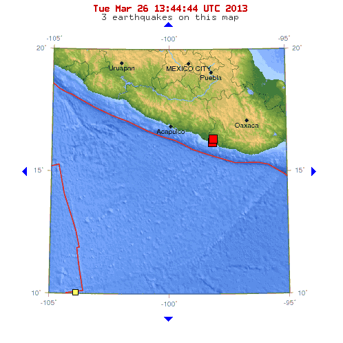
    Moderate earthquakes strike southern region of Mexico
    March 26, 2013 – MEXICO CITY — Earthquakes shook Mexico City on Tuesday, causing buildings to sway in the capital and sending thousands fleeing into the streets, as an earthquake alarm sounded. There were no immediate reports of damages or injuries. Mexico Seismology Service said the quake had a magnitude of 5.9 (5.5 USGS) and was centered about 30 miles (50 kilometers) southwest of Pinotepa Nacional on the Pacific Coast. The earthquake was followed by a 5.1 magnitude aftershock. –Huffington Post

    The Earthquake/Seismic Activity Log - Page 39 El-Hierro-New-Erruptions-300x195
    4.1 magnitude earthquake shakes El Hierro, in Canary Islands
    March 26, 2013 – CANARY ISLANDS - An earthquake measuring 4.1 on the Richter scale shook El Hierro island in Spain’s Canaries on Monday, the strongest of hundreds of tremors which have plagued the island, which suffered an undersea volcanic eruption in 2011, Spain’s National Geographical Institute said Monday. The earthquake struck at 3:41 pm (1441 GMT) and its epicenter was in the Atlantic

    Ocean about 12 kilometers (7.5 miles) west of the island, a spokesman for the institute said. It was measured at a depth of 16 kilometers and was preceded by another earthquake measuring 4.0 on the Richter scale. About 800 earthquakes have been recorded in El Hierro, which has about 10,000 inhabitants, since March 18, the spokesman added. The majority of the quakes have measured above 2.0 on the Richter but only a handful has been strong enough for people on the island to notice. In October 2011 an underwater volcano erupted off the coast of El Hierro, two days after an earthquake measuring 4.3 on the Richter scale rocked the island. El Hierro, which means “Iron” in Spanish, suffered thousands of earthquakes throughout much of 2011, only a few of them, prompting officials to briefly close a tunnel linking the island’s two main towns — Frontera and

    Valverde — and evacuate dozens of people over fears of landslides. The Canary Islands are located off the northwestern coast of Africa. El Hierro, which has an area of just 267 square kilometers (103 square miles) is the westernmost of the seven islands of volcanic origin that make up the archipelago. The last eruption occurred off the Canary Islands, happened off Teneguia, Las Palamas, in 1971. –Global Post

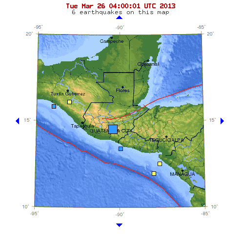
    The Earthquake/Seismic Activity Log - Page 39 Guatemala-march-25
    March 26, 2013 – GUATEMALA – A powerful 6.2 earthquake struck Guatemala close to the capital on Monday, though residents of Guatemala City felt little movement from the deep tremor and emergency services said there were no initial reports of damage or injuries. The epicenter of the 6.2 magnitude earthquake, initially reported as a magnitude 5.8, was only 6 miles southeast of Guatemala City but it was at a depth of 124.6 miles, lessening its effect. Two Reuters witnesses in the city said they did not feel the quake, nor did they see people running outdoors as is often the case when powerful tremors hit. David de Leon, a spokesman for Guatemala’s emergency agency, CONRED, said he had no reports of damage or victims. A magnitude 6.2 quake is capable of causing severe damage. Last November, more than 50 people were killed in a 7.5 magnitude quake in Guatemala in San Marcos state, a mountainous region near the Mexican border. That earthquake was the strongest to shake the country since 1976, when a magnitude 7.5 quake centered about 99 miles northeast of Guatemala City killed some 23,000 people. -Reuters


    _________________
    What is life?
    It is the flash of a firefly in the night, the breath of a buffalo in the wintertime. It is the little shadow which runs across the grass and loses itself in the sunset.

    With deepest respect ~ Aloha & Mahalo, Carol
    Carol
    Carol
    Admin
    Admin


    Posts : 31701
    Join date : 2010-04-07
    Location : Hawaii

    The Earthquake/Seismic Activity Log - Page 39 Empty Re: The Earthquake/Seismic Activity Log

    Post  Carol Wed Mar 27, 2013 9:24 am

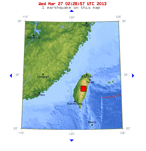
    The Earthquake/Seismic Activity Log - Page 39 Taiwan-march-26
    6.0 magnitude earthquake shakes buildings in Taipei
    March 27, 2013 – TAIPEI - A powerful earthquake measured at 6.0 magnitude by seismologists shook buildings in Taipei on Wednesday but there were with no immediate reports of damage or casualties. The quake struck at 10:03 am (0203 GMT) in Nantou county in central Taiwan, at a depth of 15 kilometers, the central weather bureau said. It is the fourth 6.0+ magnitude earthquake to strike the planet in 4 days. -Inquirer


    _________________
    What is life?
    It is the flash of a firefly in the night, the breath of a buffalo in the wintertime. It is the little shadow which runs across the grass and loses itself in the sunset.

    With deepest respect ~ Aloha & Mahalo, Carol
    Carol
    Carol
    Admin
    Admin


    Posts : 31701
    Join date : 2010-04-07
    Location : Hawaii

    The Earthquake/Seismic Activity Log - Page 39 Empty Re: The Earthquake/Seismic Activity Log

    Post  Carol Sat Apr 06, 2013 10:41 am

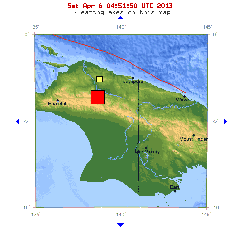
    The Earthquake/Seismic Activity Log - Page 39 Indonesia-4-6
    7.0 magnitude earthquake strikes Papua region of eastern Indonesia
    April 6, 2013 – INDONESIA – An earthquake measuring 7.2 Richter scale rocked Papua in eastern parts of Indonesia on Saturday, but no initial reports of damage or casualty, officials said here. The USGS reported the quake was at 7.0 magnitude with the depth at 68 km. The quake struck at 11:42 a.m. Jakarta time with epicenter at 56 km northeast Tolikara of Papua and with the depth at 173 km under land, an official of the Indonesian Meteorology and Geophysics Agency told Xinhua by phone. The intensity of the quake was felt at 4 MMI (Modified Mercally Intensity) in Wamena, Tanah Merah, Sentani, Jayapura and 2 MMI in Timika, the official said. Spokesman of National Disaster Management and Mitigation Agency Sutopo Purwonugroho said that there were no reports of buildings collapsed or those injured or fatality. “But the assessment on the impact of the quake keeps continuing,” he told Xinhua by phone. Indonesia sits on a vulnerable quake hit zone so called “the Pacific Ring of Fire.” –CRI


    The Earthquake/Seismic Activity Log - Page 39 Images?q=tbn:ANd9GcQXW_UWaVvvnZEBioCDiAGuHGtCB-y_GkntgTh8ptlzdpRb3EuG
    U.S. seismic expert urges Jamaica to prepare for major earthquake
    April 6, 2013 – JAMAICA - Authorities in Jamaica have been urged by an American seismic expert to start long-term efforts to prepare for another major earthquake to impact the island. The advice came from geophysics professor Eric Calais of Purdue University, who urged the country’s government and various stakeholders to understand that the threat is very real based on the area’s history and active seismic activity. Professor Calais, who visited the island as part of a mission with the United Nations Development Program (UNDP), said most scientists agree that Jamaica will most likely be exposed to an earthquake with a magnitude of 7 or 7.5 on the Richter scale. An earthquake of magnitude 7 on the Richter scale is considered “major” and is capable of widespread destruction. Kingston was destroyed, with some 1,000 resultant deaths, in a 6.5-magnitude quake in 1907. If Jamaica were to be hit by a similar quake now, the island could suffer a $6.5 billion loss, nearly half of the island’s gross domestic product, researchers with the University of the West Indies (UWI) have said. “A 6.5 in the harbor by the capital could be a tremendous threat,” Calais said during a visit to Port Royal, just outside of Kingston, which was the island’s main city until 1692 when an earthquake and tsunami submerged two-thirds of the town. While it is impossible to predict whether the next big quake will strike in days or decades, Calais’ advice is particularly noteworthy given that in March 2008 he was among a group of scientists who warned officials in Haiti that their country was ripe for a major earthquake after detecting signs of growing stresses in a fault. Just two years later, that fault unleashed the deadly 7.0 quake that devastated the French-speaking Caribbean nation, killing some 316,000 people and leaving many more homeless. Calais pointed out that Jamaica is located along the same seismically-active plate boundary as Haiti and experiences about 200 mostly minor earthquakes per year. While indicating that Jamaica has a “good foundation” to tackle risks, especially when compared to Haiti, the American seismologist added a cautionary note. “But at the same time, I think it’s important to realize the foundation is not at the level that’s sufficient to face a challenge of a possible magnitude seven or seven-and-a-half,” he said. Calais further noted that he does not believe that the level of hazard has changed in Jamaica since the 2010 quake that levelled Haiti’s capital Port-au-Prince. –Caribbean 360


    The Earthquake/Seismic Activity Log - Page 39 Oooooooore.si
    6.2 magnitude earthquake shakes Russia’s far east, close to China and North Korea
    April 5, 2013 – NORTH KOREA – An earthquake of 6.2 magnitude was registered in the border area between Russia, China and North Korea, the US Geological Survey said Friday. The epicenter of the quake was 9km from the Russian village of Zarubino, about 60km northeast of the North Korean city of Aodzhiri and approximately 608 km from the capital Pyongyang. No casualties or damage have been reported. The earthquake struck at a depth of 561.9 km. –RT


    _________________
    What is life?
    It is the flash of a firefly in the night, the breath of a buffalo in the wintertime. It is the little shadow which runs across the grass and loses itself in the sunset.

    With deepest respect ~ Aloha & Mahalo, Carol
    Carol
    Carol
    Admin
    Admin


    Posts : 31701
    Join date : 2010-04-07
    Location : Hawaii

    The Earthquake/Seismic Activity Log - Page 39 Empty Re: The Earthquake/Seismic Activity Log

    Post  Carol Sat Apr 06, 2013 10:43 am

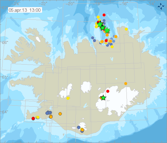
    The Earthquake/Seismic Activity Log - Page 39 Iceland
    Geologists mystified by significance of new swarm of tremors rattling Iceland
    The Earthquake/Seismic Activity Log - Page 39 Graph
    April 5, 2013 – ICELAND - Approximately 70 earthquakes were picked up by the automatic sensors of the Icelandic Met Office in the Grímsey Island seismic belt in North Iceland from midnight yesterday and until the morning. The activity started with a 5.5 quake on April 2. Some of last night’s quakes were of a magnitude higher than three but none measured above four points, ruv.is reports. Yesterday, around 70 earthquakes were registered from noon and until the evening, five of which were above three in magnitude. The quakes could be felt on Grímsey but not on the mainland. Seismologists are paying close attention to the epicenter of the earthquakes at Skjálfandadjúp. So far, there are no indications that the activity is spreading to other fracture zones and the condition was stable yesterday. A level of uncertainty was declared in North Iceland following the 5.5 earthquake and the region’s residents were asked to inform themselves on how to react in case of a major earthquake. –Iceland Review

    More than 800 quakes: An earthquake swarm continues to shake North Iceland, home to one of the world’s largest and most active series of volcanoes. More than 800 quakes have rattled island residents, a number that’s probably already out-of-date. About 40 to 60 earthquakes hit every hour on April 2 and 3, according to the Iceland Geology Blog. Some smaller quakes preceded the biggest event, a magnitude 5.5 shaker that struck offshore Grimsey Island on April 2. The latest swarm moved about 9 to 12 miles (15 to 20 kilometers) south of the biggest temblor, said Iceland’s Meteorological Office. Another large quake, a magnitude 4.7, struck early this morning (April 4) in this southerly spot. –Live Science


    _________________
    What is life?
    It is the flash of a firefly in the night, the breath of a buffalo in the wintertime. It is the little shadow which runs across the grass and loses itself in the sunset.

    With deepest respect ~ Aloha & Mahalo, Carol
    Carol
    Carol
    Admin
    Admin


    Posts : 31701
    Join date : 2010-04-07
    Location : Hawaii

    The Earthquake/Seismic Activity Log - Page 39 Empty Re: The Earthquake/Seismic Activity Log

    Post  Carol Tue Apr 09, 2013 12:52 am

    The Earthquake/Seismic Activity Log - Page 39 Images?q=tbn:ANd9GcQEVtbd6Qhjf4c6f3Nqm2zWRYlGx_EdYDsIkNWa0Eg1UmMDCZp6Lw
    http://www.wpsdlocal6.com/home/ticker/Earthquakes-rattle-nerves-in-local-area-201703811.html
    Earthquakes rattle nerves in local area: Is New Madrid waking up?
    April 8, 2013 – PEMISCOT COUNTY, MO. – On shaky ground. Two tremors in the New Madrid Seismic Zone this week have people wondering if a big earthquake could be coming. The two are considered minor. No damage has been reported from either. Thursday night’s quake struck around 7:27 local time. It was centered about six miles northeast of Caruthersville, Missouri and measured a 2.7 on the Richter Scale. Tuesday night a similar quake hit near Portageville, Missouri. The U.S. Geological Survey considers the New Madrid Seismic Zone the most active in North America east of the Rockies. But it’s been about 100 years since a major earthquake hit this area. Still, the two recent quakes are leaving behind some rattled nerves. The only thing getting shaken Friday in Caruthersville, Missouri is the salad at Grandad’s Deli. “It’s a scary thought,” said Sharon Russell, owner. Russell said they were busy Thursday night and didn’t notice the tremor. “We were kind of rocking in this little place last night, so we didn’t feel it,” she said. But now, the week’s two tremors are the talk of the town. Alexis Avis shook with the first. “The first one I felt, I was in bed. And I thought I could tell it was an earthquake,” she said. Avis said the two so close together put her on alert. “New Madrid is always putting out a lot of small ones,” said Dr. James Conder, Assistant Professor of Geology at SIU-Carbondale. Dr. Conder believes there’s really no reason for alarm but said it’s natural for people to wonder. “It really should spark some curiosity,” he said. Dr. Conder said some evidence shows the New Madrid may be running out of energy, and the recent quakes are its last breaths. But that’s just a theory. He warns a larger one could hit at any time. If it does, the damage region-wide could be catastrophic. “We have very thick soils that shake like Jello, everything would get bounced around a lot,” said Conder. That’s a circumstance Sharon Russell doesn’t want to consider. “How big does it have to be before you really feel the effects of it?” said Russell. Professor Conder said researchers would become concerned if the frequency and intensity of those quakes increases in months and years to come. -WPSD


    _________________
    What is life?
    It is the flash of a firefly in the night, the breath of a buffalo in the wintertime. It is the little shadow which runs across the grass and loses itself in the sunset.

    With deepest respect ~ Aloha & Mahalo, Carol
    Carol
    Carol
    Admin
    Admin


    Posts : 31701
    Join date : 2010-04-07
    Location : Hawaii

    The Earthquake/Seismic Activity Log - Page 39 Empty Re: The Earthquake/Seismic Activity Log

    Post  Carol Tue Apr 09, 2013 1:19 pm

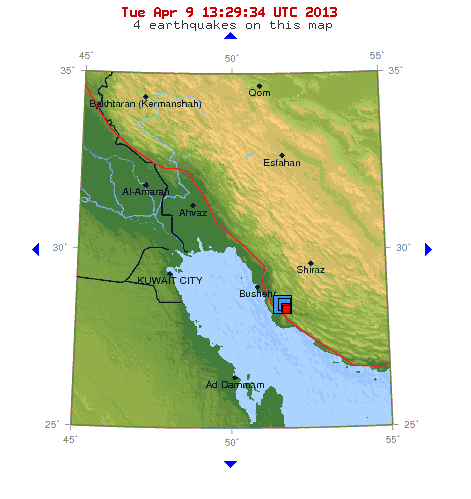
    The Earthquake/Seismic Activity Log - Page 39 Iran-4-9
    Shallow 6.3 magnitude earthquake strikes southern Iran, near nuclear plant: 4 dead
    April 9, 2013 – TEHRAN, Iran (AP) — Iran’s state TV is reporting that a 6.3 magnitude earthquake has jolted a town in the country’s south. The Tuesday report by the English-language channel Press TV says the earthquake struck Khormooj some 80 kilometers southeast of Bushehr, the home of Iran’s first nuclear power plant. There were no immediate reports of casualties or damage. Another report by semi-official Fars news agency says fearful residents poured into the streets. The quake was felt across the Gulf in Bahrain and Qatar, where workers were evacuated from high-rise buildings as a precaution. Earlier on Sunday a lighter earthquake jolted Khormooj. Iran is located on seismic faults and it experiences daily light earthquakes. In 2003, some 26,000 people were killed by a 6.6 magnitude quake that flattened the historic southeastern city of Bam. -G

    Quake strikes near nuclear plant: A 6.3 magnitude earthquake has struck in south-west Iran, not far from the country’s only nuclear power station, the US Geological Survey (USGS) says. Initial reports on state media say four people have died. Posts on social media in the region said people felt the quake across the Gulf in Dubai, Abu Dhabi and Bahrain. Iran’s nuclear program has roused concern among major powers that Tehran wants to build nuclear weapons – a charge Iran strongly denies. The USGS said the quake struck at 11:52 GMT at a depth of 10km (6.2 miles), some 90km from Bushehr city, near to the power plant. Iran’s seismological centre in Bushehr province, linked to Tehran University, registered a 6.1 magnitude quake close to the town of Kaki, some 60 miles south of Bushehr. More than five aftershocks have been felt so far, the strongest measuring a magnitude of 5.4. The Russian contractor which built the Bushehr plant says it has not been affected by the earthquake, says Russian news agency Interfax. Staff at the complex felt the jolts but continue to work as usual, while radiation levels have not changed, an unnamed Atomstroyexport official told Interfax. –BBC

    Aljazeera.com
    Iran quake kills 30, injures hundreds
    CNN International - (CNN) -- A powerful earthquake struck southern Iran on Tuesday, killing at least 32 people but apparently sparing the nearby Bushehr nuclear plant from any damage, Iranian state media reported.
    http://edition.cnn.com/2013/04/09/world/meast/iran-earthquake/?hpt=hp_t3


    Minor earthquake – Poland on April 9, 2013
    Most important Earthquake Data:
    Magnitude : 3
    Local Time (conversion only below land) : 2013-04-09 18:08:17
    GMT/UTC Time : 2013-04-09 16:08:17
    Depth (Hypocenter) : 10 km
    http://earthquake-report.com/2013/04/09/minor-earthquake-poland-on-april-9-2013/


    _________________
    What is life?
    It is the flash of a firefly in the night, the breath of a buffalo in the wintertime. It is the little shadow which runs across the grass and loses itself in the sunset.

    With deepest respect ~ Aloha & Mahalo, Carol
    Carol
    Carol
    Admin
    Admin


    Posts : 31701
    Join date : 2010-04-07
    Location : Hawaii

    The Earthquake/Seismic Activity Log - Page 39 Empty Re: The Earthquake/Seismic Activity Log

    Post  Carol Mon Apr 15, 2013 9:46 am

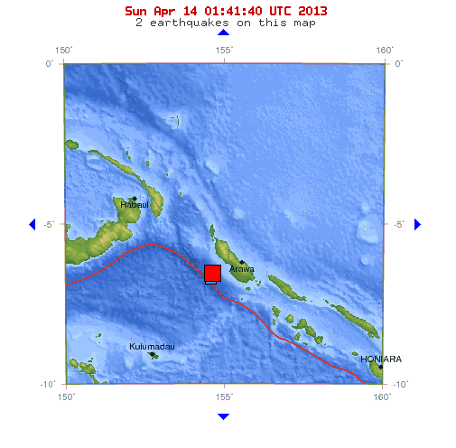
    The Earthquake/Seismic Activity Log - Page 39 Png-april-13
    6.6 magnitude earthquake strikes Bougainville region of Papua, NG
    April 14, 2013 – PAPUA, NG – An earthquake of 6.7 magnitude struck 46 miles west of Bougainville in Papua New Guinea on Sunday, the U.S. Geological Survey said. There were no immediate reports of tsunami warnings or damage. The quake was downgraded to a 6.6 by the USGS, and struck at a depth of 64.3 km (40 miles) below the surface. –Reuters


    The Earthquake/Seismic Activity Log - Page 39 Western-japan
    Powerful earthquake jolts Japan- strongest to hit the western region in decades
    A 6.0-magnitude earthquake rattled Japan early Saturday. The quake’s epicenter was near Awaji Island in in the western Japan’s Seto inland sea, not far from Kobe and Osaka. At least 24 were injured.

    April 13, 2013 – JAPAN — A strong earthquake in western Japan rattled people awake as dawn broke Saturday, injuring at least two dozen people. The U.S. Geological Survey initially reported the quake as magnitude 6.0, but later revised its reading to magnitude 5.8. The Japan Meteorological Agency ranked the quake at 6.0, but later revised their measurement to 6.3, according to Japan Today.The quake was fairly shallow but reports of the depth were not consistent. The USGS reported a depth of 5km (3.1 miles) but the Japan Meteorological Agency registered the quake at 15km (9.3 miles) deep. At least 24 people were injured and there was some damage to residential property. No fatalities were reported and there was no threat of tsunami. The quake’s epicenter was near Awaji Island in in the western Japan’s Seto inland sea, not far from Kobe and Osaka. On Earthquake-Report.com people posted reports of swaying buildings and shaking that lasted up to one minute. Reuters reported the Ikata nuclear power station near the epicenter was not affected. Separate reports indicate no damage to the country’s other nearby reactors. Among the injured were an 82-year-old woman who suffered a broken leg and a 74-year-old with a broken hip, Japan Today reported. It was one of the strongest earthquakes to strike the area in decades. A 1995 quake in Hyogo prefecture destroyed the port city of Kobe and killed 6,000. –Nature World


    _________________
    What is life?
    It is the flash of a firefly in the night, the breath of a buffalo in the wintertime. It is the little shadow which runs across the grass and loses itself in the sunset.

    With deepest respect ~ Aloha & Mahalo, Carol
    Carol
    Carol
    Admin
    Admin


    Posts : 31701
    Join date : 2010-04-07
    Location : Hawaii

    The Earthquake/Seismic Activity Log - Page 39 Empty Re: The Earthquake/Seismic Activity Log

    Post  Carol Tue Apr 16, 2013 8:47 am

    The Earthquake/Seismic Activity Log - Page 39 Quake-iran-pakistan-india.si
    7.8 magnitude earthquake strikes Iran-Pakistan border: largest quake in 40 years; hundreds feared dead
    http://online.wsj.com/article/SB10001424127887324030704578426280871179060.html
    A magnitude-7.5 earthquake hit the southeastern Iranian province of Sistan Baluchestan, near the border with Pakistan, the second powerful quake to hit Iran in less than two weeks. The quake was felt as far away as New Delhi in India, Karachi in Pakistan and Dubai on the other side of the Persian Gulf. Iran's official news agency said 20 emergency rescue teams and three helicopters have been dispatched to the area by land and air. But because the area is remote and communications have been cut, it could be some time before there are full reports of damage and casualties at the quake's epicenter. The earthquake was centered on a small town called Saravan, according to Tehran University's Geological Center. Fars News Agency said it was the largest earthquake to hit the region in at least 40 years. Fariborz Rashedi, the head of emergency medicine in Sistan Baluchestan, told Fars News Agency that so far he had received reports of only three casualties in the area.

    "We are expecting low casualty numbers and minimal damages because the area is thinly populated," Fars News Agency quoted Mohamad Sarvar, the deputy national relief coordinator, as saying.

    On April 9th a 6.3-magnitude earthquake hit southern Iran, near the Bushehr nuclear-power plant, killing 37 people and injuring more than 800. The nuclear reactor, which sits 55 kilometers from the center of that quake, wasn't affected, according to Iranian officials.

    A resident in the quake zone, Manouchehr Karimi, told the Associated Press by phone that "the quake period was long" and occurred "when many people were at home to take a midday nap."

    Shallow, deadly quake: An Iranian government official said on Tuesday he expected hundreds of deaths from a major earthquake that struck Iran near the border with Pakistan. “It was the biggest earthquake in Iran in 40 years and we are expecting hundreds of dead,” said the official, who spoke on condition of anonymity. According to officials in Iran, 87 deaths have been reported so far; however, that number is expected to rise. –Reuters, Emirates 14/7


    _________________
    What is life?
    It is the flash of a firefly in the night, the breath of a buffalo in the wintertime. It is the little shadow which runs across the grass and loses itself in the sunset.

    With deepest respect ~ Aloha & Mahalo, Carol
    Carol
    Carol
    Admin
    Admin


    Posts : 31701
    Join date : 2010-04-07
    Location : Hawaii

    The Earthquake/Seismic Activity Log - Page 39 Empty Re: The Earthquake/Seismic Activity Log

    Post  Carol Wed Apr 17, 2013 9:55 am

    The Earthquake/Seismic Activity Log - Page 39 Japan-april-17
    Japan’s volcanic island rocked by dozens of earthquakes
    April 17, 2013 – JAPAN – More than a dozen earthquakes, one of them magnitude 6.2, rocked a volcanic island south of Tokyo Wednesday, the national meteorological agency said. There were no immediate reports of injuries or property damage from any of the quakes and no risk of a tsunami, the agency said. The biggest tremor, with its epicenter located near Miyake Island some 180 kilometers (110 miles) south of Tokyo, was registered at around 5:57 pm (0857 GMT), the Japan Meteorological Agency said. “There may be slight changes in the level of sea along Japan’s coast but there is no fear of damage resulting from this quake,” the agency said. There had been 13 minor quakes near the island – an active volcano – since 10:15 am (0115 GMT) Wednesday. A small earthquake was also registered four minutes after the 6.2-magnitude tremor, the agency said. The volcano erupted in 2000, forcing all 3,800 islanders to evacuate. Many of them have since returned to the island. –ASIA ONE


    Last edited by Carol on Wed Apr 17, 2013 9:59 am; edited 1 time in total


    _________________
    What is life?
    It is the flash of a firefly in the night, the breath of a buffalo in the wintertime. It is the little shadow which runs across the grass and loses itself in the sunset.

    With deepest respect ~ Aloha & Mahalo, Carol
    Carol
    Carol
    Admin
    Admin


    Posts : 31701
    Join date : 2010-04-07
    Location : Hawaii

    The Earthquake/Seismic Activity Log - Page 39 Empty Re: The Earthquake/Seismic Activity Log

    Post  Carol Wed Apr 17, 2013 9:58 am

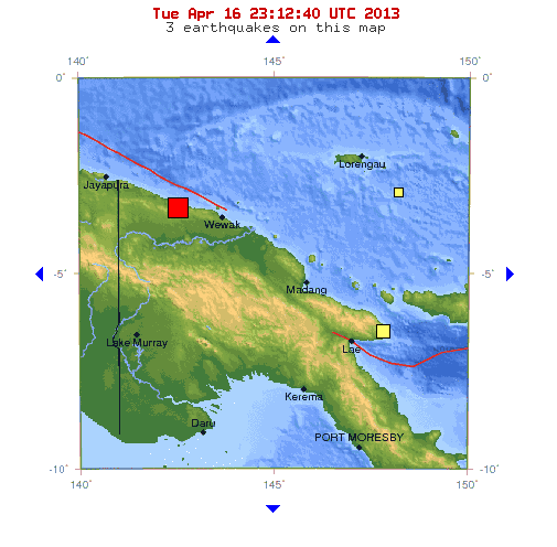
    The Earthquake/Seismic Activity Log - Page 39 Papua-ng-april-16
    Shallow 6.8 magnitude earthquake strikes northern coast of Papua New Guinea
    April 16, 2013 – PAPUA, NG – A strong earthquake with a preliminary magnitude of 6.8 was recorded off the remote northern coast of Papua New Guinea at a depth of about 8 km (5 miles) on Wednesday, the U.S. Geological Survey said. The Pacific Tsunami Warning Center in Hawaii said in a statement there was no threat of a widespread tsunami from the quake, although it warned that earthquakes of that size could generate destructive tsunamis within 100 km (60 miles) of the epicenter. The Australian government’s Bureau of Meteorology said there was no tsunami threat to Australia. There were no immediate reports of damage or injury. In 1998, part of the northern coast of Papua New Guinea was devastated by a tsunami, generated by a 7.0 quake, that killed around 2,200 people. –Yahoo News


    The Earthquake/Seismic Activity Log - Page 39 Earthquake-oklahoma
    5 earthquakes rattle Central Oklahoma
    April 16, 2013 – OKLAHOMA – Five earthquakes shook central Oklahoma early Tuesday, with the highest 4.3 magnitude quake hitting at 1:56 a.m., Central time. The temblors began at around 1:45 a.m. near the city of Chandler, Okla., which is about 30 miles northeast of Oklahoma City, the US Geological Survey reports. An official answering the dispatch line for the Oklahoma County Sheriff’s office told the Associated Press that they have received no reports of damage or injuries. Jana Pursley, a USGS geophysicist, told the Associated Press that all the quakes were shallow, measuring about three miles deep, which is common for the area. She added that it is common for several earthquakes to occur during a short period of time. The most recent quake occurred at 5:16 a.m. near Luther, Okla., at a magnitude of 4.2. The quakes were felt in Oklahoma City, where the Oklahoma Zoo tweeted, “that was certainly wild.” “At this point, it looks like a main shock, aftershock sequence. There are even a bunch of smaller ones,” Austin Holland, a geophysicist at the Oklahoma Geological Survey in Norman, told the Oklahoman in Oklahoma City. He is collecting data from Tuesday’s quakes to see if there were more than five. The Oklahoma Red Cross tweeted that they “are not anticipating damage” from the earthquakes. And although earthquakes east of the Colorado Rockies are infrequent, the Red Cross advises people to know how to react during an earthquake event. Their recommended action: Drop, cover, and hold on. It’s a message that is part of a larger regional campaign, ShakeOut, which the Red Cross has been advertising in several central US states including Alabama, Arkansas, Georgia, Kentucky, Illinois, Indiana, Mississippi, Missouri, South Carolina, and Tennessee. “Oklahoma is not immune to earthquakes,” the Red Cross said in a statement in January. The strongest earthquake in Oklahoma happened in November 2011, a 5.6 magnitude earthquake during which 2 people were injured and 14 homes were destroyed. The Oklahoma earthquakes are small compared to the 7.8 magnitude earthquake that occurred near the Iran-Pakistan border at 3:15 local time Tuesday. Iran declared a state of emergency and dozens of people are feared dead. This is the second earthquake within a week that has caused severe damage in southern Iran. –CS Monitor


    _________________
    What is life?
    It is the flash of a firefly in the night, the breath of a buffalo in the wintertime. It is the little shadow which runs across the grass and loses itself in the sunset.

    With deepest respect ~ Aloha & Mahalo, Carol
    Carol
    Carol
    Admin
    Admin


    Posts : 31701
    Join date : 2010-04-07
    Location : Hawaii

    The Earthquake/Seismic Activity Log - Page 39 Empty Re: The Earthquake/Seismic Activity Log

    Post  Carol Fri Apr 19, 2013 9:04 am

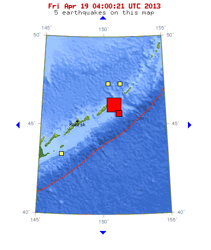
    The Earthquake/Seismic Activity Log - Page 39 Kuril-april-18
    7.2 magnitude earthquake strikes Kuril Islands
    April 19, 2013 – KURIL ISLANDS – A large earthquake, initially reported as 7.2, has been recorded in the islands north of Japan. The USGS report placed the quake at a depth of 10km in the Kuril Islands, 258km east-north-east of the Kuril Islands. The initial report of 7.0 has since been revised upwards to 7.2. The quake was felt in Hokkaido and much of the northern island of Japan. It was also reportedly felt in Tokyo. “We have received no reports of damage so far,” a spokesman at the Hokkaido police said, adding there were no reports of injuries. No reports of a tsunami have yet been made. The Tsunami Information centre in the Hawaiian Islands reports that; based on past history of earthquakes in that area, a major tsunami is not likely. –The Australian


    _________________
    What is life?
    It is the flash of a firefly in the night, the breath of a buffalo in the wintertime. It is the little shadow which runs across the grass and loses itself in the sunset.

    With deepest respect ~ Aloha & Mahalo, Carol
    Carol
    Carol
    Admin
    Admin


    Posts : 31701
    Join date : 2010-04-07
    Location : Hawaii

    The Earthquake/Seismic Activity Log - Page 39 Empty Re: The Earthquake/Seismic Activity Log

    Post  Carol Fri Apr 19, 2013 12:39 pm

    The Earthquake/Seismic Activity Log - Page 39 800px-MiyakeFromKozuTyoJpDec04-01
    Earthquake swarm continues under Miyake volcano at Japan’s Izu Islands
    April 19, 2013 – JAPAN - A strong earthquake swarm, presumably caused by a magmatic intrusion, has started Wednesday at Miyake volcano in the Japanese Izu Islands. On Wednesday alone, JMA recorded 136 earthquakes with magnitudes up to an earthquake of magnitude 5.6, which was widely felt in the region. The quakes’ hypocenters are clustered in a NNW-SSW trending area about 10 km west of the island, at depths of 5-15 km. The volcano last erupted in 2010. –Volcano Discovery


    _________________
    What is life?
    It is the flash of a firefly in the night, the breath of a buffalo in the wintertime. It is the little shadow which runs across the grass and loses itself in the sunset.

    With deepest respect ~ Aloha & Mahalo, Carol
    Carol
    Carol
    Admin
    Admin


    Posts : 31701
    Join date : 2010-04-07
    Location : Hawaii

    The Earthquake/Seismic Activity Log - Page 39 Empty Re: The Earthquake/Seismic Activity Log

    Post  Carol Fri Apr 19, 2013 11:12 pm

    The biggest earthquakes make the Earth ring like a bell. But do earthquakes that rock the world increase the risk of new temblors? Not by much, according to two reports presented today (April 19) at the Seismological Society of America's annual meeting in Salt Lake City. In fact, one recent quake near Sumatra, Indonesia, seemed to actually quiet global earthquakes.

    The April 11, 2012, Indian Ocean earthquake was the largest strike-slip shake-up ever recorded. A strike-slip fault moves horizontally, as California's San Andreas Fault does. The magnitude-8.6 quake triggered earthquakes worldwidefor up to six days, said Fred Pollitz, a geophysicist at the U.S. Geological Survey's (USGS) Menlo Park, Calif., office. But once the triggered quakes stopped, Pollitz was surprised to find a sharp drop in moderate earthquakes for more than three months. Seismic monitors detected no earthquakes bigger than magnitude 6.5 for 95 days. Normally, quakes of this size hit every 10 days, Pollitz said.

    "That is quite a rare occurrence," he told OurAmazingPlanet. "The chance of that happening is about 1 in 10,000."

    Energetic earthquake

    Pollitz thinks the Indian Ocean earthquake's unusually energetic seismic waves, which traveled shallowly through Earth's crust for long distances, could have shifted stresses on faraway faults, delaying earthquakes.

    "Usually, these dynamic seismic waves only increase the chance of an earthquake at any distance," Pollitz said. "We've documented, for the first time, that they can also decrease the chance of an earthquake."

    Because it doesn't necessarily take a massive earthquake to trigger new shocks — the 2002 Denali, Alaska, earthquake, a magnitude 7.9, set off quakes throughout the northwestern United States — Pollitz wants to comb through past earthquake records in hopes of finding more quiet periods.

    "We need to go back and look at these other earthquakes and see if this is a general pattern of a temporary increase and a longer-term decrease," Pollitz said.

    Global risk

    Although the Indian Ocean earthquake may have had a rare calming effect after some time had passed, it did immediately spark a global furry of quakes, as many massive earthquakes often do. Tom Parsons, a USGS geophysicist also at Menlo Park, wants to know how often dangerously large temblors follow strong earthquakes. [Stunning Map Reveals World's Earthquakes Since 1898]

    "Every time we have a magnitude 7 or something larger, should the whole rest of the planet be concerned about the increase in hazard?" Parsons told OurAmazingPlanet.

    Parsons analyzed hundreds of earthquakes of at least magnitude 7.0 in the past 30 years. Only 24 of the 260 big earthquakes triggered large earthquakes globally.


    _________________
    What is life?
    It is the flash of a firefly in the night, the breath of a buffalo in the wintertime. It is the little shadow which runs across the grass and loses itself in the sunset.

    With deepest respect ~ Aloha & Mahalo, Carol
    Carol
    Carol
    Admin
    Admin


    Posts : 31701
    Join date : 2010-04-07
    Location : Hawaii

    The Earthquake/Seismic Activity Log - Page 39 Empty Re: The Earthquake/Seismic Activity Log
    Post  Carol Fri Apr 19, 2013 11:15 pm

    At least 28 people killed, hundreds injured in 6.6 magnitude quake in southwestern province, state media reports. At least 28 people have been killed in a 6.6 magnitude earthquake which struck the southwestern Chinese province of Sichuan, the official China News Service reported. The quake hit just after 8am (0000 GMT) on Saturday and was felt in the provincial capital of Chengdu 110 kilometres to the east, the state news agency Xinhua reported. Sichuan, like neighbouring areas, is prone to such tremors and saw one of the country's worst quakes in decades in 2008 that left 87,000 people missing or dead. Xinhua put the quake at magnitude 7.0 with a depth of 13 kilometres, citing the China Earthquake Networks Centre, while the USGS downgraded the quake from an earlier reading of 6.9. Earthquakes frequently strike the country's southwest, with twin tremors in neighbouring Yunnan province last September triggering landslides that left at least 80 people dead.


    _________________
    What is life?
    It is the flash of a firefly in the night, the breath of a buffalo in the wintertime. It is the little shadow which runs across the grass and loses itself in the sunset.

    With deepest respect ~ Aloha & Mahalo, Carol
    Carol
    Carol
    Admin
    Admin


    Posts : 31701
    Join date : 2010-04-07
    Location : Hawaii

    The Earthquake/Seismic Activity Log - Page 39 Empty Re: The Earthquake/Seismic Activity Log
    Post  Carol Fri Apr 19, 2013 11:18 pm

    Thousands of people remain in urgent need of aid after devastating earthquake in neighbouring Iran. More than 12,000 people are believed to have lost their homes following Tuesday's massive earthquake in neighbouring Iran. Most people in Mashkel live in poverty and the earthquake took all they had. Residents told Al Jazeera that though the Pakistani authorities have delivered aid, many were still desperate for help. Al Jazeera's Osama Bin Javaid reports.


    _________________
    What is life?
    It is the flash of a firefly in the night, the breath of a buffalo in the wintertime. It is the little shadow which runs across the grass and loses itself in the sunset.

    With deepest respect ~ Aloha & Mahalo, Carol

      Current date/time is Fri Apr 26, 2024 4:10 pm