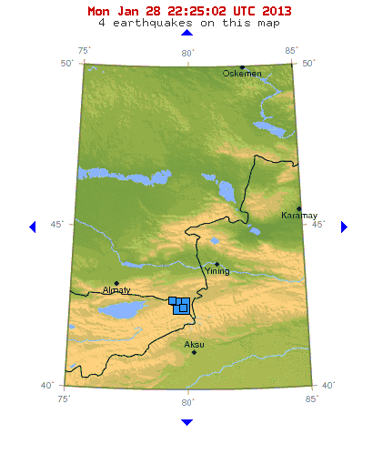
4.6 magnitude earthquake strikes Sicily
+21
Aquaries1111
giovonni
arvan33
Floyd
lawlessline
JesterTerrestrial
THEeXchanger
newel
Brook
greybeard
Mercuriel
Sanicle
devakas
hobbit
mudra
burgundia
lindabaker
LeeEllisMusic
MargueriteBee
Carol
HigherLove
25 posters
The Earthquake/Seismic Activity Log
Carol- Admin
- Posts : 31733
Join date : 2010-04-07
Location : Hawaii
- Post n°926
Re: The Earthquake/Seismic Activity Log
4.6 magnitude earthquake strikes Sicily
_________________
What is life?
It is the flash of a firefly in the night, the breath of a buffalo in the wintertime. It is the little shadow which runs across the grass and loses itself in the sunset.
With deepest respect ~ Aloha & Mahalo, Carol
Carol- Admin
- Posts : 31733
Join date : 2010-04-07
Location : Hawaii
- Post n°927
Re: The Earthquake/Seismic Activity Log
First Report: The U.S. Geological Survey says the magnitude 7.6 quake struck at midnight Friday Alaska time and was centered about 60 miles (95 kilometers) west of Craig, Alaska.
Strong 7.5 Earthquake Shakes Parts of Alaska, Canada
JUNEAU, Alaska January 5, 2013 (AP) -A powerful earthquake sparked a tsunami warning for hundreds of miles of Alaskan and Canadian coastline, but the alert was canceled when no damaging waves were generated.
The magnitude 7.5 quake and tsunami warning that followed caused concern in some coastal communities, with alarms sounding and people rushing to higher ground for safety.
But the Alaska Tsunami Warning Center later said the waves were too small to pose a threat, reaching just six inches above normal sea level in places such as Sitka and Port Alexander.
"Initially, in the first 15 to 20 minutes, there might have been a bit of panic," Sitka Police Chief Sheldon Schmitt told The Associated Press in a phone interview. But he said things calmed down as the town waited for the all clear.
The temblor struck at midnight Friday (1 a.m. PST Saturday) and was centered about 60 miles west of Craig, Alaska, the U.S. Geological Survey said.
Seismologist Jana Pursley of the USGS said the quake was followed by six aftershocks, the strongest of which registered a 5.1 and came nearly four hours after the initial quake.
"Houses shook; mine had things tossed from (the) wall," Craig Police Chief Robert Ely said. But he added that there were "no reports of any injuries, no wave, no tidal movement seen."
The tsunami warning was eventually expanded to include coastal areas from Cape Fairweather, Alaska, to the northern tip of Vancouver Island, Canada — an area extending more than 700 miles.
The center had warned that "significant widespread inundation of land is expected," adding that dangerous coastal flooding was possible.
In its cancellation statement, the center said that some areas were seeing just small sea level changes.
"A tsunami was generated during this event but no longer poses a threat," the center said.
The Alaska Earthquake Information Center said the quake was widely felt but it received no reports of any damage.
"It was the most intense earthquake I've felt in my 10 years here. I'm pretty sure there was stuff falling off of shelves," Chief Schmitt said. "There is no report of any wave activity here."
He said that an evacuation sirens and announcements came shortly after the quake, prompting the temporary rush to higher ground.
Some people in Craig also moved to safer territory.
"Several citizens elected on their own to move to higher ground. Several locations in Craig were set up for staging (and) shelter," said Chief Ely, adding that "no evacuation was ordered."
In addition to the warning, a tsunami advisory was briefly in effect for some Alaska coastal areas to the north of the warning zone, as well as to the south of the zone, from the Washington state border to the northern tip of Vancouver Island.
A tsunami warning means an area is likely to be hit by a wave, while an advisory means there may be strong currents, but that widespread inundation is not expected to occur.
http://quakes.globalincidentmap.com
Saturday January 5 2013, 08:58:24 UTC 6 hours ago Southeastern Alaska. 7.8 28.0 GeoScience Australia Detail
Saturday January 5 2013, 08:58:19 UTC 6 hours ago Southeastern Alaska 7.5 10.0 CSEM-EMSC Feed Detail
Saturday January 5 2013, 08:58:19 UTC 6 hours ago Southeastern Alaska. 7.8 10.0 GeoScience Australia Detail
Saturday January 5 2013, 08:58:19 UTC 6 hours ago Southeastern Alaska 7.5 9.8 USGS Feed Detail
Saturday January 5 2013, 08:58:16 UTC 6 hours ago Southeastern Alaska 7.7 5.0 USGS Feed Detail
_________________
What is life?
It is the flash of a firefly in the night, the breath of a buffalo in the wintertime. It is the little shadow which runs across the grass and loses itself in the sunset.
With deepest respect ~ Aloha & Mahalo, Carol
lawlessline- Posts : 699
Join date : 2010-04-23
Age : 51
- Post n°928
Re: The Earthquake/Seismic Activity Log
Heres a great site if you want to check through data of past EQs.
http://www.ga.gov.au/earthquakes/searchQuake.do
If anyone needs.
t
http://www.ga.gov.au/earthquakes/searchQuake.do
If anyone needs.
t
Carol- Admin
- Posts : 31733
Join date : 2010-04-07
Location : Hawaii
- Post n°929
Re: The Earthquake/Seismic Activity Log
_________________
What is life?
It is the flash of a firefly in the night, the breath of a buffalo in the wintertime. It is the little shadow which runs across the grass and loses itself in the sunset.
With deepest respect ~ Aloha & Mahalo, Carol
Carol- Admin
- Posts : 31733
Join date : 2010-04-07
Location : Hawaii
- Post n°930
Re: The Earthquake/Seismic Activity Log
Scientists seek foolproof way to predict earthquakes using magnetic waves
http://news.nationalgeographic.com/news/2013/01/04-earthquakees-defy-prediction-efforts/
January 6, 2013 – CALIFORNIA – Twenty-three hundred years ago, hordes of mice, snakes, and insects fled the Greek city of Helike on the Gulf of Corinth (map). “After these creatures departed, an earthquake occurred in the night,” wrote the ancient Roman writer Claudius Aelianus. “The city subsided; an immense wave flooded and Helike disappeared.” Since then, generations of scientists and folklorists have used a dizzying array of methods to attempt to predict earthquakes. Animal behavior, changes in the weather and seismograms have all fallen short. One theory is that when an earthquake looms, the rock “goes through a strange change,” producing intense electrical currents, says Tom Bleier, a satellite engineer with QuakeFinder, a project funded by his parent company, Stellar Solutions, of Cambridge, Massachusetts. “These currents are huge,” Bleier said at the AGU meeting. “They’re on the order of 100,000 amperes for a magnitude 6 earthquake and a million amperes for a magnitude 7. It’s almost like lightning, underground.” To measure those currents, Bleier’s team has spent millions of dollars putting out magnetometers along fault lines in California, Peru, Taiwan, and Greece. The instruments are sensitive enough to detect magnetic pulses from electrical discharges up to 10 miles (16 kilometers) away. “In a typical day along the San Andreas fault (in California), you might see ten pulses per day,” he told National Geographic News. “The fault is always moving, grinding, snapping, and crackling.” Before a large earthquake, that background level of static-electricity discharges should rise sharply, Bleier said. And that is indeed what he claims he’s seen prior to the half dozen magnitude 5 and 6 earthquakes whose precursors he’s been able to monitor. “It goes up to maybe 150 or 200 pulses a day,” he said. The number of pulses, he added, seems to surge about two weeks before the earthquake then drop back to background level until shortly before the fault slips. “That’s the pattern we’re looking for,” he said. –NGhttp://news.nationalgeographic.com/news/2013/01/04-earthquakees-defy-prediction-efforts/
_________________
What is life?
It is the flash of a firefly in the night, the breath of a buffalo in the wintertime. It is the little shadow which runs across the grass and loses itself in the sunset.
With deepest respect ~ Aloha & Mahalo, Carol
Carol- Admin
- Posts : 31733
Join date : 2010-04-07
Location : Hawaii
- Post n°931
Re: The Earthquake/Seismic Activity Log
5.7 magnitude earthquake in Aegean Sea rattles cities in Turkey and Greece
_________________
What is life?
It is the flash of a firefly in the night, the breath of a buffalo in the wintertime. It is the little shadow which runs across the grass and loses itself in the sunset.
With deepest respect ~ Aloha & Mahalo, Carol
Carol- Admin
- Posts : 31733
Join date : 2010-04-07
Location : Hawaii
- Post n°932
Re: The Earthquake/Seismic Activity Log
Earthquake swarm rattles seafloor along Carlsberg Ridge
The Carlsberg Ridge is the northern section of the Central Indian Ridge, a divergent tectonic plate boundary between the African Plate and the Indo-Australian Plate, traversing the western regions of the Indian Ocean. The ridge of which the Carlsberg Ridge is a part extends northward from a triple point junction near the island of Rodrigues (the Rodrigues Triple Point) to a junction with the Owen Fracture Zone. The ridge started its northwards propagation in the late Maastrichtian and reached the incipient Arabian Sea in the Eocene. Then it continued to accrete basalt but did not propagate for nearly 30 Ma. Then, in the early Miocene it started to propagate westwards towards the Afar hot spot, opening the Gulf of Aden. The Carlsberg Ridge is seismically active, with a major earthquake being recorded by the U.S. Geological Survey at 7.6 on the moment magnitude scale on July 15, 2003. –Wikipedia
_________________
What is life?
It is the flash of a firefly in the night, the breath of a buffalo in the wintertime. It is the little shadow which runs across the grass and loses itself in the sunset.
With deepest respect ~ Aloha & Mahalo, Carol
Carol- Admin
- Posts : 31733
Join date : 2010-04-07
Location : Hawaii
- Post n°933
Re: The Earthquake/Seismic Activity Log
5.5 magnitude earthquake strikes Gulf of California
_________________
What is life?
It is the flash of a firefly in the night, the breath of a buffalo in the wintertime. It is the little shadow which runs across the grass and loses itself in the sunset.
With deepest respect ~ Aloha & Mahalo, Carol
Carol- Admin
- Posts : 31733
Join date : 2010-04-07
Location : Hawaii
- Post n°934
Re: The Earthquake/Seismic Activity Log
Earthquake shakes up residents in Tasmania
Seismologist warns tremors signal larger quakes: Smaller earthquakes in Cowra and surrounds could be a warning for stronger, potentially damaging earthquakes, says a prominent seismologist. Director at the Australian Seismological Centre in Canberra Kevin McCue said a 3.2 magnitude earthquake on Monday night at Frogmore could be a sign of things to come. “This morning a small, shallow, magnitude 3.2 earthquake was recorded on the network at 12 minutes past 3am,” he said. “It was big enough to be quite strongly felt if you were within 10km of the epicenter.” Mr. McCue said that a series of smaller earthquakes could potentially lead to a larger, more serious earthquake with a magnitude 5 or higher. He said earthquakes are often overlooked because damaging events are rare compared to other natural disasters. “We cannot predict earthquakes, but there is a 10 per cent chance of [a one in] 500 year earthquake occurring in any 50 years, the next 50; or similarly that the 100 years earthquake has a 10 per cent chance of occurring in the next 10 years.” Cowra was shaken last year with a magnitude 3.8 with an epicenter 10km north of Boorowa. “I just want to make sure people know these are still happening.” Earthquakes occur when rocks break and move as a result of stresses caused by tectonic plates. However, earthquakes are rare in Australia as it is located in the middle of the Indo-Australian tectonic plate, with no major fault lines running through the country. But Mr McCue said that even though the nearest fault line to the region runs through New Zealand and other island nations in the Pacific Ocean, there are minor fault lines running through Australia. “There are [minor] faults everywhere in Australia,” he said. “Because our continent is so old, there has been plenty of time for these faults to occur.” He said these minor fault lines are caused when the Indo Australian plate rubs alongside the Pacific plate. –CG
_________________
What is life?
It is the flash of a firefly in the night, the breath of a buffalo in the wintertime. It is the little shadow which runs across the grass and loses itself in the sunset.
With deepest respect ~ Aloha & Mahalo, Carol
Carol- Admin
- Posts : 31733
Join date : 2010-04-07
Location : Hawaii
- Post n°935
Re: The Earthquake/Seismic Activity Log
Shallow 4.1 magnitude earthquake rattles East Texas
Earthquake swarm reported near Nevada’s Topaz Lake
Oregon quake cluster: A small cluster of modest earthquakes has been recorded off the central Oregon coast with the largest a magnitude 3.4. A handful of people reported feeling the 3.4 quake that hit shortly before 8 p.m. Thursday. The quakes had an average depth of about 35 km (22 miles). Geophysicist Randy Baldwin of the U.S. Geological Survey’s National Earthquake Information Center in Golden, Colo., says small quakes in that area would not be expected to cause any damage on land. The quakes were centered about 30 miles west of Waldport. Others included a magnitude 3.0 and a 2.6. Baldwin says such quakes are fairly common. –Oregon Live
_________________
What is life?
It is the flash of a firefly in the night, the breath of a buffalo in the wintertime. It is the little shadow which runs across the grass and loses itself in the sunset.
With deepest respect ~ Aloha & Mahalo, Carol
Carol- Admin
- Posts : 31733
Join date : 2010-04-07
Location : Hawaii
- Post n°936
Re: The Earthquake/Seismic Activity Log
6.0 magnitude earthquake shakes buildings in Eastern Kazakhstan
5 moderate earthquakes strike in Earth’s southern polar region
Guam earthquake goes unreported: An earthquake that shook the island just before 8am Monday morning has not been reported by the U.S. Geological Survey. The earthquake gently shook buildings throughout the island, but caused no reported damage or injuries. The magnitude of the earthquake is unclear because the USGS website, which normally records and reports earthquakes throughout the world, did not report this temblor. It’s not clear why the earthquake was unreported, but it’s not the first time. Last year, a similarly mild earthquake went unreported by the USGS. Email inquires to the Western Regional Office of the USGS have not been answered. -PNC
California to get early-warning quake system: Californians would have precious seconds to prepare for a major earthquake under a new proposal to create a statewide early warning system. State Sen. Alex Padilla joined with seismologists Monday in announcing legislation to create the system. The U.S. has been testing warning systems for several years but lags behind countries such as Japan and Mexico in implementing the technology to warn the public. Such systems are designed to detect the first pulses of energy from an earthquake, estimate its magnitude and send alerts before damaging seismic waves spread widely. Warning times would range from a few seconds to tens of seconds—enough time for people to take cover or begin shutting down systems that could be damaged by severe shaking. –Mercury
_________________
What is life?
It is the flash of a firefly in the night, the breath of a buffalo in the wintertime. It is the little shadow which runs across the grass and loses itself in the sunset.
With deepest respect ~ Aloha & Mahalo, Carol
Carol- Admin
- Posts : 31733
Join date : 2010-04-07
Location : Hawaii
- Post n°937
Re: The Earthquake/Seismic Activity Log
Magnitude-6.8 Earthquake Shakes Northern Chile
ABC News - 52 minutes ago
A magnitude-6.8 earthquake shook buildings and broke some windows in north-central Chile on Wednesday, but officials discounted the possibility of a tsunami and reported no major damages.
_________________
What is life?
It is the flash of a firefly in the night, the breath of a buffalo in the wintertime. It is the little shadow which runs across the grass and loses itself in the sunset.
With deepest respect ~ Aloha & Mahalo, Carol
Carol- Admin
- Posts : 31733
Join date : 2010-04-07
Location : Hawaii
- Post n°938
Re: The Earthquake/Seismic Activity Log
Four strong earthquakes signal angry ‘Ring of Fire’
6.0 magnitude earthquake shakes southeastern Alaska
January 31, 2013 – ANCHORAGE, Alaska —A strong shallow earthquake has shaken southeastern Alaska, but officials say there is no danger of a tsunami and there are no immediate reports of any damage. The U.S. Geological Survey said the 6.0 magnitude quake struck about 1 a.m. Thursday and was centered in the ocean, about 188 miles south of the capital, Juneau. The Tsunami Warning Center says there is no danger of a tsunami. The earthquake was widely felt across the region, according to the Alaska Earthquake Information Center. However, it had no immediate reports of any damage. The center believes the quake is an aftershock to a magnitude 7.5 temblor that struck the region on January 4. That earthquake sparked a tsunami warning for hundreds of miles along the Alaska and Canadian coasts, but it was cancelled after a few hours when no damaging waves were generated. The 6.0 quake in Alaska is the fourth strong earthquake to rumble across the planet in 24 hours, following events in the Santa Cruz Islands and Chile. Seismic tension across the planet remains relatively elevated. –The Extinction Protocol
6.2 magnitude earthquake strikes region of Santa Cruz Islands
January 31, 2013 – SANTA CRUZ ISLANDS – A deep 6.2 magnitude earthquake struck near the Santa Cruz Islands in the Pacific, about four hours after the region was rattled by a 6.0 magnitude earthquake. The 6.2 magnitude earthquake had a depth of 55.4 km (34.4 miles) with an epicenter of 60 km (37 miles) E of Lata, Solomon Islands. This is the third major earthquake to strike the planet in a 24 hour period. The planet is experiencing a heightened level of seismic activity following a record number of volcanoes across the globe exhibiting activity in the month of January. Today’s earthquake was followed in rapid succession by two 5.6 aftershocks, and a 5.0 magnitude earthquake in southern Sumatra, Indonesia, and a 4.5 aftershock in Atacama, Chile from the 6.8 magnitude earthquake. Seismic tension is also mounting on the Indo-Australian and Sunda plate near the region of Indonesia. –The Extinction Protocol
_________________
What is life?
It is the flash of a firefly in the night, the breath of a buffalo in the wintertime. It is the little shadow which runs across the grass and loses itself in the sunset.
With deepest respect ~ Aloha & Mahalo, Carol
Carol- Admin
- Posts : 31733
Join date : 2010-04-07
Location : Hawaii
- Post n°939
Re: The Earthquake/Seismic Activity Log
6.9 HOKKAIDO, JAPAN REGION
This event has been reviewed by a seismologist.
Magnitude 6.9
Date-Time Saturday, February 02, 2013 at 14:17:34 UTC
Saturday, February 02, 2013 at 11:17:34 PM at epicenter
Location 42.812°N, 143.078°E
Depth 103.1 km (64.1 miles)
Region HOKKAIDO, JAPAN REGION
Distances 109 km (68 miles) W (261°) from Kushiro, Hokkaido, Japan
120 km (75 miles) SSE (152°) from Asahikawa, Hokkaido, Japan
144 km (89 miles) ESE (102°) from Sapporo, Hokkaido, Japan
844 km (525 miles) NNE (19°) from TOKYO, Japan
Location Uncertainty horizontal +/- 14.6 km (9.1 miles); depth +/- 8.9 km (5.5 miles)
http://earthquake.usgs.gov/earthquakes/recenteqsww/Quakes/usc000f03a.php
_________________
What is life?
It is the flash of a firefly in the night, the breath of a buffalo in the wintertime. It is the little shadow which runs across the grass and loses itself in the sunset.
With deepest respect ~ Aloha & Mahalo, Carol
Carol- Admin
- Posts : 31733
Join date : 2010-04-07
Location : Hawaii
- Post n°940
Re: The Earthquake/Seismic Activity Log
Austria shaken by strongest earthquake in 13 years
February 2, 2013 – AUSTRIA – A 4.5-magnitude quake shook southern Austria on Saturday, the country’s ZAMG meteorological and geodynamic institute said, but it was not immediately clear whether it had caused any damage. The quake struck at 14:35 pm (1335 GMT) and “was strongly felt” in the Karavanke mountain range bordering Slovenia, near Eisenkappel in Austria’s southern state of Carinthia, the centre said.
Earth reeling from nine major earthquakes, striking in 5 days
February 2, 2013 – EARTH – An earthquake of magnitude 6.7 struck off the coast of the Solomon Islands (Santa Cruz) in the Pacific Ocean, the U.S. Geological Survey said on Friday. The quake was later downgraded by the USGS to a 6.3 magnitude event. The depth of the quake was 10 km (6.2 miles) and the epicenter was 68 km southwest of Lata. The quake hit at 9:16 a.m. local time on Saturday. The Pacific Tsunami Warning Center did not immediately issue any alerts on its website. This quake was underscored by an even stronger 6.9 magnitude earthquake that just struck the Hokkaido region of East Japan on February 2nd. This is the ninth major earthquake to strike the planet in the last five days. The present cluster of earthquakes began with a 6.0 event in Eastern Kazakhstan on January 28th, following a full moon on January 27, 2013. Perhaps, it may not be readily apparent to most that our planet appears to now be inching towards the spectrum of some major cataclysmic event. This approaching black swan occurrence is characterized by the gradual escalation of geological activity of a violent seismic and volcanic nature. 44 volcanic eruptive events have already been recorded for the month of January; where there was only 77 chronicled for the entire year of 2012.
The on-going volcanic activity in Kamchatka also provides compelling testament that massive changes are now taking place within the planet’s interior. No less than 4 volcanoes on the Far Eastern peninsula of Kamchatka are erupting simultaneous, though all the volcanoes lie in relative close proximity to each other (with a 110 km radius). Even more interesting, the magma flow fueling each volcanic system appears to emanting from a separate magma source. However, what’s even more disconcerting is the fact that Plosky Tolbachik volcano awakened from 40 years of dormancy and is now ejecting massive rivers of lava across the landscape of Kamchatka. Russian scientists attest this is the first time rivers of lava have ever flowed from one of the Kamchatka volcanoes during the Holocene period. Large-scale protracted effusive eruptions, such as these, are generally fueled by a deep magma source.
_________________
What is life?
It is the flash of a firefly in the night, the breath of a buffalo in the wintertime. It is the little shadow which runs across the grass and loses itself in the sunset.
With deepest respect ~ Aloha & Mahalo, Carol
Carol- Admin
- Posts : 31733
Join date : 2010-04-07
Location : Hawaii
- Post n°941
Re: The Earthquake/Seismic Activity Log
8.0 SANTA CRUZ ISLANDS
Tsunami Warning Issued for South Pacific Islands -SYDNEY February 6, 2013 (AP)
It wasn't yet known if a tsunami was generated. The Pacific Tsunami Warning Center says it issued a warning based on an evaluation of the earthquake.
The U.S. Geological Survey says the 8.0-magnitude quake struck Wednesday 81 kilometers (50 miles) west of Lata, in the Solomon Islands, at a depth of 5.8 kilometers (3.6 miles.)
Josephine Mae, a police official in the Solomon's capital city of Honiara, said she had not felt any shaking.
The Pacific Tsunami Warning Center says the tsunami warning is in effect for the Solomon Islands, Vanuatu, Nauru, Papua New Guinea, Tuvalu, New Caledonia, Kosrae, Fiji, Kiribati, Wallis and Futuna. A tsunami watch is in effect for American Samoa, Australia, New Zealand and eastern Indonesia.
February 5, 2013 – SOLOMON ISLANDS - An earthquake measuring 8.0 magnitude struck southeast of the Solomon Islands on Wednesday, the U.S. Geological Survey reported. ABC News.net reports three villages were wiped out on the Santa Cruz Islands. The earthquake struck at the fairly shallow depth of 28.7 km (17.8 miles), and a tsunami warning was issued for the region. This is the second largest earthquake to ever strike the Solomon Island region and the strongest to hit the region in almost 40 years. The largest earthquake to ever strike the region was an 8.1 magnitude earthquake that struck 104 km from Honiara Makira, Solomon Islands on April 21, 1977. However, today’s 8.0 magnitude earthquake was some 581 km (361 miles) ESE of Honiara, Solomon Islands and represents a new geologically-agitated tension spot. The quake was followed by two powerful aftershocks, a 6.4 and 6.6. This is now the ninth major earthquake to strike this region since January 31, 203. –The Extinction Protocol – ABC
_________________
What is life?
It is the flash of a firefly in the night, the breath of a buffalo in the wintertime. It is the little shadow which runs across the grass and loses itself in the sunset.
With deepest respect ~ Aloha & Mahalo, Carol
Carol- Admin
- Posts : 31733
Join date : 2010-04-07
Location : Hawaii
- Post n°942
Re: The Earthquake/Seismic Activity Log
7.0 COLOMBIA
http://www.emsc-csem.org/Earthquake/earthquake.php?id=304122
DATE LAT LON MAG DEPTH
km REGION
09-FEB-2013 14:16:06 1.14 -77.36 7.0 129 COLOMBIA
09-FEB-2013 12:28:57 -11.09 165.73 5.1 10 SANTA CRUZ ISLANDS
09-FEB-2013 10:23:52 -11.87 165.63 5.1 10 SANTA CRUZ ISLANDS
09-FEB-2013 08:40:04 -11.10 116.33 4.9 32 SOUTH OF SUMBAWA, INDONESIA
09-FEB-2013 08:04:05 -11.24 165.65 5.3 10 SANTA CRUZ ISLANDS
09-FEB-2013 07:34:36 -10.86 165.13 4.7 46 SANTA CRUZ ISLANDS
09-FEB-2013 06:44:23 -11.87 165.06 5.0 10 SANTA CRUZ ISLANDS
09-FEB-2013 06:42:03 -10.91 165.13 4.6 10 SANTA CRUZ ISLANDS
09-FEB-2013 05:45:01 -11.11 161.65 4.8 36 SOLOMON ISLANDS
09-FEB-2013 05:32:08 -10.92 166.00 5.6 10 SANTA CRUZ ISLANDS
09-FEB-2013 04:43:08 36.96 141.10 5.0 30 NEAR EAST COAST OF HONSHU, JAPAN
09-FEB-2013 03:01:11 -10.91 165.91 4.5 15 SANTA CRUZ ISLANDS
09-FEB-2013 02:50:38 2.34 99.17 4.7 163 NORTHERN SUMATERA, INDONESIA
09-FEB-2013 02:47:29 -11.38 165.83 4.8 15 SANTA CRUZ ISLANDS
09-FEB-2013 02:16:56 -7.03 117.15 4.6 603 BALI SEA
08-FEB-2013 23:16:30 -11.05 166.72 5.3 35 SANTA CRUZ ISLANDS
08-FEB-2013 23:15:38 -10.91 165.79 5.0 35 SANTA CRUZ ISLANDS
08-FEB-2013 22:45:12 -10.91 165.91 5.0 35 SANTA CRUZ ISLANDS
08-FEB-2013 22:30:17 -10.93 165.69 4.7 35 SANTA CRUZ ISLANDS
08-FEB-2013 22:29:44 -11.35 165.22 4.0 35 SANTA CRUZ ISLANDS
08-FEB-2013 22:25:30 -10.99 165.81 4.9 35 SANTA CRUZ ISLANDS
08-FEB-2013 21:06:11 15.01 -92.66 4.7 103 MEXICO-GUATEMALA BORDER REGION
08-FEB-2013 20:05:51 -10.96 165.90 5.2 29 SANTA CRUZ ISLANDS
08-FEB-2013 19:32:04 36.11 69.89 4.4 90 HINDU KUSH REGION, AFGHANISTAN
08-FEB-2013 19:31:47 4.44 126.19 4.7 146 TALAUD ISLANDS, INDONESIA
08-FEB-2013 19:09:11 -10.86 166.06 5.1 25 SANTA CRUZ ISLANDS
08-FEB-2013 18:10:47 -10.76 166.03 5.3 26 SANTA CRUZ ISLANDS
08-FEB-2013 18:07:53 -10.99 166.41 5.7 58 SANTA CRUZ ISLANDS
08-FEB-2013 17:59:52 -6.28 154.80 5.9 75 SOLOMON ISLANDS
08-FEB-2013 17:48:51 -6.10 148.92 5.0 72 NEW BRITAIN REGION, P.N.G.
08-FEB-2013 17:42:34 -10.95 165.47 5.1 20 SANTA CRUZ ISLANDS
08-FEB-2013 15:56:09 -11.37 165.45 4.8 10 SANTA CRUZ ISLANDS
08-FEB-2013 15:46:12 -10.72 166.13 4.8 10 SANTA CRUZ ISLANDS
08-FEB-2013 15:42:59 -10.95 166.06 4.6 10 SANTA CRUZ ISLANDS
08-FEB-2013 15:26:39 -10.91 165.96 7.0 27 SANTA CRUZ ISLANDS
08-FEB-2013 15:00:12 -10.98 165.87 5.8 10 SANTA CRUZ ISLANDS
08-FEB-2013 14:14:09 -10.96 165.88 5.2 10 SANTA CRUZ ISLANDS
08-FEB-2013 14:10:38 -11.11 165.87 5.3 10 SANTA CRUZ ISLANDS
08-FEB-2013 13:39:27 -10.91 165.88 4.8 10 SANTA CRUZ ISLANDS
08-FEB-2013 13:28:09 -10.85 166.78 4.9 10 SANTA CRUZ ISLANDS
08-FEB-2013 12:34:00 1.19 126.59 4.7 10 NORTHERN MOLUCCA SEA
08-FEB-2013 12:09:19 -10.97 165.88 5.1 10 SANTA CRUZ ISLANDS
08-FEB-2013 12:03:39 -10.90 165.96 5.0 10 SANTA CRUZ ISLANDS
08-FEB-2013 11:56:11 -10.92 165.93 5.0 10 SANTA CRUZ ISLANDS
08-FEB-2013 11:39:41 -10.95 165.90 5.1 10 SANTA CRUZ ISLANDS
08-FEB-2013 11:25:41 -11.43 165.44 4.9 10 SANTA CRUZ ISLANDS
08-FEB-2013 11:12:13 -10.90 165.90 6.8 18 SANTA CRUZ ISLANDS
08-FEB-2013 09:28:08 -11.17 164.70 4.6 10 SANTA CRUZ ISLANDS REGION
08-FEB-2013 09:18:43 -11.88 165.80 4.8 10 SANTA CRUZ ISLANDS
08-FEB-2013 09:09:01 -10.91 164.74 5.5 10 SANTA CRUZ ISLANDS REGION
08-FEB-2013 08:24:02 -10.90 165.78 4.7 10 SANTA CRUZ ISLANDS
08-FEB-2013 08:14:59 -11.02 165.40 4.9 10 SANTA CRUZ ISLANDS
08-FEB-2013 08:03:35 -11.03 165.67 5.3 10 SANTA CRUZ ISLANDS
08-FEB-2013 07:35:04 -10.93 164.83 4.9 10 SANTA CRUZ ISLANDS REGION
08-FEB-2013 07:04:11 -10.95 164.62 4.8 10 SANTA CRUZ ISLANDS REGION
08-FEB-2013 06:18:40 -25.51 -116.42 4.5 10 SOUTHERN EAST PACIFIC RISE
08-FEB-2013 05:29:34 -11.28 165.73 4.8 10 SANTA CRUZ ISLANDS
08-FEB-2013 05:15:50 38.06 142.94 4.5 16 NEAR EAST COAST OF HONSHU, JAPAN
08-FEB-2013 05:03:48 -11.02 165.72 4.7 28 SANTA CRUZ ISLANDS
08-FEB-2013 04:48:19 -10.98 164.82 4.8 15 SANTA CRUZ ISLANDS REGION
08-FEB-2013 04:38:10 36.51 71.42 4.5 96 AFGHANISTAN-TAJIKISTAN BORD REG.
08-FEB-2013 04:26:16 -11.04 165.82 5.5 16 SANTA CRUZ ISLANDS
08-FEB-2013 04:23:38 -10.50 165.63 4.6 15 SANTA CRUZ ISLANDS
08-FEB-2013 03:54:41 30.50 69.54 4.5 10 PAKISTAN
08-FEB-2013 02:00:13 -10.72 165.32 4.7 10 SANTA CRUZ ISLANDS
08-FEB-2013 00:54:16 39.15 142.93 4.7 39 NEAR EAST COAST OF HONSHU, JAPAN
08-FEB-2013 00:25:58 -10.99 165.78 4.7 15 SANTA CRUZ ISLANDS
08-FEB-2013 00:12:57 -11.69 165.47 5.1 15 SANTA CRUZ ISLANDS
07-FEB-2013 22:47:57 29.25 141.98 4.6 19 SOUTH OF HONSHU, JAPAN
07-FEB-2013 21:56:24 -10.89 165.67 4.6 11 SANTA CRUZ ISLANDS
07-FEB-2013 21:40:54 -10.89 165.74 5.1 20 SANTA CRUZ ISLANDS
07-FEB-2013 21:38:26 -4.42 143.01 5.0 112 NEW GUINEA, PAPUA NEW GUINEA
07-FEB-2013 20:51:52 -10.89 165.07 4.9 10 SANTA CRUZ ISLANDS
07-FEB-2013 20:45:18 -10.91 165.77 5.0 10 SANTA CRUZ ISLANDS
07-FEB-2013 20:41:37 -0.39 124.36 4.7 48 SOUTHERN MOLUCCA SEA
07-FEB-2013 20:20:06 -10.86 165.71 5.2 10 SANTA CRUZ ISLANDS
07-FEB-2013 19:48:19 -10.87 165.72 5.8 10 SANTA CRUZ ISLANDS
07-FEB-2013 19:43:12 -11.02 165.63 4.9 10 SANTA CRUZ ISLANDS
07-FEB-2013 19:25:15 -10.98 165.68 5.0 10 SANTA CRUZ ISLANDS
07-FEB-2013 18:59:16 -11.00 165.66 6.7 10 SANTA CRUZ ISLANDS
07-FEB-2013 17:59:00 -10.94 165.52 4.8 10 SANTA CRUZ ISLANDS
07-FEB-2013 17:49:46 -11.24 165.92 5.1 14 SANTA CRUZ ISLANDS
07-FEB-2013 15:37:28 -21.09 -67.42 4.3 173 CHILE-BOLIVIA BORDER REGION
07-FEB-2013 15:22:39 -5.63 103.25 4.7 62 SOUTHERN SUMATERA, INDONESIA
07-FEB-2013 15:05:10 -11.04 165.66 5.0 30 SANTA CRUZ ISLANDS
07-FEB-2013 14:05:56 -11.03 164.82 5.0 10 SANTA CRUZ ISLANDS REGION
07-FEB-2013 13:46:36 -10.83 165.68 4.8 10 SANTA CRUZ ISLANDS
07-FEB-2013 13:23:18 -10.77 165.43 4.8 16 SANTA CRUZ ISLANDS
07-FEB-2013 12:36:49 -10.82 165.17 5.1 10 SANTA CRUZ ISLANDS
07-FEB-2013 11:30:16 -8.69 168.27 4.9 15 SANTA CRUZ ISLANDS REGION
07-FEB-2013 10:23:29 -10.67 164.88 4.8 21 SANTA CRUZ ISLANDS REGION
07-FEB-2013 09:50:08 -11.05 164.82 4.7 10 SANTA CRUZ ISLANDS REGION
07-FEB-2013 09:36:54 -6.61 -74.29 4.5 163 PERU-BRAZIL BORDER REGION
07-FEB-2013 08:20:42 -10.69 164.60 4.7 10 SANTA CRUZ ISLANDS REGION
07-FEB-2013 08:03:41 -11.03 164.75 5.8 10 SANTA CRUZ ISLANDS REGION
07-FEB-2013 08:03:30 0.24 98.50 4.9 35 NORTHERN SUMATERA, INDONESIA
07-FEB-2013 07:38:18 -33.65 77.58 4.8 10 MID-INDIAN RIDGE
07-FEB-2013 07:19:51 -15.59 -173.14 5.9 10 TONGA ISLANDS
07-FEB-2013 07:11:19 -10.97 165.49 5.3 10 SANTA CRUZ ISLANDS
07-FEB-2013 05:27:40 -21.20 -176.56 4.5 230 FIJI ISLANDS REGION
07-FEB-2013 03:52:56 -11.67 165.05 5.0 35 SANTA CRUZ ISLANDS
07-FEB-2013 02:59:59 -11.43 165.20 4.9 35 SANTA CRUZ ISLANDS
07-FEB-2013 02:56:29 -10.73 165.44 4.9 27 SANTA CRUZ ISLANDS
07-FEB-2013 02:46:08 -10.77 165.26 4.8 25 SANTA CRUZ ISLANDS
07-FEB-2013 02:42:29 -11.75 164.95 4.9 27 SANTA CRUZ ISLANDS REGION
07-FEB-2013 02:17:24 -10.64 164.82 5.2 52 SANTA CRUZ ISLANDS REGION
07-FEB-2013 01:00:48 -11.82 164.82 5.2 34 SANTA CRUZ ISLANDS REGION
07-FEB-2013 00:56:47 -11.67 164.78 5.1 35 SANTA CRUZ ISLANDS REGION
07-FEB-2013 00:41:31 1.43 98.94 5.1 83 NORTHERN SUMATERA, INDONESIA
07-FEB-2013 00:30:11 -11.66 164.96 6.0 10 SANTA CRUZ ISLANDS REGION
07-FEB-2013 00:16:27 -10.83 164.88 4.8 25 SANTA CRUZ ISLANDS REGION
_________________
What is life?
It is the flash of a firefly in the night, the breath of a buffalo in the wintertime. It is the little shadow which runs across the grass and loses itself in the sunset.
With deepest respect ~ Aloha & Mahalo, Carol
Carol- Admin
- Posts : 31733
Join date : 2010-04-07
Location : Hawaii
- Post n°943
Re: The Earthquake/Seismic Activity Log
Last edited by Carol on Wed Feb 13, 2013 9:51 am; edited 1 time in total
_________________
What is life?
It is the flash of a firefly in the night, the breath of a buffalo in the wintertime. It is the little shadow which runs across the grass and loses itself in the sunset.
With deepest respect ~ Aloha & Mahalo, Carol
Carol- Admin
- Posts : 31733
Join date : 2010-04-07
Location : Hawaii
- Post n°944
Re: The Earthquake/Seismic Activity Log
Last edited by Carol on Wed Feb 13, 2013 9:52 am; edited 1 time in total
_________________
What is life?
It is the flash of a firefly in the night, the breath of a buffalo in the wintertime. It is the little shadow which runs across the grass and loses itself in the sunset.
With deepest respect ~ Aloha & Mahalo, Carol
Carol- Admin
- Posts : 31733
Join date : 2010-04-07
Location : Hawaii
- Post n°945
Re: The Earthquake/Seismic Activity Log
Moderate Earthquake Strikes in Rural Nevada - Magnitude 5.1 Earthquake rattles Nevada, Northern California
A moderate earthquake and a trio of smaller aftershocks have struck in rural Nevada near the California state line. The U.S.
Earthquake Swarm at Machín in Colombia
Moderate earthquake – Near East Coast Of Honshu, Japan on February 13, 2013
Tremor in North Korea may have been nuclear test
A moderate earthquake and a trio of smaller aftershocks have struck in rural Nevada near the California state line. The U.S.
Earthquake Swarm at Machín in Colombia
Moderate earthquake – Near East Coast Of Honshu, Japan on February 13, 2013
Tremor in North Korea may have been nuclear test
_________________
What is life?
It is the flash of a firefly in the night, the breath of a buffalo in the wintertime. It is the little shadow which runs across the grass and loses itself in the sunset.
With deepest respect ~ Aloha & Mahalo, Carol
Carol- Admin
- Posts : 31733
Join date : 2010-04-07
Location : Hawaii
- Post n°946
Re: The Earthquake/Seismic Activity Log
5.1 magnitude earthquake strikes near Nevada-California border, creating flurry of aftershocks
_________________
What is life?
It is the flash of a firefly in the night, the breath of a buffalo in the wintertime. It is the little shadow which runs across the grass and loses itself in the sunset.
With deepest respect ~ Aloha & Mahalo, Carol
Carol- Admin
- Posts : 31733
Join date : 2010-04-07
Location : Hawaii
- Post n°947
Re: The Earthquake/Seismic Activity Log
5.1 magnitude earthquake in North Korea, declared as country’s third underground nuclear test
_________________
What is life?
It is the flash of a firefly in the night, the breath of a buffalo in the wintertime. It is the little shadow which runs across the grass and loses itself in the sunset.
With deepest respect ~ Aloha & Mahalo, Carol
Carol- Admin
- Posts : 31733
Join date : 2010-04-07
Location : Hawaii
- Post n°948
Re: The Earthquake/Seismic Activity Log
Earthquakes in the world on February 14, 2013 – Very strong earthquake in eastern Russia
A very strong M 6.9 earthquake hit Russia. The epicenter is located in the northeastern part of Siberia, north of Kamtchatka peninsula. This earthquake has a depth of approx. 20 km. This makes us expecting a strong to very strong shaking close to the epicenter. Luckily this area is only sparesley populated.
Update: USGS correctd the depth to only 10 km. This makes the earthquake more dangerous due to a stronger shaking. http://earthquake-report.com/2013/02/14/very-strong-earthquake-eastern-siberia-russia-on-february-14-2013/
_________________
What is life?
It is the flash of a firefly in the night, the breath of a buffalo in the wintertime. It is the little shadow which runs across the grass and loses itself in the sunset.
With deepest respect ~ Aloha & Mahalo, Carol
Carol- Admin
- Posts : 31733
Join date : 2010-04-07
Location : Hawaii
- Post n°950
Re: The Earthquake/Seismic Activity Log
Deep 6.2 magnitude earthquake rattles the Philippines
February 16, 2013 – PHILIPPINES - A 6.2-magnitude earthquake struck Saturday near the southern Philippine island of Mindanao, according to the U.S. Geological Survey. There were no immediate reports of damage or injuries, the state-run Philippines News Agency (PNA) reported. The temblor hit at 12:37 p.m. local time, 149 kilometers (93 miles) south of Davao, the USGS said. It struck at a depth of about 98 kilometers. The epicenter of the earthquake was 28 km (17 miles) SE of Caburan, Philippines. No tsunami warning or watch has been issued. Today’s earthquake marks the 20th major earthquake to strike the planet in the month of February. A 5.7 magnitude earthquake also struck the ocean floor, off the North Island of New Zealand. –CNN, TEP
_________________
What is life?
It is the flash of a firefly in the night, the breath of a buffalo in the wintertime. It is the little shadow which runs across the grass and loses itself in the sunset.
With deepest respect ~ Aloha & Mahalo, Carol