tMoA

Would you like to react to this message? Create an account in a few clicks or log in to continue.
tMoA

~ The only Home on the Web You'll ever need ~

+21
Aquaries1111
giovonni
arvan33
Floyd
lawlessline
JesterTerrestrial
THEeXchanger
newel
Brook
greybeard
Mercuriel
Sanicle
devakas
hobbit
mudra
burgundia
lindabaker
LeeEllisMusic
MargueriteBee
Carol
HigherLove
25 posters

    The Earthquake/Seismic Activity Log

    Carol
    Carol
    Admin
    Admin


    Posts : 32911
    Join date : 2010-04-07
    Location : Hawaii

    The Earthquake/Seismic Activity Log - Page 32 Empty Re: The Earthquake/Seismic Activity Log

    Post  Carol Sat Apr 28, 2012 1:32 pm

    The Earthquake/Seismic Activity Log - Page 32 Intensity
    4.1 magnitude earthquake jolts Southern California
    April 28, 2012 – CALIFORNIA – A magnitude 4.1 earthquake rattled Southern California on Saturday morning, but there were no reports of damage or injuries. The temblor struck at 8:07 a.m. near Devore, about 60 miles east of downtown Los Angeles. The quake was felt across the region, in San Bernardino County, the San Gabriel Valley and the city of Los Angeles. Residents around Devore reported a sharp jolt, though there were no reports of problems. –LA Times


    Deep 6.7 magnitude earthquake hits Tonga trench in the Pacific
    April 28, 2012 – TONGA, S. PACIFIC – A 6.7 magnitude earthquake struck the Tonga Trench at a depth of 129.4 km (80.4 miles).
    The earthquake was too deep to generate a tsunami. The epicenter of the undersea quake was 2266 km (1408 miles) NNE of Auckland, New Zealand. The Tonga Trench is a convergent plate boundary in the South Pacific. The trench lies at the northern end of the Kermadec-Tonga Subduction Zone, an active subduction zone where the Pacific Plate is being subducted below the Tonga Plate and the Indo-Australian Plate. The Tonga Trench extends north-northeast from the Kermadec Islands north of the North Island of New Zealand. The trench turns west north of the Tonga Plate and becomes a transform fault zone. The Tonga Trench is one of the most seismically and volcanically-active regions of the sea-floor on Earth. The planet’s crust is being violently devoured at a rate of more than 24 centimeters per year- the fastest of any region on the planet.

    The Earthquake/Seismic Activity Log - Page 32 4444-v
    East and West coast of Canada hit with earthquake swarms
    April 28, 2012 – CANADA - A magnitude 4.7 earthquake struck about 200 kilometres west of Vancouver Island on Friday morning but there were no reports of it being felt by island residents. This was the largest quake in a small swarm of earthquakes off the coast of Vancouver. The quake struck around 1:36 a.m. PT, according to the Natural Resources Canada. Earthquakes of that size are common in the area and experts say they do not indicate a large earthquake is more likely. The U.S. Geological Service reported three quakes of similar magnitude in the area over the past five days, and there have been several more reported in recent months. –CBC News

    The Earthquake/Seismic Activity Log - Page 32 120426-QuakePhoto-hmed-0920a_files.grid-6x2
    New dangers and earthquake risks found in Washington
    April 27, 2012 – WASHINGTON – Tectonically speaking, there’s a lot going on in the Pacific Northwest. Now add to that three more potentially dangerous faults in the Bellingham Basin, a tectonically active area along the coast of Washington, near the Canadian border. A team of researchers has discovered active tectonic faults in this region nearly 40 miles (60 kilometers) north of any previously known faults. The faults Blakely and his colleagues found are reverse faults — a type of tectonic fault where one side is shoved up over the other side — and the team estimates they’re capable of triggering magnitude-6.0 to -6.5 earthquakes. “That’s big enough to cause damage and hurt people, but it’s not as severe as a magnitude-7 earthquake, such as the one that occurred on the Seattle fault 1,100 years ago,” Blakely told OurAmazingPlanet. The team found the new faults through a bit of collaborative luck, Blakely said. He had been examining maps of magnetic anomalies in the region and noticed clues pointing to several unidentified faults in the area. When his colleagues in Washington showed him LiDAR images — data collected by an airborne laser tool that showed scarps (steep banks formed when a fault ruptures) in exactly the same areas — and paleoseismic records that indicated past earthquakes had shoved the ground upward several feet, they knew they had found something. The three faults the team identified are located near Birch Bay, Sandy Point and Drayton Harbor, all along the Pacific coast of northern Washington, about 20 miles (32 km) north of the city of Bellingham. –MSNBC


    _________________
    What is life?
    It is the flash of a firefly in the night, the breath of a buffalo in the wintertime. It is the little shadow which runs across the grass and loses itself in the sunset.

    With deepest respect ~ Aloha & Mahalo, Carol
    Carol
    Carol
    Admin
    Admin


    Posts : 32911
    Join date : 2010-04-07
    Location : Hawaii

    The Earthquake/Seismic Activity Log - Page 32 Empty Re: The Earthquake/Seismic Activity Log

    Post  Carol Sat Apr 28, 2012 1:43 pm

    The Earthquake/Seismic Activity Log - Page 32 Long_valley-4
    Swarm: Long Valley caldera rattled by small series of tremors
    April 26, 2012 – Long Valley, CA – A series of 8 tremors have erupted at the Long Valley super-volcano caldera over the last 24 hours- two yesterday, and six tremors today. The tremors today were a 1.1 mag (3.2 km), a 2.5 mag (4.5 km), a 1.6 mag (4.5 km), a 1.2 mag (2.8 km), a 1.5 mag (7.9 km) and a 1.3 mag at (3.7 km). This could be the beginning of a swarm so we’ll keep monitoring events and look for updates

    Mystery boom and shaking in Georgia identified as an earthquake
    April 25, 2012 – GEORGIA – A mysterious boom that shook portions of Appling late Monday was confirmed Tuesday as a minor earthquake, according to Columbia County authorities. The event, which registered a 2.1 magnitude on the Richter scale, occurred at 9:26 p.m. and was located near Columbia and Appling-Harlem roads, Emergency Services Director Pam Tucker said. The temblor was not listed on national earthquake monitors, but was confirmed by a seismologist at Savannah River Site, she said. “This would explain the loud boom and shaking that many residents felt,” she said. Earthquakes occur periodically in the area, which lies along the fall line, where the Coastal Plains and Piedmont regions meet. For decades, scientists have monitored the region around the U.S. Army Corps of Engineers’ earth-and-concrete Thurmond Dam for seismic activity, which has included dozens of small quakes. According to the National Earthquake Information Center in Golden, Colo., Thurmond Lake is one of the major earthquake centers in Georgia and South Carolina, where pressure changes caused by water in reservoirs can promote seismic movement. The largest recent quake in the lake area occurred in Lincoln County on Aug. 2, 1974, and registered 4.2. Three other quakes were recorded in nearby Edgefield County, S.C., in 1996, measuring 2.5, 2.3 and 2.2. Experts say Augusta is unlikely to experience a serious quake. –Augusta Chronicle


    _________________
    What is life?
    It is the flash of a firefly in the night, the breath of a buffalo in the wintertime. It is the little shadow which runs across the grass and loses itself in the sunset.

    With deepest respect ~ Aloha & Mahalo, Carol
    mudra
    mudra


    Posts : 23307
    Join date : 2010-04-09
    Age : 70
    Location : belgium

    The Earthquake/Seismic Activity Log - Page 32 Empty Re: The Earthquake/Seismic Activity Log

    Post  mudra Sun Apr 29, 2012 8:30 am

    M 5.9 EARTHQUAKE - NEAR THE EAST COAST OF HONSHU, JAPAN 4/29/12

    https://www.youtube.com/watch?v=aC_XIMpb5Ss


    Love Always
    mudra
    mudra
    mudra


    Posts : 23307
    Join date : 2010-04-09
    Age : 70
    Location : belgium

    The Earthquake/Seismic Activity Log - Page 32 Empty Re: The Earthquake/Seismic Activity Log

    Post  mudra Wed May 02, 2012 10:26 am

    M 6.3 EARTHQUAKE - OFFSHORE CHIAPAS, MEXICO 05/01/12

    https://www.youtube.com/watch?v=krhCViqUkto


    Love Always
    mudra
    Carol
    Carol
    Admin
    Admin


    Posts : 32911
    Join date : 2010-04-07
    Location : Hawaii

    The Earthquake/Seismic Activity Log - Page 32 Empty Re: The Earthquake/Seismic Activity Log

    Post  Carol Wed May 02, 2012 10:36 am

    The Earthquake/Seismic Activity Log - Page 32 Images?q=tbn:ANd9GcSxbTrfYTDkZu3jKDppxedZ_Fs1XK9REZQd5pCN8l7oVzOSGgMEZw
    Yellowstone activity summary report for month of April
    http://www.newsroomamerica.com/story/240997.html
    May 2, 2012 – MONTANA – During the month of April 2012, the University of Utah reports 29 earthquakes were located in the Yellowstone National Park region. The largest was a magnitude 2.4 event on April 2 at 6:27 PM MDT, located about 5 miles north northwest of West Yellowstone, MT. No earthquake swarms were detected in April. Yellowstone earthquake activity continues at relatively low background levels. Slow subsidence of the caldera, which began in early 2010, continues. Current deformation patterns at Yellowstone are well within historical norms. –Newsroom America


    The Earthquake/Seismic Activity Log - Page 32 280px-Riverside_06Skyline
    California residents nerves rattled by earthquake swarm in Inland Empire
    http://www.nbclosangeles.com/news/local/Small-Quakes-Keep-Rattling-Inland-Empire-149596355.html
    May 2, 2012 – LOS ANGELES, CA – An ongoing swarm of small earthquakes is rattling homes and nerves in the Inland Empire. Over the weekend, there were a handful of new quakes near Devore, Idyllwild and Indio. The Devore quake on Saturday morning measured 3.8. The recent earthquakes have been near the San Andreas Fault, that ominous crack in the Earth that threatens SoCal with the “Big One.” The current swarm may seem like a lot of quakes, but that’s not necessarily the case. UC Riverside professor and earthquake expert Gareth Funning crunched the numbers for April 2012 compared to the same time last year. “There were 200 more events of all earthquake sizes a year ago than there were this year,” Funning said. The last major rupture of the San Andreas Fault happened about 330 years ago — near Fort Tejon, north of Los Angeles. Seismologists say we’re overdue for another one. “It’s a one in two chance in the next 30 years that this earthquake will happen,” Funning said. But pressure on the San Andreas Fault will not, as rumor has it, cause California to fall into the ocean, Funning said. “It’s causing the mountains to rise and causing California to rise out of the sea,” Funning said. As for the all recent quakes in the Inland Empire, he calls them purely random. –NBC LA


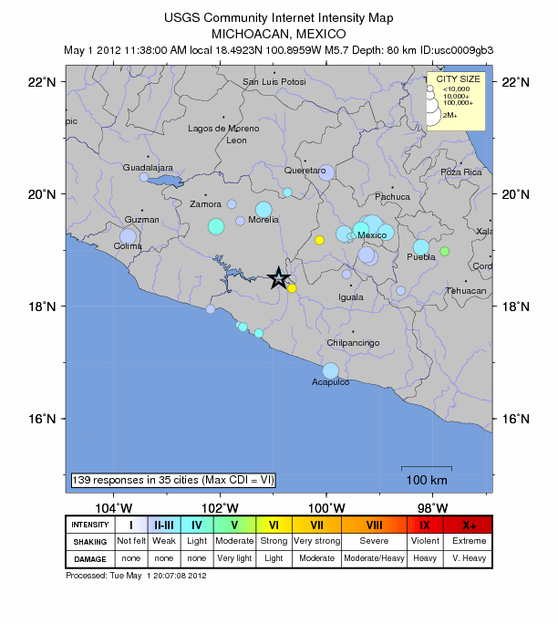
    May 2, 2012 – MEXICO – A magnitude 6.0 earthquake struck off southwest Mexico near the Guatemalan border on Tuesday, the U.S. Geological Service said. The earthquake was downgraded from a 6.3 magnitude by the USGS. The quake, which hit 51 miles (82 km) west-southwest of Suchiate, Chiapas, had a depth of 27.3 miles (43 km), the USGS said. Earlier on Tuesday, a 5.7 magnitude quake struck near MICHOACAN, 130 miles (210 km) from Mexico City shook the capital, but officials had no reports of damage in the city. –Euro News


    The Earthquake/Seismic Activity Log - Page 32 001
    http://www.reuters.com/article/2012/05/01/us-mexico-quake-idUSBRE84014720120501
    5.7 magnitude earthquake shakes buildings in Mexico City
    May 1, 2012 – MEXICO – An earthquake 130 miles away shook Mexico City on Tuesday but officials had no reports of damage in the capital. Traffic and street life continued as normal moments after the tremor that hit on a public holiday, witnesses said. “I’ve lived through plenty of earthquakes. But I didn’t feel that one,” said Elias Munoz, 70, who runs a kiosk in Mexico City’s central Roma. The U.S. Geological Survey said the quake that hit the central state of Michoacan had a magnitude of 5.7 and was recorded at a depth of 48 miles. The epicenter was 128 miles southwest of the Mexican capital. Fausto Vallejo, governor of Michoacan, said on his Twitter account there were no reports of damage in the state. Mexico City Mayor Marcelo Ebrard, tweeted that there were no reports of damage there. Mexico has felt several strong earthquakes in recent weeks such as a 7.4 magnitude tremor in late March, without serious damage. -Reuters


    _________________
    What is life?
    It is the flash of a firefly in the night, the breath of a buffalo in the wintertime. It is the little shadow which runs across the grass and loses itself in the sunset.

    With deepest respect ~ Aloha & Mahalo, Carol
    Carol
    Carol
    Admin
    Admin


    Posts : 32911
    Join date : 2010-04-07
    Location : Hawaii

    The Earthquake/Seismic Activity Log - Page 32 Empty Re: The Earthquake/Seismic Activity Log

    Post  Carol Thu May 03, 2012 10:09 am

    The Earthquake/Seismic Activity Log - Page 32 WorldIMap
    Looks like two 5.5s on in iran/iraq one in china is also being triggered in conjunction with a heated F-region of the ionosphere
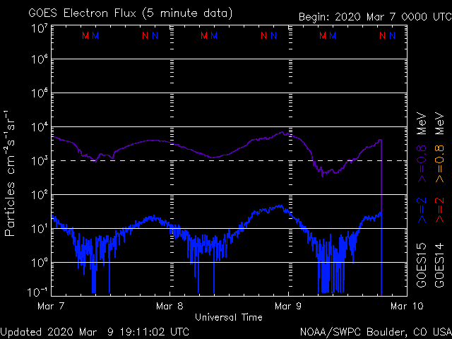
    According to one source earths geomagnetic field has completely or nearly completely failed. One solar particle during this period could trigger a magnetic pole reversal. Is it possible that the widespread reports of tinnitus are caused by stimulation of the cochlear nerves by particle radiation?

    The Earthquake/Seismic Activity Log - Page 32 Electron
    The Earthquake/Seismic Activity Log - Page 32 Noaa_elec_3d
    Two Major Quake Precursors Next 3 to 4 Days: Super Moon and Huge Drop in Electron Flux
    This is usually a reliable quake precursor signal.

    Last time this happened, there was a 7.1 Quake in Maule, Chili

    Poland 3.5
    http://quakes.globalincidentmap.com//map_detail.php?id=186529

    Iran / Iraq border region 5.5
    http://quakes.globalincidentmap.com//map_detail.php?id=186534

    4.0 in the Vancouver Island region of Canada
    http://www.earthquakesummary.info/

    Largest quake potential appears to be Saturday, the 5th, with a possible 8+ Quake
    M5+ World Earthquakes in Last 7 Days (RSS - USGS)
    http://seismo.info/

    The Earthquake/Seismic Activity Log - Page 32 N_stddev_timeseries
    http://nsidc.org/data/seaice_index/images/daily_images/N_stddev_timeseries.png
    "Noting the near vertical plunge near the end of the 2012 line - if it continues with that trend the ice WILL be totally gone my August."


    _________________
    What is life?
    It is the flash of a firefly in the night, the breath of a buffalo in the wintertime. It is the little shadow which runs across the grass and loses itself in the sunset.

    With deepest respect ~ Aloha & Mahalo, Carol
    Carol
    Carol
    Admin
    Admin


    Posts : 32911
    Join date : 2010-04-07
    Location : Hawaii

    The Earthquake/Seismic Activity Log - Page 32 Empty Re: The Earthquake/Seismic Activity Log

    Post  Carol Thu May 03, 2012 10:26 pm

    Moderate 5.5 magnitude earthquake destroys 30 homes and injures 8 in Iran
    May 4, 2012 – TEHRAN, Iran — A moderate earthquake jolted a small town in western Iran near the Iraqi border on Thursday, injuring eight people and damaging buildings, Iranian media reported. The magnitude 5.5 quake hit the sparsely populated area near the town of Mourmouri, about 300 miles (480 kilometers) southwest of the capital Tehran, at 2:39 p.m., said the semiofficial Mehr news agency. The report said the quake sent people rushing out of their homes in Mourmouri and that scores of buildings were damaged in nearby towns of Abdanan and Dehloran. The area has experienced dozens of moderate earthquakes over the past few weeks. The earthquake destroyed 30 houses and left eight people injured, an official said. Iran is located on seismic fault lines and is prone to earthquakes, experiencing at least one slight quake a day on average. In 2003, some 26,000 people were killed by a magnitude 6.6 quake that flattened the historic southeastern city of Bam. –Huffington Post


    Swarm of earthquakes rippling through Western Turkey
    May 4, 2012 – TURKEY - A 5.1-magnitude earthquake hit the Kutahya province in western Turkey, the Istanbul-based Kandilli seismology center reported. The quake occurred at 6:20 pm local time with its epicenter in Tokat village of Hiharcik town in Kutahya, according to the seismology center affiliated to Bogazici University. The epicenter, with a depth of 3.1 km, was felt in some towns near Hiharcik and many citizens ran out of their houses in the province with panic. –Ynet News


    _________________
    What is life?
    It is the flash of a firefly in the night, the breath of a buffalo in the wintertime. It is the little shadow which runs across the grass and loses itself in the sunset.

    With deepest respect ~ Aloha & Mahalo, Carol
    Carol
    Carol
    Admin
    Admin


    Posts : 32911
    Join date : 2010-04-07
    Location : Hawaii

    The Earthquake/Seismic Activity Log - Page 32 Empty Re: The Earthquake/Seismic Activity Log

    Post  Carol Mon May 07, 2012 10:36 am

    Earthquakes Worldwide
    in the Last 5 Days

    (of magnitude >= 4.0)


    DATE LAT LON MAG DEPTH km REGION
    07-MAY-2012 14:15:15 41.58 46.74 5.6 11.3 EASTERN CAUCASUS
    07-MAY-2012 08:36:24 41.18 46.82 4.1 21.2 EASTERN CAUCASUS
    07-MAY-2012 07:40:37 36.67 21.53 4.0 39.9 SOUTHERN GREECE
    07-MAY-2012 07:08:12 19.78 -109.26 4.3 40.6 REVILLA GIGEDO ISLANDS REGION
    07-MAY-2012 06:46:58 -15.15 -173.34 5.1 39.0 TONGA ISLANDS
    07-MAY-2012 05:38:04 41.52 46.74 4.2 14.9 EASTERN CAUCASUS
    07-MAY-2012 05:25:34 16.57 -98.22 4.4 31.3 NEAR COAST OF GUERRERO, MEXICO
    07-MAY-2012 04:40:29 41.54 46.77 5.1 23.3 EASTERN CAUCASUS
    07-MAY-2012 04:00:36 55.09 165.62 4.4 38.7 KOMANDORSKY ISLANDS REGION
    07-MAY-2012 03:27:23 -25.32 179.75 5.6 503.2 SOUTH OF FIJI ISLANDS
    07-MAY-2012 03:02:23 -19.98 -69.11 4.7 85.5 NORTHERN CHILE
    07-MAY-2012 00:29:10 27.50 58.69 4.1 10.0 SOUTHERN IRAN
    06-MAY-2012 23:03:57 -6.68 130.11 4.1 153.0 BANDA SEA
    06-MAY-2012 19:26:46 45.32 149.33 4.7 103.7 KURIL ISLANDS
    06-MAY-2012 16:58:34 -0.57 98.59 4.3 52.5 SOUTHERN SUMATERA, INDONESIA
    06-MAY-2012 12:41:01 -13.81 -75.73 5.1 76.7 CENTRAL PERU
    06-MAY-2012 10:23:40 2.08 126.17 4.7 68.3 NORTHERN MOLUCCA SEA
    06-MAY-2012 08:33:47 -36.27 -99.38 4.7 10.2 SOUTHEAST OF EASTER ISLAND
    06-MAY-2012 08:19:58 4.00 92.68 4.5 10.0 OFF W COAST OF NORTHERN SUMATERA
    06-MAY-2012 07:22:23 55.19 164.00 4.1 19.5 KOMANDORSKY ISLANDS REGION
    06-MAY-2012 05:54:05 12.64 -44.54 4.9 9.5 NORTHERN MID-ATLANTIC RIDGE
    06-MAY-2012 05:03:44 2.22 96.59 4.4 41.9 NORTHERN SUMATERA, INDONESIA
    06-MAY-2012 00:10:18 -10.68 -78.23 4.4 73.8 NEAR COAST OF PERU
    05-MAY-2012 23:33:12 -41.46 174.82 4.2 42.6 COOK STRAIT, NEW ZEALAND
    05-MAY-2012 23:06:52 -31.51 -68.97 4.4 97.5 SAN JUAN PROVINCE, ARGENTINA
    05-MAY-2012 21:40:31 -28.81 -68.68 4.5 76.5 LA RIOJA PROVINCE, ARGENTINA
    05-MAY-2012 20:34:04 -5.55 147.16 4.8 205.5 EASTERN NEW GUINEA REG., P.N.G.
    05-MAY-2012 20:23:31 -21.40 -174.13 5.5 3.9 TONGA ISLANDS
    05-MAY-2012 20:12:34 38.19 141.67 5.2 50.9 NEAR EAST COAST OF HONSHU, JAPAN
    05-MAY-2012 20:09:36 3.72 124.79 4.3 315.4 CELEBES SEA
    05-MAY-2012 18:43:20 5.76 126.40 4.8 106.3 MINDANAO, PHILIPPINE ISLANDS
    05-MAY-2012 17:12:45 12.11 144.31 4.6 43.5 SOUTH OF MARIANA ISLANDS
    05-MAY-2012 15:55:06 40.21 19.76 4.4 10.6 ALBANIA
    05-MAY-2012 12:08:43 4.80 87.90 4.9 10.0 NORTH INDIAN OCEAN
    05-MAY-2012 11:00:56 47.21 149.58 4.7 259.2 NORTHWEST OF KURIL ISLANDS
    05-MAY-2012 09:48:04 16.74 -97.00 4.1 17.8 OAXACA, MEXICO
    05-MAY-2012 09:23:23 38.80 -122.76 4.3 2.8 NORTHERN CALIFORNIA
    05-MAY-2012 08:11:59 35.44 140.84 4.5 19.2 NEAR EAST COAST OF HONSHU, JAPAN
    05-MAY-2012 05:58:37 33.22 95.55 4.4 10.0 QINGHAI, CHINA
    05-MAY-2012 03:34:01 3.61 86.76 4.8 10.0 NORTH INDIAN OCEAN
    05-MAY-2012 02:30:49 67.88 -167.09 4.1 11.0 BERING STRAIT
    05-MAY-2012 02:05:52 14.22 -93.11 4.2 10.0 NEAR COAST OF CHIAPAS, MEXICO
    05-MAY-2012 01:57:14 34.87 44.17 4.4 42.8 IRAQ
    05-MAY-2012 00:20:13 -41.47 -91.83 4.7 10.0 SOUTHEAST OF EASTER ISLAND
    05-MAY-2012 00:11:12 -41.10 -91.10 4.9 10.0 SOUTHEAST OF EASTER ISLAND
    05-MAY-2012 00:04:15 -6.36 124.97 4.2 560.5 BANDA SEA
    04-MAY-2012 23:33:25 83.02 -6.90 4.3 10.0 NORTH OF SVALBARD
    04-MAY-2012 20:09:23 27.30 95.37 4.5 14.1 MYANMAR-INDIA BORDER REGION
    04-MAY-2012 18:57:51 14.48 -91.33 4.3 89.0 GUATEMALA
    04-MAY-2012 17:58:47 -24.59 -177.08 4.9 37.9 SOUTH OF FIJI ISLANDS
    04-MAY-2012 16:23:43 2.01 89.68 5.0 14.5 NORTH INDIAN OCEAN
    04-MAY-2012 10:55:40 50.77 -129.99 4.4 10.0 VANCOUVER ISLAND REGION
    04-MAY-2012 07:06:56 16.44 -98.82 4.1 10.0 NEAR COAST OF GUERRERO, MEXICO
    04-MAY-2012 06:29:41 -5.19 151.99 4.5 62.8 NEW BRITAIN REGION, P.N.G.
    04-MAY-2012 05:38:13 40.31 27.00 4.1 11.3 TURKEY
    04-MAY-2012 05:34:09 43.31 145.44 4.6 94.1 HOKKAIDO, JAPAN REGION
    04-MAY-2012 02:54:10 35.50 140.04 4.5 67.9 NEAR EAST COAST OF HONSHU, JAPAN
    04-MAY-2012 02:31:31 -5.44 152.21 4.8 59.9 NEW BRITAIN REGION, P.N.G.
    04-MAY-2012 02:00:36 39.14 29.12 4.5 6.5 TURKEY
    03-MAY-2012 21:45:19 39.04 29.21 4.1 15.0 TURKEY
    03-MAY-2012 21:20:36 46.94 150.55 5.0 150.9 KURIL ISLANDS
    03-MAY-2012 18:08:06 17.48 -85.14 5.2 24.0 NORTH OF HONDURAS
    03-MAY-2012 16:16:05 39.07 29.08 4.3 5.9 TURKEY
    03-MAY-2012 16:14:18 -5.47 152.08 5.3 45.1 NEW BRITAIN REGION, P.N.G.
    03-MAY-2012 15:20:26 39.07 29.10 5.2 9.9 TURKEY
    03-MAY-2012 15:17:05 37.79 21.03 4.6 38.2 SOUTHERN GREECE
    03-MAY-2012 14:28:59 -4.80 145.01 5.0 108.2 NEAR N COAST OF NEW GUINEA, PNG.
    03-MAY-2012 13:38:35 2.57 94.54 4.2 29.6 OFF W COAST OF NORTHERN SUMATERA
    03-MAY-2012 11:10:43 -23.66 179.10 4.8 562.5 SOUTH OF FIJI ISLANDS
    03-MAY-2012 11:10:28 14.43 -92.88 4.5 35.3 NEAR COAST OF CHIAPAS, MEXICO
    03-MAY-2012 10:19:37 40.51 98.57 5.0 13.0 WESTERN NEI MONGOL, CHINA
    03-MAY-2012 10:09:35 32.81 47.71 5.5 9.9 IRAN-IRAQ BORDER REGION
    03-MAY-2012 08:14:08 14.41 -92.90 4.2 62.8 NEAR COAST OF CHIAPAS, MEXICO
    03-MAY-2012 07:25:12 55.44 160.28 4.4 111.8 KAMCHATKA
    03-MAY-2012 06:42:37 36.36 70.71 4.7 144.9 HINDU KUSH REGION, AFGHANISTAN
    03-MAY-2012 06:24:25 36.04 33.73 4.0 5.0 TURKEY
    03-MAY-2012 05:17:46 21.36 -108.59 4.2 10.0 REVILLA GIGEDO ISLANDS REGION
    03-MAY-2012 04:59:56 21.43 -108.76 4.9 10.2 REVILLA GIGEDO ISLANDS REGION
    03-MAY-2012 04:56:15 21.22 -108.88 4.0 10.0 REVILLA GIGEDO ISLANDS REGION
    03-MAY-2012 01:57:50 38.61 26.70 4.3 12.5 AEGEAN SEA
    03-MAY-2012 01:18:09 10.07 93.15 4.8 79.4 ANDAMAN ISLANDS, INDIA


    _________________
    What is life?
    It is the flash of a firefly in the night, the breath of a buffalo in the wintertime. It is the little shadow which runs across the grass and loses itself in the sunset.

    With deepest respect ~ Aloha & Mahalo, Carol
    Carol
    Carol
    Admin
    Admin


    Posts : 32911
    Join date : 2010-04-07
    Location : Hawaii

    The Earthquake/Seismic Activity Log - Page 32 Empty Re: The Earthquake/Seismic Activity Log

    Post  Carol Wed May 09, 2012 10:39 pm

    The Earthquake/Seismic Activity Log - Page 32 Images?q=tbn:ANd9GcTbGAChvG-8pwzQG77hFv5p78_iUUyoBT7elGhqsv0JEs6ExSCY
    Civil Defense of Peru issues earthquake warnings after two days of abnormal tremor activity
    May 8, 2012 – PERU - The Civil Defense in Peru (Indeci) intensified today a prevention drive warning of a potential massive earthquake now preceded of two daily tremors average. Indeci called on every workplace and home to ready an emergency evacuation plan after a median quake and two replicas were recorded Sunday in Ica (south) and in Lima. Marco Tantalean, an expert from the institution, said planning must include safe routes and refuges, plus staples like your ID cards, drinkable water, first-aid material, flashlight, non perishable food and saving phone calls for emergencies to prevent the lines from collapsing. Other prevention measures include a May 31st tsunami simulation, marking the 1970 massive quake that killed some 70,000 people in Ancash, north Peru. Scientific evidence have proven that after “long periods of rest” big quakes may occur, like those that have especially razed Lima through history; plus, Peru is located in a seismic area, adds Hernando Tavera, director of Seismology at the Institute of Geophysics, reminding of the 66 tremors of 2012 through April, near one daily. The majority, 39, registered on the Pacific coast, again in Lima, Ica -devastated in 2007- and Arequipa, together occupy more than 1,000km. –Prensa Latina


    The Earthquake/Seismic Activity Log - Page 32 Neic_b0009l5s
    5.2 magnitude tectonic earthquake strikes off the coast of the Philippines
    May 9, 2012 – COTABATO, Philippines – A magnitude 5.2 earthquake jolted southern Philippines Wednesday, the Philippine Institute of Volcanology and Seismology (Phivolcs) said on Wednesday. According to Phivolcs, the quake, tectonic in origin with a depth of 34 km, was traced around 12:34 p.m. local time 150 km northeast of Tarragona town, in Davao Oriental. There were no reported casualties, said the agency. The Philippines sits in the so-called Pacific Ring of Fire, an area where continental plates collide, producing frequent earthquakes and volcanic activities. The worst earthquake in the country happened on August 16, 1976 after a tsunami caused by a quake killed between 5,000 and 8,000 people in the Moro Gulf region in southern Philippines. –Phil Star


    _________________
    What is life?
    It is the flash of a firefly in the night, the breath of a buffalo in the wintertime. It is the little shadow which runs across the grass and loses itself in the sunset.

    With deepest respect ~ Aloha & Mahalo, Carol
    Carol
    Carol
    Admin
    Admin


    Posts : 32911
    Join date : 2010-04-07
    Location : Hawaii

    The Earthquake/Seismic Activity Log - Page 32 Empty Re: The Earthquake/Seismic Activity Log

    Post  Carol Mon May 14, 2012 3:15 pm

    The Earthquake/Seismic Activity Log - Page 32 000chile
    6.2 magnitude earthquake strikes Tarapaca region of Chile
    May 14, 2012 – CHILE – A strong 6.2 magnitude earthquake shook the border area straddling southern Peru and northern Chile early on Monday, but there were no reports of damage, the Andean neighbors’ national emergency offices said. The U.S. Geological Survey said the quake struck 41 miles east-northeast of Tacna in Peru, and 66 miles northeast of Arica in the far north of world No. 1 copper producer Chile. The tremor hit at a depth of 61.1 miles, it said. The USGS had earlier reported two quakes of 5.9 magnitude had struck seconds apart, but later updated its Web site to show only one. There were no immediate reports of injuries or damage in Chile, said a spokeswoman for Chile’s state emergency office (ONEMI). A spokeswoman for Chile’s Collahuasi, the world’s No. 3 copper mine owned jointly by Anglo American Plc and Xstrata Plc, said its operations had not been affected by the quake. Union leader Manuel Munoz said the quake had however caused some rocks to fall on roads at the deposit. In Lima, a spokesman for the emergency operations center of the National Civil Defense Institute (INDECI) said there were no immediate reports of damage, though an official at Peru’s Geophysics Institute said electricity was disrupted in the southern Peruvian region near the border with Chile. Quakes are common in Chile, which was hit by a devastating 8.8 magnitude temblor in early 2010 which triggered tsunami that battered the south-central Chilean coastline in a disaster which killed around 500 people and ravaged industries. –Reuters


    _________________
    What is life?
    It is the flash of a firefly in the night, the breath of a buffalo in the wintertime. It is the little shadow which runs across the grass and loses itself in the sunset.

    With deepest respect ~ Aloha & Mahalo, Carol
    Carol
    Carol
    Admin
    Admin


    Posts : 32911
    Join date : 2010-04-07
    Location : Hawaii

    The Earthquake/Seismic Activity Log - Page 32 Empty Re: The Earthquake/Seismic Activity Log

    Post  Carol Mon May 14, 2012 3:29 pm

    The Earthquake/Seismic Activity Log - Page 32 Images?q=tbn:ANd9GcRHE7Db-wFwB3_uKSz3moPSQUhWtzWHf7nBLG1zzrLpKOk1TpVr
    5.7 earthquake in Tajikistan kills one and buries herds of livestock
    May 13, 2012 – TAJIKISTAN - One man was killed when a moderate, 5.7 magnitude earthquake struck in central Tajikistan early Sunday, damaging several buildings. The most damage occurred in the country’s Garm district, where one man was killed by a collapsing wall, Nargis Nurova of Tajikistan’s emergency situations committee told AFP. Two buildings were completely destroyed, and several more were damaged, she said. The quake also caused a mudslide, burying alive herds of cows and sheep, she added. The U.S. Geological Survey located the epicenter of the tremor, which occurred at 4:28 am (2328 GMT Saturday), at around 100 kilometres (60 miles) north of the city of Kulob at a depth of 10 kilometres. Residents in the capital Dushanbe some 140 kilometres (90 miles) away felt tremors of about magnitude 4.0, a representative of the geophysics department in Tajikistan’s Academy of Sciences told AFP. The reading was based on the open-ended Moment Magnitude scale, now used by US seismologists, which measures the area of the fault that ruptured and the total energy released. Tajikistan, a former Soviet republic in Central Asia, is mostly covered by mountains, with earthquakes occurring on a nearly monthly basis. -24/7


    5.5 earthquake reported south of Christchurch, New Zealand
    May 12, 2012 – NEW ZEALAND – Two earthquakes, magnitudes 3.9 and 5.5, have been detected near southern New Zealand. The 3.9 quakes was near the city of Christchurch, which in 2011 was damaged by another tremor. No damages and casualties are reported from the earthquakes this time over, as the stronger one was centered in a sparsely populated area. The 3.9 Richter earthquake was felt Sunday morning, with an epicenter some 10 km away from Christchurch. It was preceded several hours earlier by the 5.5 tremor near the southern shores of New Zealand, which was felt all over the southern island. –Novinite


    5.3 magntiude offshore earthquake rattles Israel and Palestine
    May 12, 2012 – ISRAEL – An earthquake rocked Israel on Friday evening, shortly before 10:00 p.m. local time, and was felt in areas from northern Israel to central Israel. According to a Channel 10 News report, the police in the Northern, Central and Tel Aviv Districts said they received hundreds of phone calls from citizens who felt the earthquake. Local residents reported feeling objects and buildings move for about 15 to 20 seconds. There were no reports of injuries or damages. The U.S. Geological Survey said the earthquake measured 5.3 on the Richter scale and its epicenter was in Cyprus. More than a 100 calls by concerned citizens were received in the northern city of Tzfat alone, the report said. The quake was felt even in Bat Yam, Kfar Saba, Ramat Hasharon, Ra’anana and other areas in central Israel. Magen David Adom has sent reinforcements to its stations in northern Israel and is preparing for the possibility of secondary tremors, Channel 10 reported. In February, a 3.1 magnitude tremor shook Israel’s north. There were no injuries or damage following the earthquake. The epicenter of that earthquake was east of Lake Kinneret, and a number of communities in the area reported having felt the quake. Experts have warned that Israel is expected to be hit by a major earthquake. Dr. Ephraim Laor, who headed the National Steering Committee for Earthquake Preparedness, told Arutz Sheva recently that each Israeli must prepare himself for a major earthquake that could hit Israel. In February, school children around the country, from kindergarten age and up, participated in earthquake drills in their schools, practicing safe steps to take when the ground starts shaking. –Arutz Sheva


    Last edited by Carol on Mon May 14, 2012 3:35 pm; edited 1 time in total


    _________________
    What is life?
    It is the flash of a firefly in the night, the breath of a buffalo in the wintertime. It is the little shadow which runs across the grass and loses itself in the sunset.

    With deepest respect ~ Aloha & Mahalo, Carol
    Carol
    Carol
    Admin
    Admin


    Posts : 32911
    Join date : 2010-04-07
    Location : Hawaii

    The Earthquake/Seismic Activity Log - Page 32 Empty Re: The Earthquake/Seismic Activity Log

    Post  Carol Mon May 14, 2012 3:33 pm

    DATE LAT LON MAG DEPTH km REGION
    14-MAY-2012 10:12:35 27.94 57.75 4.4 25.0 SOUTHERN IRAN
    14-MAY-2012 10:00:30 -17.72 -69.70 6.1 22.3 PERU-BOLIVIA BORDER REGION
    14-MAY-2012 07:57:50 1.72 -100.73 4.4 10.1 GALAPAGOS TRIPLE JUNCTION REGION
    14-MAY-2012 06:46:27 38.81 48.69 4.0 50.6 ARMENIA-AZERBAIJAN-IRAN BORD REG
    14-MAY-2012 06:27:35 21.27 144.58 5.1 104.0 MARIANA ISLANDS REGION
    14-MAY-2012 04:50:28 -17.45 -177.41 5.3 366.2 FIJI ISLANDS REGION
    14-MAY-2012 03:36:44 31.77 131.59 4.6 8.4 KYUSHU, JAPAN
    14-MAY-2012 02:45:22 51.64 -175.00 4.5 26.7 ANDREANOF ISLANDS, ALEUTIAN IS.
    14-MAY-2012 01:11:28 13.28 -90.39 4.2 35.0 NEAR COAST OF GUATEMALA
    14-MAY-2012 00:29:47 7.71 -81.00 4.2 46.4 PANAMA
    14-MAY-2012 00:12:22 36.30 70.67 4.2 103.4 HINDU KUSH REGION, AFGHANISTAN
    13-MAY-2012 23:10:31 -7.19 129.25 4.7 167.2 BANDA SEA
    13-MAY-2012 22:46:11 -15.98 -179.62 4.3 4.8 FIJI ISLANDS REGION
    13-MAY-2012 18:44:38 51.15 -179.89 4.7 31.6 ANDREANOF ISLANDS, ALEUTIAN IS.
    13-MAY-2012 18:24:49 -3.78 128.79 4.8 121.9 SERAM, INDONESIA
    13-MAY-2012 18:21:17 27.10 53.92 4.9 45.5 SOUTHERN IRAN
    13-MAY-2012 13:48:14 32.73 47.66 4.3 40.7 IRAN-IRAQ BORDER REGION
    13-MAY-2012 12:42:49 -32.74 -71.80 4.8 11.9 NEAR COAST OF CENTRAL CHILE
    13-MAY-2012 12:30:58 2.54 90.48 4.6 14.6 OFF W COAST OF NORTHERN SUMATERA
    13-MAY-2012 11:55:00 -20.98 -177.90 4.5 495.3 FIJI ISLANDS REGION
    13-MAY-2012 11:29:39 -58.97 -26.18 4.8 138.8 SOUTH SANDWICH ISLANDS REGION
    13-MAY-2012 09:18:56 3.79 92.73 4.7 22.4 OFF W COAST OF NORTHERN SUMATERA
    13-MAY-2012 09:10:22 -1.20 100.26 4.6 80.6 SOUTHERN SUMATERA, INDONESIA
    13-MAY-2012 07:08:49 -30.66 -177.94 4.0 54.6 KERMADEC ISLANDS, NEW ZEALAND
    13-MAY-2012 05:09:49 60.10 -152.80 4.0 105.9 SOUTHERN ALASKA
    13-MAY-2012 04:46:06 -0.13 123.01 5.2 94.0 MINAHASSA PENINSULA, SULAWESI
    13-MAY-2012 04:42:48 -58.42 157.83 5.3 10.0 MACQUARIE ISLANDS REGION
    13-MAY-2012 03:05:47 37.41 141.11 4.3 71.4 NEAR EAST COAST OF HONSHU, JAPAN
    13-MAY-2012 02:35:35 -2.71 138.82 4.5 45.2 IRIAN JAYA, INDONESIA
    13-MAY-2012 02:00:12 3.78 92.70 4.9 10.0 OFF W COAST OF NORTHERN SUMATERA
    13-MAY-2012 01:19:09 -3.31 89.42 5.3 10.0 SOUTH INDIAN OCEAN
    13-MAY-2012 00:09:23 -15.95 36.04 4.6 10.0 MOZAMBIQUE
    12-MAY-2012 23:28:43 38.63 70.38 5.7 10.0 AFGHANISTAN-TAJIKISTAN BORD REG.
    12-MAY-2012 23:05:25 43.95 88.39 4.3 35.0 NORTHERN XINJIANG, CHINA
    12-MAY-2012 22:48:13 40.56 22.88 4.1 10.0 GREECE
    12-MAY-2012 22:17:45 1.03 92.92 4.4 10.0 OFF W COAST OF NORTHERN SUMATERA
    12-MAY-2012 22:08:39 38.59 143.16 4.5 35.0 OFF EAST COAST OF HONSHU, JAPAN
    12-MAY-2012 20:39:33 -3.27 135.93 4.8 47.7 IRIAN JAYA REGION, INDONESIA
    12-MAY-2012 17:08:56 55.88 161.33 4.4 197.2 NEAR EAST COAST OF KAMCHATKA
    12-MAY-2012 14:34:42 -23.75 -175.77 4.8 10.0 TONGA ISLANDS REGION
    12-MAY-2012 13:23:15 2.23 126.12 4.8 55.6 NORTHERN MOLUCCA SEA
    12-MAY-2012 10:30:25 2.38 90.46 4.6 10.0 OFF W COAST OF NORTHERN SUMATERA
    12-MAY-2012 09:33:08 52.80 -168.26 4.1 36.7 FOX ISLANDS, ALEUTIAN ISLANDS
    12-MAY-2012 05:39:08 56.38 -162.07 4.3 190.9 BRISTOL BAY
    12-MAY-2012 05:27:36 -34.90 -71.86 4.0 44.0 NEAR COAST OF CENTRAL CHILE
    12-MAY-2012 01:34:43 38.34 89.40 4.8 10.0 SOUTHERN XINJIANG, CHINA
    12-MAY-2012 00:58:06 50.63 -129.69 4.4 13.5 VANCOUVER ISLAND REGION
    12-MAY-2012 00:08:01 1.89 94.39 4.4 10.0 OFF W COAST OF NORTHERN SUMATERA
    11-MAY-2012 23:37:02 14.03 -92.06 4.4 60.7 NEAR COAST OF CHIAPAS, MEXICO
    11-MAY-2012 23:05:40 -8.87 119.10 4.5 118.3 FLORES REGION, INDONESIA
    11-MAY-2012 22:07:36 -46.22 167.24 5.5 12.0 OFF W. COAST OF S. ISLAND, N.Z.
    11-MAY-2012 21:08:20 53.06 -166.65 4.3 25.8 FOX ISLANDS, ALEUTIAN ISLANDS
    11-MAY-2012 20:34:26 30.67 138.76 5.1 400.1 SOUTH OF HONSHU, JAPAN
    11-MAY-2012 19:26:30 -23.55 -63.67 4.4 544.2 SALTA PROVINCE, ARGENTINA
    11-MAY-2012 18:48:30 34.34 34.17 5.4 21.7 CYPRUS REGION
    11-MAY-2012 18:37:25 45.72 151.59 5.0 44.2 KURIL ISLANDS
    11-MAY-2012 17:59:26 37.49 139.67 4.5 78.5 EASTERN HONSHU, JAPAN
    11-MAY-2012 12:41:31 26.21 92.87 4.4 11.4 NORTHEASTERN INDIA
    11-MAY-2012 10:18:13 37.74 102.05 5.0 31.0 GANSU, CHINA
    11-MAY-2012 10:02:16 1.93 93.61 4.3 10.0 OFF W COAST OF NORTHERN SUMATERA
    11-MAY-2012 08:36:18 17.18 -61.12 4.3 36.1 LEEWARD ISLANDS
    11-MAY-2012 07:33:00 52.06 -171.67 4.3 51.8 FOX ISLANDS, ALEUTIAN ISLANDS
    11-MAY-2012 06:54:03 -8.84 -79.33 4.3 60.0 NEAR COAST OF NORTHERN PERU
    11-MAY-2012 06:15:01 15.69 -88.81 4.4 10.0 HONDURAS
    11-MAY-2012 01:32:00 -6.10 154.84 4.5 199.4 SOLOMON ISLANDS
    11-MAY-2012 00:52:07 -3.08 129.52 4.4 35.0 SERAM, INDONESIA


    _________________
    What is life?
    It is the flash of a firefly in the night, the breath of a buffalo in the wintertime. It is the little shadow which runs across the grass and loses itself in the sunset.

    With deepest respect ~ Aloha & Mahalo, Carol
    Carol
    Carol
    Admin
    Admin


    Posts : 32911
    Join date : 2010-04-07
    Location : Hawaii

    The Earthquake/Seismic Activity Log - Page 32 Empty Re: The Earthquake/Seismic Activity Log

    Post  Carol Wed May 16, 2012 12:47 pm

    4.6 magnitude earthquake jolts Anchorage Alaksa
    May 16, 2012 – ALASKA
    - According to the National Weather Service, an earthquake strong enough to feel in Anchorage, Alaska’s largest city, and surrounding areas of upper Cook Inlet occurred at 7:03 a.m. Wednesday. According to a preliminary report from the NWS tsunami warning system, the quake’s epicenter was 10 miles southwest of Anchorage’s center, at a depth of 35 miles, and the magnitude measured 4.6 on the Richter scale. Initial reports may be revised as more data becomes available. The agency says that no tsunami will result from the quake. The Alaska Earthquake Information Center at University of Alaska Fairbanks lists the magnitude at 4.61 and epicenter 8 miles south of Anchorage at a depth of 37 miles. –Alaska Dispatch


    6.0 magnitude earthquake strikes region of Papua New Guinea
    http://www.news.com.au/breaking-news/magnitude-60-earthquake-hits-papua-new-guinea/story-e6frfku0-1226357553746
    May 16, 2012 – PAPUA NG - A 6.0-magnitude earthquake struck Papua New Guinea on Wednesday, but no tsunami warning was immediately issued. The quake hit the remote New Britain region at a depth of 154 kilometers, 512km northeast of Port Moresby, the US Geological Survey said. Powerful earthquakes are common in impoverished PNG, which sits on the so-called Pacific Ring of Fire, a hot spot for seismic activity due to friction between tectonic plates. A giant tsunami in 1998 killed more than 2,000 people near Aitape, on the country’s northwest coast. -News


    _________________
    What is life?
    It is the flash of a firefly in the night, the breath of a buffalo in the wintertime. It is the little shadow which runs across the grass and loses itself in the sunset.

    With deepest respect ~ Aloha & Mahalo, Carol
    Carol
    Carol
    Admin
    Admin


    Posts : 32911
    Join date : 2010-04-07
    Location : Hawaii

    The Earthquake/Seismic Activity Log - Page 32 Empty Re: The Earthquake/Seismic Activity Log

    Post  Carol Fri May 18, 2012 10:51 am

    6.2 magnitude earthquake strikes off the coast of Chile
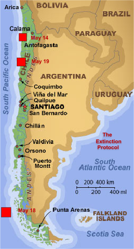
    May 18, 2012 – CHILE - A shallow 6.2 magnitude earthquake struck off the west coast of Chile at a depth of 10 km (6.2 miles). The epicenter of the earthquake was 542 km (336 miles) WSW of Castro, Los Lagos, Chile and some 1478 km (918 miles) SSW of SANTIAGO, Region Metropolitana, Chile. This is the second 6.2 magnitude earthquake to strike the coastal region of Chile in 4 days. A 6.2 quake struck Tarapaca on May 14. The Nazca plate is certainly letting us know that tension still resides on the plate. No tsunami warnings were issued with today’s earthquake and there have been no reports of damage or injuries.

    The Earthquake/Seismic Activity Log - Page 32 5.17-mystery-quake-2
    http://www.ktvb.com/home/Myster-quake-near-McCall-puzzles-scientists-151925345.html
    Mystery earthquake near McCall puzzles scientists, technicians
    Tales from the X-files: mystery earthquake in Idaho and beach rocks that spontaneous explode
    May 18, 2012 – MCCALL, Idaho — You could call it a mystery earthquake, a sonic boom, or maybe nothing at all. Several witnesses report waking up to what they say was a small earthquake south of McCall early Thursday around 4:30 a.m. However, those shaky claims have employees at Idaho’s U.S. Geological Survey scratching their heads in disbelief. Mickey Hart lives five miles south of McCall just off Highway 55. The 50-year-old resident said she’s experienced one previous earthquake here in the summer of 2001. The second earthquake came early Thursday around 4:30 a.m. Hart says that’s when her beloved border collie, Mr. Mac, detected the tremor before it hit. “It was four in the morning, and the house shook,” Hart said. “It woke up my husband and scared the crap out of my dog.” However, for some folks here in Idaho, those reports just don’t seem to make sense. U.S. Geological Survey Technical Information Specialist Tim Merrick said his agency’s seismographs haven’t shown any recent earthquake activity in Idaho. “If there was anything, it would almost certainly show up,” Merrick said. “Our seismology network across the United States is very sensitive.” Scott VanHoff, USGS Geospatial Mapping Coordinator, agrees. “Idaho looks amazingly quiet, and I don’t see anything,” VanHoff said, adding that the only earthquake he’d seen recorded was yesterday. USGS records show that event was a magnitude 2.2 earthquake recorded around 9:30 p.m., at a location northwest of Weiser, Idaho. However, other folks in the Valley County area maintain they positively did feel an earthquake early Thursday morning. Captain Brandon Swain with the McCall Fire Department says he heard reports of the mystery earthquake from his brother, Clint Swain, who lives near Lake Fork. “My brother was awake at about 4:30 or 5 a.m., and the earthquake woke up his wife,” Swain said. –KVTB


    The Earthquake/Seismic Activity Log - Page 32 Original
    Holy Hell, Rocks Are Now Spontaneously Exploding in People’s Pockets
    http://gawker.com/5911029/holy-hell-rocks-are-now-spontaneously-exploding-in-peoples-pockets
    Spontaneous exploding rocks: A 43-year-old woman in California suffered third-degree burns last Saturday after two rocks she’d collected at the beach spontaneous exploded while she was standing in her kitchen, causing her shorts to catch fire. The rocks were in her pocket. The Orange County Register reports that the woman tried to stop, drop, and roll to put out the flames. It didn’t help. But listen to what happened next: The rocks, described as small, the size of a hamburger patty, smooth and orange and green in color, fell from the shorts onto the floor and continued to burn the wood floor and fill the house with smoke. According to Orange County Fire Authority Captain Marc Stone, “The rocks were still smoking when firefighters took them to the hospital.” Captain Stone thinks the culprit might be phosphorous. “There is phosphorous that naturally occurs on the sand at the beach, but no one has ever heard of pants catching fire.” – Gawker – see also KSDK Channel 5


    _________________
    What is life?
    It is the flash of a firefly in the night, the breath of a buffalo in the wintertime. It is the little shadow which runs across the grass and loses itself in the sunset.

    With deepest respect ~ Aloha & Mahalo, Carol
    Carol
    Carol
    Admin
    Admin


    Posts : 32911
    Join date : 2010-04-07
    Location : Hawaii

    The Earthquake/Seismic Activity Log - Page 32 Empty Re: The Earthquake/Seismic Activity Log

    Post  Carol Sat May 19, 2012 5:56 pm

    The Earthquake/Seismic Activity Log - Page 32 01
    Moderate 5.9 strikes coastal region of Chile: tension is rising along the Nazca tectonic plate
    May 19, 2012 – CHILE – A 5.9 magnitude earthquake struck off the coast of Antofagasta, Chile. The depth of the earthquake was 25 km (15.5 m) and was downgraded from a 6.2 magnitude quake by the USGS. The epicenter of the earthquake was 54 km (33 miles) SW of Taltal, Antofagasta, Chile and 849 km (527 miles) N of Santiago, Chile. This is the third moderate earthquake to strike along the Chilean coastline in five days. A 6.2 magnitude earthquake struck off the southern coastal region of Aisen, Chile on May 18. A 6.2 earthquake also struck near Tarapaca on May 14. Tension continues to mount on the very dangerous Nazca plate which is violently diving or undergoing subduction under the South American plate. The absolute motion of the Nazca Plate has been calibrated at 3.7 cm/yr east motion (88°), some of the fastest absolute motion of any tectonic plate. The subducting Nazca Plate, which exhibits unusual flat-slab subduction, is tearing as well as deforming as it is subducted under the land mass. No tsunami warnings were issued with today’s 5.9 earthquake and there have been no reports of damage or injuries. Today’s earthquake, however, is one more indication tension along the Nazca tectonic plate is building. This region should remain alert for the potential occurrence of a stress-break or sizable release of seismic tension that could be manifested in a major earthquake.


    _________________
    What is life?
    It is the flash of a firefly in the night, the breath of a buffalo in the wintertime. It is the little shadow which runs across the grass and loses itself in the sunset.

    With deepest respect ~ Aloha & Mahalo, Carol
    mudra
    mudra


    Posts : 23307
    Join date : 2010-04-09
    Age : 70
    Location : belgium

    The Earthquake/Seismic Activity Log - Page 32 Empty Re: The Earthquake/Seismic Activity Log

    Post  mudra Sun May 20, 2012 4:21 am

    A magnitude 6.1 earthquake has occurred NORTHERN ITALY at:
    44.90N 11.24E Depth 10km 20/05/2012 at 02:03:53 (Universal Time)

    Earthquake location with respect to nearby cities:
    173 km E Milan (pop 1306661, local time 04:03:53.0 2012-05-20)
    30 km W Ferrara (pop 131771, local time 04:03:53.0 2012-05-20)
    7 km NW Finale emilia (pop 15337, local time 04:03:53.0 2012-05-20)

    Love Always
    mudra
    Carol
    Carol
    Admin
    Admin


    Posts : 32911
    Join date : 2010-04-07
    Location : Hawaii

    The Earthquake/Seismic Activity Log - Page 32 Empty Re: The Earthquake/Seismic Activity Log

    Post  Carol Sun May 20, 2012 10:55 am

    20 Seconds of Terror!!! A magnitude-6.0 earthquake shook northern Italy early today killing at least 6 people and toppling some buildings, emergency services and news reports said. The quake struck at 4.05 am Italian time between Modena and Mantova, about 35 kilometres (22 miles) north-northwest of Bologna at a relatively shallow depth of 10 kilometres (6 miles). It was one of the strongest quakes to shake the region, seismologists,and initial television footage indicated that older buildings had suffered damage: roofs collapsed, church towers showed cracks and the bricks of some stone walls tumbled into the street. As dawn broke over the region, residents milled about the streets inspecting the damage. Italian news agency ANSA, citing emergency services, said two people were killed in Sant'Agostino di Ferrara when a ceramics factory collapsed. Another person was killed in Ponte Rodoni do Bondeno, ANSA said. The epicentre was between the towns of Finale Emilia, San Felice sul Panaro and Sermide but was felt as far away as Tuscany and northern Alto Adige. The initial quake was followed about an hour later by a 6.0-magnitude temblor.
    A child of 5 years old pulled alive from the rubble. She is save by a miracle. 50 Injured.
    Civil Defense: "About three thousand displaced persons"

    The Earthquake/Seismic Activity Log - Page 32 120520062117-italy-quake-map-story-top
    Strong 6.0 magnitude earthquake strikes northern Italy killing 7


    _________________
    What is life?
    It is the flash of a firefly in the night, the breath of a buffalo in the wintertime. It is the little shadow which runs across the grass and loses itself in the sunset.

    With deepest respect ~ Aloha & Mahalo, Carol
    Carol
    Carol
    Admin
    Admin


    Posts : 32911
    Join date : 2010-04-07
    Location : Hawaii

    The Earthquake/Seismic Activity Log - Page 32 Empty Re: The Earthquake/Seismic Activity Log

    Post  Carol Sun May 20, 2012 11:09 am

    6.0 magnitude earthquake strikes off the coast of Japan
    May 20, 2012 – TOKYO - Japan was hit by two shallow earthquakes in the space of just eight minutes on Sunday, one of them measuring a strong 6.0-magnitude, but there were no reports of damage and no tsunami alert. The 6.2-magnitude quake struck at 4:20pm (0720 GMT) off Japan’s northeast Pacific coast, the national meteorological agency said, followed by a tremor with a reading of 5.7 at 4:28pm. The U.S. Geological Survey estimated the magnitude of the first quake at 6.0. The depth of both quakes was about 10 kilometers, the agency said. “Sea levels may change slightly due to the (first) earthquake but there is no fear of damage resulting from it,” the agency said in a statement. A 9.0-magnitude undersea earthquake off the same coast triggered a monster tsunami on March 11 last year, leaving about 19,000 people dead or missing and crippling the Fukushima nuclear power plant. –Deccan Times


    _________________
    What is life?
    It is the flash of a firefly in the night, the breath of a buffalo in the wintertime. It is the little shadow which runs across the grass and loses itself in the sunset.

    With deepest respect ~ Aloha & Mahalo, Carol
    Carol
    Carol
    Admin
    Admin


    Posts : 32911
    Join date : 2010-04-07
    Location : Hawaii

    The Earthquake/Seismic Activity Log - Page 32 Empty Re: The Earthquake/Seismic Activity Log

    Post  Carol Mon May 21, 2012 8:54 pm

    The Earthquake/Seismic Activity Log - Page 32 Bulgaria
    Strong shallow 5.6 magnitude earthquake strikes west Bulgaria
    May 22, 2012 – BULGARIA – A very strong shallow 5.6 magnitude earthquake has struck the region of Bulgaria north of Pernik. The depth of the earthquake was 9.1 km (5.7 miles) and the epicenter 24 km (14 miles) W of SOFIA, Bulgaria and east of Route 63 near Meshtitsa. SW Bulgaria is a region of the country especially prone to large seismic earthquakes. According to EMSC, a 5.2 magnitude earthquake aftershock struck about an hour after the original quake. The earthquake struck at around 3 am in the morning. There is no word yet on injuries or damage from today’s earthquake.


    Northern Italy earthquake leaves thousands homeless and terrified
    May 21, 2012 – ITALY - The epicentre of the 6.0-magnitude quake was in the province of Modena, but it was felt from Venice to Milan. It has left thousands homeless and reduced historic buildings in cities including Bologna and Verona to rubble. The quake hit in the early hours of Sunday (local time) as people were sleeping, sending terrified residents running into the street. “I am 83 and I have never felt anything like this,” Lina Gardenghi said in the town of Bondeno, near Ferrara. The quake was followed by a series of jolting aftershocks, sparking the evacuation of 3,000 people. At least two of the tremors reached magnitude-5.1, sowing fresh panic, further damaging already weakened buildings and causing more structures to collapse. The tremors were more deadly than any since 2009, when the central city of L’Aquila was devastated. Two of the dead suffered heart attacks, while one woman was crushed under a building that collapsed. The other four victims were night-shift workers in factories which collapsed, including two who were crushed when the roof of a ceramics factory caved in the town of Sant’Agostino. “He wasn’t supposed to be there,” the mother of one of the victims said. “He changed shifts with a friend who wanted to go to the beach.” Emergency workers are sifting through the rubble of collapsed buildings, searching for victims. Thousands of residents in towns around Ferrara have sought shelter in a gymnasium after being evacuated. “We will sleep here even if they don’t bring us beds or anything. At least it’s safe,” one man called Angelo said. He said his house shook so hard, it was impossible to flee from it. “When we were got on the street, it was like we were at sea, the ground was shaking,” he said. British tourist David Trew was in the town of Ferrara when the quake struck. “I woke up to what I initially thought was thunder, but of course the deep rumbling was accompanied by violent shaking of the room, with plaster falling onto my head and all around me,” he said. “I’ve never experienced an earthquake before, you know, frankly I was absolutely terrified.” Prime Minister Mario Monti cut short his trip to the United States and said the cabinet would declare a state of emergency, freeing up funds for quake relief. –ABC News


    Mystery boom rattles buildings and residents in Channel Islands
    http://www.thisisjersey.com/news/2012/05/21/mystery-boom-shakes-buildings/
    May 21, 2012 – CHANNEL ISLANDS – An investigation has been launched into the cause of a mysterious boom which shook buildings across the Island on Saturday afternoon. Hundreds of Islanders reported hearing a loud bang – similar to a sonic boom – at 1.04 pm. The boom was so loud it rattled doors and windows from Gorey to St Ouen and even measured on the Island’s seismograph in St Aubin. But despite speculation that the noise was caused by a military jet travelling faster than the speed of sound, Jersey Airport has confirmed that no aircraft capable of causing such a noise was in the Island’s airspace at the time. And Jersey Met Office has confirmed that it is unlikely that any meteorological phenomenon could have caused the noise. -TIJ


    Christchurch NZ has been rocked by a 4.8 magnitude earthquake on Sunday evening.
    http://www.radionz.co.nz/news/canterbury-earthquake/106266/magnitude-4-point-8-quake-hits-christchurch
    May 20, 2012 – NEW ZEALAND - Christchurch has been rocked by a 4.8 magnitude earthquake on Sunday evening. It follows a 4.1 magnitude quake four point one quake at 9.35am on Sunday. The 4.8 quake was centered 20 kilometers east of Christchurch at a depth of eight kilometers and struck at 5.06pm. The shaking lasted several seconds but so far there have been no reports of damage or injuries. The chief executive of the electricity lines company, Orion, says there have been no reports of power outages. Sunday morning’s quake measured 4.1 and was centered 20 kilometers west of Christchurch at a depth of 10km. The regularity and strength of earthquakes has continued to subside since the quakes felt just before Christmas which produced power outages and fresh liquefaction. –Radio New Zealand


    _________________
    What is life?
    It is the flash of a firefly in the night, the breath of a buffalo in the wintertime. It is the little shadow which runs across the grass and loses itself in the sunset.

    With deepest respect ~ Aloha & Mahalo, Carol
    Carol
    Carol
    Admin
    Admin


    Posts : 32911
    Join date : 2010-04-07
    Location : Hawaii

    The Earthquake/Seismic Activity Log - Page 32 Empty Re: The Earthquake/Seismic Activity Log

    Post  Carol Mon May 21, 2012 11:16 pm

    2012-05-20, 13:18:02.0 44.83 N 11.43 E 7 5.2 NORTHERN ITALY
    2012-05-20 08:20:57.0 39.67 N 143.32 E 10 5.6 OFF EAST COAST OF HONSHU, JAPAN
    2012-05-20 07:20:42.7 39.85 N 143.10 E 40 6.4 OFF EAST COAST OF HONSHU, JAPAN
    2012-05-20 07:19:55.0 39.56 N 143.25 E 10 6.0 OFF EAST COAST OF HONSHU, JAPAN
    2012-05-20 03:02:48.0 44.89 N 11.18 E 2 5.2 NORTHERN ITALY
    2012-05-20 02:03:53.0 44.90 N 11.24 E 10 6.1 NORTHERN ITALY Depth 5.1 km USGS
    2012-05-19 19:05:20.0 39.76 N 143.19 E 10 5.9 OFF EAST COAST OF HONSHU, JAPAN
    2012-05-19 08:35:08.0 25.74 S 70.66 W 10 6.0 ANTOFAGASTA, CHILE

    http://www.emsc-csem.org/Earthquake/seismologist.php
    http://earthquake.usgs.gov/earthquakes/recenteqsww/Quakes/usb0009uu3.php
    http://quakes.globalincidentmap.com/
    http://geofon.gfz-potsdam.de/eqinfo/event.php?from=rss&id=gfz2012jzll
    http://earthquake.usgs.gov/earthquakes/recenteqsww/Quakes/usb0009uyx.php


    _________________
    What is life?
    It is the flash of a firefly in the night, the breath of a buffalo in the wintertime. It is the little shadow which runs across the grass and loses itself in the sunset.

    With deepest respect ~ Aloha & Mahalo, Carol
    mudra
    mudra


    Posts : 23307
    Join date : 2010-04-09
    Age : 70
    Location : belgium

    The Earthquake/Seismic Activity Log - Page 32 Empty Re: The Earthquake/Seismic Activity Log

    Post  mudra Tue May 22, 2012 3:48 am

    Earthquake in Bulgaria felt in North Greece, too
    22 May 2012 |

    A strong earthquake measuring 5.8 on the Richter scale rocked Bulgaria at 3 a.m. on Tuesday, and was also felt in parts of Northern Greece, and especially Serres, eKathimerini informed.
    The tremor, whose epicentre was Pernik, a town on the outskirts of the capital, sent people out of their homes, though no serious injuries were reported by Greek or Bulgarian authorities.
    Pernik did suffer extensive structural damage and was put under emergency status as residents were evacuated over fears of strong aftershocks.

    http://www.focus-fen.net/?id=n278623

    Love Always
    mudra
    Carol
    Carol
    Admin
    Admin


    Posts : 32911
    Join date : 2010-04-07
    Location : Hawaii

    The Earthquake/Seismic Activity Log - Page 32 Empty Re: The Earthquake/Seismic Activity Log

    Post  Carol Wed May 23, 2012 1:30 pm

    The Earthquake/Seismic Activity Log - Page 32 Japan-may-23
    May 23, 2012 – JAPAN – A 6.1 magnitude earthquake have struck off the northeast coast of Japan at a depth of 40 km (25.3 miles). The epicenter of the earthquake was 109 km (68 miles) NNE (26°) from Hachinohe, Honshu, Japan and some 666 km (414 miles) NNE (17°) from TOKYO, Japan. Today’s earthquake is only the latest in an escalating series of recent earthquakes plaguing the eastern shores of Japan. A 6.4 magnitude earthquake struck off the coast of Honshu, Japan on May 20, 2012.


    The Earthquake/Seismic Activity Log - Page 32 Images?q=tbn:ANd9GcSY7RcwtbwCTUXQPueWiJWz52AEqpD13VpmX28Xj0Xx3dbXQ7K0Bg
    Researchers find New Zealand more seismically unstable than previously thought
    May 23, 2012 – NEW ZEALAND – Researchers have discovered New Zealand’s earthquake-prone landscape is even more unstable than previously thought, recording deep tremors lasting up to 30 minutes on its biggest fault line. Scientists measured the so-called “creeping earthquakes” when they investigated a puzzling lack of major seismic jolts along a section of the Alpine Fault, which runs the length of the South Island. The quakes, which caused no surface damage, occurred 20-45 kilometres (12-28 miles) beneath the Earth’s crust and continued for as long as half an hour, much longer than ordinary earthquakes. In contrast, the 6.3-magnitude quake that killed 185 people in the South island city of Christchurch in February last year lasted just 37 seconds and struck at a depth of about five kilometres. The quakes could not be measured by regular seismic monitoring devices and researchers from Wellington’s Victoria University had to place sensors in boreholes 100 metres deep to pick them up. Seismologist Aaron Wech said the research showed the Alpine Fault, regarded as New Zealand’s most hazardous, did not remain still between major earthquakes but was constantly shifting. Wech said the implications for future earthquakes were unclear. “It could be that constant tremor builds up stress and may trigger a major fault movement (earthquake) or, alternatively, the activity may decrease the likelihood of a major quake by acting as a release valve for stress,” he said. “What’s important is that we find out more about these tremor events, such as where they happen and how often, so we can better predict the hazard the Alpine Fault poses.” The research was published this week in the U.S. journal Geophysical Research Letters. The government’s GNS Science agency estimates the Alpine Fault has generated four quakes of magnitude 8.0 or higher in the past 900 years, most recently in the early 1700s, and another is overdue. It says there is a high probability one will occur in the next 40 years, producing “one of the biggest earthquakes since European settlement of New Zealand (which) will have a major impact on the lives of many people.” The Christchurch earthquake was not caused by the Alpine Fault but a previously unknown fault line, part of a network of seismic fractures criss-crossing New Zealand, which lies on the junction of two tectonic plates. -AFP


    The Earthquake/Seismic Activity Log - Page 32 Colexico
    4.0 earthquake near Calexico shows growing tension along plate boundary
    May 23, 2012 – CALEXICO, Calif. — A small earthquake has shaken the California-Mexico border region near the Imperial County city of Calexico. The U.S. Geological Survey says the magnitude-4 temblor occurred at 8:06 a.m. Tuesday. The epicenter was a dozen miles west of Calexico and 76 miles east of Tijuana. –Sac Bee


    _________________
    What is life?
    It is the flash of a firefly in the night, the breath of a buffalo in the wintertime. It is the little shadow which runs across the grass and loses itself in the sunset.

    With deepest respect ~ Aloha & Mahalo, Carol
    Carol
    Carol
    Admin
    Admin


    Posts : 32911
    Join date : 2010-04-07
    Location : Hawaii

    The Earthquake/Seismic Activity Log - Page 32 Empty Re: The Earthquake/Seismic Activity Log

    Post  Carol Tue May 29, 2012 1:17 am

    Deep 6.7 magnitude earthquake strikes northern Argentina
    http://thestar.com.my/news/story.asp?file=/2012/5/28/worldupdates/2012-05-28T052934Z_1_BRE84R02W_RTROPTT_0_UK-QUAKE-ARGENTINA&sec=Worldupdates
    May 28, 2012 – ARGENTINA – A magnitude 6.7 earthquake struck northern Argentina early on Monday, the U.S. Geological Survey said. The quake occurred at 2:07 a.m. local time (5.07 a.m. British time) and was centered 72 miles (116 km) east-southeast of Santiago del Estero, the USGS said. There were no immediate reports of injuries or damage from the quake, which was upgraded from an initial 6.4. –Malaysian Star

    DATE LAT LON MAG DEPTH km REGION
    29-MAY-2012 03:33:26 -22.01 -179.49 5.9 605.4 SOUTH OF FIJI ISLANDS
    29-MAY-2012 02:40:57 54.37 168.88 5.7 36.5 KOMANDORSKY ISLANDS REGION
    28-MAY-2012 21:47:11 -19.86 -175.89 5.8 226.6 TONGA ISLANDS
    28-MAY-2012 05:07:23 -28.06 -63.11 6.4 589.3 SANTIAGO DEL ESTERO PROV., ARG.
    26-MAY-2012 21:48:09 26.86 140.20 5.5 471.7 BONIN ISLANDS REGION
    25-MAY-2012 07:26:24 50.39 -129.74 4.1 10.0 VANCOUVER ISLAND REGION
    25-MAY-2012 06:23:29 52.35 -172.09 4.4 81.3 ANDREANOF ISLANDS, ALEUTIAN IS.
    25-MAY-2012 04:36:06 -22.44 -173.97 5.5 23.9 TONGA ISLANDS REGION
    25-MAY-2012 04:01:36 72.87 5.43 5.0 10.0 NORWEGIAN SEA
    25-MAY-2012 03:59:28 37.70 141.62 4.8 41.0 NEAR EAST COAST OF HONSHU, JAPAN
    25-MAY-2012 02:44:49 -43.51 172.94 4.8 9.7 SOUTH ISLAND, NEW ZEALAND
    25-MAY-2012 00:25:56 72.95 5.48 5.0 10.3 NORWEGIAN SEA
    24-MAY-2012 23:46:17 72.94 5.43 4.7 9.7 NORWEGIAN SEA
    24-MAY-2012 22:47:46 72.99 5.65 6.2 8.8 NORWEGIAN SEA


    _________________
    What is life?
    It is the flash of a firefly in the night, the breath of a buffalo in the wintertime. It is the little shadow which runs across the grass and loses itself in the sunset.

    With deepest respect ~ Aloha & Mahalo, Carol
    Carol
    Carol
    Admin
    Admin


    Posts : 32911
    Join date : 2010-04-07
    Location : Hawaii

    The Earthquake/Seismic Activity Log - Page 32 Empty Re: The Earthquake/Seismic Activity Log

    Post  Carol Tue May 29, 2012 8:06 pm

    An earthquake of a magnitude of 5.8 has shaken northern Italy. It struck 40 kilometres north of Bologna and 60 kilometres east of Parma at a depth of 9.6 kilometres, according to the US Geological Survey. Early reports said one person was killed and four injured. The quake was felt as far away as Milan. It is not known at this stage what damage has been caused to buildings. The tremor comes nine days after another earthquake in the region that killed seven people and left widespread damage.


    (Reuters) - An earthquake killed 16 people and injured about 350 in northern Italy on Tuesday, spreading fear among thousands of residents living in tents after a similarly strong tremor in the same region flattened their homes nine days ago.

    Rescuers were searching through the rubble of houses and warehouses in the Emilia-Romagna region, where several building sites had just reopened after the previous quake on May 20.

    Officials said 16 people were confirmed dead, more than twice the number killed in the May 20 quake that, like Tuesday's, had its epicenter near the city of Modena. The number of those forced to leave their homes doubled to 14,000.

    Many residents ran out of buildings when they felt the 5.8-magnitude tremor, which hit shortly after 3 a.m. EDT just as operations to rebuild the quake-struck region were under way. http://www.reuters.com/article/2012/05/29/us-italy-quake-usgs-idUSBRE84S09920120529

    DATE LAT LON MAG DEPTH km REGION
    29-MAY-2012 10:55:57 44.86 10.99 5.6 NORTHERN ITALY
    29-MAY-2012 07:00:03 44.81 11.08 5.8 NORTHERN ITALY
    29-MAY-2012 03:33:26 -22.01 -179.49 5.9 SOUTH OF FIJI ISLANDS
    29-MAY-2012 02:40:57 54.37 168.88 5.7 KOMANDORSKY ISLANDS REGION
    28-MAY-2012 21:47:11 -19.86 -175.89 5.8 TONGA ISLANDS
    28-MAY-2012 05:07:23 -28.06 -63.11 6.4 SANTIAGO DEL ESTERO PROV., ARG.
    26-MAY-2012 21:48:09 26.86 140.20 5.5 BONIN ISLANDS REGION


    _________________
    What is life?
    It is the flash of a firefly in the night, the breath of a buffalo in the wintertime. It is the little shadow which runs across the grass and loses itself in the sunset.

    With deepest respect ~ Aloha & Mahalo, Carol
    Carol
    Carol
    Admin
    Admin


    Posts : 32911
    Join date : 2010-04-07
    Location : Hawaii

    The Earthquake/Seismic Activity Log - Page 32 Empty Re: The Earthquake/Seismic Activity Log

    Post  Carol Wed May 30, 2012 12:10 pm

    Channel Islands 4.0 Earthquake Felt In Malibu, West LA, Culver City & San Fernando Valley
    http://www.huffingtonpost.com/2012/05/30/channel-islands-earthquake_n_1554820.html


    _________________
    What is life?
    It is the flash of a firefly in the night, the breath of a buffalo in the wintertime. It is the little shadow which runs across the grass and loses itself in the sunset.

    With deepest respect ~ Aloha & Mahalo, Carol

      Current date/time is Tue Nov 19, 2024 12:39 am