tMoA

Would you like to react to this message? Create an account in a few clicks or log in to continue.
tMoA

~ The only Home on the Web You'll ever need ~

+21
Aquaries1111
giovonni
arvan33
Floyd
lawlessline
JesterTerrestrial
THEeXchanger
newel
Brook
greybeard
Mercuriel
Sanicle
devakas
hobbit
mudra
burgundia
lindabaker
LeeEllisMusic
MargueriteBee
Carol
HigherLove
25 posters

    The Earthquake/Seismic Activity Log

    HigherLove
    HigherLove


    Posts : 2357
    Join date : 2011-01-27
    Age : 59

    The Earthquake/Seismic Activity Log - Page 17 Empty Re: The Earthquake/Seismic Activity Log

    Post  HigherLove Fri Sep 02, 2011 9:24 am

    Central California has been having a lot of quakes in the the 2 to 3 range for a bit. There were several quakes in L.A. yesterday, with one being a 4.2. Nor Cal remains remarkably quiet...
    ___________________________________________________

    Magnitude
    6.8
    Date-Time
    Friday, September 02, 2011 at 10:55:54 UTC
    Friday, September 02, 2011 at 01:55:54 AM at epicenter
    Time of Earthquake in other Time Zones
    Location
    52.185°N, 171.684°W
    Depth
    35.5 km (22.1 miles)
    Region
    FOX ISLANDS, ALEUTIAN ISLANDS, ALASKA
    Distances
    45 km (27 miles) SW of Amukta Island, Alaska
    85 km (52 miles) SW of Yunaska Island, Alaska
    1658 km (1030 miles) WSW of Anchorage, Alaska
    2410 km (1497 miles) W of WHITEHORSE, Yukon Territory, Canada
    Location Uncertainty
    horizontal +/- 14 km (8.7 miles); depth +/- 4.4 km (2.7 miles)
    Parameters
    NST=824, Nph=825, Dmin=172.5 km, Rmss=0.81 sec, Gp= 54°,
    M-type=centroid moment magnitude (Mw), Version=9
    Source
    Magnitude: USGS NEIC (WDCS-D)
    Location: USGS NEIC (WDCS-D)
    Event ID
    usc0005n83

    _________________________________

    Earthquakes list September 2, 2011
    Very dangerous : ALASKA
    Not dangerous : New Zealand, Argentina, Western Iran, Peru Ecuador border, Turkey, USA (California), Indonesia, Greece

    http://earthquake-report.com/
    Carol
    Carol
    Admin
    Admin


    Posts : 32911
    Join date : 2010-04-07
    Location : Hawaii

    The Earthquake/Seismic Activity Log - Page 17 Empty Re: The Earthquake/Seismic Activity Log

    Post  Carol Sat Sep 03, 2011 11:11 am

    The Earthquake/Seismic Activity Log - Page 17 Mount-hood-100805-02
    Scientists find major earthquake fault under Mount Hood
    September 2, 2011 – PORTLAND, Or. – Mount Hood, the tallest mountain in Oregon, has a secret, scientists revealed. Covered by trees and plants is an earthquake fault that stretches for miles from the iconic mountain. The fault appears to have been recently active, and could be an earthquake threat today, reported the Portland Oregonian. Scientists said the last time the fault ruptured, possibly as a magnitude 6 or 7 earthquake, the ground ripped six feet (1.8 meters) apart. The fault was discovered by scientists flying over Mt. Hood using lasers to scan the terrain. The fault is about 20 miles (32.2 kilometers) long and stretches from the northern flank of Mount Hood to the Columbia River. Earthquakes are not a foreign concept to Oregonians. The nearby Cascadia Subduction Zone could unleash a magnitude 9 earthquake, similar to the size of the deadly earthquake that ruptured in Japan. Scientists aren’t sure how big of an earthquake could rupture from the new Mount Hood fault. The research team, from the Oregon Department of Geology and Mineral Industries, are now working to estimate the threat that the fault poses to nearby communities. “We don’t know where all the seismic faults exist in Oregon. We don’t know how often they cause earthquakes,” Oregon State University engineer Michael Olsen, told the Oregonian. “That leads to a lot of uncertainty when we try to design buildings,” he says, that are sufficiently resistant to earthquake damage. In the coming weeks, scientists will dig a trench above the fault line so they can examine the soil for clues about past earthquakes. Looking at how the gravel and dirt has settled after past quakes could tell scientists about the size of previous quakes along the fault. http://www.ouramazingplanet.com/mount-hood-hidden-fault-1953/


    _________________
    What is life?
    It is the flash of a firefly in the night, the breath of a buffalo in the wintertime. It is the little shadow which runs across the grass and loses itself in the sunset.

    With deepest respect ~ Aloha & Mahalo, Carol
    HigherLove
    HigherLove


    Posts : 2357
    Join date : 2011-01-27
    Age : 59

    The Earthquake/Seismic Activity Log - Page 17 Empty Re: The Earthquake/Seismic Activity Log

    Post  HigherLove Tue Sep 06, 2011 1:09 pm

    Indonesia Earthquake 2011: At Least Three People Killed


    JAKARTA, Indonesia -- A powerful earthquake jolted western Indonesia early Tuesday, killing three people, damaging buildings and sending panicked residents fleeing from homes, hotels and even a hospital.

    The magnitude-6.6 quake hit about 1 a.m. (1800 GMT Monday), waking people in towns and villages across Sumatra island's northern tip.

    http://www.huffingtonpost.com/2011/09/06/indonesia-earthquake_n_950205.html

    Magnitude
    6.6
    Date-Time
    Monday, September 05, 2011 at 17:55:13 UTC
    Tuesday, September 06, 2011 at 12:55:13 AM at epicenter
    Time of Earthquake in other Time Zones
    Location
    2.973°N, 97.997°E
    Depth
    110.1 km (68.4 miles)
    Region
    NORTHERN SUMATRA, INDONESIA
    Distances
    100 km (62 miles) SW of Medan, Sumatra, Indonesia
    118 km (73 miles) W of Pematangsiantar, Sumatra, Indonesia
    160 km (99 miles) NNW of Sibolga, Sumatra, Indonesia
    1409 km (875 miles) NW of JAKARTA, Java, Indonesia
    Location Uncertainty
    horizontal +/- 13.6 km (8.5 miles); depth +/- 8.3 km (5.2 miles)
    Parameters
    NST=248, Nph=249, Dmin=108 km, Rmss=1.11 sec, Gp= 22°,
    M-type=regional moment magnitude (Mw), Version=6
    Source
    Magnitude: USGS NEIC (WDCS-D)
    Location: USGS NEIC (WDCS-D)
    Event ID
    usc0005pdr

    The Earthquake/Seismic Activity Log - Page 17 Untitl20

    Carol
    Carol
    Admin
    Admin


    Posts : 32911
    Join date : 2010-04-07
    Location : Hawaii

    The Earthquake/Seismic Activity Log - Page 17 Empty Re: The Earthquake/Seismic Activity Log

    Post  Carol Wed Sep 07, 2011 9:52 pm

    The Earthquake/Seismic Activity Log - Page 17 Images?q=tbn:ANd9GcQ_67x_Sodap8OwWEItQMX86c31Xnpcfbc_XREBef6v3ZEffKHFhw
    Mild tremor rattles United Arab Emirates
    September 8, 2011 – UAE – A tremor measuring 2.2 Richter scale jolted Fujairah and Masafi area on Monday afternoon. The earthquake, which was felt by some inhabitants in Massafi district, did not cause any losses. Engineer Mohammad Mashroum, Director of the Survey Department in Dubai Municipality, said that earthquake took place in a well known seismic active area, which caused small earthquakes in November 2002, March and September 2007, and February 2008. The area is located in the mountainous area in extension to the mountains’ range of North Oman. Such tremors were attributed to the tectonic activities and stresses that accumulate from quarry blasts near this region. –Emirates 24 http://www.emirates247.com/news/emirates/mild-earthquake-in-fujairah-2011-09-06-1.417057


    _________________
    What is life?
    It is the flash of a firefly in the night, the breath of a buffalo in the wintertime. It is the little shadow which runs across the grass and loses itself in the sunset.

    With deepest respect ~ Aloha & Mahalo, Carol
    Carol
    Carol
    Admin
    Admin


    Posts : 32911
    Join date : 2010-04-07
    Location : Hawaii

    The Earthquake/Seismic Activity Log - Page 17 Empty Re: The Earthquake/Seismic Activity Log

    Post  Carol Wed Sep 07, 2011 9:53 pm

    4.3 magnitude earthquake strikes 42 km north of New Delhi
    September 7, 2011 – INDIA – An earthquake of medium intensity jolted Delhi and its satellite towns late on Wednesday, pulling panic-stricken people out of their homes. The tremors, measuring 4.3 on Richter Scale with Haryana’s Sonepat as epicentre, were felt across Delhi and its adjoining satellite towns of Ghaziabad and Noida in Uttar Pradesh and Gurgaon in Haryana at 11:28pm. The tremors were felt for less than ten seconds. “The intensity was 4.3 (10 km deep) and the epicentre was Sonepat,” Shailesh Nayak, Secretary in Ministry of Earthsciences, and IMD Director General Ajit Tyagi, told PTI. The quake sent shivers among citizens who ran out of the high-rise buildings. There were no immediate reports of any casualty. The fire brigade and police said they have not received any immediate calls of casualty or damage. –DNA India
    http://www.dnaindia.com/india/report_breaking-news-6-6-magnitude-earthquake-rocks-delhi-and-ncr_1584588


    _________________
    What is life?
    It is the flash of a firefly in the night, the breath of a buffalo in the wintertime. It is the little shadow which runs across the grass and loses itself in the sunset.

    With deepest respect ~ Aloha & Mahalo, Carol
    Carol
    Carol
    Admin
    Admin


    Posts : 32911
    Join date : 2010-04-07
    Location : Hawaii

    The Earthquake/Seismic Activity Log - Page 17 Empty Re: The Earthquake/Seismic Activity Log

    Post  Carol Wed Sep 07, 2011 9:55 pm

    The Earthquake/Seismic Activity Log - Page 17 A11
    Iceland’s Katla volcano under close observation as tremors continue

    September 8, 2011 – Iceland – Increased geothermal heat and seismic activity below Mýrdalsjökull glacier in south Iceland, which covers the volcano Katla, may indicate an upcoming eruption. Scientists are closely monitoring the volcano, although it is not certain whether an eruption is imminent. Geophysicist Magnús Tumi Gudmundsson went on an observation flight over Mýrdalsjökull yesterday. “There is always uncertainty regarding Katla and therefore it was considered necessary to fly over the glacier to shed a light on what is going on,” he told Fréttabladid. He noted that calderas and cracks in the glacier clearly showed increased geothermal heat and regular series of minor earthquakes also indicate that the volcano has been expanding recently. Gudmundsson pointed out that there is only one definite indication of an onset of an eruption in Katla . “All sources on Katla eruptions over the past 500 years mention large earthquakes that can clearly be found in Mýrdalur [by Vík] a few hours before the eruption begins. That is in fact the only absolute warning.” Seismic activity was recorded below Mýrdalsjökull yesterday but this morning it seemed to have subsided. The glacial river Múlakvísl also flooded but the water level peaked yesterday evening and the water flow has since decreased, ruv.is reports. The calderas which caused the flood in Múlakvísl in July are unchanged but Gudmundsson said there is a new depression in the icecap to the south of them which indicate increased geothermal heat. He added that there is no clear reason for yesterday’s earthquakes. According to ruv.is, scientists believe water may have caused the tremors, although the tremors were weaker than those that preceded the flood in Múlakvísl last summer. Since the flood in July approximately 800 minor earthquakes have been registered in the area, compared to 300 last year. Gudmundsson iterated there is good reason to be prepared for an eruption. Katla‘s last large eruption occurred in 1918. –Iceland Review http://www.icelandreview.com/icelandreview/daily_news/Iceland's_Volcano_Katla_under_Close_Observation_0_381920.news.aspx


    _________________
    What is life?
    It is the flash of a firefly in the night, the breath of a buffalo in the wintertime. It is the little shadow which runs across the grass and loses itself in the sunset.

    With deepest respect ~ Aloha & Mahalo, Carol
    HigherLove
    HigherLove


    Posts : 2357
    Join date : 2011-01-27
    Age : 59

    The Earthquake/Seismic Activity Log - Page 17 Empty Re: The Earthquake/Seismic Activity Log

    Post  HigherLove Fri Sep 09, 2011 8:33 am

    9/9/2011 -- 5.0 magnitude quake beneath Tropical Storm Maria - Windward Islands

    dutchsinse

    https://youtu.be/fOc71GkTM1M
    HigherLove
    HigherLove


    Posts : 2357
    Join date : 2011-01-27
    Age : 59

    The Earthquake/Seismic Activity Log - Page 17 Empty Re: The Earthquake/Seismic Activity Log

    Post  HigherLove Fri Sep 09, 2011 3:01 pm

    Magnitude
    6.7
    Date-Time
    Friday, September 09, 2011 at 19:41:35 UTC
    Friday, September 09, 2011 at 12:41:35 PM at epicenter
    Location
    49.474°N, 126.974°W
    Depth
    25.9 km (16.1 miles)
    Region
    VANCOUVER ISLAND, CANADA REGION
    Distances
    138 km (86 miles) WSW (246°) from Campbell River, British Columbia, Canada
    140 km (87 miles) SSE (164°) from Port Hardy, BC, Canada
    212 km (132 miles) NW (306°) from Neah Bay, WA
    279 km (173 miles) W (276°) from Vancouver, British Columbia, Canada
    Location Uncertainty
    horizontal +/- 10.9 km (6.8 miles); depth +/- 7.3 km (4.5 miles)
    Parameters
    NST=645, Nph=645, Dmin=121.3 km, Rmss=1.37 sec, Gp= 61°,
    M-type=teleseismic moment magnitude (Mw), Version=8
    Source
    Magnitude: USGS NEIC (WDCS-D)
    Location: USGS NEIC (WDCS-D)
    Event ID
    usc0005rsj

    ______________


    MAP 6.7 2011/09/09 19:41:35 49.474 -126.974 25.9 VANCOUVER ISLAND, CANADA REGION
    MAP 5.1 2011/09/09 19:26:04 -49.565 164.020 29.3 AUCKLAND ISLANDS, NEW ZEALAND REGION
    MAP 3.1 2011/09/09 17:55:57 51.802 -171.594 42.0 FOX ISLANDS, ALEUTIAN ISLANDS, ALASKA
    MAP 4.5 2011/09/09 16:32:11 -21.140 -68.524 108.3 ANTOFAGASTA, CHILE
    MAP 2.7 2011/09/09 13:55:20 18.156 -66.696 14.0 PUERTO RICO
    MAP 4.3 2011/09/09 13:40:47 51.878 175.387 52.4 RAT ISLANDS, ALEUTIAN ISLANDS, ALASKA
    MAP 5.0 2011/09/09 13:25:05 -12.577 44.957 13.7 COMOROS REGION
    MAP 5.0 2011/09/09 10:11:24 14.956 -61.310 150.6 MARTINIQUE REGION, WINDWARD ISLANDS
    MAP 3.3 2011/09/09 10:10:23 57.983 -154.569 36.9 KODIAK ISLAND REGION, ALASKA
    MAP 2.9 2011/09/09 05:57:50 32.081 -115.222 10.0 BAJA CALIFORNIA, MEXICO
    MAP 3.2 2011/09/09 05:32:26 61.897 -151.043 77.0 SOUTHERN ALASKA
    MAP 4.2 2011/09/09 04:30:32 13.512 -90.665 68.7 OFFSHORE GUATEMALA
    MAP 5.2 2011/09/09 02:51:13 -59.385 -21.321 9.6 EAST OF THE SOUTH SANDWICH ISLANDS
    MAP 4.8 2011/09/09 02:46:22 -17.194 -174.557 121.3 TONGA
    MAP 5.4 2011/09/09 02:33:53 -22.439 -68.648 95.2 ANTOFAGASTA, CHILE

    ____________________________

    The Earthquake/Seismic Activity Log - Page 17 Untitl21
    HigherLove
    HigherLove


    Posts : 2357
    Join date : 2011-01-27
    Age : 59

    The Earthquake/Seismic Activity Log - Page 17 Empty Re: The Earthquake/Seismic Activity Log

    Post  HigherLove Fri Sep 09, 2011 3:29 pm

    Canada quake downgraded to a 6.4

    Earthquake overview : At 12:41 PM a very strong earthquake struck not far from Vancouver Island. The depth of 80 km would weaken the impact, but the earthquake was well felt in Vancouver and beyond, several hundred km away from the epicenter.
    "I have Felt it" Reports –> see below + Let us know how you have felt this earthquake
    To read the full story as it happened, we advise our readers to start at the lower part of the page (earthquake data).
    Keep this page open or return regularly as we will add more details when they become available
    Update : more I Have Felt It reports
    Important Update : USGS has lowered both Magnitude and Depth to respectively 6.4 at a depth of only 23 km.
    Update : almost all the Felt reports we receive are mentioning a Light to Moderate shaking (MMI IV to V)
    Update : NOOTKA will have the highest tsunami waves : 0.6 meter = less than 3 inch.

    http://earthquake-report.com/2011/09/09/very-strong-earthquake-along-the-coast-of-vancouver-island/

    The Earthquake/Seismic Activity Log - Page 17 P1_max10
    Carol
    Carol
    Admin
    Admin


    Posts : 32911
    Join date : 2010-04-07
    Location : Hawaii

    The Earthquake/Seismic Activity Log - Page 17 Empty Re: The Earthquake/Seismic Activity Log

    Post  Carol Sun Sep 11, 2011 5:02 pm

    The Earthquake/Seismic Activity Log - Page 17 ZmMap.eveday.N_America
    4.4 WESTERN TEXAS


    _________________
    What is life?
    It is the flash of a firefly in the night, the breath of a buffalo in the wintertime. It is the little shadow which runs across the grass and loses itself in the sunset.

    With deepest respect ~ Aloha & Mahalo, Carol
    burgundia
    burgundia


    Posts : 5520
    Join date : 2010-04-09
    Location : Poland

    The Earthquake/Seismic Activity Log - Page 17 Empty Re: The Earthquake/Seismic Activity Log

    Post  burgundia Mon Sep 12, 2011 3:03 am

    6.0 Vanuatu
    HigherLove
    HigherLove


    Posts : 2357
    Join date : 2011-01-27
    Age : 59

    The Earthquake/Seismic Activity Log - Page 17 Empty Re: The Earthquake/Seismic Activity Log

    Post  HigherLove Mon Sep 12, 2011 11:56 am

    Carol
    Carol
    Admin
    Admin


    Posts : 32911
    Join date : 2010-04-07
    Location : Hawaii

    The Earthquake/Seismic Activity Log - Page 17 Empty Re: The Earthquake/Seismic Activity Log

    Post  Carol Mon Sep 12, 2011 2:22 pm

    The Earthquake/Seismic Activity Log - Page 17 Italy-9
    The mysterious earthquake swarm near Parma, Italy- 45 tremors over 48 hours
    http://cnt.rm.ingv.it/
    September 10, 2011 – ITALY – Parma, Italy has been rattled by 45 tremors over the last 48 hours and the tremors are incessant. The region is not typically known for high seismic activity. Northern Italy was shaken by a magnitude 5.2 earthquake in December of 2008. The earthquake occurred at a depth of around 28km. The earthquake was followed by a second tremor of similar magnitude. The quake struck near the city of Parma, north of Bologna, but was felt in cities from Milan to Florence. The Star said: “Train services were briefly interrupted on some lines and there was minor damage to some buildings, including two churches. Startled Italians jammed telephone lines after the initial quake at 4.25 p.m. (1525 GMT) that was unusually strong for northern Italy and was felt from the financial capital Milan to Florence to Trieste. “There is some anguish, a lot of fear … In the town hall itself, there was a lot of panic,” said Alberto Pazzoni, mayor of Traversetolo, a town just outside Parma and near the quake’s epicenter.” - Lista Terremoti

    Parma lies in the Po Valley compression zone. Geological change is stirring across this region of northern Italy. The Po Valley is often regarded as a syncline, or dip in the crust due to compression at the edges. Regardless of whether this concept accurately describes its geology, the valley is manifestly a sediment-filled trough, or virtual syncline, continuous with the deeps of the Adriatic Sea. The gradual subsidence of the Po Valley (including that of Venice) and the folding of the mountains of eastern Italy have been explained by discovery through seismic wave analysis of the “Apennine Subduction System.” Along the Adriatic side of Italy the floor of the Adriatic Sea—now the “Adriatic lithosphere” or the “Adriatic plate,” a term (or terms) whose precise meaning is the subject of ongoing research—is dipping under the slab on which the Apennines have been folded by compressional forces. Subduction is a process that occurs in the Earth’s mantle, separated from the Earth’s crust by the Mohorovičić discontinuity, or Moho, a roughly spherical natural boundary 5–10 km deep. –Wikipedia

    Earthquake Swarms: Seismic swarms are now breaking out across the planet. Canary Islands, El Hierro (4,200 + quakes), along the Czech-German border (10,000 + quakes) and now northern Italy. In addition, as we noted in an earlier post, more activity is also occurring at the planet’s magma plumes.


    _________________
    What is life?
    It is the flash of a firefly in the night, the breath of a buffalo in the wintertime. It is the little shadow which runs across the grass and loses itself in the sunset.

    With deepest respect ~ Aloha & Mahalo, Carol
    burgundia
    burgundia


    Posts : 5520
    Join date : 2010-04-09
    Location : Poland

    The Earthquake/Seismic Activity Log - Page 17 Empty Re: The Earthquake/Seismic Activity Log

    Post  burgundia Mon Sep 12, 2011 2:24 pm

    Carol , there have been tremors in that area for some time now....hmmm
    Carol
    Carol
    Admin
    Admin


    Posts : 32911
    Join date : 2010-04-07
    Location : Hawaii

    The Earthquake/Seismic Activity Log - Page 17 Empty Re: The Earthquake/Seismic Activity Log

    Post  Carol Mon Sep 12, 2011 2:35 pm

    I've been following it burgundia. We now have a full moon and more activity. I suspect magma is on the rise and both the frequency and magnitude of quakes may continue to rise. And I'm also wonder when the volcano will erupt.


    _________________
    What is life?
    It is the flash of a firefly in the night, the breath of a buffalo in the wintertime. It is the little shadow which runs across the grass and loses itself in the sunset.

    With deepest respect ~ Aloha & Mahalo, Carol
    Carol
    Carol
    Admin
    Admin


    Posts : 32911
    Join date : 2010-04-07
    Location : Hawaii

    The Earthquake/Seismic Activity Log - Page 17 Empty `

    Post  Carol Tue Sep 13, 2011 9:50 am

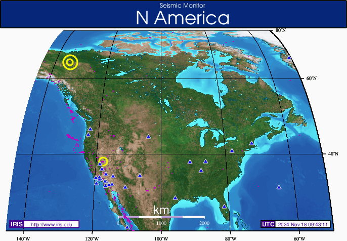
    This is very interesting. Look where these quakes are located... a new pattern is emerging with quakes in New Mexico and Western Texas.

    The Earthquake/Seismic Activity Log - Page 17 ZmMap.eveday.N_America

    Remember what happened before the Virginia quake? There were quakes along same latitude wrapping around to Japan and across the US through Colorado and then Virginia.

    DATE and TIME (UTC) LAT-ITUDE LONG-ITUDE MAG-NITUDE DEPTH km REGION
    13-SEP-2011 05:24:39 36.94 -104.76 4.0 5.0 ````NEW MEXICO
    11-SEP-2011 12:27:45 32.87 -100.80 4.4 10.3 WESTERN TEXAS
    10-SEP-2011 22:07:29 28.42 -112.01 4.6 10.0 GULF OF CALIFORNIA
    10-SEP-2011 09:18:49 28.31 -112.14 4.4 10.4 GULF OF CALIFORNIA
    10-SEP-2011 08:42:51 28.13 -112.25 4.0 12.0 GULF OF CALIFORNIA
    02-SEP-2011 11:03:25 38.07 -112.06 4.7 9.8 UTAH

    Why New Mexico and Western Texas?


    _________________
    What is life?
    It is the flash of a firefly in the night, the breath of a buffalo in the wintertime. It is the little shadow which runs across the grass and loses itself in the sunset.

    With deepest respect ~ Aloha & Mahalo, Carol
    HigherLove
    HigherLove


    Posts : 2357
    Join date : 2011-01-27
    Age : 59

    The Earthquake/Seismic Activity Log - Page 17 Empty Re: The Earthquake/Seismic Activity Log

    Post  HigherLove Tue Sep 13, 2011 12:40 pm

    Magnitude
    5.0
    Date-Time
    Tuesday, September 13, 2011 at 16:19:29 UTC
    Tuesday, September 13, 2011 at 07:19:29 PM at epicenter
    Time of Earthquake in other Time Zones
    Location
    34.409°N, 23.704°E
    Depth
    24.2 km (15.0 miles)
    Region
    CRETE, GREECE
    Distances
    125 km (77 miles) SSW of Chania, Crete, Greece
    165 km (102 miles) SW of Iraklion, Crete, Greece
    259 km (160 miles) N of Tobruk (Tubruq), Libya
    396 km (246 miles) S of ATHENS, Greece
    Location Uncertainty
    horizontal +/- 5.6 km (3.5 miles); depth +/- 13.3 km (8.3 miles)
    Parameters
    NST=146, Nph=146, Dmin=146 km, Rmss=1.13 sec, Gp= 58°,
    M-type=body wave magnitude (Mb), Version=6
    Source
    USGS NEIC (WDCS-D)
    Event ID
    us2011qubi
    HigherLove
    HigherLove


    Posts : 2357
    Join date : 2011-01-27
    Age : 59

    The Earthquake/Seismic Activity Log - Page 17 Empty Re: The Earthquake/Seismic Activity Log

    Post  HigherLove Tue Sep 13, 2011 12:42 pm

    2011-09-13 17:27:56.7
    13min ago
    34.53 N 25.30 E 10 2.2 CRETE, GREECE
    2011-09-13 16:53:59.2
    47min ago
    39.14 N 26.15 E 10 2.3 NEAR THE COAST OF WESTERN TURKEY
    2011-09-13 16:19:27.0
    1hr 21min ago
    34.31 N 23.65 E 2 4.7 CRETE, GREECE
    2011-09-13 16:05:36.0
    1hr 35min ago
    43.68 N 12.16 E 9 2.0 CENTRAL ITALY
    2011-09-13 15:37:57.2
    2hr 03min ago
    38.56 N 20.58 E 10 2.9 GREECE
    2011-09-13 15:09:27.0
    2hr 31min ago
    39.38 N 20.23 E 10 2.4 GREECE
    2011-09-13 14:47:43.2
    2hr 53min ago
    51.39 N 16.28 E 10 2.9 POLAND
    2011-09-13 14:39:03.4
    3hr 02min ago
    40.24 N 23.91 E 5 2.0 GREECE
    2011-09-13 14:24:28.9
    3hr 16min ago
    4.67 S 143.94 E 97 4.1 NEW GUINEA, PAPUA NEW GUINEA
    2011-09-13 14:14:34.0
    3hr 26min ago
    38.85 N 142.30 E 63 4.7 NEAR EAST COAST OF HONSHU, JAPAN
    2011-09-13 13:52:36.1
    3hr 48min ago
    38.72 N 40.01 E 11 2.8 EASTERN TURKEY
    2011-09-13 13:06:38.4
    4hr 34min ago
    37.19 N 30.46 E 13 2.7 WESTERN TURKEY
    2011-09-13 12:28:27.0
    5hr 12min ago
    40.31 N 37.89 E 10 2.5 CENTRAL TURKEY
    2011-09-13 11:32:50.1
    6hr 08min ago
    40.20 N 21.90 E 21 2.1 GREECE
    2011-09-13 11:31:19.1
    6hr 10min ago
    35.34 N 33.47 E 2 2.7 CYPRUS REGION
    2011-09-13 11:27:19.7
    6hr 14min ago
    37.54 N 35.64 E 13 2.5 CENTRAL TURKEY
    2011-09-13 11:22:13.1
    6hr 19min ago
    40.16 N 38.71 E 5 2.7 EASTERN TURKEY
    2011-09-13 11:08:47.0
    6hr 32min ago
    37.55 N 35.69 E 7 2.8 CENTRAL TURKEY
    2011-09-13 09:58:01.1
    7hr 43min ago
    37.17 N 22.00 E 10 2.6 SOUTHERN GREECE
    2011-09-13 09:51:41.0
    7hr 49min ago
    36.16 N 37.08 E 10 3.0 TURKEY-SYRIA BORDER REGION
    2011-09-13 09:50:04.0
    7hr 51min ago
    39.48 N 29.77 W 5 3.2 AZORES ISLANDS, PORTUGAL
    2011-09-13 09:39:33.6
    8hr 01min ago
    39.24 N 23.51 E 10 2.1 AEGEAN SEA
    2011-09-13 09:26:14.8
    8hr 15min ago
    35.75 N 36.28 E 16 2.7 SYRIA
    2011-09-13 09:22:13.4
    8hr 19min ago
    38.78 N 23.37 E 10 2.2 GREECE
    2011-09-13 09:13:17.4
    8hr 28min ago
    38.75 N 23.40 E 10 2.5 GREECE
    2011-09-13 09:10:17.0
    8hr 31min ago
    35.26 N 141.33 E 10 5.0 NEAR EAST COAST OF HONSHU, JAPAN
    2011-09-13 09:08:34.0
    8hr 32min ago
    38.74 N 23.42 E 10 2.7 GREECE
    2011-09-13 08:33:22.8
    9hr 08min ago
    40.03 N 31.64 E 26 2.5 WESTERN TURKEY
    2011-09-13 08:33:10.0
    9hr 08min ago
    39.50 N 29.82 W 5 3.1 AZORES ISLANDS, PORTUGAL
    2011-09-13 08:27:36.0
    9hr 13min ago
    6.93 S 143.96 E 10 4.8 NEW GUINEA, PAPUA NEW GUINEA
    2011-09-13 08:12:50.0
    9hr 28min ago
    39.43 N 35.34 E 5 2.6 CENTRAL TURKEY
    2011-09-13 07:56:08.0
    9hr 45min ago
    6.90 S 144.04 E 10 5.2 NEW GUINEA, PAPUA NEW GUINEA
    2011-09-13 07:45:20.6
    9hr 56min ago
    39.42 N 29.15 E 17 2.6 WESTERN TURKEY
    2011-09-13 07:39:23.3
    10hr 02min ago
    35.57 N 22.61 E 121 3.6 CENTRAL MEDITERRANEAN SEA
    2011-09-13 07:35:58.0
    10hr 05min ago
    39.60 N 29.70 W 10 3.0 AZORES ISLANDS, PORTUGAL
    2011-09-13 07:27:38.9
    10hr 13min ago
    52.89 N 160.51 E 33 4.1 OFF EAST COAST OF KAMCHATKA
    2011-09-13 07:23:03.3
    10hr 18min ago
    38.87 N 27.08 E 10 2.6 WESTERN TURKEY
    2011-09-13 07:20:23.0
    10hr 21min ago
    35.88 N 31.39 E 10 3.2 CYPRUS REGION
    2011-09-13 07:03:55.1
    10hr 37min ago
    38.73 N 23.39 E 10 2.5 GREECE
    2011-09-13 05:53:27.2
    11hr 47min ago
    36.63 N 28.58 E 35 2.7 DODECANESE ISLANDS, GREECE
    2011-09-13 05:43:56.2
    11hr 57min ago
    40.02 N 27.41 E 8 2.8 WESTERN TURKEY
    2011-09-13 05:05:17.0 39.17 N 29.09 E 6 2.1 WESTERN TURKEY
    2011-09-13 05:05:05.6 27.74 N 58.06 E 10 3.6 SOUTHEASTERN IRAN
    2011-09-13 04:54:19.9 36.76 N 22.18 E 5 2.0 SOUTHERN GREECE
    2011-09-13 04:49:35.0 5.69 N 77.51 W 10 5.2 NEAR WEST COAST OF COLOMBIA
    2011-09-13 04:39:41.7 38.83 N 40.11 E 23 2.7 EASTERN TURKEY
    2011-09-13 04:38:51.0 5.67 N 77.52 W 30 5.1 NEAR WEST COAST OF COLOMBIA
    2011-09-13 04:33:43.0 38.58 N 21.28 E 10 2.3 GREECE
    2011-09-13 04:28:11.0 39.25 N 29.98 W 5 3.1 AZORES ISLANDS, PORTUGAL
    2011-09-13 04:04:02.3 37.68 N 29.26 E 5 2.7 WESTERN TURKEY
    HigherLove
    HigherLove


    Posts : 2357
    Join date : 2011-01-27
    Age : 59

    The Earthquake/Seismic Activity Log - Page 17 Empty Re: The Earthquake/Seismic Activity Log

    Post  HigherLove Tue Sep 13, 2011 6:26 pm

    Magnitude
    3.0
    Date-Time
    Tuesday, September 13, 2011 at 22:59:23 UTC
    Tuesday, September 13, 2011 at 05:59:23 PM at epicenter
    Location
    33.591°N, 86.672°W
    Depth
    5 km (3.1 miles)
    Region
    BIRMINGHAM URBAN AREA, ALABAMA
    Distances
    14 km (8 miles) ENE of Birmingham, Alabama
    40 km (24 miles) NNE of Alabaster, Alabama
    62 km (38 miles) ESE of Jasper, Alabama
    140 km (86 miles) NNW of MONTGOMERY, Alabama
    Location Uncertainty
    horizontal +/- 14 km (8.7 miles); depth +/- 2.1 km (1.3 miles)
    Parameters
    NST= 12, Nph= 12, Dmin=69 km, Rmss=0.71 sec, Gp= 94°,
    M-type="Nuttli" surface wave magnitude (mbLg), Version=6
    Source
    Magnitude: USGS NEIC (WDCS-D)
    Location: USGS NEIC (WDCS-D)
    Event ID
    usc0005u19
    HigherLove
    HigherLove


    Posts : 2357
    Join date : 2011-01-27
    Age : 59

    The Earthquake/Seismic Activity Log - Page 17 Empty Re: The Earthquake/Seismic Activity Log

    Post  HigherLove Tue Sep 13, 2011 6:27 pm

    MAP 3.0 2011/09/13 22:59:23 33.591 -86.672 5.0 5 km ( 3 mi) S of Center Point, AL

    Magnitude
    3.0
    Date-Time
    Tuesday, September 13, 2011 at 22:59:23 UTC
    Tuesday, September 13, 2011 at 05:59:23 PM at epicenter
    Location
    33.591°N, 86.672°W
    Depth
    5 km (3.1 miles)
    Region
    BIRMINGHAM URBAN AREA, ALABAMA
    Distances
    14 km (8 miles) ENE of Birmingham, Alabama
    40 km (24 miles) NNE of Alabaster, Alabama
    62 km (38 miles) ESE of Jasper, Alabama
    140 km (86 miles) NNW of MONTGOMERY, Alabama
    Location Uncertainty
    horizontal +/- 14 km (8.7 miles); depth +/- 2.1 km (1.3 miles)
    Parameters
    NST= 12, Nph= 12, Dmin=69 km, Rmss=0.71 sec, Gp= 94°,
    M-type="Nuttli" surface wave magnitude (mbLg), Version=6
    Source
    Magnitude: USGS NEIC (WDCS-D)
    Location: USGS NEIC (WDCS-D)
    Event ID
    usc0005u19


    MAP 3.0 2011/09/13 22:03:44 63.379 -148.951 101.6 3 km ( 2 mi) WSW of Cantwell, AK
    MAP 4.0 2011/09/13 20:18:09 32.105 -115.175 26.7 21 km ( 13 mi) SSW of Guadalupe Victoria, Mexico
    MAP 4.4 2011/09/13 19:59:22 51.222 -175.989 47.5 86 km ( 54 mi) SSE of Adak, AK
    MAP 3.6 2011/09/13 12:27:13 35.730 -121.109 8.0 12 km ( 7 mi) NE of San Simeon, CA
    MAP 3.1 2011/09/13 07:00:53 51.796 -171.508 26.0 191 km (118 mi) ESE of Atka, AK
    MAP 4.0 2011/09/13 05:24:39 36.943 -104.756 5.0 25 km ( 16 mi) SSW of Cokedale, CO
    MAP 3.4 2011/09/13 04:34:05 58.344 -153.920 68.1 67 km ( 42 mi) WNW of Aleneva, AK
    MAP 3.4 2011/09/13 01:37:19 36.976 -104.849 6.8 28 km ( 17 mi) SW of Cokedale, CO
    MAP 3.0 2011/09/12 16:58:25 38.804 -122.805 4.4 1 km ( 0 mi) N of The Geysers, CA
    MAP 3.6 2011/09/12 15:43:40 58.423 -153.164 54.7 43 km ( 27 mi) NNW of Aleneva, AK
    MAP 3.0 2011/09/12 15:35:43 19.559 -66.283 37.8 121 km ( 75 mi) N of Bre�as, PR
    MAP 3.3 2011/09/12 15:35:28 35.629 -97.244 3.4 6 km ( 4 mi) SW of Luther, OK
    MAP 3.4 2011/09/12 14:18:34 32.822 -100.871 7.9 13 km ( 8 mi) NNE of Snyder, TX
    MAP 4.2 2011/09/12 09:37:32 50.781 -129.947 29.4 346 km (215 mi) WNW of Campbell River, Canada
    MAP 3.2 2011/09/12 08:52:22 18.161 -67.891 101.1 70 km ( 44 mi) WSW of Rinc�n, PR


    The Earthquake/Seismic Activity Log - Page 17 Untitl22

    Big Earthquakes in California-Nevada Map Area

    Magnitude 3 and greater earthquakes catalogued in the last week (168 hours) for the California-Nevada map area. Some early events may be obscured by more recent events on the maps. The top three magnitude categories above magnitude 3 (for example 3,4,5 or 4,5,6 or 5,6,7) are in red in the list below.

    The most recent earthquakes are at the top of the list. Times are local (PST or PDT). Click on the word "map" to see a map displaying the earthquake. Click on an event's location to get additional information.

    Update time = Tue, 13 Sep 2011 23:34:13 UTC

    3 earthquakes in list

    Mag Date
    y/m/d Local Time
    hⓂs Latitude
    deg Longitude
    deg Depth
    km Location

    MAP 4.0 2011/09/13 13:18:09 32.105N 115.175W 26.7 21 KM (13 MI) SSW OF GUADALUPE VICTORIA, BAJA CALIFORNIA, MEXICO

    MAP 3.6 2011/09/13 05:27:13 35.730N 121.109W 8.0 12 KM ( 7 MI) NE OF SAN SIMEON, CA

    MAP 3.0 2011/09/12 09:58:25 38.804N 122.805W 4.4 1 KM ( 0 MI) N OF THE GEYSERS, CA


    www.usgs.gov

    ________________________________________-

    HigherLove wrote:
    metaw3 wrote:

    http://www.themistsofavalon.net/t2511p255-here-comes-elenin#55625


    Beautiful PDF here :
    http://www.sonoma.edu/users/v/vegalu/188.pdf

    There seems to be a pattern predicting a California quake Sep 15th.


    To overstate the obvious, I do not like this. Especially when it is published by the university where I was an undergraduate and took coursework on earthquakes, mountains, and volcanoes. :op


    hehehe?

    Time to get out my cards and get the galaxy spinning.

    As Arcturus is my witness...HANDS OFF OF CALIFORNIA!

    No

    http://www.themistsofavalon.net/t3152-destination-arcturas
    HigherLove
    HigherLove


    Posts : 2357
    Join date : 2011-01-27
    Age : 59

    The Earthquake/Seismic Activity Log - Page 17 Empty Re: The Earthquake/Seismic Activity Log

    Post  HigherLove Wed Sep 14, 2011 12:51 am

    2.7 S/SE Illinois
    HigherLove
    HigherLove


    Posts : 2357
    Join date : 2011-01-27
    Age : 59

    The Earthquake/Seismic Activity Log - Page 17 Empty Re: The Earthquake/Seismic Activity Log

    Post  HigherLove Wed Sep 14, 2011 12:53 am

    On September 13, 2011 at 09:29:28 AM a weak tremor of 2.6 magnitude occurred below the crater of Mt Rainier, the Washington volcano.

    http://earthquake-report.com/2011/09/13/weak-earthquake-right-below-mount-rainier-volcano-washington-usa/
    HigherLove
    HigherLove


    Posts : 2357
    Join date : 2011-01-27
    Age : 59

    The Earthquake/Seismic Activity Log - Page 17 Empty Re: The Earthquake/Seismic Activity Log

    Post  HigherLove Wed Sep 14, 2011 9:49 am

    Magnitude
    4.2
    Date-Time
    Wednesday, September 14, 2011 at 14:44:50 UTC
    Wednesday, September 14, 2011 at 07:44:50 AM at epicenter
    Location
    33.957°N, 117.070°W
    Depth
    15.6 km (9.7 miles)
    Region
    GREATER LOS ANGELES AREA, CALIFORNIA
    Distances
    8 km (5 miles) SSW (193°) from Yucaipa, CA
    10 km (6 miles) WNW (293°) from Beaumont, CA
    13 km (8 miles) SSE (159°) from Mentone, CA
    15 km (9 miles) ENE (77°) from Moreno Valley, CA
    109 km (68 miles) E (95°) from Los Angeles Civic Center, CA
    Location Uncertainty
    horizontal +/- 0.3 km (0.2 miles); depth +/- 0.6 km (0.4 miles)
    Parameters
    Nph=150, Dmin=9 km, Rmss=0.38 sec, Gp= 32°,
    M-type=local magnitude (ML), Version=0
    Source
    California Integrated Seismic Net:
    USGS Caltech CGS UCB UCSD UNR
    Event ID
    ci11006189
    mudra
    mudra


    Posts : 23307
    Join date : 2010-04-09
    Age : 70
    Location : belgium

    The Earthquake/Seismic Activity Log - Page 17 Empty Re: The Earthquake/Seismic Activity Log

    Post  mudra Thu Sep 15, 2011 2:56 pm

    September 15th 2011

    A very strong earthquake hits Fiji region with a magnitude of 7.2 on Richter scale.

    Love Always
    mudra
    HigherLove
    HigherLove


    Posts : 2357
    Join date : 2011-01-27
    Age : 59

    The Earthquake/Seismic Activity Log - Page 17 Empty Re: The Earthquake/Seismic Activity Log

    Post  HigherLove Thu Sep 15, 2011 3:13 pm

    mudra wrote:September 15th 2011

    A very strong earthquake hits Fiji region with a magnitude of 7.2 on Richter scale.

    Love Always
    mudra

    Thanks, mudra! I stepped away for 30 minutes...

    There has to be a way to deflect quakes from one place without them popping up in another...hmmm

    Magnitude
    7.2
    Date-Time
    Thursday, September 15, 2011 at 19:30:59 UTC

    Earthquakes list September 15, 2011 – California + China + Japan + Fiji (Tonga)
    NOT DANGEROUS

    M 7.2 2011/09/15 19:30 Depth 593.0 km FIJI REGION (Tonga)
    Friday, September 16, 2011 at 07:30:59 AM at epicenter
    Harmless DEEP earthquake with its hypocenter in the solid hot mantle of the earth
    This earthquake will probably be felt as a very weak shaking in a big radius (hundreds of km)
    There is NO risk for a tsunami

    http://earthquake-report.com/2011/09/14/earthquakes-list-september-15-2011/


    Friday, September 16, 2011 at 07:30:59 AM at epicenter
    Time of Earthquake in other Time Zones
    Location
    21.596°S, 179.270°W
    Depth
    593 km (368.5 miles)
    Region
    FIJI REGION
    Distances
    120 km (74 miles) SSW of Ndoi Island, Fiji
    425 km (264 miles) W of NUKU`ALOFA, Tonga
    453 km (281 miles) SSE of SUVA, Viti Levu, Fiji
    1788 km (1111 miles) NNE of Auckland, New Zealand
    Location Uncertainty
    horizontal +/- 17.2 km (10.7 miles); depth +/- 18.7 km (11.6 miles)
    Parameters
    NST= 49, Nph= 49, Dmin=511 km, Rmss=0.85 sec, Gp= 79°,
    M-type=regional moment magnitude (Mw), Version=6
    Source
    Magnitude: USGS NEIC (WDCS-D)
    Location: USGS NEIC (WDCS-D)
    Event ID
    usc0005vcv


    MAP 3.5 2011/09/15 19:38:28 20.171 -155.486 28.4 HAWAII REGION, HAWAII
    MAP 7.2 2011/09/15 19:30:59 -21.596 -179.270 593.0 FIJI REGION
    MAP 3.0 2011/09/15 18:29:56 59.675 -150.678 32.8 KENAI PENINSULA, ALASKA
    MAP 2.5 2011/09/15 16:44:34 51.829 -174.413 63.0 ANDREANOF ISLANDS, ALEUTIAN IS., ALASKA
    MAP 5.1 2011/09/15 16:08:33 -54.041 -1.971 16.3 BOUVET ISLAND REGION
    MAP 5.1 2011/09/15 15:27:02 36.383 82.528 6.5 SOUTHERN XINJIANG, CHINA
    MAP 3.2 2011/09/15 15:06:00 19.332 -155.177 9.3 ISLAND OF HAWAII, HAWAII
    MAP 4.7 2011/09/15 14:25:09 39.826 141.996 35.0 EASTERN HONSHU, JAPAN
    MAP 3.5 2011/09/15 12:16:23 63.263 -151.442 11.5 CENTRAL ALASKA
    MAP 5.5 2011/09/15 11:59:53 -14.848 -177.812 370.0 FIJI REGION
    MAP 2.6 2011/09/15 11:07:05 32.066 -115.120 10.0 BAJA CALIFORNIA, MEXICO
    MAP 4.1 2011/09/15 11:02:14 49.573 -127.182 25.2 VANCOUVER ISLAND, CANADA REGION
    MAP 4.9 2011/09/15 10:46:28 3.363 126.662 19.1 KEPULAUAN TALAUD, INDONESIA
    MAP 2.6 2011/09/15 10:41:41 17.680 -67.479 5.0 PUERTO RICO REGION
    MAP 2.8 2011/09/15 10:15:13 18.202 -67.101 32.5 PUERTO RICO
    MAP 3.5 2011/09/15 09:56:42 33.633 -117.839 10.6 GREATER LOS ANGELES AREA, CALIFORNIA
    MAP 5.1 2011/09/15 08:43:07 19.563 -78.008 5.0 CUBA REGION
    MAP 4.4 2011/09/15 08:42:25 35.819 25.640 41.6 CRETE, GREECE
    MAP 6.2 2011/09/15 08:00:07 36.289 141.308 10.0 NEAR THE EAST COAST OF HONSHU, JAPAN
    MAP 6.0 2011/09/15 07:53:12 -35.430 -177.878 13.4 EAST OF THE NORTH ISLAND, NEW ZEALAND
    MAP 2.8 2011/09/15 04:35:13 32.186 -115.258 10.0 BAJA CALIFORNIA, MEXICO
    MAP 4.4 2011/09/15 03:44:04 21.627 143.005 294.0 MARIANA ISLANDS REGION
    MAP 4.5 2011/09/15 02:06:49 59.132 -138.121 7.3 SOUTHEASTERN ALASKA
    MAP 4.1 2011/09/15 00:21:05 59.902 -151.823 53.7 KENAI PENINSULA, ALASKA

    The Earthquake/Seismic Activity Log - Page 17 Untitl23

      Current date/time is Mon Nov 18, 2024 10:31 pm