tMoA

Would you like to react to this message? Create an account in a few clicks or log in to continue.
tMoA

~ The only Home on the Web You'll ever need ~

+21
Aquaries1111
giovonni
arvan33
Floyd
lawlessline
JesterTerrestrial
THEeXchanger
newel
Brook
greybeard
Mercuriel
Sanicle
devakas
hobbit
mudra
burgundia
lindabaker
LeeEllisMusic
MargueriteBee
Carol
HigherLove
25 posters

    The Earthquake/Seismic Activity Log

    HigherLove
    HigherLove


    Posts : 2357
    Join date : 2011-01-27
    Age : 59

    The Earthquake/Seismic Activity Log - Page 18 Empty Re: The Earthquake/Seismic Activity Log

    Post  HigherLove Thu Sep 15, 2011 3:20 pm

    Magnitude
    3.5
    Date-Time
    Thursday, September 15, 2011 at 09:56:41 UTC
    Thursday, September 15, 2011 at 02:56:41 AM at epicenter
    Time of Earthquake in other Time Zones
    Location
    33.633°N, 117.839°W
    Depth
    10.6 km (6.6 miles)
    Region
    GREATER LOS ANGELES AREA, CALIFORNIA
    Distances
    2 km (1 miles) N (355°) from San Joaquin Hills, CA
    4 km (2 miles) NNW (344°) from Newport Coast, CA
    6 km (4 miles) ENE (72°) from Newport Beach, CA
    7 km (4 miles) SW (217°) from Irvine, CA
    13 km (8 miles) SSE (162°) from Santa Ana, CA
    60 km (37 miles) SE (141°) from Los Angeles Civic Center, CA
    Location Uncertainty
    horizontal +/- 0.3 km (0.2 miles); depth +/- 0.4 km (0.2 miles)
    Parameters
    Nph=110, Dmin=5 km, Rmss=0.24 sec, Gp= 83°,
    M-type=local magnitude (ML), Version=7
    Source
    California Integrated Seismic Net:
    USGS Caltech CGS UCB UCSD UNR
    Event ID
    ci11006789
    mudra
    mudra


    Posts : 23307
    Join date : 2010-04-09
    Age : 70
    Location : belgium

    The Earthquake/Seismic Activity Log - Page 18 Empty Re: The Earthquake/Seismic Activity Log

    Post  mudra Thu Sep 15, 2011 4:22 pm

    9/15/2011 -- 7.3M earthquake in Fiji - North of New Zealand = 14th large quake within 14 days

    https://www.youtube.com/watch?v=k8P-nPO6BuE


    Love Always
    mudra
    Carol
    Carol
    Admin
    Admin


    Posts : 32911
    Join date : 2010-04-07
    Location : Hawaii

    The Earthquake/Seismic Activity Log - Page 18 Empty Re: The Earthquake/Seismic Activity Log

    Post  Carol Fri Sep 16, 2011 6:34 pm

    The Earthquake/Seismic Activity Log - Page 18 Japan-d
    6.2 and 6.6 magnitude earthquake strikes off the coast of Japan
    September 16, 2011- JAPAN – This map shows the latest breakout of earthquakes and reveals the amount of seismic stress being unleashed off the coast of the Japanese mainland. The 6.2 magnitude earthquake is the 16th major (6.0 +) earthquake to strike in the month of September. –The Extinction Protocol

    TOKYO — A strong 6.6-magnitude undersea quake and a series of aftershocks hit off the coast of Japan’s Honshu island Saturday, not far from the area ravaged by a huge March quake and tsunami, geologists said. There were no immediate reports of damage or casualties and no widespread tsunami warning, although the initial earthquake was followed by four more quakes, one of them coming in at magnitude 6.2. The United States Geological Survey (USGS) said the first, 36.2-kilometre (22.6-mile) deep quake hit 108 kilometres east-south-east of the coastal town of Hachinohe, 574 kilometres from Tokyo, at 4:26 am (1926 GMT Friday). The Pacific Tsunami Warning Center said that “no destructive widespread tsunami risk exists based on historical earthquake and tsunami data.” But it said that quakes of this size sometimes generate local tsunamis. “Authorities in the region of the epicentre should be aware of this,” the centre said in a statement. The Japan Meteorological Agency said that there might be some changes in sea levels due to the first earthquake, but that there were no reports of damage or casualties and none were expected, according to the Kyodo news agency. It said the initial quake jolted Iwate prefecture, an area badly hit by the 9.0-magnitude earthquake and tsunami on March 11 that left almost 20,000 dead or missing and sparked the worst nuclear crisis since Chernobyl. The 6.6-magnitude quake was followed by a smaller, 5.2-magnitude tremor, 10.4 kilometres deep and 46 kilometres from Hachinohe at 4:39 am (1939 GMT Friday), then a third, 5.5-magnitude quake at 6:11 am (2011 GMT Friday), this time at a depth of 19 kilometres, 144 kilometres from Hachinohe. The fourth quake struck at 7:08 am (2108 GMT Friday), with a magnitude of 6.2 at a depth of 20.2 kilometres, 137 kilometres east-south-east of Hachinohe. Again, no widespread tsunami warning was issued. At 07:36 (2136 GMT), a 5.6-magnitude quake hit at a depth of 17.6 kilometres, 161 kilometres east-south-east of Hachinohe, USGS said. Japan, located on the tectonic crossroads known as the “Pacific Ring of Fire” and dotted with volcanoes, is one of the world’s most quake-prone countries. -AFP
    http://theextinctionprotocol.wordpress.com/2011/09/16/6-2-magnitude-earthquake-strikes-off-the-coast-of-japan/


    _________________
    What is life?
    It is the flash of a firefly in the night, the breath of a buffalo in the wintertime. It is the little shadow which runs across the grass and loses itself in the sunset.

    With deepest respect ~ Aloha & Mahalo, Carol
    HigherLove
    HigherLove


    Posts : 2357
    Join date : 2011-01-27
    Age : 59

    The Earthquake/Seismic Activity Log - Page 18 Empty Re: The Earthquake/Seismic Activity Log

    Post  HigherLove Sun Sep 18, 2011 9:20 am

    Magnitude
    6.8
    Date-Time
    Sunday, September 18, 2011 at 12:40:48 UTC
    Sunday, September 18, 2011 at 06:10:48 PM at epicenter
    Time of Earthquake in other Time Zones
    Location
    27.730°N, 88.082°E
    Depth
    20.7 km (12.9 miles)
    Region
    SIKKIM, INDIA
    Distances
    68 km (42 miles) NW of Gangtok, Sikkim, India
    119 km (73 miles) NNW of Shiliguri, West Bengal, India
    272 km (169 miles) E of KATHMANDU, Nepal
    572 km (355 miles) N of Kolkata (Calcutta), West Bengal, India
    Location Uncertainty
    horizontal +/- 14.4 km (8.9 miles); depth +/- 7.4 km (4.6 miles)
    Parameters
    NST=258, Nph=258, Dmin=369.6 km, Rmss=1.17 sec, Gp= 29°,
    M-type=regional moment magnitude (Mw), Version=9
    Source
    Magnitude: USGS NEIC (WDCS-D)
    Location: USGS NEIC (WDCS-D)
    Event ID
    usc0005wg6


    Earthquake overview : A magnitude 6.8 earthquake hit India 12:40:48 UT (10:48 PM at epicenter) The depth of the hypocenter was at 20.7 km.

    The quake comes just days after an earthquake of 4.2 magnitude hit Haryana's Sonepat district, sending tremors in New Delhi.

    "I have Felt it" Reports –> see below + Let us know how you have felt this earthquake

    To read the full story as it happened, we advise our readers to start at the lower part of the page (earthquake data).
    We are currently collecting data from this earthquake

    UPDATE: 14:13 UTC:-
    Aftershocks of 6.1 and 5.3 have occurred. Regional TV station NewsLive reported that 10 to 12 buildings collapsed in Sikkim's state capital of Gangtok. We expect further damage and fatalities close to the epicentre.

    UPDATE: 14:11 UTC:-
    From Earthquake-report.com reporter Szombath Balazs: Reports say BSNL lines in north Bengal are down cutting off communication links in the region. Power has been disrupted in Darjeeling and other northern parts of West Bengal. In Assam's major city Guwahati, people panicked and ran out on the streets after the quake shook their houses. There were initial reports of minor damage.
    UPDATE: 14:07 UTC:-
    The first damage reports have come in with Indian reports detailing at least a dozen houses have collapsed in Sikkim alone.

    Many houses collapsing may have caused many injured. More damage reports are expected soon.

    This earthquake has been labelled CATDAT Orange, and is expected to move up to CATDAT Red soon.

    UPDATE: 14:00 UTC:-
    Just repeating, that a major earthquake has occurred on the India/Nepal border – Mw6.8. The earthquake occurred on a strike-slip fault from the moment tensor solution.

    From GFZ – Mw6.8, 27.7N, 88.17E, 30km depth.

    From USGS – Mw6.8, 27.73N, 88.082N, 20.7km depth.

    This earthquake has been felt up to 900km away according to some felt reports. The closest felt report from USGS at the moment is 70km away at intensity 6 or 7.

    http://earthquake-report.com/2011/09/18/very-strong-earthquake-in-sikkim-india/

    The Earthquake/Seismic Activity Log - Page 18 Untitl11
    Carol
    Carol
    Admin
    Admin


    Posts : 32911
    Join date : 2010-04-07
    Location : Hawaii

    The Earthquake/Seismic Activity Log - Page 18 Empty Re: The Earthquake/Seismic Activity Log

    Post  Carol Sun Sep 18, 2011 9:54 am

    The Earthquake/Seismic Activity Log - Page 18 India
    September 18, 2011 – INDIA – A 6.8 magnitude earthquake struck the region of northern India near Sikkim. The quake had a depth of 20 km and was immediately followed by a 4.8 magnitude aftershock at relatively the same depth. The epicenter of the earthquake was 119 km (73 miles) NNW of Shiliguri, West Bengal, India and 572 km (355 miles) N of Kolkata (Calcutta), West Bengal, India. The earthquake struck in the mountainous region of India Sunday evening and there were no immediate reports of damage. The 6.8 magnitude is the 17th major earthquake to strike the planet in the month of September.


    Seismic activity: Indian scientists investigate unusual changes to the sea near Kerala

    September 17, 2011 – INDIA - With a foul smell emanating from the sea in some parts of Kerala in the last few days, scientists have said there was no cause for anxiety but are divided on the reasons behind the phenomenon. Some scientists have attributed this to the large mass of marine algae killed by lowering of salinity owing to influx of fresh water from rivers and run-off but another state-based researcher disagrees with it and said the phenomenon was due to seismic factors. A team of researchers from Kerala University, which studied the phenomenon reported from coastal areas off Kollam and Thiruvananthapuram had held the foul smell was attributable to the bacterial decay of a possible algal bloom. They said they reached the conclusion based on examination of various parameters like the colour of the sea, salinity, temperature, pH nutrients, plankton, microbes and fish mortality. However, Dr. Sainudeen Pattazhy, Associate Professor of Zoology in SN College Kollam, said the stench was linked to seismic phenomena like tremors of moderate intensity that had been experienced in several districts of Kerala and other states recently. Even though parameters like salinity and temperature were within the optimum levels, there was no chance of occurrence of algal blooming, massive death and decay of algae. If algal blooming occurred, a thick scum would develop on the sea surface, which had not happened, Dr. Pattazhy told PTI. Anoxic conditions during the night, changes in water quality, pollution, upwelling, nutrient discharges, run-off from the land during the south west monsoon were all natural process but no foul smell had been felt, Dr Pattazhy said. “If massive death of plankton was due to lowering of salinity, then why did it not affect the fish fauna and other animals? No mortality of fish and other animals were observed during this period,” Dr. Pattazhy, also president of Kerala Environmental Researchers Association, said. Stench event and “red rain” were observed in 2000, 2001 and 2011 in Kerala. These events were preceded by low intensity tremors in several districts of Kerala, massive collapse of wells and land slips, he said. The fundamental cause of stench from sea was attributable to geological changes under sea, he said. The December 12, 2000 quake and the lesser intensive tremors that occurred in 2001 were causing several perceivable changes in the earth as well as the atmosphere. The epicentre was stated to be in Meenachil Taluk in Kottayam district, he said. When ‘fault’ occurred under sea, hydrogen sulphide and other inert gases would escape from the sea surface, which was the reason for the foul smell and this had no connection with algal blooming, salinity and nutrient variations, he said. At times, following the emission of gases from under the sea, molten lava would ooze to the sea surface. Some fisherman had recently reported that they had seen oozing of black fluid from the bottom to the surface of sea, he said. –The Hindu


    _________________
    What is life?
    It is the flash of a firefly in the night, the breath of a buffalo in the wintertime. It is the little shadow which runs across the grass and loses itself in the sunset.

    With deepest respect ~ Aloha & Mahalo, Carol
    HigherLove
    HigherLove


    Posts : 2357
    Join date : 2011-01-27
    Age : 59

    The Earthquake/Seismic Activity Log - Page 18 Empty Re: The Earthquake/Seismic Activity Log

    Post  HigherLove Sun Sep 18, 2011 11:35 am

    Carol wrote:


    Seismic activity: Indian scientists investigate unusual changes to the sea near Kerala
    Stench event and “red rain” were observed in 2000, 2001 and 2011 in Kerala. These events were preceded by low intensity tremors in several districts of Kerala, massive collapse of wells and land slips, he said.


    Ancient Aliens explored phenomenon such a red rain in relation to epidemics/pandemics.

    Ancient Aliens, Season 3, Ep 7! "Aliens, Plagues and Epidemics" Scientists are continually challenged by unidentified strains of bacteria with mysterious origins. Could some of our most crippling plagues and epidemics be traced to the darkest voids of space, or perhaps even extraterrestrial intervention? THIS show will FREAK. YOU. OUT! Please tell EVERYONE to tune in! Oh, and don't watch this one alone... History Ch. Check YOUR local listings. This show IS on tonight, Thurs, Sept 8. --Tsoukalos
    Carol
    Carol
    Admin
    Admin


    Posts : 32911
    Join date : 2010-04-07
    Location : Hawaii

    The Earthquake/Seismic Activity Log - Page 18 Empty Re: The Earthquake/Seismic Activity Log

    Post  Carol Mon Sep 19, 2011 5:00 pm

    The Earthquake/Seismic Activity Log - Page 18 R-GUATEMALA-EARTHQUAKE-large570
    Guatemala Earthquake 2011: Tremors Shake Central American Country
    http://www.huffingtonpost.com/2011/09/19/guatemala-earthquake-2011_n_970387.html
    The epicenter of the magnitude 5.8 quake was 32 miles southeast of Guatemala City, the country's capital
    Magnitude 4.8 - GUATEMALA
    According to Reuters, one of the victims -- in Cuilapa, Santa Rosa -- died in a landslide triggered by the earthquake. It is not yet clear how the other two reported fatalities occurred. The U.S. Geological Survey (USGS) reports that a quake with a magnitude of 5.8 hit at 12:34:00 p.m. local time, or 2:34 p.m. EDT. Weaker earthquakes -- both measuring a magnitude of 4.8 -- struck about a half hour before and about 45 minutes after the larger tremor.


    _________________
    What is life?
    It is the flash of a firefly in the night, the breath of a buffalo in the wintertime. It is the little shadow which runs across the grass and loses itself in the sunset.

    With deepest respect ~ Aloha & Mahalo, Carol
    Carol
    Carol
    Admin
    Admin


    Posts : 32911
    Join date : 2010-04-07
    Location : Hawaii

    The Earthquake/Seismic Activity Log - Page 18 Empty Re: The Earthquake/Seismic Activity Log

    Post  Carol Wed Sep 21, 2011 4:54 pm

    https://www.youtube.com/watch?feature=player_embedded&v=PKgtHMw1huw
    Orion Alignment Earthquake September 20 2011
    Excellent!


    The real deal - not Elenin but PX = his take, pole shift.

    The situation is this: Comet Elenin is just one of many asteroid like objects that surround Nibiru and they on their own pose a real threat to us on Earth in the form of impacts.

    However it is Nibiru, Planet X, the planet of the crossing which likely isn't a planet at all but in fact a brown dwarf star, a so called failed star shrouded in cold black debris.

    The Earthquake Tides and Alignments charts can be viewed here
    http://blacksun2012.com/earthquakes-tides-alignments/

    Video describing the Earthquakes Tides and Alignments charts
    https://www.youtube.com/watch?v=5J50Q0qs35Y

    First video describing the clock experiment
    https://www.youtube.com/watch?v=PspU-D__Wfw

    Video taken with a standard camera phone on 14th September 2011 in North Wales
    https://www.youtube.com/watch?v=8UtEO0J3nRs

    Images missing on Stereo A Sept 19
    https://www.youtube.com/watch?v=q2yAhieS8_4

    Multiptiple objects traveling with Elenin
    https://www.youtube.com/watch?v=378n-oHfm1E
    http://6888comete.free.fr/fr/imageC2010X1eleninfrance.htm

    Youtube channel illdivvies47
    https://www.youtube.com/user/illdivvies47

    Denver New World Airport Murals
    http://extraordinaryintelligence.com/970/the-unexplained/mysterious-murals-an...

    Wings Over the Rockies Air and Space Museum in Denver
    In a keystone event, the Wings Museum will host an International Space Station Science and Research Expo
    Sept 21 through Sept 27, astronauts, engineers, education specialists and program scientists will make presentations.
    http://www.sacbee.com/2011/09/06/3888959/nasa-lands-in-colorado-with-internat...

    Obama To Visit Denver Area On Sept 27 - CBS Denver
    http://denver.cbslocal.com/2011/08/31/obama-to-visit-denver-area-on-sept-27/

    Live Internet Seismic Server
    http://aslwww.cr.usgs.gov/Seismic_Data/heli2.shtml

    Latest Earthquakes in the World - Past 7 days
    http://earthquake.usgs.gov/earthquakes/recenteqsww/Quakes/quakes_all.php


    _________________
    What is life?
    It is the flash of a firefly in the night, the breath of a buffalo in the wintertime. It is the little shadow which runs across the grass and loses itself in the sunset.

    With deepest respect ~ Aloha & Mahalo, Carol
    Carol
    Carol
    Admin
    Admin


    Posts : 32911
    Join date : 2010-04-07
    Location : Hawaii

    The Earthquake/Seismic Activity Log - Page 18 Empty Re: The Earthquake/Seismic Activity Log

    Post  Carol Thu Sep 22, 2011 9:18 pm

    6.8M earthquake TONGA samoa islands

    The Earthquake/Seismic Activity Log - Page 18 236635.global.thumb


    _________________
    What is life?
    It is the flash of a firefly in the night, the breath of a buffalo in the wintertime. It is the little shadow which runs across the grass and loses itself in the sunset.

    With deepest respect ~ Aloha & Mahalo, Carol
    mudra
    mudra


    Posts : 23307
    Join date : 2010-04-09
    Age : 70
    Location : belgium

    The Earthquake/Seismic Activity Log - Page 18 Empty Re: The Earthquake/Seismic Activity Log

    Post  mudra Sat Sep 24, 2011 8:07 am

    Prof. Sergey Pulinets: Are Earthquakes Foreseeable?

    https://www.youtube.com/watch?v=YYrX09xNrLA


    Love Always
    mudra
    HigherLove
    HigherLove


    Posts : 2357
    Join date : 2011-01-27
    Age : 59

    The Earthquake/Seismic Activity Log - Page 18 Empty Re: The Earthquake/Seismic Activity Log

    Post  HigherLove Sun Sep 25, 2011 9:18 am

    I missed this one -

    Magnitude
    3.6
    Date-Time
    Thursday, September 22, 2011 at 23:32:09 UTC
    Thursday, September 22, 2011 at 06:32:09 PM at epicenter
    Time of Earthquake in other Time Zones
    Location
    36.818°N, 90.749°W
    Depth
    11.5 km (7.1 miles)
    Region
    SOUTHEASTERN MISSOURI
    Distances
    7 km (4 miles) E (101°) from Grandin, MO
    13 km (8 miles) S (181°) from Ellsinore, MO
    23 km (14 miles) NNE (17°) from Doniphan, MO
    202 km (125 miles) NNW (340°) from Memphis, TN
    206 km (128 miles) SSW (193°) from St. Louis, MO
    Location Uncertainty
    horizontal +/- 0.6 km (0.4 miles); depth +/- 0.8 km (0.5 miles)
    Parameters
    NST= 37, Nph= 59, Dmin=29 km, Rmss=0.28 sec, Gp= 86°,
    M-type="Nuttli" surface wave magnitude (mbLg), Version=D
    Source
    Cooperative New Madrid Seismic Network
    Event ID
    nm092211b
    HigherLove
    HigherLove


    Posts : 2357
    Join date : 2011-01-27
    Age : 59

    The Earthquake/Seismic Activity Log - Page 18 Empty Re: The Earthquake/Seismic Activity Log

    Post  HigherLove Tue Sep 27, 2011 1:14 pm

    Earthquake-Report.com Google+ page – Join Us

    We have just opened a Google+ account for those people regularly using their Google+ account and wanting to see our daily earthquake news and updates in their Google+ account.

    Everything what we will be publishing in Facebook and Twitter will also be published in this Google+ account .
    Are updates are shared in 'public' as we do not want to build walls around it.

    We will welcome all among you that want to join us as friends.

    If you have friends with a google+ account, living in an earthquake sensitive area or wanting to know what happens on our planet, please ask them to join us. A bigger family generates more discussion and quicker interaction.

    https://plus.google.com/100997849632731016277

    Remark : this post is not meant to convince people to open a Google+ account. Everybody is free to do so if he/she wants. We wanted to be present in the social platform from the very beginning, even if it has no groups or pages yet.

    http://earthquake-report.com/2011/09/26/earthquake-report-com-google-page-join-us/

    The most impressive Image series of the Nepal / Sikkim Himalaya earthquake so far

    http://earthquake-report.com/2011/09/27/the-most-impressive-image-series-of-the-nepal-sikkim-himalaya-earthquake-so-far/

    Nepal / Sikkim Himalaya earthquake – extended September 27 overview – slow rescue due to bad weather

    http://earthquake-report.com/2011/09/27/nepal-sikkim-himalaya-earthquake-extended-september-27-overview-slow-rescue-due-to-weather/

    _______________


    The Earthquake/Seismic Activity Log - Page 18 Untitl25
    HigherLove
    HigherLove


    Posts : 2357
    Join date : 2011-01-27
    Age : 59

    The Earthquake/Seismic Activity Log - Page 18 Empty Re: The Earthquake/Seismic Activity Log

    Post  HigherLove Thu Oct 06, 2011 8:26 am

    Magnitude
    6.2
    Date-Time
    Thursday, October 06, 2011 at 11:12:29 UTC
    Thursday, October 06, 2011 at 08:12:29 AM at epicenter
    Time of Earthquake in other Time Zones
    Location
    24.181°S, 64.250°W
    Depth
    9.5 km (5.9 miles)
    Region
    JUJUY, ARGENTINA
    Distances
    106 km (65 miles) E of San Salvador de Jujuy, Jujuy, Argentina
    129 km (80 miles) N of El Quebrachal, Salta, Argentina
    135 km (83 miles) ENE of Salta, Salta, Argentina
    1274 km (791 miles) NNW of BUENOS AIRES, D.F., Argentina
    Location Uncertainty
    horizontal +/- 15.5 km (9.6 miles); depth +/- 4 km (2.5 miles)
    Parameters
    NST=355, Nph=355, Dmin=507.6 km, Rmss=0.9 sec, Gp= 32°,
    M-type=regional moment magnitude (Mw), Version=6
    Source
    Magnitude: USGS NEIC (WDCS-D)
    Location: USGS NEIC (WDCS-D)
    Event ID
    usc00065dr

    _______________________________________

    Very strong dangerous shallow earthquake in Argentina
    Last update: October 6, 2011 at 1:19 pm by By Armand Vervaeck and James Daniell


    http://earthquake-report.com/2011/10/06/very-dangerous-and-very-strong-shallow-earthquake-in-argentina/


    The Earthquake/Seismic Activity Log - Page 18 Untitl27
    HigherLove
    HigherLove


    Posts : 2357
    Join date : 2011-01-27
    Age : 59

    The Earthquake/Seismic Activity Log - Page 18 Empty Re: The Earthquake/Seismic Activity Log

    Post  HigherLove Thu Oct 06, 2011 11:40 am

    MAP 2.9 2011/10/06 15:58:22 32.105 -115.233 11.2 BAJA CALIFORNIA, MEXICO
    MAP 5.3 2011/10/06 15:26:23 -14.888 167.327 142.9 VANUATU
    MAP 2.9 2011/10/06 15:13:47 59.626 -148.684 0.3 KENAI PENINSULA, ALASKA
    MAP 2.7 2011/10/06 15:08:01 59.321 -152.302 61.6 SOUTHERN ALASKA
    MAP 5.1 2011/10/06 14:56:35 -19.642 -69.067 98.1 TARAPACA, CHILE
    MAP 4.7 2011/10/06 13:59:27 -29.122 -176.944 69.9 KERMADEC ISLANDS REGION
    MAP 3.0 2011/10/06 13:51:07 61.399 -146.764 16.6 SOUTHERN ALASKA
    MAP 6.2 2011/10/06 11:12:29 -24.181 -64.250 9.5 JUJUY, ARGENTINA
    MAP 4.7 2011/10/06 10:37:17 36.379 137.299 29.6 EASTERN HONSHU, JAPAN
    MAP 2.8 2011/10/06 09:26:22 59.155 -153.488 12.3 SOUTHERN ALASKA
    MAP 4.4 2011/10/06 08:38:11 11.575 -87.131 59.8 NEAR THE COAST OF NICARAGUA
    MAP 4.7 2011/10/06 08:37:32 38.248 142.683 31.2 NEAR THE EAST COAST OF HONSHU, JAPAN
    MAP 3.1 2011/10/06 08:37:20 18.854 -67.629 3.1 PUERTO RICO REGION
    MAP 3.1 2011/10/06 07:55:33 18.950 -67.717 14.1 PUERTO RICO REGION
    MAP 5.8 2011/10/06 07:37:04 9.712 138.292 35.7 STATE OF YAP, FED. STATES OF MICRONESIA
    MAP 3.1 2011/10/06 07:12:07 18.499 -67.518 18.1 MONA PASSAGE, PUERTO RICO
    MAP 2.8 2011/10/06 05:14:59 18.913 -67.666 17.3 PUERTO RICO REGION
    MAP 4.2 2011/10/06 05:11:51 16.834 -94.305 88.3 OAXACA, MEXICO
    MAP 3.2 2011/10/06 04:00:48 18.762 -67.397 10.0 PUERTO RICO REGION
    MAP 3.1 2011/10/06 03:11:22 18.168 -68.001 110.0 MONA PASSAGE, DOMINICAN REPUBLIC
    MAP 5.6 2011/10/06 00:39:33 57.884 -32.563 10.2 REYKJANES RIDGE
    MAP 2.8 2011/10/06 00:31:32 32.638 -115.945 7.6 SOUTHERN CALIFORNIA
    MAP 3.2 2011/10/06 00:06:19 57.187 -155.789 63.9 ALASKA PENINSULA
    MAP 5.0 2011/10/06 00:03:04 57.929 -32.363 10.0 REYKJANES RIDGE
    HigherLove
    HigherLove


    Posts : 2357
    Join date : 2011-01-27
    Age : 59

    The Earthquake/Seismic Activity Log - Page 18 Empty Re: The Earthquake/Seismic Activity Log

    Post  HigherLove Thu Oct 06, 2011 11:49 am

    Great web site -

    http://www.irishweatheronline.com/

    Home » News » Earth Science » Geology » Reykjanes Ridge Hit By Three Moderate Earthquakes

    Reykjanes Ridge Hit By Three Moderate Earthquakes

    http://www.irishweatheronline.com/news/earth-science/geology/reykjanes-ridge-hit-by-three-moderate-earthquakes/40924.html

    The Earthquake/Seismic Activity Log - Page 18 Epicen10

    Northern Argentina Hit By Strong, Shallow Earthquake October 6, 2011

    Volcanic Activity Updates For Villarrica, Krakatau, El Hierro, Nabro And Mount Etna October 6, 2011

    600,000 Haiti Earthquake Victims Remain In Camps October 6, 2011

    Chile Launches Disaster Reduction System October 6, 2011

    Chinese Coal Mine Explosion Kills At Least 16 October 6, 2011

    Rare Subsea Earthquakes Rattle Bermuda Region October 4, 2011

    Anak Krakatau (Child Of Krakatoa) Erupts October 4, 2011

    Earthquake Swarm Continues On El Hierro, Canary Islands October 4, 2011

    4.8 Magnitude Earthquake Hits Romania October 4, 2011

    How Earthquakes Are Measured Around The World October 3, 2011

    The Earthquake/Seismic Activity Log - Page 18 Untitl28

    ______________________

    Added at 12:30 Pacific DST

    Magnitude
    4.6
    Date-Time
    Thursday, October 06, 2011 at 16:47:16 UTC
    Thursday, October 06, 2011 at 10:47:16 PM at epicenter
    Time of Earthquake in other Time Zones
    Location
    39.422°N, 72.895°E
    Depth
    12.9 km (8.0 miles)
    Region
    KYRGYZSTAN
    Distances
    45 km (27 miles) SW of Sary-Tash, Kyrgyzstan
    73 km (45 miles) NW of Karakul, Tajikistan
    123 km (76 miles) S of Osh, Kyrgyzstan
    409 km (254 miles) SSW of BISHKEK (Frunze), Kyrgyzstan
    Location Uncertainty
    horizontal +/- 17.5 km (10.9 miles); depth +/- 8 km (5.0 miles)
    Parameters
    NST= 40, Nph= 40, Dmin=455.3 km, Rmss=1.18 sec, Gp= 86°,
    M-type=body wave magnitude (Mb), Version=7
    Source
    Magnitude: USGS NEIC (WDCS-D)
    Location: USGS NEIC (WDCS-D)
    Event ID
    usc00065hl
    HigherLove
    HigherLove


    Posts : 2357
    Join date : 2011-01-27
    Age : 59

    The Earthquake/Seismic Activity Log - Page 18 Empty Re: The Earthquake/Seismic Activity Log

    Post  HigherLove Fri Oct 07, 2011 8:32 am

    Magnitude
    6.1
    Date-Time
    Friday, October 07, 2011 at 08:58:29 UTC
    Friday, October 07, 2011 at 08:58:29 PM at epicenter
    Time of Earthquake in other Time Zones
    Location
    32.389°S, 178.902°W
    Depth
    40 km (24.9 miles)
    Region
    SOUTH OF THE KERMADEC ISLANDS
    Distances
    106 km (65 miles) S of L'Esperance Rock, Kermadec Islands
    359 km (223 miles) SSW of Raoul Island, Kermadec Islands
    762 km (473 miles) NE of Auckland, New Zealand
    1136 km (705 miles) NNE of WELLINGTON, New Zealand
    Location Uncertainty
    horizontal +/- 15.2 km (9.4 miles); depth +/- 6.2 km (3.9 miles)
    Parameters
    NST=398, Nph=432, Dmin=360.7 km, Rmss=1.12 sec, Gp= 29°,
    M-type="moment" magnitude from initial P wave (tsuboi method) (Mi/Mwp), Version=B
    Source
    Magnitude: USGS NEIC (WDCS-D)
    Location: USGS NEIC (WDCS-D)
    Event ID
    usc00065x2


    Earthquakes list October 7, 2011
    Not dangerous: Indonesia, Philippines, Iran, Japan (Hokkaido, Honshu, Ryukyu Islands), Greece, Loyalty Islands, Kermadec Islands


    MAP 4.9 2011/10/07 12:44:07 43.162 146.986 35.2 KURIL ISLANDS
    MAP 4.8 2011/10/07 12:14:37 -32.758 -177.758 49.3 SOUTH OF THE KERMADEC ISLANDS
    MAP 4.7 2011/10/07 10:48:34 29.175 130.415 37.3 RYUKYU ISLANDS, JAPAN
    MAP 2.7 2011/10/07 10:47:30 57.150 -154.062 64.7 KODIAK ISLAND REGION, ALASKA
    MAP 3.5 2011/10/07 10:23:36 18.362 -64.596 144.3 VIRGIN ISLANDS REGION
    MAP 4.6 2011/10/07 09:25:52 34.638 141.905 37.6 OFF THE EAST COAST OF HONSHU, JAPAN
    MAP 6.1 2011/10/07 08:58:30 -32.389 -178.902 40.0 SOUTH OF THE KERMADEC ISLANDS
    MAP 2.6 2011/10/07 07:13:59 63.351 -151.590 9.3 CENTRAL ALASKA
    MAP 4.7 2011/10/07 06:58:23 -5.131 153.073 47.6 NEW IRELAND REGION, PAPUA NEW GUINEA
    MAP 4.1 2011/10/07 06:35:21 27.734 -111.572 10.0 GULF OF CALIFORNIA
    MAP 5.4 2011/10/07 06:30:18 -22.201 171.202 103.2 SOUTHEAST OF THE LOYALTY ISLANDS
    MAP 4.8 2011/10/07 06:19:47 -3.045 100.823 43.5 KEPULAUAN MENTAWAI REGION, INDONESIA
    MAP 2.5 2011/10/07 04:35:26 63.599 -149.597 113.6 CENTRAL ALASKA
    MAP 2.6 2011/10/07 03:58:55 38.826 -122.851 2.3 NORTHERN CALIFORNIA
    MAP 5.3 2011/10/07 02:51:22 41.668 141.973 74.3 HOKKAIDO, JAPAN REGION

    The Earthquake/Seismic Activity Log - Page 18 Untitl29


    The Earthquake/Seismic Activity Log - Page 18 1802r-10
    HigherLove
    HigherLove


    Posts : 2357
    Join date : 2011-01-27
    Age : 59

    The Earthquake/Seismic Activity Log - Page 18 Empty Re: The Earthquake/Seismic Activity Log

    Post  HigherLove Sat Oct 08, 2011 9:50 am

    mudra wrote:Strong sustained swarm now taking place at El Hierro
    Posted on October 8, 2011 by The Extinction Protocol


    October 8, 2011 – CANARY ISLANDS – An intensified sustained earthquake swarm is now taking place at the Canary Islands and it appears the magma is now on the move again bubbling closer to the surface and incinerating more rock in the process. Over the last 24 hours, we’ve seen the depths of the tremors rising up to within 11 km from a depth average of about 14.5 to 15 km. The number of seismic volcanic tremors has also doubled at El Hierro since Wednesday. On Wednesday, October 5, there were 79 recorded seismic events. On Thursday, there were 160 and on Friday, October 7th, there were 177.

    Arrow http://theextinctionprotocol.wordpress.com/2011/10/08/strong-sustained-swarm-now-taking-place-at-el-hierro/

    Love Always
    mudra

    http://www.themistsofavalon.net/t2162p510-earth-changes-2011-daily-updates


    http://www.emsc-csem.org/Earthquake/

    2011-10-08 14:42:09.2
    06min ago
    38.70 N 23.75 E 10 2.4 GREECE
    2011-10-08 14:24:15.7
    23min ago
    37.26 N 37.14 E 11 2.9 CENTRAL TURKEY
    2011-10-08 14:09:18.0
    38min ago
    37.18 N 22.01 E 1 2.3 SOUTHERN GREECE
    2011-10-08 14:06:21.0
    41min ago
    39.11 N 29.06 E 1 3.4 WESTERN TURKEY
    2011-10-08 12:55:03.9
    1hr 53min ago
    37.04 N 34.70 E 10 2.8 CENTRAL TURKEY
    2011-10-08 12:29:25.0
    2hr 18min ago
    15.55 S 70.66 W 154 4.6 SOUTHERN PERU
    2011-10-08 12:03:26.0
    2hr 44min ago
    46.20 N 7.66 E 8 2.5 SWITZERLAND
    2011-10-08 12:01:38.0
    2hr 46min ago
    37.18 N 22.06 E 1 2.6 SOUTHERN GREECE
    2011-10-08 11:48:13.1
    3hr 00min ago
    36.86 N 21.66 E 10 2.3 SOUTHERN GREECE
    2011-10-08 11:32:57.0
    3hr 15min ago
    40.50 N 33.44 E 17 3.3 CENTRAL TURKEY
    2011-10-08 11:03:14.9
    3hr 44min ago
    39.34 N 28.11 E 7 2.7 WESTERN TURKEY
    2011-10-08 10:44:36.0
    4hr 03min ago
    52.19 N 171.94 W 60 4.9 FOX ISLANDS, ALEUTIAN ISLANDS
    2011-10-08 10:16:33.0
    4hr 31min ago
    43.94 N 11.88 E 7 2.0 CENTRAL ITALY
    2011-10-08 10:15:13.0
    4hr 33min ago
    36.00 N 28.31 E 30 2.6 DODECANESE ISLANDS, GREECE
    2011-10-08 09:57:13.0
    4hr 51min ago
    43.95 N 11.89 E 7 2.1 CENTRAL ITALY
    2011-10-08 09:11:53.8
    5hr 36min ago
    37.25 N 28.18 E 5 2.4 WESTERN TURKEY
    2011-10-08 08:53:12.0
    5hr 55min ago
    20.56 S 173.17 W 8 5.9 TONGA
    2011-10-08 08:46:07.0
    6hr 02min ago
    37.86 N 29.08 E 7 2.6 WESTERN TURKEY
    2011-10-08 08:35:17.5
    6hr 12min ago
    39.61 N 29.45 E 7 2.5 WESTERN TURKEY
    2011-10-08 08:13:06.0
    6hr 35min ago
    24.14 S 64.08 W 18 5.0 SALTA, ARGENTINA
    2011-10-08 08:00:27.0
    6hr 47min ago
    27.63 N 18.04 W 16 3.5 CANARY ISLANDS, SPAIN REGION
    2011-10-08 07:49:28.0
    6hr 58min ago
    37.20 N 22.04 E 2 2.5 SOUTHERN GREECE
    2011-10-08 06:09:23.0
    8hr 38min ago
    35.78 N 25.65 E 24 2.8 CRETE, GREECE
    2011-10-08 05:38:54.0
    9hr 09min ago
    4.72 S 134.16 E 5 5.6 NEAR S COAST OF PAPUA, INDONESIA
    2011-10-08 04:48:11.1
    10hr 00min ago
    27.67 N 18.02 W 13 2.6 CANARY ISLANDS, SPAIN REGION
    2011-10-08 04:27:57.0
    10hr 20min ago
    37.19 N 22.03 E 2 2.4 SOUTHERN GREECE
    2011-10-08 04:02:07.6
    10hr 46min ago
    27.65 N 18.01 W 14 2.5 CANARY ISLANDS, SPAIN REGION
    2011-10-08 03:25:19.0
    11hr 22min ago
    39.35 N 40.69 E 5 3.9 EASTERN TURKEY
    2011-10-08 03:24:45.0
    11hr 23min ago
    38.64 N 20.51 E 1 2.7 GREECE
    2011-10-08 02:50:52.9
    11hr 57min ago
    27.68 N 18.02 W 12 2.9 CANARY ISLANDS, SPAIN REGION
    2011-10-08 02:45:40.3 27.67 N 18.03 W 12 3.2 CANARY ISLANDS, SPAIN REGION
    2011-10-08 02:24:26.1 27.64 N 18.01 W 12 3.0 CANARY ISLANDS, SPAIN REGION
    2011-10-08 01:33:43.9 27.65 N 18.02 W 13 2.3 CANARY ISLANDS, SPAIN REGION
    2011-10-08 01:08:02.7 27.67 N 18.02 W 13 2.6 CANARY ISLANDS, SPAIN REGION
    2011-10-08 00:46:20.8 27.65 N 18.01 W 13 2.7 CANARY ISLANDS, SPAIN REGION
    2011-10-07 23:59:40.0 27.68 N 18.03 W 12 3.0 CANARY ISLANDS, SPAIN REGION
    2011-10-07 23:52:42.8 27.66 N 18.02 W 11 3.2 CANARY ISLANDS, SPAIN REGION
    2011-10-07 23:41:48.0 27.61 N 18.03 W 17 2.8 CANARY ISLANDS, SPAIN REGION
    2011-10-07 23:37:46.6 27.68 N 18.02 W 12 2.5 CANARY ISLANDS, SPAIN REGION
    2011-10-07 23:12:29.0 27.65 N 18.01 W 12 2.5 CANARY ISLANDS, SPAIN REGION
    2011-10-07 23:04:39.0 39.50 N 23.42 E 10 2.1 AEGEAN SEA
    2011-10-07 22:56:14.6 27.66 N 18.02 W 11 3.4 CANARY ISLANDS, SPAIN REGION
    2011-10-07 22:52:58.0 27.66 N 18.01 W 11 3.6 CANARY ISLANDS, SPAIN REGION
    2011-10-07 22:31:17.3 27.63 N 18.02 W 19 2.7 CANARY ISLANDS, SPAIN REGION
    2011-10-07 22:27:44.0 27.66 N 18.01 W 16 3.7 CANARY ISLANDS, SPAIN REGION
    2011-10-07 22:26:44.4 36.68 N 21.42 E 58 2.4 SOUTHERN GREECE
    2011-10-07 22:18:31.0 37.97 N 26.35 W 8 4.0 AZORES ISLANDS, PORTUGAL
    2011-10-07 21:17:38.9 29.99 N 139.12 E 382 4.1 IZU ISLANDS, JAPAN REGION
    2011-10-07 20:44:33.7 36.23 N 23.38 E 10 2.2 SOUTHERN GREECE
    2011-10-07 20:08:44.2 34.87 N 23.98 E 21 2.4 CRETE, GREECE
    HigherLove
    HigherLove


    Posts : 2357
    Join date : 2011-01-27
    Age : 59

    The Earthquake/Seismic Activity Log - Page 18 Empty Re: The Earthquake/Seismic Activity Log

    Post  HigherLove Sat Oct 08, 2011 10:34 am

    Earthquake activity below El Hierro (volcano), Canary Islands, Spain – Update 30/09

    The Earthquake/Seismic Activity Log - Page 18 Elhier10

    Update 01/10 – 16:32 UTC : Since the very beginning of the volcanic earthquakes (July 17) until September 30, IGN has counted 8,862 tremors. The strongest one had a magnitude of 3.8. Only 55 of these earthquakes were felt by the islanders. Almost all of them had a focal depth in between 10 and 15 km. Yellow alert is also maintained today.

    http://earthquake-report.com/2011/07/28/earquake-activity-below-el-hierro-volcano-canary-islands-spain/
    HigherLove
    HigherLove


    Posts : 2357
    Join date : 2011-01-27
    Age : 59

    The Earthquake/Seismic Activity Log - Page 18 Empty Re: The Earthquake/Seismic Activity Log

    Post  HigherLove Thu Oct 13, 2011 10:27 am

    M6.1 quake hits Bali with injuries due to panic and moderate shaking damage

    Earthquake overview : Early reports indicate as many as 50 people have been injured in Bali around 115km from the hypocenter from this moderate shallow-depth earthquake. Moderate damage to shops as well as falling debris has caused cars and other shop fronts to be damaged.

    http://earthquake-report.com/2011/10/13/m6-1-quake-hits-bali-with-injuries-due-to-panic/

    MAP 5.3 2011/10/13 15:06:18 -6.660 -75.424 22.8 NORTHERN PERU
    MAP 4.5 2011/10/13 12:16:34 -12.000 119.883 10.0 SOUTH OF SUMBA, INDONESIA
    MAP 2.5 2011/10/13 11:58:53 61.501 -147.304 7.8 SOUTHERN ALASKA
    MAP 4.4 2011/10/13 10:16:11 41.133 70.764 11.0 EASTERN UZBEKISTAN
    MAP 2.5 2011/10/13 10:12:43 59.352 -152.239 59.8 SOUTHERN ALASKA
    MAP 2.5 2011/10/13 10:07:50 35.363 -92.278 4.9 ARKANSAS
    MAP 2.9 2011/10/13 08:12:23 32.014 -115.232 17.1 BAJA CALIFORNIA, MEXICO
    MAP 4.9 2011/10/13 07:52:45 -9.696 114.358 35.0 SOUTH OF BALI, INDONESIA
    MAP 2.9 2011/10/13 05:45:42 60.305 -153.040 119.6 SOUTHERN ALASKA
    MAP 3.3 2011/10/13 05:01:10 18.946 -68.575 114.0 DOMINICAN REPUBLIC REGION
    MAP 2.9 2011/10/13 04:27:33 18.731 -66.724 9.8 PUERTO RICO REGION
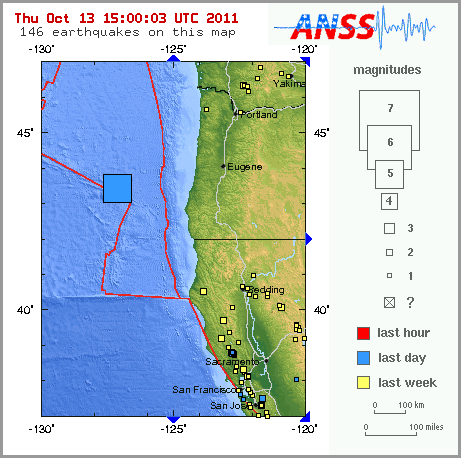
    MAP 5.3 2011/10/13 04:13:59 43.440 -127.155 10.3 OFF THE COAST OF OREGON
    MAP 3.1 2011/10/13 04:05:39 19.129 -67.098 9.0 PUERTO RICO REGION
    MAP 6.1 2011/10/13 03:16:30 -9.378 114.628 35.1 SOUTH OF BALI, INDONESIA
    MAP 2.7 2011/10/13 01:55:42 65.454 -150.063 7.1 NORTHERN ALASKA
    MAP 3.6 2011/10/13 00:21:40 19.598 -65.519 56.9 PUERTO RICO REGION

    Magnitude
    5.3
    Date-Time
    Thursday, October 13, 2011 at 04:13:59 UTC
    Wednesday, October 12, 2011 at 08:13:59 PM at epicenter
    Time of Earthquake in other Time Zones
    Location
    43.440°N, 127.155°W
    Depth
    10.3 km (6.4 miles)
    Region
    OFF THE COAST OF OREGON
    Distances
    233 km (144 miles) W of Coos Bay, Oregon
    277 km (172 miles) WSW of Newport, Oregon
    277 km (172 miles) NW of Brookings, Oregon
    365 km (226 miles) WSW of SALEM, Oregon
    Location Uncertainty
    horizontal +/- 13.2 km (8.2 miles); depth +/- 2.7 km (1.7 miles)
    Parameters
    NST=391, Nph=392, Dmin=238.2 km, Rmss=1.13 sec, Gp= 79°,
    M-type=body wave magnitude (Mb), Version=D
    Source
    Magnitude: USGS NEIC (WDCS-D)
    Location: USGS NEIC (WDCS-D)
    Event ID
    usc00068ex

    The Earthquake/Seismic Activity Log - Page 18 Oregon10


    HigherLove
    HigherLove


    Posts : 2357
    Join date : 2011-01-27
    Age : 59

    The Earthquake/Seismic Activity Log - Page 18 Empty Re: The Earthquake/Seismic Activity Log

    Post  HigherLove Fri Oct 14, 2011 8:00 am

    There have not been any aftershocks yet from the Oregon quake...

    MAP 4.0 2011/10/14 13:03:08 59.444 -145.459 20.9 GULF OF ALASKA
    MAP 4.9 2011/10/14 11:01:45 -18.832 -173.362 40.7 TONGA
    MAP 4.7 2011/10/14 10:01:10 2.506 128.495 111.3 HALMAHERA, INDONESIA
    MAP 4.8 2011/10/14 09:26:54 35.770 140.421 66.6 NEAR THE EAST COAST OF HONSHU, JAPAN
    MAP 2.7 2011/10/14 06:27:38 19.288 -66.870 13.7 PUERTO RICO REGION
    MAP 6.1 2011/10/14 06:10:15 54.114 123.724 15.3 AMURSKAYA OBLAST', RUSSIA
    MAP 4.2 2011/10/14 06:09:28 -5.762 130.796 86.7 BANDA SEA
    MAP 4.9 2011/10/14 03:48:23 -18.900 169.568 283.9 VANUATU
    MAP 6.7 2011/10/14 03:35:15 -6.626 147.927 45.4 EASTERN NEW GUINEA REG, PAPUA NEW GUINEA
    MAP 2.6 2011/10/14 03:23:04 33.598 -118.324 0.0 SAN PEDRO CHANNEL, CALIFORNIA
    MAP 3.1 2011/10/14 01:37:27 18.944 -67.818 69.5 DOMINICAN REPUBLIC REGION
    MAP 3.2 2011/10/14 01:00:30 19.172 -67.800 33.2 DOMINICAN REPUBLIC REGION


    Very strong earthquake almost below Papua New Guinea Finschhafen – NO damage expected

    http://earthquake-report.com/2011/10/04/very-strong-earthquake-almost-below-papua-new-guinea-finschhafen/

    Magnitude
    6.7
    Date-Time
    Friday, October 14, 2011 at 03:35:15 UTC
    Friday, October 14, 2011 at 01:35:15 PM at epicenter
    Time of Earthquake in other Time Zones
    Location
    6.626°S, 147.927°E
    Depth
    45.4 km (28.2 miles)
    Region
    EASTERN NEW GUINEA REG, PAPUA NEW GUINEA
    Distances
    103 km (64 miles) E of Lae, New Guinea, PNG
    184 km (114 miles) WSW of Kandrian, New Britain, PNG
    323 km (200 miles) NNE of PORT MORESBY, Papua New Guinea
    2372 km (1473 miles) NNW of BRISBANE, Queensland, Australia
    Location Uncertainty
    horizontal +/- 14.3 km (8.9 miles); depth +/- 8.5 km (5.3 miles)
    Parameters
    NST=176, Nph=181, Dmin=318.4 km, Rmss=1.27 sec, Gp= 32°,
    M-type=regional moment magnitude (Mw), Version=8
    Source
    Magnitude: NOAA, Pacific Tsunami Warning Center, Honolulu, Hawaii
    Location: USGS NEIC (WDCS-D)
    Event ID
    usc00069ba


    Very strong shallow dangerous earthquake in Amur area, Russia – many aftershocks are reported

    http://earthquake-report.com/2011/10/14/strong-dangerous-shallow-earthquake-in-russia-close-to-the-border-with-china/

    Magnitude
    6.1
    Date-Time
    Friday, October 14, 2011 at 06:10:15 UTC
    Friday, October 14, 2011 at 04:10:15 PM at epicenter
    Time of Earthquake in other Time Zones
    Location
    54.114°N, 123.724°E
    Depth
    15.3 km (9.5 miles)
    Region
    AMURSKAYA OBLAST', RUSSIA
    Distances
    130 km (80 miles) SSW of Tynda, Russia
    211 km (131 miles) NNW of Tahe, Heilongjiang, China
    265 km (164 miles) E of Mogocha, Russia
    5154 km (3202 miles) NE of MOSCOW, Russia
    Location Uncertainty
    horizontal +/- 13 km (8.1 miles); depth +/- 4.4 km (2.7 miles)
    Parameters
    NST=483, Nph=488, Dmin=606.7 km, Rmss=0.69 sec, Gp= 25°,
    M-type="moment" magnitude from initial P wave (tsuboi method) (Mi/Mwp), Version=E
    Source
    Magnitude: USGS NEIC (WDCS-D)
    Location: USGS NEIC (WDCS-D)
    Event ID
    usc00069ck


    The Earthquake/Seismic Activity Log - Page 18 Untitl30

    PLEASE NOTE THAT THE GLOBAL INCIDENT MAP NOW PROVIDES A LIST OF QUAKES FROM AROUND THE WORLD (i.e. instead of using data only from the USGS, they note they are using data from "various governments").

    http://quakes.globalincidentmap.com/

    HigherLove
    HigherLove


    Posts : 2357
    Join date : 2011-01-27
    Age : 59

    The Earthquake/Seismic Activity Log - Page 18 Empty Re: The Earthquake/Seismic Activity Log

    Post  HigherLove Wed Oct 19, 2011 6:35 pm

    MAP 4.7 2011/10/19 21:21:41 37.027 140.382 14.0 EASTERN HONSHU, JAPAN
    MAP 5.0 2011/10/19 20:45:12 -45.712 -77.338 15.3 OFF THE COAST OF AISEN, CHILE
    MAP 2.7 2011/10/19 19:51:09 45.926 -122.422 11.5 WASHINGTON
    MAP 5.0 2011/10/19 19:03:18 15.208 -92.893 85.1 OFFSHORE CHIAPAS, MEXICO
    MAP 3.2 2011/10/19 15:22:10 63.372 -151.218 11.2 CENTRAL ALASKA
    MAP 2.8 2011/10/19 14:27:09 51.736 -176.222 55.7 ANDREANOF ISLANDS, ALEUTIAN IS., ALASKA
    MAP 4.3 2011/10/19 13:31:50 34.559 69.636 38.7 HINDU KUSH REGION, AFGHANISTAN
    MAP 5.1 2011/10/19 13:26:03 -22.732 -113.431 10.0 EASTER ISLAND REGION
    MAP 4.6 2011/10/19 12:03:06 30.210 142.243 24.8 IZU ISLANDS, JAPAN REGION
    MAP 4.8 2011/10/19 11:46:30 -17.512 167.172 9.9 VANUATU
    MAP 4.8 2011/10/19 11:29:36 13.725 119.651 59.2 PHILIPPINE ISLANDS REGION
    MAP 5.2 2011/10/19 10:40:40 -32.290 -13.346 9.8 SOUTHERN MID-ATLANTIC RIDGE
    MAP 2.7 2011/10/19 10:29:50 61.535 -146.393 8.2 SOUTHERN ALASKA
    MAP 3.5 2011/10/19 08:00:59 18.647 -67.951 90.0 DOMINICAN REPUBLIC REGION
    MAP 4.9 2011/10/19 06:23:43 37.996 -31.344 12.2 AZORES ISLANDS REGION
    MAP 2.5 2011/10/19 04:59:19 60.947 -146.662 20.0 SOUTHERN ALASKA
    MAP 4.8 2011/10/19 04:54:25 -4.804 134.150 9.8 NEAR THE SOUTH COAST OF PAPUA, INDONESIA
    MAP 3.5 2011/10/19 04:43:45 19.227 -66.040 41.0 PUERTO RICO REGION
    MAP 5.2 2011/10/19 02:52:44 28.147 54.297 7.0 SOUTHERN IRAN
    MAP 4.8 2011/10/19 02:36:44 31.697 131.149 37.1 KYUSHU, JAPAN
    MAP 4.5 2011/10/19 00:58:07 26.894 53.898 38.9 SOUTHERN IRAN
    MAP 4.9 2011/10/19 00:50:45 -9.487 124.759 29.2 TIMOR REGION
    MAP 2.6 2011/10/19 00:37:41 18.192 -67.100 20.0 PUERTO RICO


    The Earthquake/Seismic Activity Log - Page 18 Untitl31

    2011-10-19 23:19:40.4
    15min ago
    37.16 N 22.07 E 1 2.5 SOUTHERN GREECE
    2011-10-19 22:45:27.8
    49min ago
    51.39 N 16.28 E 10 2.8 POLAND
    2011-10-19 22:41:32.2
    53min ago
    39.71 N 33.28 E 8 2.8 CENTRAL TURKEY
    2011-10-19 21:26:18.7
    2hr 08min ago
    39.52 N 28.76 E 3 2.8 WESTERN TURKEY
    2011-10-19 21:21:44.0
    2hr 13min ago
    37.20 N 140.41 E 40 4.6 EASTERN HONSHU, JAPAN
    2011-10-19 20:49:36.1
    2hr 45min ago
    37.27 N 20.80 E 10 2.6 IONIAN SEA
    2011-10-19 20:45:09.0
    2hr 49min ago
    45.69 S 77.58 W 2 4.9 OFF COAST OF AISEN, CHILE
    2011-10-19 20:35:30.0
    2hr 59min ago
    35.33 N 28.81 E 2 3.2 EASTERN MEDITERRANEAN SEA
    2011-10-19 20:29:33.0
    3hr 05min ago
    42.28 N 13.56 E 18 1.9 CENTRAL ITALY
    2011-10-19 19:39:12.7
    3hr 55min ago
    39.27 N 20.82 E 5 3.6 GREECE
    2011-10-19 19:30:07.5
    4hr 04min ago
    37.42 N 26.92 E 15 2.8 DODECANESE ISLANDS, GREECE
    2011-10-19 19:22:36.0
    4hr 12min ago
    42.49 N 15.51 E 33 2.6 ADRIATIC SEA
    2011-10-19 19:03:19.0
    4hr 31min ago
    15.34 N 92.59 W 100 4.9 CHIAPAS, MEXICO
    2011-10-19 18:51:24.0
    4hr 43min ago
    42.27 N 13.57 E 10 2.5 CENTRAL ITALY
    2011-10-19 18:49:48.4
    4hr 45min ago
    37.11 N 22.00 E 5 3.0 SOUTHERN GREECE
    2011-10-19 18:31:10.0
    5hr 03min ago
    39.15 N 42.12 E 7 3.0 EASTERN TURKEY
    2011-10-19 18:28:46.2
    5hr 06min ago
    36.44 N 25.46 E 5 2.4 DODECANESE ISLANDS, GREECE
    2011-10-19 18:03:17.2
    5hr 31min ago
    27.78 N 18.06 W 22 2.6 CANARY ISLANDS, SPAIN REGION
    2011-10-19 18:02:20.7
    5hr 32min ago
    38.12 N 38.46 E 5 2.8 EASTERN TURKEY
    2011-10-19 17:55:17.0
    5hr 39min ago
    42.12 N 6.70 W 18 2.0 SPAIN
    2011-10-19 17:41:37.5
    5hr 53min ago
    40.05 N 19.93 E 3 3.0 ALBANIA
    2011-10-19 17:33:31.0
    6hr 01min ago
    34.86 N 23.88 E 15 2.6 CRETE, GREECE
    2011-10-19 17:13:36.7
    6hr 21min ago
    39.61 N 143.49 E 42 4.5 OFF EAST COAST OF HONSHU, JAPAN
    2011-10-19 17:10:40.9
    6hr 24min ago
    36.86 N 22.04 E 12 2.2 SOUTHERN GREECE
    2011-10-19 15:57:59.0
    7hr 37min ago
    36.41 N 19.96 E 10 2.3 CENTRAL MEDITERRANEAN SEA
    2011-10-19 15:33:50.3
    8hr 01min ago
    35.02 N 23.85 E 8 2.7 CRETE, GREECE
    2011-10-19 15:22:00.0
    8hr 13min ago
    35.51 N 23.48 E 2 2.5 CRETE, GREECE
    2011-10-19 14:32:37.7
    9hr 02min ago
    39.61 N 33.28 E 6 2.8 CENTRAL TURKEY
    2011-10-19 14:19:18.0
    9hr 15min ago
    40.04 N 44.47 E 2 3.5 ARMENIA
    2011-10-19 13:34:19.0
    10hr 00min ago
    39.66 N 38.70 E 4 3.7 EASTERN TURKEY
    2011-10-19 13:31:52.0
    10hr 03min ago
    34.67 N 69.81 E 60 4.6 HINDU KUSH REGION, AFGHANISTAN
    2011-10-19 13:26:07.0
    10hr 08min ago
    22.60 S 113.47 W 33 5.0 EASTER ISLAND REGION
    2011-10-19 12:54:11.0
    10hr 40min ago
    42.80 N 13.50 E 10 2.0 CENTRAL ITALY
    2011-10-19 12:35:48.0
    10hr 59min ago
    36.13 N 29.27 E 3 3.1 WESTERN TURKEY
    2011-10-19 12:03:04.0
    11hr 31min ago
    30.23 N 142.19 E 10 4.8 IZU ISLANDS, JAPAN REGION
    2011-10-19 11:46:31.0
    11hr 48min ago
    17.59 S 167.18 E 20 4.8 VANUATU
    2011-10-19 11:29:34.0 13.70 N 119.78 E 60 4.9 PHILIPPINE ISLANDS REGION
    2011-10-19 11:05:23.9 39.65 N 29.50 E 4 2.6 WESTERN TURKEY
    2011-10-19 10:57:24.4 39.62 N 29.43 E 7 2.7 WESTERN TURKEY
    2011-10-19 10:40:39.0 32.26 S 13.41 W 2 5.2 SOUTHERN MID-ATLANTIC RIDGE
    2011-10-19 10:13:38.0 42.53 N 13.17 E 10 2.2 CENTRAL ITALY
    2011-10-19 10:07:26.3 37.23 N 38.96 E 12 1.8 EASTERN TURKEY
    2011-10-19 10:04:59.0 42.54 N 13.17 E 11 2.4 CENTRAL ITALY
    2011-10-19 10:00:16.0 42.52 N 13.18 E 10 2.1 CENTRAL ITALY
    2011-10-19 09:52:26.4 39.11 N 29.05 E 5 2.9 WESTERN TURKEY
    2011-10-19 09:51:18.7 36.99 N 36.01 E 5 2.4 TURKEY-SYRIA BORDER REGION
    2011-10-19 09:19:32.3 38.04 N 23.66 E 21 2.4 GREECE
    2011-10-19 09:13:37.0 42.54 N 13.17 E 11 2.3 CENTRAL ITALY
    2011-10-19 08:11:06.0 26.19 N 143.82 E 40 4.7 BONIN ISLANDS, JAPAN REGION
    2011-10-19 07:35:30.9 39.36 N 22.76 E 10 2.4 GREECE
    Carol
    Carol
    Admin
    Admin


    Posts : 32911
    Join date : 2010-04-07
    Location : Hawaii

    The Earthquake/Seismic Activity Log - Page 18 Empty Re: The Earthquake/Seismic Activity Log

    Post  Carol Wed Oct 19, 2011 8:18 pm

    Hah! I'm standing in the middle of the grocery store when suddenly there is this mega jolt. We all say, "It's a 4." Actually is was a 4.4 with the epic center at Mauna Kea, a dormant volcano.... and my house is built on the side of this dormant volcano. The after shock was about 5 minutes later and around a 2. The girls a bit shocked and nervous headed out of the store and stayed outside, while I headed off to the chocolate cream pie and added it to my shopping basket along with some chocolate chip cookings. There is nothing like a little comfort food when stressed.


    DATE................................. LAT......LOG.......MAG... DEPTH km REGION
    19-OCT-2011 00:10:04 19.88 -155.53 ....4.4.......17.1 ... HAWAII


    _________________
    What is life?
    It is the flash of a firefly in the night, the breath of a buffalo in the wintertime. It is the little shadow which runs across the grass and loses itself in the sunset.

    With deepest respect ~ Aloha & Mahalo, Carol
    lindabaker
    lindabaker


    Posts : 1385
    Join date : 2010-04-15
    Location : straight ahead

    The Earthquake/Seismic Activity Log - Page 18 Empty Re: The Earthquake/Seismic Activity Log

    Post  lindabaker Wed Oct 19, 2011 8:55 pm

    Carol...Carol...where are you? Keep us posted, there have been nine ? quakes in Hawaii according to my sources in Australia..
    Carol
    Carol
    Admin
    Admin


    Posts : 32911
    Join date : 2010-04-07
    Location : Hawaii

    The Earthquake/Seismic Activity Log - Page 18 Empty Re: The Earthquake/Seismic Activity Log

    Post  Carol Wed Oct 19, 2011 8:58 pm

    Thank you for your concern Linda. I'm on Big Island on the north end and only felt the 2 this afternoon. Usually they are off the coast in the water but today was a surprise. Mauna Kea? I have to check some other sources and see if that was really where it was located.

    I see that Oklahoma had a 4.4 too.

    Good gad...

    http://earthquake.usgs.gov/earthquakes/recenteqsww/Quakes/quakes_all.php
    http://maps.google.com.br/maps?q=Mauna%20Kea%20volcano&hl=pt-BR&ll=19.827434,-155.424271&spn=0.32297,0.617294&sll=20.007226,-155.686226&sspn=0.153559,0.308647&vpsrc=6&hnear=Mauna%20Kea&t=m&z=11
    http://quakes.globalincidentmap.com/

    MAP 2.5 2011/10/20 01:24:06 19.875 -155.537 17.9 ISLAND OF HAWAII, HAWAII
    MAP 2.7 2011/10/20 01:11:01 19.863 -155.533 17.0 ISLAND OF HAWAII, HAWAII
    MAP 3.3 2011/10/20 00:59:00 19.884 -155.539 19.5 ISLAND OF HAWAII, HAWAII
    MAP 2.6 2011/10/20 00:48:02 19.881 -155.541 16.7 ISLAND OF HAWAII, HAWAII
    MAP 2.8 2011/10/20 00:45:17 19.879 -155.545 15.2 ISLAND OF HAWAII, HAWAII
    MAP 2.5 2011/10/20 00:27:45 19.878 -155.536 18.6 ISLAND OF HAWAII, HAWAII
    MAP 3.1 2011/10/20 00:21:04 19.871 -155.543 15.7 ISLAND OF HAWAII, HAWAII
    MAP 3.6 2011/10/20 00:12:35 19.882 -155.533 16.6 ISLAND OF HAWAII, HAWAII
    MAP 4.5 2011/10/20 00:10:04 19.886 -155.533 18.7 ISLAND OF HAWAII, HAWAII


    Complete list - http://tux.wr.usgs.gov/Maps/155.5-19.75.html
    MAP 2.3 2011/10/20 01:29:13 19.881 -155.547 17.0 21 km ( 13 mi) SE of Waimea, HI
    MAP 3.0 2011/10/20 01:24:05 19.876 -155.541 16.6 21 km ( 13 mi) SE of Waimea, HI
    MAP 2.1 2011/10/20 01:22:20 19.890 -155.545 17.6 20 km ( 12 mi) SE of Waimea, HI
    MAP 3.0 2011/10/20 01:11:01 19.857 -155.537 15.2 23 km ( 14 mi) SE of Waimea, HI
    MAP 2.1 2011/10/20 01:04:37 19.880 -155.545 18.0 21 km ( 13 mi) SE of Waimea, HI
    MAP 3.3 2011/10/20 00:59:00 19.884 -155.539 19.5 21 km ( 13 mi) SE of Waimea, HI
    MAP 2.4 2011/10/20 00:57:03 19.855 -155.542 14.8 23 km ( 14 mi) SE of Waimea, HI
    MAP 2.6 2011/10/20 00:48:01 19.881 -155.541 16.7 21 km ( 13 mi) SE of Waimea, HI
    MAP 2.4 2011/10/20 00:45:56 19.845 -155.546 14.7 24 km ( 15 mi) SE of Waimea, HI
    MAP 2.8 2011/10/20 00:45:17 19.879 -155.545 15.2 21 km ( 13 mi) SE of Waimea, HI
    MAP 2.1 2011/10/20 00:33:40 19.886 -155.548 18.1 20 km ( 12 mi) SE of Waimea, HI
    MAP 1.7 2011/10/20 00:31:52 19.858 -155.527 16.2 24 km ( 15 mi) SE of Waimea, HI
    MAP 2.0 2011/10/20 00:30:47 19.838 -155.408 16.7 23 km ( 14 mi) S of Paauilo, HI
    MAP 2.5 2011/10/20 00:27:44 19.878 -155.536 18.6 21 km ( 13 mi) SE of Waimea, HI
    MAP 2.4 2011/10/20 00:25:25 19.874 -155.547 16.3 21 km ( 13 mi) SE of Waimea, HI
    MAP 3.1 2011/10/20 00:21:04 19.871 -155.543 15.7 22 km ( 13 mi) SE of Waimea, HI
    MAP 2.0 2011/10/20 00:18:11 19.865 -155.522 16.9 24 km ( 15 mi) SE of Waimea, HI
    MAP 1.9 2011/10/20 00:16:15 19.883 -155.541 17.8 21 km ( 13 mi) SE of Waimea, HI
    MAP 3.6 2011/10/20 00:12:34 19.882 -155.533 16.6 21 km ( 13 mi) SE of Waimea, HI
    MAP 4.5 2011/10/20 00:10:04 19.886 -155.533 18.7 21 km ( 13 mi) SE of Waimea, HI

    More Than A Dozen Earthquakes Shake The Big Island
    HONOLULU -- More than a dozen earthquakes on the Waimea side of Mauna Kea shook the Big Island Wednesday afternoon, according to the U.S. Geological Survey and local officials. No word on damage or injuries.

    There is no threat of a tsunami.

    The first earthquake happened at around 2:10 p.m. around 13 miles southeast of Waimea, according to the USGS.

    The USGS says the magnitude of the largest earthquake measured was at 4.5. Other agencies, like the Hawaii County Civil Defense, says it was a magnitude 4.3 The weakest earthquake measured at a magnitude 1.0, according to the USGS.

    The last recorded earthquake happened at 3:24 p.m. with a magnitude of 3.0.

    Read more: http://www.kitv.com/news/29534774/detail.html#ixzz1bHmD4dZJ

    http://hisz.rsoe.hu/alertmap/index2.php?lang=


    _________________
    What is life?
    It is the flash of a firefly in the night, the breath of a buffalo in the wintertime. It is the little shadow which runs across the grass and loses itself in the sunset.

    With deepest respect ~ Aloha & Mahalo, Carol
    HigherLove
    HigherLove


    Posts : 2357
    Join date : 2011-01-27
    Age : 59

    The Earthquake/Seismic Activity Log - Page 18 Empty Re: The Earthquake/Seismic Activity Log

    Post  HigherLove Thu Oct 20, 2011 2:48 pm

    Moderate extremely shallow (fracking?) earthquake in Atascosa County, Texas, United States

    The Earthquake/Seismic Activity Log - Page 18 Texas-10

    Reader Steve Blanke wrote us : I don’t expect you to be familiar with fault zones in Texas, but there are a number of relatively major fault zones in this area, also known as the Fashing fault zone. They aren’t basement-related, but rather are down to the coast faults along the steep hingeline just basinward of the Cretaceous-aged Edwards or Stewart City shelf margin. There was also an earthquake of about the same magnitude in this area in 1973. I really wish you wouldn’t try to tie this to fracing without knowing more about the regional geology.

    http://earthquake-report.com/2011/10/20/moderate-extremely-shallow-earthquake-in-atascosa-county-texas-united-states/


    Magnitude
    4.8
    Date-Time
    Thursday, October 20, 2011 at 12:24:40 UTC
    Thursday, October 20, 2011 at 07:24:40 AM at epicenter
    Time of Earthquake in other Time Zones
    Location
    28.806°N, 98.147°W
    Depth
    3 km (1.9 miles) (poorly constrained)
    Region
    SOUTHERN TEXAS
    Distances
    60 km (37 miles) NW of Beeville, Texas
    76 km (47 miles) SSE of San Antonio, Texas
    92 km (57 miles) E of Pearsall, Texas
    166 km (103 miles) SSW of AUSTIN, Texas
    Location Uncertainty
    horizontal +/- 19.3 km (12.0 miles); depth +/- 3.1 km (1.9 miles)
    Parameters
    NST= 23, Nph= 23, Dmin=142.5 km, Rmss=0.81 sec, Gp=108°,
    M-type=centroid moment magnitude (Mw), Version=6
    Source
    Magnitude: USGS NEIC (WDCS-D)
    Location: USGS NEIC (WDCS-D)
    Event ID
    usb0006alu


    MAP 5.0 2011/10/20 17:18:35 21.181 70.540 15.5 GUJARAT, INDIA
    MAP 5.1 2011/10/20 16:07:24 -52.504 140.217 15.2 WEST OF MACQUARIE ISLAND
    MAP 2.6 2011/10/20 15:26:47 62.065 -149.357 41.1 CENTRAL ALASKA
    MAP 4.8 2011/10/20 12:24:41 28.806 -98.147 3.0 SOUTHERN TEXAS
    MAP 2.5 2011/10/20 10:05:29 19.881 -155.544 17.8 ISLAND OF HAWAII, HAWAII
    MAP 3.2 2011/10/20 09:42:07 19.873 -155.538 19.2 ISLAND OF HAWAII, HAWAII
    MAP 3.2 2011/10/20 09:14:15 18.588 -65.037 25.2 VIRGIN ISLANDS REGION
    MAP 3.1 2011/10/20 07:47:47 18.621 -67.974 79.6 DOMINICAN REPUBLIC REGION
    MAP 4.5 2011/10/20 06:57:26 27.537 56.219 10.0 SOUTHERN IRAN
    MAP 2.6 2011/10/20 06:04:29 19.887 -155.544 16.6 ISLAND OF HAWAII, HAWAII
    MAP 3.7 2011/10/20 04:17:33 19.304 -155.221 9.9 ISLAND OF HAWAII, HAWAII
    MAP 4.8 2011/10/20 03:38:59 -29.972 -176.298 34.7 KERMADEC ISLANDS REGION
    MAP 2.5 2011/10/20 03:21:26 19.871 -155.549 14.3 ISLAND OF HAWAII, HAWAII
    MAP 2.7 2011/10/20 03:16:09 19.881 -155.546 19.3 ISLAND OF HAWAII, HAWAII
    MAP 3.0 2011/10/20 02:45:05 18.890 -67.201 9.9 PUERTO RICO REGION
    MAP 2.5 2011/10/20 01:24:06 19.875 -155.537 17.9 ISLAND OF HAWAII, HAWAII
    MAP 2.7 2011/10/20 01:11:01 19.863 -155.533 17.0 ISLAND OF HAWAII, HAWAII
    MAP 3.3 2011/10/20 00:59:00 19.884 -155.539 19.5 ISLAND OF HAWAII, HAWAII
    MAP 2.6 2011/10/20 00:48:02 19.881 -155.541 16.7 ISLAND OF HAWAII, HAWAII
    MAP 2.8 2011/10/20 00:45:17 19.879 -155.545 15.2 ISLAND OF HAWAII, HAWAII
    MAP 2.5 2011/10/20 00:27:45 19.878 -155.536 18.6 ISLAND OF HAWAII, HAWAII
    MAP 3.1 2011/10/20 00:21:04 19.871 -155.543 15.7 ISLAND OF HAWAII, HAWAII
    MAP 3.6 2011/10/20 00:12:35 19.880 -155.528 18.4 ISLAND OF HAWAII, HAWAII
    MAP 4.5 2011/10/20 00:10:04 19.883 -155.532 18.8 ISLAND OF HAWAII, HAWAII
    MAP 4.3 2011/10/20 00:05:09 14.215 -90.812 79.9 GUATEMALA

    The Earthquake/Seismic Activity Log - Page 18 Index10


    The Earthquake/Seismic Activity Log - Page 18 Untitl32

      Current date/time is Tue Nov 19, 2024 12:24 am