tMoA

Would you like to react to this message? Create an account in a few clicks or log in to continue.
tMoA

~ The only Home on the Web You'll ever need ~

+21
Aquaries1111
giovonni
arvan33
Floyd
lawlessline
JesterTerrestrial
THEeXchanger
newel
Brook
greybeard
Mercuriel
Sanicle
devakas
hobbit
mudra
burgundia
lindabaker
LeeEllisMusic
MargueriteBee
Carol
HigherLove
25 posters

    The Earthquake/Seismic Activity Log

    HigherLove
    HigherLove


    Posts : 2357
    Join date : 2011-01-27
    Age : 58

    The Earthquake/Seismic Activity Log - Page 4 Empty Re: The Earthquake/Seismic Activity Log

    Post  HigherLove Mon Apr 18, 2011 12:00 pm

    In case the Atlantic was feeling left out -


    Magnitude 4.6
    Date-Time Monday, April 18, 2011 at 15:38:03 UTC
    Monday, April 18, 2011 at 11:38:03 AM at epicenter
    Time of Earthquake in other Time Zones

    Location 32.454°N, 65.707°W
    Depth 10 km (6.2 miles) set by location program
    Region BERMUDA REGION
    Distances 88 km (54 miles) WNW of HAMILTON, Bermuda
    992 km (616 miles) ESE of Nags Head, North Carolina
    994 km (617 miles) ESE of Ocracoke, North Carolina
    1197 km (743 miles) SSE of BOSTON, Massachusetts

    Location Uncertainty horizontal +/- 6.3 km (3.9 miles); depth fixed by location program
    Parameters NST= 94, Nph= 94, Dmin=95.6 km, Rmss=1.19 sec, Gp= 79°,
    M-type=body wave magnitude (Mb), Version=7
    Source USGS NEIC (WDCS-D)


    Event ID us2011jwa8
    HigherLove
    HigherLove


    Posts : 2357
    Join date : 2011-01-27
    Age : 58

    The Earthquake/Seismic Activity Log - Page 4 Empty Re: The Earthquake/Seismic Activity Log

    Post  HigherLove Mon Apr 18, 2011 5:17 pm

    Magnitude 3.8
    Date-Time Monday, April 18, 2011 at 21:57:19 UTC
    Monday, April 18, 2011 at 02:57:19 PM at epicenter

    Location 37.597°N, 122.455°W
    Depth 13.6 km (8.5 miles)
    Region SAN FRANCISCO BAY AREA, CALIFORNIA
    Distances 4 km (2 miles) SE (136°) from Pacifica, CA
    4 km (2 miles) SW (220°) from San Bruno, CA
    5 km (3 miles) W (266°) from Millbrae, CA
    10 km (6 miles) S (175°) from Daly City, CA
    20 km (12 miles) S (189°) from San Francisco City Hall, CA

    Location Uncertainty horizontal +/- 0.2 km (0.1 miles); depth +/- 0.4 km (0.2 miles)
    Parameters Nph= 79, Dmin=4 km, Rmss=0.1 sec, Gp= 72°,
    M-type=local magnitude (ML), Version=3
    Source California Integrated Seismic Net:
    USGS Caltech CGS UCB UCSD UNR

    Event ID nc71560691
    HigherLove
    HigherLove


    Posts : 2357
    Join date : 2011-01-27
    Age : 58

    The Earthquake/Seismic Activity Log - Page 4 Empty Re: The Earthquake/Seismic Activity Log

    Post  HigherLove Mon Apr 18, 2011 5:23 pm

    PACIFICA, Calif. (KGO) -- A small earthquake with a preliminary magnitude of 3.8 shook parts of the Peninsula this afternoon.

    The epicenter of the quake was 2 miles southeast of Pacifica, according to the USGS. It struck at 2.57 p.m. on the San Andreas Fault. A small 1.4 aftershock struck three minutes later.

    http://abclocal.go.com/kgo/story?section=news/local/peninsula&id=8080322

    _____________________

    3.8 Earthquake Hits Near Pacifica
    Posted: 3:05 pm PDT April 18, 2011
    Updated: 3:19 pm PDT April 18, 2011

    PACIFICA, Calif. -- A 3.8 earthquake rattled parts of the Bay Area Monday afternoon, hitting south of San Francisco on the day of the 105th anniversary of the city's Great 1906 Earthquake.

    The quake, which occurred shortly before 3 p.m., was centered about 2 miles from Pacifica, according to the U.S. Geological Survey.

    No injuries were immediately reported, but BART trains were reported to have shut down temporarily.

    More details will be posted when they become available.

    Below is a map showing where the quake hit Monday afternoon.

    http://www.ktvu.com/news/27589716/detail.html


    Last edited by HigherLove on Mon Apr 18, 2011 5:41 pm; edited 1 time in total
    HigherLove
    HigherLove


    Posts : 2357
    Join date : 2011-01-27
    Age : 58

    The Earthquake/Seismic Activity Log - Page 4 Empty Re: The Earthquake/Seismic Activity Log

    Post  HigherLove Mon Apr 18, 2011 5:37 pm

    Two miles from SFO - Carol you are leaving a trail. lol

    http://www.themistsofavalon.net/t2163-california-san-andreas-fault-current-data

    The Earthquake/Seismic Activity Log - Page 4 Untitl15
    HigherLove
    HigherLove


    Posts : 2357
    Join date : 2011-01-27
    Age : 58

    The Earthquake/Seismic Activity Log - Page 4 Empty Re: The Earthquake/Seismic Activity Log

    Post  HigherLove Mon Apr 18, 2011 5:52 pm

    Magnitude 3.0
    Date-Time Monday, April 18, 2011 at 22:47:02 UTC
    Monday, April 18, 2011 at 03:47:02 PM at epicenter

    Location 37.524°N, 118.826°W
    Depth 7.8 km (4.8 miles)
    Region CENTRAL CALIFORNIA
    Distances 14 km (8 miles) WSW (252°) from Toms Place, CA
    18 km (12 miles) SE (133°) from Mammoth Lakes, CA
    24 km (15 miles) WNW (301°) from Round Valley, CA
    258 km (160 miles) ESE (116°) from Sacramento, CA

    Location Uncertainty horizontal +/- 0.3 km (0.2 miles); depth +/- 0.7 km (0.4 miles)
    Parameters Nph= 33, Dmin=7 km, Rmss=0.05 sec, Gp=101°,
    M-type=duration magnitude (Md), Version=1
    Source California Integrated Seismic Net:
    USGS Caltech CGS UCB UCSD UNR

    Event ID nc71560731
    HigherLove
    HigherLove


    Posts : 2357
    Join date : 2011-01-27
    Age : 58

    The Earthquake/Seismic Activity Log - Page 4 Empty Re: The Earthquake/Seismic Activity Log

    Post  HigherLove Mon Apr 18, 2011 6:13 pm

    Swarming, again...

    Magnitude 4.5
    Date-Time Monday, April 18, 2011 at 22:40:35 UTC
    Tuesday, April 19, 2011 at 05:40:35 AM at epicenter
    Time of Earthquake in other Time Zones

    Location 0.329°N, 98.695°E
    Depth 65.9 km (41.0 miles)
    Region NIAS REGION, INDONESIA
    Distances 132 km (82 miles) SSW of Padangsidempuan, Sumatra, Indonesia
    156 km (96 miles) S of Sibolga, Sumatra, Indonesia
    458 km (284 miles) SW of KUALA LUMPUR, Malaysia
    1155 km (717 miles) NW of JAKARTA, Java, Indonesia

    Location Uncertainty horizontal +/- 18.2 km (11.3 miles); depth +/- 9.3 km (5.8 miles)
    Parameters NST= 39, Nph= 44, Dmin=164.8 km, Rmss=1.05 sec, Gp=119°,
    M-type=body wave magnitude (Mb), Version=5
    Source USGS NEIC (WDCS-D)


    Event ID usc0002ufi
    HigherLove
    HigherLove


    Posts : 2357
    Join date : 2011-01-27
    Age : 58

    The Earthquake/Seismic Activity Log - Page 4 Empty Re: The Earthquake/Seismic Activity Log

    Post  HigherLove Mon Apr 18, 2011 7:05 pm

    Magnitude
    2.4
    Date-Time
    Monday, April 18, 2011 at 23:55:41 UTC
    Monday, April 18, 2011 at 04:55:41 PM at epicenter
    Location
    37.607°N, 122.455°W
    Depth
    12.5 km (7.8 miles)
    Region
    SAN FRANCISCO BAY AREA, CALIFORNIA
    Distances
    3 km (2 miles) SE (124°) from Pacifica, CA
    3 km (2 miles) SW (232°) from San Bruno, CA
    5 km (3 miles) W (278°) from Millbrae, CA
    9 km (6 miles) S (174°) from Daly City, CA
    14 km (9 miles) WNW (295°) from San Mateo, CA
    19 km (12 miles) S (190°) from San Francisco City Hall, CA
    Location Uncertainty
    horizontal +/- 0.2 km (0.1 miles); depth +/- 0.3 km (0.2 miles)
    Parameters
    Nph= 64, Dmin=4 km, Rmss=0.08 sec, Gp= 61°,
    M-type=duration magnitude (Md), Version=1
    Source
    California Integrated Seismic Net:
    USGS Caltech CGS UCB UCSD UNR
    Event ID
    nc71560786
    HigherLove
    HigherLove


    Posts : 2357
    Join date : 2011-01-27
    Age : 58

    The Earthquake/Seismic Activity Log - Page 4 Empty Re: The Earthquake/Seismic Activity Log

    Post  HigherLove Mon Apr 18, 2011 8:15 pm

    Magnitude
    5.2
    Date-Time
    Tuesday, April 19, 2011 at 00:57:29 UTC
    Monday, April 18, 2011 at 08:57:29 PM at epicenter
    Location
    33.356°S, 72.051°W
    Depth
    20.7 km (12.9 miles)
    Region
    OFFSHORE VALPARAISO, CHILE
    Distances
    47 km (29 miles) SW (230°) from Valparaiso, Chile
    129 km (80 miles) W (277°) from SANTIAGO, Chile
    237 km (148 miles) N (351°) from Talca, Chile
    Location Uncertainty
    horizontal +/- 13.9 km (8.6 miles); depth +/- 7.2 km (4.5 miles)
    Parameters
    NST= 99, Nph=108, Dmin=105.8 km, Rmss=1.06 sec, Gp=130°,
    M-type=body wave magnitude (Mb), Version=5
    Source
    U.S. Geological Survey, National Earthquake Information Center:
    World Data Center for Seismology, Denver
    Event ID
    usc0002uhi
    HigherLove
    HigherLove


    Posts : 2357
    Join date : 2011-01-27
    Age : 58

    The Earthquake/Seismic Activity Log - Page 4 Empty Re: The Earthquake/Seismic Activity Log

    Post  HigherLove Mon Apr 18, 2011 9:32 pm

    HigherLove
    HigherLove


    Posts : 2357
    Join date : 2011-01-27
    Age : 58

    The Earthquake/Seismic Activity Log - Page 4 Empty Re: The Earthquake/Seismic Activity Log

    Post  HigherLove Mon Apr 18, 2011 10:02 pm

    My myth may be busted...

    These are pretty close to midnight:

    1.1 2011/04/17 00:42:58 38.821N 122.808W 2.3 2 km ( 2 mi) N of The Geysers, CA
    2.0 2011/04/17 00:18:28 38.448N 122.636W 5.9 6 km ( 4 mi) E of Santa Rosa, CA
    Carol
    Carol
    Admin
    Admin


    Posts : 31800
    Join date : 2010-04-07
    Location : Hawaii

    The Earthquake/Seismic Activity Log - Page 4 Empty Re: The Earthquake/Seismic Activity Log

    Post  Carol Mon Apr 18, 2011 11:43 pm

    hmmm, this must mean the earth never sleeps Troy. I was just reading about how thin the magnetic field was and how Mexico City was being bombared by gamma rays.

    Mexico city under severe gamma rays attack!! we are loosing our magnetic field.


    http://link.brightcove.com/services/player/bcpid709566419001?bckey=AQ~~,AAAADXbYjDE~,3aLFJqpM7Ieh4Zw7nKsgGitMWKq683rN&bctid=907529555001

    For 8 days in a row authorities declare an alert of severe radiation from the SUN. We had a 13 alert grade in a scale of 15 this never happens before.

    They are asking people to stay inside... and not to expose to the sun for more than 15 minutes and to wear sun blockers for those 15 min...

    They are giving out free sunblock samples, hats and water...

    How's your spanish? http://www.eluniversal.com.mx/notas/759734.html

    and

    http://www.uvawareness.com/uv-forecast/uv-forecast.php?location=mexico

    http://www.agu.org/pubs/crossref/2000/1999JD900250.shtml

    http://link.brightcove.com/services/player/bcpid709566419001?bckey=AQ~~,AAAADXbYjDE~,3aLFJqpM7Ieh4Zw7nKsgGitMWKq683rN&bctid=907529555001

    http://www.elfinanciero.com.mx/index.php/sociedad/21061

    http://www.milenio.com/node/696556

    http://www.cronica.com.mx/nota.php?id_nota=573116

    http://www.cronica.com.mx/nota.php?id_nota=572692

    http://translate.google.com/translate?js=n&prev=_t&hl=en&ie=UTF-8&layout=2&eotf=1&sl=es&tl=en&u=http%3A%2F%2Fwww.milenio.com%2Fnode%2F694466

    Perhaps we need to be monitoring gamma rays to see what's going on as I suspect they heat up magma which may result in quakes as well.


    _________________
    What is life?
    It is the flash of a firefly in the night, the breath of a buffalo in the wintertime. It is the little shadow which runs across the grass and loses itself in the sunset.

    With deepest respect ~ Aloha & Mahalo, Carol
    HigherLove
    HigherLove


    Posts : 2357
    Join date : 2011-01-27
    Age : 58

    The Earthquake/Seismic Activity Log - Page 4 Empty Re: The Earthquake/Seismic Activity Log

    Post  HigherLove Tue Apr 19, 2011 5:40 am

    Thanks, Carol!
    _______________________


    Magnitude
    4.9
    Date-Time
    Tuesday, April 19, 2011 at 09:08:04 UTC
    Tuesday, April 19, 2011 at 12:08:04 PM at epicenter
    Time of Earthquake in other Time Zones
    Location
    12.056°N, 43.972°E
    Depth
    14.3 km (8.9 miles)
    Region
    NEAR THE COAST OF YEMEN
    Distances
    103 km (64 miles) ENE of DJIBOUTI, Djibouti
    138 km (85 miles) SW of Aden, Yemen
    166 km (103 miles) S of Taizz, Yemen
    170 km (105 miles) SE of Assab, Eritrea
    Location Uncertainty
    horizontal +/- 26.5 km (16.5 miles); depth +/- 7.3 km (4.5 miles)
    Parameters
    NST= 29, Nph= 29, Dmin=281.6 km, Rmss=1.04 sec, Gp=130°,
    M-type=body wave magnitude (Mb), Version=4
    Source
    USGS NEIC (WDCS-D)
    Event ID
    usc0002ulc

    http://en.wikipedia.org/wiki/Dead_Sea_Transform

    Eventually, this one may rear itself -

    The Earthquake/Seismic Activity Log - Page 4 Middle10
    clicking on graphic just takes you to my pics


    The Earthquake/Seismic Activity Log - Page 4 Untitl21

    MAP 4.7 2011/04/19 09:37:56 12.014 44.117 11.1 NEAR THE COAST OF YEMEN
    MAP 4.9 2011/04/19 09:08:04 12.056 43.972 14.3 NEAR THE COAST OF YEMEN
    MAP 5.4 2011/04/19 03:53:23 -56.464 -25.535 25.4 SOUTH SANDWICH ISLANDS REGION
    MAP 4.8 2011/04/15 08:49:33 -4.257 35.729 9.8 TANZANIA
    MAP 5.4 2011/04/15 05:02:15 -55.583 -28.139 47.0 SOUTH SANDWICH ISLANDS REGION
    MAP 4.5 2011/04/15 03:18:29 36.520 23.049 10.0 SOUTHERN GREECE
    HigherLove
    HigherLove


    Posts : 2357
    Join date : 2011-01-27
    Age : 58

    The Earthquake/Seismic Activity Log - Page 4 Empty Re: The Earthquake/Seismic Activity Log

    Post  HigherLove Tue Apr 19, 2011 6:00 am

    The Dead Sea Transform Fault:
    Its expression in the magnetic field


    http://woodshole.er.usgs.gov/project-pages/dead_sea/magnetic.html


    Major Quake, Tsunami Likely in Middle East, Study Finds

    In A.D. 551, a massive earthquake spawned huge tsunamis that devastated the coast of Phoenicia, now Lebanon.

    Now a new underwater survey has finally uncovered the fault likely responsible for the catastrophe and shown that it rumbles approximately every 1,500 years—which means a disaster is due any day now.

    "It is just a matter of time before a destructive tsunami hits this region again," said Iain Stewart, an earthquake expert at the University of Plymouth in the United Kingdom not involved in the underwater survey.

    The ample archaeological and historical evidence from the A.D. 551 earthquake indicate that it was truly a catastrophic event. The resulting tsunami damaged all major coastal cities between Tripoli and Tyr, and Tripoli was reported to have "drowned." (See a Lebanon map.)

    http://news.nationalgeographic.com/news/2007/07/070726-lebanon-quake.html
    _______________

    Arabian Plate -

    http://en.wikipedia.org/wiki/Arabian_Plate

    African Plate -

    http://en.wikipedia.org/wiki/African_Plate
    HigherLove
    HigherLove


    Posts : 2357
    Join date : 2011-01-27
    Age : 58

    The Earthquake/Seismic Activity Log - Page 4 Empty Re: The Earthquake/Seismic Activity Log

    Post  HigherLove Tue Apr 19, 2011 6:07 am

    Magnitude
    2.0
    Date-Time
    Tuesday, April 19, 2011 at 11:00:48 UTC
    Tuesday, April 19, 2011 at 04:00:48 AM at epicenter
    Location
    47.931°N, 121.884°W
    Depth
    15.7 km (9.8 miles) set by location program
    Region
    PUGET SOUND REGION, WASHINGTON
    Distances
    5 km (3 miles) N (11°) from Woods Creek, WA
    6 km (4 miles) SSE (155°) from Lake Roesiger, WA
    7 km (5 miles) NW (313°) from North Sultan, WA
    11 km (7 miles) NE (44°) from Monroe, WA
    42 km (26 miles) NNE (29°) from Bellevue, WA
    48 km (30 miles) NE (45°) from Seattle, WA
    Location Uncertainty
    horizontal +/- 0.7 km (0.4 miles); depth fixed by location program
    Parameters
    NST= 33, Nph= 33, Dmin=15 km, Rmss=0.31 sec, Gp= 43°,
    M-type=duration magnitude (Md), Version=0
    Source
    Pacific Northwest Seismograph Network
    Event ID
    uw04191100
    HigherLove
    HigherLove


    Posts : 2357
    Join date : 2011-01-27
    Age : 58

    The Earthquake/Seismic Activity Log - Page 4 Empty Re: The Earthquake/Seismic Activity Log

    Post  HigherLove Tue Apr 19, 2011 7:08 am

    Magnitude
    4.7
    Date-Time
    Tuesday, April 19, 2011 at 11:33:24 UTC
    Tuesday, April 19, 2011 at 10:33:24 PM at epicenter
    Time of Earthquake in other Time Zones
    Location
    21.674°S, 169.695°E
    Depth
    61.1 km (38.0 miles)
    Region
    SOUTHEAST OF THE LOYALTY ISLANDS
    Distances
    188 km (116 miles) E of Tadine, Loyalty Islands, New Caledonia
    239 km (148 miles) S of Isangel, Tanna, Vanuatu
    342 km (212 miles) E of NOUMEA, New Caledonia
    1807 km (1122 miles) ENE of BRISBANE, Queensland, Australia
    Location Uncertainty
    horizontal +/- 24.1 km (15.0 miles); depth +/- 17.5 km (10.9 miles)
    Parameters
    NST= 15, Nph= 17, Dmin=978.5 km, Rmss=0.48 sec, Gp=130°,
    M-type=body wave magnitude (Mb), Version=3
    Source
    USGS NEIC (WDCS-D)
    Event ID
    usc0002un2

    The Earthquake/Seismic Activity Log - Page 4 Untitl22
    HigherLove
    HigherLove


    Posts : 2357
    Join date : 2011-01-27
    Age : 58

    The Earthquake/Seismic Activity Log - Page 4 Empty Re: The Earthquake/Seismic Activity Log

    Post  HigherLove Tue Apr 19, 2011 7:45 am

    Magnitude
    4.5
    Date-Time
    Tuesday, April 19, 2011 at 12:13:18 UTC
    Tuesday, April 19, 2011 at 03:13:18 PM at epicenter
    Location
    38.178°N, 21.973°E
    Depth
    50.4 km (31.3 miles)
    Region
    GREECE
    Distances
    22 km (14 miles) ESE (106°) from Patras, Greece
    128 km (80 miles) N (354°) from Kalamata, Greece
    155 km (96 miles) W (278°) from ATHENS, Greece
    Location Uncertainty
    horizontal +/- 14.5 km (9.0 miles); depth +/- 10.5 km (6.5 miles)
    Parameters
    NST= 77, Nph= 81, Dmin=368.5 km, Rmss=1.06 sec, Gp= 83°,
    M-type=body wave magnitude (Mb), Version=7
    Source
    U.S. Geological Survey, National Earthquake Information Center:
    World Data Center for Seismology, Denver
    Event ID
    usc0002unj
    HigherLove
    HigherLove


    Posts : 2357
    Join date : 2011-01-27
    Age : 58

    The Earthquake/Seismic Activity Log - Page 4 Empty Re: The Earthquake/Seismic Activity Log

    Post  HigherLove Tue Apr 19, 2011 12:22 pm


    Magnitude 5.2
    Date-Time
    Tuesday, April 19, 2011 at 15:30:08 UTC
    Wednesday, April 20, 2011 at 03:30:08 AM at epicenter
    Time of Earthquake in other Time Zones
    Location
    20.009°S, 177.661°W
    Depth
    387.8 km (241.0 miles)
    RegionFIJI REGION
    Distances
    129 km (80 miles) ENE of Ndoi Island, Fiji
    285 km (177 miles) WNW of NUKU`ALOFA, Tonga
    414 km (257 miles) WSW of Neiafu, Tonga
    2008 km (1247 miles) NNE of Auckland, New Zealand
    Location Uncertainty
    horizontal +/- 15.1 km (9.4 miles); depth +/- 8.3 km (5.2 miles)
    Parameters
    NST=229, Nph=235, Dmin=516.5 km, Rmss=0.92 sec, Gp= 83°,
    M-type=body wave magnitude (Mb), Version=5
    Source

    USGS NEIC (WDCS-D)

    Event ID

    usc0002ut3
    HigherLove
    HigherLove


    Posts : 2357
    Join date : 2011-01-27
    Age : 58

    The Earthquake/Seismic Activity Log - Page 4 Empty Re: The Earthquake/Seismic Activity Log

    Post  HigherLove Tue Apr 19, 2011 12:25 pm


    Magnitude 5.0
    Date-Time
    Tuesday, April 19, 2011 at 16:27:26 UTC
    Wednesday, April 20, 2011 at 12:27:26 AM at epicenter
    Time of Earthquake in other Time Zones
    Location 34.278°N, 89.563°E
    Depth 10.9 km (6.8 miles)
    Region XIZANG-QINGHAI BORDER REGION
    Distances
    265 km (164 miles) W of Tanggulashan, Qinghai, China
    388 km (241 miles) NW of Nagqu, Xizang (Tibet), China
    533 km (331 miles) NNW of Lhasa, Xizang (Tibet), China
    2455 km (1525 miles) W of BEIJING, Beijing, China
    Location Uncertainty
    horizontal +/- 20.4 km (12.7 miles); depth +/- 5.8 km (3.6 miles)
    Parameters
    NST=119, Nph=122, Dmin=528.8 km, Rmss=1 sec, Gp= 94°,
    M-type=body wave magnitude (Mb), Version=7
    Source

    USGS NEIC (WDCS-D)

    Event ID

    usc0002uuc
    Carol
    Carol
    Admin
    Admin


    Posts : 31800
    Join date : 2010-04-07
    Location : Hawaii

    The Earthquake/Seismic Activity Log - Page 4 Empty Re: The Earthquake/Seismic Activity Log

    Post  Carol Tue Apr 19, 2011 1:04 pm

    The Earthquake/Seismic Activity Log - Page 4 Images?q=tbn:ANd9GcQ2b8I2vuI0caC4cTF2W7Yo62I6lO6K7PprbmpUwTGGYw2YKDj_
    Taal volcano- 21 quakes in 24 hours, thousands still refuse to evacuate
    April 18, 2011 – MANILA – Volcanologists in the Philippines are closely monitoring a volcano on Luzon Island close to the capital, Manila, after a sudden spike in seismic activity. Twenty one volcanic earthquakes were recorded at Taal Volcano from Sunday 8 a.m. to Monday 8 a.m. One of the earthquakes was felt by local residents in Brgy Calauit at the southeast side of the island. Scientists at the Philippine Institute of Volcanology and Seismology (PHIVOLCS) say the quakes are an indication that magma is moving towards Taal’s surface. The main crater lake has been heating up since January. PHIVOLCS Science Research Specialist Alex Ramos told CNN that scientists have seen “a slight intensification of steaming in the main crater lake.” He said emissions of carbon dioxide have risen from 1,875 tons per day in February to 4,670 tons at the end of March. PHIVOLCS has raised its five step alert level to 2 around Taal and is warning people not to go near the crater lake or main Daang Kastila Trail due to the high concentration of toxic gases and a risk of steam explosions. -CNN


    _________________
    What is life?
    It is the flash of a firefly in the night, the breath of a buffalo in the wintertime. It is the little shadow which runs across the grass and loses itself in the sunset.

    With deepest respect ~ Aloha & Mahalo, Carol
    HigherLove
    HigherLove


    Posts : 2357
    Join date : 2011-01-27
    Age : 58

    The Earthquake/Seismic Activity Log - Page 4 Empty Re: The Earthquake/Seismic Activity Log

    Post  HigherLove Tue Apr 19, 2011 1:11 pm

    Magnitude 5.1
    Date-Time
    Tuesday, April 19, 2011 at 17:46:11 UTC
    Wednesday, April 20, 2011 at 03:46:11 AM at epicenter
    Location 13.722°N, 145.295°E
    Depth 85 km (52.8 miles)
    Region GUAM REGION
    Distances
    49 km (30 miles) SSE of Rota, Northern Mariana Islands
    65 km (40 miles) ENE of HAGATNA, Guam
    169 km (105 miles) SSW of SAIPAN, Northern Mariana Islands
    294 km (182 miles) S of Anatahan, Northern Mariana Islands
    Location Uncertainty
    horizontal +/- 20.8 km (12.9 miles); depth +/- 10.7 km (6.6 miles)
    Parameters
    NST= 46, Nph= 46, Dmin=49 km, Rmss=1.06 sec, Gp= 83°,
    M-type=body wave magnitude (Mb), Version=5

    Source

    USGS NEIC (WDCS-D)

    Event ID

    usc0002uwf
    HigherLove
    HigherLove


    Posts : 2357
    Join date : 2011-01-27
    Age : 58

    The Earthquake/Seismic Activity Log - Page 4 Empty Re: The Earthquake/Seismic Activity Log

    Post  HigherLove Tue Apr 19, 2011 1:13 pm

    The Earthquake/Seismic Activity Log - Page 4 Untitl16
    HigherLove
    HigherLove


    Posts : 2357
    Join date : 2011-01-27
    Age : 58

    The Earthquake/Seismic Activity Log - Page 4 Empty Re: The Earthquake/Seismic Activity Log

    Post  HigherLove Tue Apr 19, 2011 5:07 pm

    Magnitude 4.8
    Date-Time
    Tuesday, April 19, 2011 at 20:30:29 UTC
    Tuesday, April 19, 2011 at 06:30:29 PM at epicenter
    Time of Earthquake in other Time Zones
    Location
    43.687°N, 28.965°W
    Depth 10.2 km (6.3 miles)
    Region NORTHERN MID-ATLANTIC RIDGE
    Distances
    504 km (313 miles) NNE of Santa Cruz das Flores, Azores, Portugal
    573 km (356 miles) N of Horta, Azores, Portugal
    717 km (445 miles) NNW of Ponta Delgada, Azores, Portugal
    1747 km (1085 miles) WNW of LISBON, Portugal
    Location Uncertainty

    horizontal +/- 18.3 km (11.4 miles); depth +/- 6 km (3.7 miles)
    Parameters

    NST=119, Nph=119, Dmin=>999 km, Rmss=0.99 sec, Gp= 90°,
    M-type=body wave magnitude (Mb), Version=7

    Source

    USGS NEIC (WDCS-D)

    Event ID

    usc0002v2t
    HigherLove
    HigherLove


    Posts : 2357
    Join date : 2011-01-27
    Age : 58

    The Earthquake/Seismic Activity Log - Page 4 Empty Re: The Earthquake/Seismic Activity Log

    Post  HigherLove Tue Apr 19, 2011 6:57 pm

    Magnitude 5.6
    Date-Time
    Tuesday, April 19, 2011 at 23:29:14 UTC
    Tuesday, April 19, 2011 at 10:29:14 PM at epicenter
    Location 44.410°S, 16.056°W
    Depth 16.5 km (10.3 miles)
    Region SOUTHERN MID-ATLANTIC RIDGE
    Distances
    3163 km (1966 miles) E (92°) from STANLEY, Falkland Islands
    3167 km (1968 miles) WSW (238°) from Cape Town, South Africa
    Location Uncertainty
    horizontal +/- 19.7 km (12.2 miles); depth +/- 5.2 km (3.2 miles)
    Parameters
    NST=100, Nph=104, Dmin=>999 km, Rmss=1.23 sec, Gp= 50°,
    M-type=body wave magnitude (Mb), Version=7
    Source
    U.S. Geological Survey, National Earthquake Information Center:
    World Data Center for Seismology, Denver

    Event ID

    usc0002vdd
    HigherLove
    HigherLove


    Posts : 2357
    Join date : 2011-01-27
    Age : 58

    The Earthquake/Seismic Activity Log - Page 4 Empty Re: The Earthquake/Seismic Activity Log

    Post  HigherLove Tue Apr 19, 2011 11:10 pm

    Okay Carol -- what's up with the Washington quakes, eh?

    Magnitude
    2.0
    Date-Time
    Wednesday, April 20, 2011 at 03:40:42 UTC
    Tuesday, April 19, 2011 at 08:40:42 PM at epicenter
    Location
    46.141°N, 122.424°W
    Depth
    18.1 km (11.2 miles) set by location program
    Region
    WASHINGTON
    Distances
    20 km (12 miles) WSW (251°) from Mount St. Helens Volcano, WA
    27 km (16 miles) N (7°) from Amboy, WA
    31 km (19 miles) N (358°) from Yacolt, WA
    41 km (26 miles) E (90°) from Longview, WA
    58 km (36 miles) NNE (14°) from Vancouver, WA
    Location Uncertainty
    horizontal +/- 0.9 km (0.6 miles); depth fixed by location program
    Parameters
    NST= 13, Nph= 13, Dmin=7 km, Rmss=0.11 sec, Gp=198°,
    M-type=duration magnitude (Md), Version=0
    Source
    Pacific Northwest Seismograph Network
    Event ID
    uw0420034
    _________________

    Magnitude
    2.2
    Date-Time
    Wednesday, April 20, 2011 at 03:47:40 UTC
    Tuesday, April 19, 2011 at 08:47:40 PM at epicenter
    Location
    46.141°N, 122.423°W
    Depth
    18.5 km (11.5 miles) set by location program
    Region
    WASHINGTON
    Distances
    20 km (12 miles) WSW (251°) from Mount St. Helens Volcano, WA
    27 km (16 miles) N (7°) from Amboy, WA
    31 km (19 miles) N (358°) from Yacolt, WA
    41 km (26 miles) E (90°) from Longview, WA
    58 km (36 miles) NNE (14°) from Vancouver, WA
    Location Uncertainty
    horizontal +/- 1.7 km (1.1 miles); depth fixed by location program
    Parameters
    NST= 12, Nph= 12, Dmin=7 km, Rmss=0.14 sec, Gp=198°,
    M-type=duration magnitude (Md), Version=0
    Source
    Pacific Northwest Seismograph Network
    Event ID
    uw04200347
    HigherLove
    HigherLove


    Posts : 2357
    Join date : 2011-01-27
    Age : 58

    The Earthquake/Seismic Activity Log - Page 4 Empty Re: The Earthquake/Seismic Activity Log

    Post  HigherLove Tue Apr 19, 2011 11:26 pm

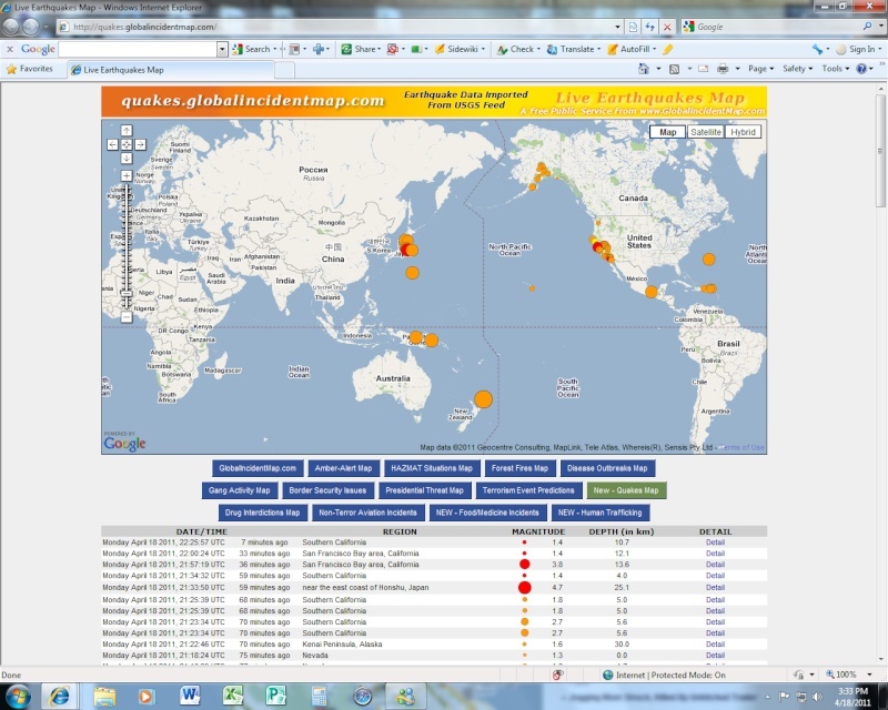
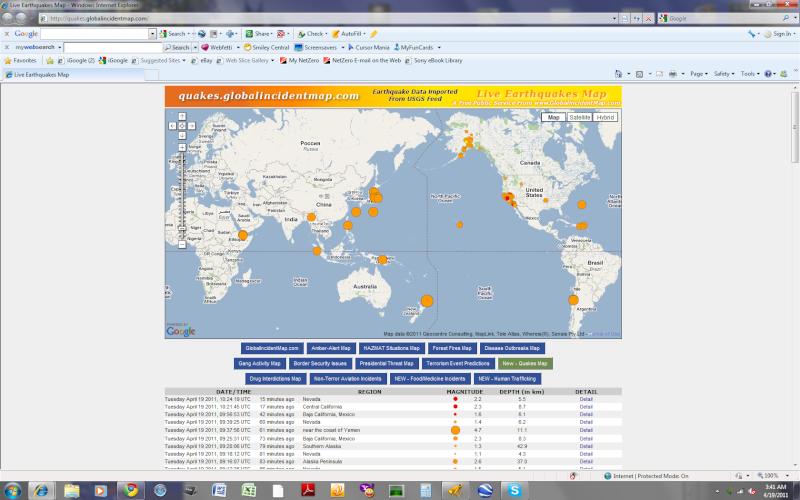
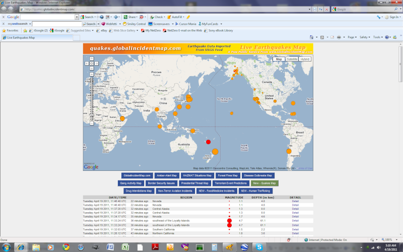
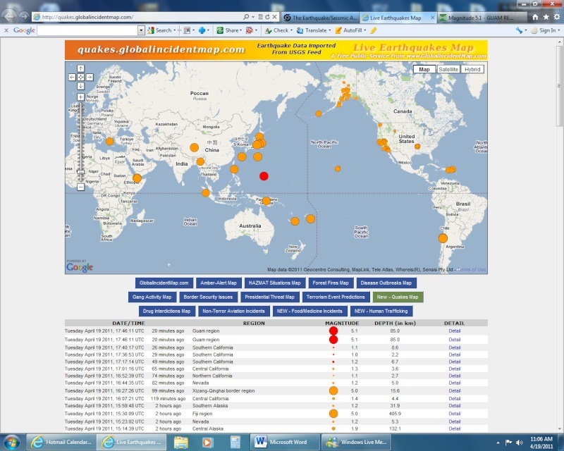
    Cal-Neva ~ Last 24 Hours -


    map 1.6 2011/04/19 20:45:01 38.358N 118.742W 9.1 20 km (12 mi) WNW of Qualeys Camp, NV
    map 1.2 2011/04/19 20:41:20 35.826N 117.531W 3.5 15 km ( 9 mi) WNW of Searles Valley, CA
    map 1.0 2011/04/19 20:41:13 37.177N 116.504W 13.0 37 km (23 mi) NE of Beatty, NV
    map 1.7 2011/04/19 20:27:06 33.289N 116.222W 10.4 15 km ( 9 mi) ENE of Borrego Springs, CA
    map 1.6 2011/04/19 20:21:32 38.813N 122.817W 2.4 2 km ( 1 mi) NNW of The Geysers, CA
    map 1.3 2011/04/19 20:04:20 35.824N 117.509W 1.4 13 km ( 8 mi) WNW of Searles Valley, CA
    map 1.2 2011/04/19 18:34:35 35.761N 116.018W 0.6 20 km (12 mi) ESE of Tecopa, CA
    map 1.1 2011/04/19 18:15:31 38.792N 122.777W 1.9 3 km ( 2 mi) ESE of The Geysers, CA
    map 2.0 2011/04/19 18:05:19 38.153N 119.000W 1.9 7 km ( 4 mi) S of Bodie, CA
    map 1.1 2011/04/19 17:24:41 38.818N 122.803W 3.2 2 km ( 1 mi) N of The Geysers, CA
    map 1.1 2011/04/19 17:05:46 33.760N 117.135W 0.0 3 km ( 2 mi) NW of Homeland, CA
    map 1.3 2011/04/19 17:00:03 35.669N 115.700W 0.3 18 km (11 mi) SSW of Sandy Valley, NV
    map 1.8 2011/04/19 16:09:27 38.494N 118.807W 0.0 16 km (10 mi) WSW of Hawthorne, NV
    map 1.3 2011/04/19 16:02:06 32.999N 116.344W 8.0 24 km (15 mi) ESE of Julian, CA
    map 1.7 2011/04/19 15:57:18 38.814N 122.793W 2.8 2 km ( 1 mi) NE of The Geysers, CA
    map 1.7 2011/04/19 15:42:47 38.440N 118.769W 0.1 16 km (10 mi) SW of Hawthorne, NV
    map 1.9 2011/04/19 15:15:17 37.602N 122.454W 12.9 4 km ( 2 mi) SE of Pacifica, CA
    map 1.5 2011/04/19 15:11:13 33.066N 114.973W 0.0 43 km (27 mi) SW of Cibola, AZ
    map 1.5 2011/04/19 14:59:28 38.363N 118.771W 1.7 22 km (14 mi) WNW of Qualeys Camp, NV
    map 1.3 2011/04/19 14:51:07 37.730N 121.981W 9.0 4 km ( 2 mi) SW of San Ramon, CA
    map 1.5 2011/04/19 14:08:09 33.978N 116.659W 8.2 11 km ( 7 mi) SW of Morongo Valley, CA
    map 1.8 2011/04/19 14:07:06 33.995N 118.535W 13.3 6 km ( 4 mi) WSW of Santa Monica, CA
    map 1.7 2011/04/19 13:45:38 33.016N 115.543W 12.2 4 km ( 3 mi) N of Brawley, CA
    map 1.4 2011/04/19 13:41:12 33.844N 117.487W 0.0 8 km ( 5 mi) ESE of Corona, CA
    map 1.1 2011/04/19 12:55:37 35.820N 117.538W 0.0 15 km ( 9 mi) WNW of Searles Valley, CA
    map 1.8 2011/04/19 12:39:19 38.343N 118.918W 8.0 17 km (10 mi) NNE of Bodie, CA
    map 1.8 2011/04/19 12:34:30 40.132N 122.108W 17.2 9 km ( 5 mi) NNE of Gerber, CA
    map 2.1 2011/04/19 12:28:20 38.475N 118.829W 0.0 16 km (10 mi) SE of Wichman, NV
    map 1.9 2011/04/19 12:22:38 38.624N 116.959W 14.4 64 km (40 mi) SSE of Washington, NV
    map 1.5 2011/04/19 12:13:36 38.792N 122.806W 3.3 1 km ( 0 mi) S of The Geysers, CA
    map 1.7 2011/04/19 11:59:57 34.651N 116.364W 3.1 20 km (13 mi) WSW of Ludlow, CA
    map 2.3 2011/04/19 11:56:47 38.821N 122.827W 2.3 3 km ( 2 mi) NW of The Geysers, CA
    map 2.8 2011/04/19 11:11:23 32.549N 115.690W 10.0 23 km (14 mi) SW of Calexico, CA
    map 1.0 2011/04/19 10:40:17 33.466N 116.430W 8.9 25 km (15 mi) ESE of Anza, CA
    map 1.1 2011/04/19 10:17:14 33.468N 116.426W 8.3 25 km (15 mi) ESE of Anza, CA
    map 1.3 2011/04/19 10:01:16 35.828N 117.534W 3.6 15 km ( 9 mi) WNW of Searles Valley, CA
    map 1.1 2011/04/19 09:52:39 38.823N 122.824W 2.7 3 km ( 2 mi) NNW of The Geysers, CA
    map 1.2 2011/04/19 09:44:35 38.432N 118.719W 5.0 13 km ( 8 mi) SW of Hawthorne, NV
    map 1.1 2011/04/19 09:07:21 36.047N 117.716W 2.6 21 km (13 mi) E of Coso Junction, CA
    map 1.2 2011/04/19 08:58:43 35.145N 118.404W 0.0 4 km ( 3 mi) ENE of Tehachapi, CA
    map 1.2 2011/04/19 08:23:02 38.370N 118.748W 5.3 20 km (13 mi) SSW of Hawthorne, NV
    map 2.0 2011/04/19 07:36:20 32.240N 115.325W 10.0 21 km (13 mi) WSW of Guadalupe Victoria, Baja California, Mexico
    map 1.5 2011/04/19 07:30:50 38.395N 118.746W 2.6 18 km (11 mi) SW of Hawthorne, NV
    map 1.8 2011/04/19 07:16:09 38.818N 122.823W 2.8 3 km ( 2 mi) NNW of The Geysers, CA
    map 1.6 2011/04/19 07:14:06 33.975N 116.820W 15.8 9 km ( 5 mi) NE of Banning, CA
    map 2.6 2011/04/19 07:06:09 33.978N 116.824W 16.8 8 km ( 5 mi) NE of Banning, CA
    map 1.1 2011/04/19 06:52:05 38.406N 118.739W 4.5 17 km (10 mi) SW of Hawthorne, NV
    map 2.5 2011/04/19 06:34:21 33.436N 119.065W 13.7 46 km (29 mi) ENE of San Nicolas Is., CA
    map 1.4 2011/04/19 06:25:28 37.488N 118.403W 9.7 14 km ( 8 mi) N of Bishop, CA
    map 1.3 2011/04/19 06:18:01 38.384N 118.762W 6.6 20 km (12 mi) SW of Hawthorne, NV
    map 1.2 2011/04/19 05:39:34 38.407N 118.736W 5.3 16 km (10 mi) SW of Hawthorne, NV
    map 1.6 2011/04/19 05:39:02 33.927N 118.284W 14.4 2 km ( 1 mi) SE of Westmont, CA
    map 2.0 2011/04/19 05:05:34 32.639N 115.740W 5.7 18 km (11 mi) SSW of Seeley, CA
    map 1.1 2011/04/19 04:46:48 38.410N 118.732W 4.8 16 km (10 mi) SW of Hawthorne, NV
    map 1.7 2011/04/19 04:34:17 38.409N 118.728W 4.6 16 km (10 mi) SW of Hawthorne, NV
    map 1.5 2011/04/19 04:32:03 32.639N 115.769W 4.0 19 km (12 mi) SSW of Seeley, CA
    map 1.0 2011/04/19 04:26:12 38.824N 122.799W 3.6 3 km ( 2 mi) NNE of The Geysers, CA
    map 1.2 2011/04/19 04:21:06 38.410N 118.725W 4.8 16 km (10 mi) SW of Hawthorne, NV
    map 1.3 2011/04/19 04:06:03 38.412N 118.732W 0.2 16 km (10 mi) SW of Hawthorne, NV
    map 2.5 2011/04/19 04:02:14 38.416N 118.733W 1.9 15 km (10 mi) SW of Hawthorne, NV
    MAP 3.1 2011/04/19 03:52:50 38.413N 118.742W 2.3 16 KM (10 MI) SW OF HAWTHORNE, NV
    map 1.0 2011/04/19 03:49:52 38.417N 118.737W 5.6 16 km (10 mi) SW of Hawthorne, NV
    map 1.0 2011/04/19 03:36:38 38.408N 118.728W 4.7 16 km (10 mi) SW of Hawthorne, NV
    map 2.7 2011/04/19 03:24:19 38.414N 118.732W 2.6 16 km (10 mi) SW of Hawthorne, NV
    map 2.2 2011/04/19 03:21:45 36.595N 121.110W 8.3 8 km ( 5 mi) NNE of Pinnacles, CA
    map 1.8 2011/04/19 02:56:44 32.266N 115.728W 10.0 49 km (31 mi) SSW of Mexicali, Baja California, Mexico
    map 1.4 2011/04/19 02:39:25 38.420N 118.739W 6.2 15 km (10 mi) SW of Hawthorne, NV
    map 2.2 2011/04/19 02:25:32 32.635N 115.733W 7.2 18 km (11 mi) SSW of Seeley, CA
    map 1.1 2011/04/19 02:18:12 38.391N 118.748W 4.3 18 km (11 mi) SW of Hawthorne, NV
    map 1.5 2011/04/19 02:12:36 38.417N 118.726W 5.1 15 km ( 9 mi) SW of Hawthorne, NV
    map 1.9 2011/04/19 02:04:00 38.410N 118.767W 1.7 18 km (11 mi) SW of Hawthorne, NV
    map 1.0 2011/04/19 01:40:19 38.417N 118.724W 0.0 15 km ( 9 mi) SW of Hawthorne, NV
    map 1.4 2011/04/19 01:32:10 38.072N 118.937W 0.1 17 km (10 mi) SSE of Bodie, CA
    map 1.3 2011/04/19 01:20:45 33.462N 116.427W 7.5 24 km (15 mi) NNW of Borrego Springs, CA
    map 1.8 2011/04/19 01:10:50 38.415N 118.723W 5.1 15 km ( 9 mi) SW of Hawthorne, NV
    map 1.4 2011/04/19 01:03:39 38.837N 122.831W 1.7 5 km ( 3 mi) NNW of The Geysers, CA
    map 1.0 2011/04/19 01:00:59 38.411N 118.734W 4.4 16 km (10 mi) SW of Hawthorne, NV
    map 1.7 2011/04/19 00:48:58 38.424N 118.793W 0.0 19 km (12 mi) SW of Hawthorne, NV
    map 1.8 2011/04/19 00:46:09 38.402N 118.740W 4.9 17 km (11 mi) SW of Hawthorne, NV
    map 2.4 2011/04/19 00:37:29 32.226N 115.347W 10.0 23 km (15 mi) WSW of Guadalupe Victoria, Baja California, Mexico
    map 1.4 2011/04/19 00:05:04 38.156N 117.150W 4.6 12 km ( 7 mi) NE of Tonopah, NV
    map 1.6 2011/04/19 00:01:50 38.407N 118.738W 5.3 17 km (10 mi) SW of Hawthorne, NV
    map 1.3 2011/04/18 23:55:19 38.838N 122.831W 2.7 5 km ( 3 mi) NNW of The Geysers, CA
    map 2.9 2011/04/18 23:47:37 38.417N 118.749W 3.3 16 km (10 mi) SW of Hawthorne, NV
    map 1.4 2011/04/18 23:35:27 34.659N 116.677W 3.6 34 km (21 mi) NE of Lucerne Valley, CA
    map 2.0 2011/04/18 23:23:13 32.592N 115.769W 2.9 23 km (15 mi) SSW of Seeley, CA
    map 2.3 2011/04/18 23:07:44 32.625N 115.729W 7.6 19 km (12 mi) S of Seeley, CA
    map 1.6 2011/04/18 22:55:12 32.994N 116.345W 8.6 24 km (15 mi) ESE of Julian, CA
    map 1.1 2011/04/18 22:01:55 38.406N 118.730W 3.6 16 km (10 mi) SW of Hawthorne, NV
    map 1.6 2011/04/18 21:18:43 38.407N 118.723W 4.8 16 km (10 mi) SSW of Hawthorne, NV

      Current date/time is Sun May 19, 2024 8:10 pm