tMoA

Would you like to react to this message? Create an account in a few clicks or log in to continue.
tMoA

~ The only Home on the Web You'll ever need ~

+21
Aquaries1111
giovonni
arvan33
Floyd
lawlessline
JesterTerrestrial
THEeXchanger
newel
Brook
greybeard
Mercuriel
Sanicle
devakas
hobbit
mudra
burgundia
lindabaker
LeeEllisMusic
MargueriteBee
Carol
HigherLove
25 posters

    The Earthquake/Seismic Activity Log

    HigherLove
    HigherLove


    Posts : 2357
    Join date : 2011-01-27
    Age : 58

    The Earthquake/Seismic Activity Log - Page 2 Empty Re: The Earthquake/Seismic Activity Log

    Post  HigherLove Sun Apr 10, 2011 8:20 pm

    map 3.0 2011/04/10 18:04:59 38.362N 118.761W 0.0 21 km (13 mi) WNW of Qualeys Camp, NV
    map 4.0 2011/04/10 17:21:16 38.374N 118.739W 15.3 20 km (12 mi) SSW of Hawthorne, NV
    map 3.5 2011/04/10 17:20:17 38.363N 118.741W 9.4 20 km (12 mi) WNW of Qualeys Camp, NV
    map 3.3 2011/04/10 17:13:11 38.337N 118.746W 10.2 19 km (12 mi) W of Qualeys Camp, NV
    map 3.5 2011/04/10 16:06:00 38.374N 118.741W 9.7 20 km (12 mi) SSW of Hawthorne, NV
    map 3.0 2011/04/10 16:02:16 38.373N 118.738W 10.1 20 km (12 mi) SSW of Hawthorne, NV
    map 3.6 2011/04/10 09:21:57 40.379N 125.421W 5.1 96 km (60 mi) W of Petrolia, CA
    map 3.2 2011/04/10 02:48:54 38.761N 122.737W 1.2 4 km ( 3 mi) WSW of Anderson Springs, CA


    <a href="https://s835.photobucket.com/albums/zz272/DSummerMan65/?action=view&current=100_3201.jpg" target="_blank"><img src="https://2img.net/h/i835.photobucket.com/albums/zz272/DSummerMan65/100_3201.jpg" border="0" width="400"></a>


    WHAT THE FRACK?
    The Geysers


    <a href="https://s835.photobucket.com/albums/zz272/DSummerMan65/?action=view&current=100_3196.jpg" target="_blank"><img src="https://2img.net/h/i835.photobucket.com/albums/zz272/DSummerMan65/100_3196.jpg" border="0" WIDTH="500"></a>


    Last edited by HigherLove on Mon Apr 11, 2011 5:53 am; edited 1 time in total
    HigherLove
    HigherLove


    Posts : 2357
    Join date : 2011-01-27
    Age : 58

    The Earthquake/Seismic Activity Log - Page 2 Empty Re: The Earthquake/Seismic Activity Log

    Post  HigherLove Sun Apr 10, 2011 9:56 pm

    MAP 5.2 2011/04/11 02:01:20 -17.766 -178.529 538.8 FIJI REGION
    MAP 5.0 2011/04/10 16:18:18 -23.611 179.821 523.1 SOUTH OF THE FIJI ISLANDS
    HigherLove
    HigherLove


    Posts : 2357
    Join date : 2011-01-27
    Age : 58

    The Earthquake/Seismic Activity Log - Page 2 Empty Re: The Earthquake/Seismic Activity Log

    Post  HigherLove Mon Apr 11, 2011 5:51 am

    Very busy day


    MAP 4.7 2011/04/11 10:00:06 36.901 140.696 16.3 NEAR THE EAST COAST OF HONSHU, JAPAN
    MAP 4.9 2011/04/11 09:36:22 36.914 140.393 15.2 NEAR THE EAST COAST OF HONSHU, JAPAN
    MAP 4.7 2011/04/11 09:30:35 37.050 140.498 12.2 EASTERN HONSHU, JAPAN
    MAP 4.8 2011/04/11 09:17:13 37.744 142.583 20.5 OFF THE EAST COAST OF HONSHU, JAPAN
    MAP 4.7 2011/04/11 09:12:34 36.906 140.440 25.1 NEAR THE EAST COAST OF HONSHU, JAPAN
    MAP 4.9 2011/04/11 09:05:22 37.041 140.566 30.1 EASTERN HONSHU, JAPAN
    MAP 3.6 2011/04/11 09:03:27 31.794 -115.899 0.2 BAJA CALIFORNIA, MEXICO
    MAP 3.1 2011/04/11 08:59:52 19.309 -155.231 9.9 ISLAND OF HAWAII, HAWAII
    MAP 5.0 2011/04/11 08:58:04 37.013 140.358 17.1 EASTERN HONSHU, JAPAN
    MAP 4.7 2011/04/11 08:33:54 36.990 140.263 24.8 NEAR THE EAST COAST OF HONSHU, JAPAN
    MAP 5.2 2011/04/11 08:26:31 37.103 140.446 15.0 EASTERN HONSHU, JAPAN
    MAP 6.6 2011/04/11 08:16:13 37.007 140.477 10.0 EASTERN HONSHU, JAPAN
    MAP 5.0 2011/04/11 07:55:10 -23.906 -66.761 191.2 JUJUY, ARGENTINA
    MAP 2.7 2011/04/11 07:20:49 36.006 -121.008 6.2 CENTRAL CALIFORNIA
    MAP 2.6 2011/04/11 05:24:48 57.383 -153.134 18.7 KODIAK ISLAND REGION, ALASKA
    MAP 3.3 2011/04/11 05:05:54 18.259 -67.984 103.1 DOMINICAN REPUBLIC REGION
    MAP 5.0 2011/04/11 04:51:46 37.539 141.210 29.1 NEAR THE EAST COAST OF HONSHU, JAPAN
    MAP 2.6 2011/04/11 04:48:08 38.386 -118.732 9.6 NEVADA
    MAP 3.8 2011/04/11 04:00:55 32.108 -115.240 2.8 BAJA CALIFORNIA, MEXICO
    MAP 2.9 2011/04/11 02:54:58 38.382 -118.731 9.4 NEVADA
    MAP 4.6 2011/04/11 02:26:36 37.738 142.409 21.6 OFF THE EAST COAST OF HONSHU, JAPAN
    MAP 5.2 2011/04/11 02:01:20 -17.766 -178.529 538.8 FIJI REGION
    MAP 3.3 2011/04/11 01:05:00 38.375 -118.739 6.0 NEVADA
    MAP 2.6 2011/04/11 00:31:09 38.305 -118.873 0.0 NEVADA
    MAP 4.2 2011/04/11 00:22:21 38.379 -118.735 13.8 NEVADA
    MAP 4.0 2011/04/11 00:21:17 38.374 -118.739 15.3 NEVADA
    MAP 3.5 2011/04/11 00:20:17 38.363 -118.741 9.4 NEVADA
    MAP 3.3 2011/04/11 00:13:12 38.337 -118.746 10.2 NEVADA
    MAP 4.7 2011/04/10 23:44:05 15.331 -59.920 23.4 EAST OF DOMINICA, LEEWARD ISLANDS
    HigherLove
    HigherLove


    Posts : 2357
    Join date : 2011-01-27
    Age : 58

    The Earthquake/Seismic Activity Log - Page 2 Empty Re: The Earthquake/Seismic Activity Log

    Post  HigherLove Mon Apr 11, 2011 7:10 am

    Magnitude 1.7
    Date-Time Sunday, April 10, 2011 at 22:22:22 UTC
    Sunday, April 10, 2011 at 03:22:22 PM at epicenter

    Location 38.815°N, 122.847°W
    Depth 0.9 km (~0.6 mile)
    Region NORTHERN CALIFORNIA
    Distances 4 km (2 miles) WNW (298°) from The Geysers, CA
    11 km (7 miles) WSW (258°) from Cobb, CA
    14 km (9 miles) WNW (288°) from Anderson Springs, CA
    15 km (9 miles) E (83°) from Cloverdale, CA
    43 km (26 miles) NNW (343°) from Santa Rosa, CA
    122 km (76 miles) NNW (342°) from San Francisco City Hall, CA

    Location Uncertainty horizontal +/- 0.2 km (0.1 miles); depth +/- 0.5 km (0.3 miles)
    Parameters Nph= 19, Dmin=2 km, Rmss=0.06 sec, Gp= 83°,
    M-type=duration magnitude (Md), Version=0
    Source California Integrated Seismic Net:
    USGS Caltech CGS UCB UCSD UNR

    Event ID nc71555811


    The last quake last night was at 22:22:22 UTC. I saw that just as I was asking myself if once again the quakes stopped before midnight, and picked up again, later.

    Zack Covell is concerned because it is an 11/11 day, and he cannot get through to HAARP's Alaska ".edu" server.

    Cow
    lindabaker
    lindabaker


    Posts : 1385
    Join date : 2010-04-15
    Location : straight ahead

    The Earthquake/Seismic Activity Log - Page 2 Empty Re: The Earthquake/Seismic Activity Log

    Post  lindabaker Mon Apr 11, 2011 7:41 am

    HigherLove wrote:

    Event ID nc71555811


    The last quake last night was at 22:22:22 UTC. I saw that just as I was asking myself if once again the quakes stopped before midnight, and picked up again, later.

    Zack Covell is concerned because it is an 11/11 day, and he cannot get through to HAARP's Alaska ".edu" server.

    Cow

    What are you saying? The quakes stop at midnight and then resume later? Is it just a lack of data stream management, or are you saying that the Man Behind The Curtain is doing a shift change at midnight? Hmmmmm....
    HigherLove
    HigherLove


    Posts : 2357
    Join date : 2011-01-27
    Age : 58

    The Earthquake/Seismic Activity Log - Page 2 Empty Re: The Earthquake/Seismic Activity Log

    Post  HigherLove Mon Apr 11, 2011 7:51 am

    lindabaker wrote:
    HigherLove wrote:

    Event ID nc71555811


    The last quake last night was at 22:22:22 UTC. I saw that just as I was asking myself if once again the quakes stopped before midnight, and picked up again, later.

    Zack Covell is concerned because it is an 11/11 day, and he cannot get through to HAARP's Alaska ".edu" server.

    Cow

    What are you saying? The quakes stop at midnight and then resume later? Is it just a lack of data stream management, or are you saying that the Man Behind The Curtain is doing a shift change at midnight? Hmmmmm....

    Merc and I concluded it is a shift change. Ironic, eh? Shift change. :op

    I have not gone backward, but since I started paying attention (and after everybody's tutelage), I noticed that there are not any quakes a midnight. Weird.
    lindabaker
    lindabaker


    Posts : 1385
    Join date : 2010-04-15
    Location : straight ahead

    The Earthquake/Seismic Activity Log - Page 2 Empty Re: The Earthquake/Seismic Activity Log

    Post  lindabaker Mon Apr 11, 2011 8:17 am

    HigherLove, do you mean midnight UTC? How bizarre. How long does it take for haarp players to change a light bulb? Anyway, you and Merc are not prone to sensationalism, so now my curiosity is piqued. Have you posted about this in another thread and I missed it? Meanwhile, back to the ring of fire watch, as I have been calling it. The new quake in S. Japan, the non aftershock one, is a bad trend for that area. I was thinking it wouldn't manifest. Thanks for keeping up the reporting from California : there are a lot of us reading, but not always giving feedback. Your photos are making me want to visit California, wow, mountains, it's my kinda place. My husband has family in Humboldt County Eureka area so we could drive the coast from LA to Seattle. Flights are cheap so maybe we'll tempt the gods he he. Besides, If it's not one thing, it's another. May as well think that way, sitting here wondering about the New Madrid effects doesn't help, right?
    HigherLove
    HigherLove


    Posts : 2357
    Join date : 2011-01-27
    Age : 58

    The Earthquake/Seismic Activity Log - Page 2 Empty Re: The Earthquake/Seismic Activity Log

    Post  HigherLove Mon Apr 11, 2011 9:07 am

    lindabaker wrote:HigherLove, do you mean midnight UTC? How bizarre. How long does it take for haarp players to change a light bulb? Anyway, you and Merc are not prone to sensationalism, so now my curiosity is piqued. Have you posted about this in another thread and I missed it? Meanwhile, back to the ring of fire watch, as I have been calling it. The new quake in S. Japan, the non aftershock one, is a bad trend for that area. I was thinking it wouldn't manifest. Thanks for keeping up the reporting from California : there are a lot of us reading, but not always giving feedback. Your photos are making me want to visit California, wow, mountains, it's my kinda place. My husband has family in Humboldt County Eureka area so we could drive the coast from LA to Seattle. Flights are cheap so maybe we'll tempt the gods he he. Besides, If it's not one thing, it's another. May as well think that way, sitting here wondering about the New Madrid effects doesn't help, right?

    Thanks!

    Midnight, here, in the geysers -

    http://www.themistsofavalon.net/t1949-remembering-who-i-am

    http://www.themistsofavalon.net/t2260-rambling-rumbling-in-northern-california

    http://www.themistsofavalon.net/t2162-earth-changes-2011-daily-updates
    HigherLove
    HigherLove


    Posts : 2357
    Join date : 2011-01-27
    Age : 58

    The Earthquake/Seismic Activity Log - Page 2 Empty Re: The Earthquake/Seismic Activity Log

    Post  HigherLove Mon Apr 11, 2011 11:08 am

    Just had a small quake in Arizona.

    Magnitude 2.1
    Date-Time Monday, April 11, 2011 at 15:45:25 UTC
    Monday, April 11, 2011 at 08:45:25 AM at epicenter

    Location 36.078°N, 114.727°W
    Depth 0 km (~0 mile) set by location program
    Region ARIZONA
    Distances 21 km (13 miles) NE (43°) from Boulder City, NV
    27 km (17 miles) E (79°) from Henderson, NV
    28 km (18 miles) E (94°) from East Las Vegas, NV
    46 km (29 miles) ESE (106°) from Las Vegas, NV

    Location Uncertainty Error estimate not available
    Parameters NST= 17, Nph= 17, Dmin=129.7 km, Rmss=0 sec, Gp=238°,
    M-type=local magnitude (ML), Version=7
    Source Seismological Laboratory, University of Nevada, Reno

    Event ID nn00332594

    The Earthquake/Seismic Activity Log - Page 2 32_42_10

    This is Mammoth Lakes area (central/east). Nevada has been getting a lot of activity. They seem to be pushing east. Is there a boundary line anymore?

    The Earthquake/Seismic Activity Log - Page 2 Indexf10

    Carol
    Carol
    Admin
    Admin


    Posts : 31744
    Join date : 2010-04-07
    Location : Hawaii

    The Earthquake/Seismic Activity Log - Page 2 Empty Re: The Earthquake/Seismic Activity Log

    Post  Carol Mon Apr 11, 2011 11:14 am

    There are so many quakes along the San Andraes Fault. rumble, rumble, rumble


    _________________
    What is life?
    It is the flash of a firefly in the night, the breath of a buffalo in the wintertime. It is the little shadow which runs across the grass and loses itself in the sunset.

    With deepest respect ~ Aloha & Mahalo, Carol
    HigherLove
    HigherLove


    Posts : 2357
    Join date : 2011-01-27
    Age : 58

    The Earthquake/Seismic Activity Log - Page 2 Empty Re: The Earthquake/Seismic Activity Log

    Post  HigherLove Mon Apr 11, 2011 5:11 pm

    Carol wrote:There are so many quakes along the San Andraes Fault. rumble, rumble, rumble

    Yep!

    ________________

    This list contains all earthquakes with magnitude greater than 2.5 located by the USGS and contributing networks in the last week (168 hours). Magnitudes 4.5 and above are in bold font. Magnitudes 6 and above are in red. (Some early events may be obscured by later ones on the maps.)

    The most recent earthquakes are at the top of the list. Times are in Coordinated Universal Time (UTC). Click on the word "map" to see a ten-degree tall map displaying the earthquake. Click on an event's "DATE" to get a detailed report.

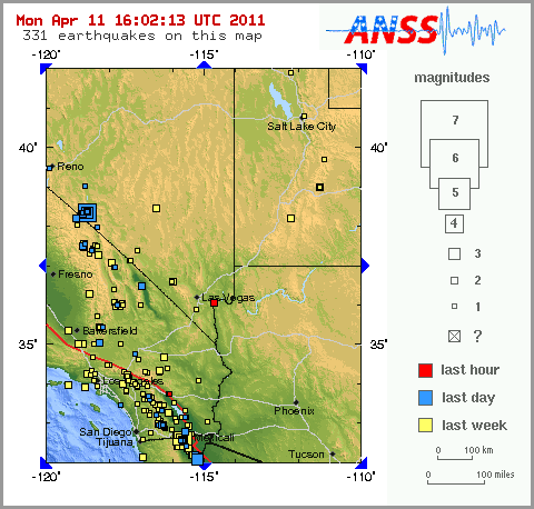
    Update time = Mon Apr 11 22:05:22 UTC 2011

    MAG UTC DATE-TIME
    y/m/d h:m:s LAT
    deg LON
    deg DEPTH
    km Region
    MAP 2.6 2011/04/11 21:28:47 59.823 -150.296 23.8 KENAI PENINSULA, ALASKA
    MAP 4.7 2011/04/11 21:21:19 38.831 141.972 58.0 NEAR THE EAST COAST OF HONSHU, JAPAN
    MAP 4.7 2011/04/11 21:03:03 36.361 145.788 15.1 OFF THE EAST COAST OF HONSHU, JAPAN
    MAP 2.8 2011/04/11 19:34:56 56.767 -156.303 47.0 ALASKA PENINSULA
    MAP 5.4 2011/04/11 17:53:31 37.630 144.527 7.4 OFF THE EAST COAST OF HONSHU, JAPAN
    MAP 4.4 2011/04/11 16:49:22 37.148 140.478 38.0 EASTERN HONSHU, JAPAN
    MAP 4.4 2011/04/11 16:19:31 36.276 140.424 10.0 NEAR THE EAST COAST OF HONSHU, JAPAN
    MAP 4.9 2011/04/11 15:58:01 37.068 140.368 43.0 EASTERN HONSHU, JAPAN
    MAP 4.4 2011/04/11 15:43:16 36.847 140.582 20.5 NEAR THE EAST COAST OF HONSHU, JAPAN
    MAP 4.8 2011/04/11 15:21:44 36.923 140.256 37.9 NEAR THE EAST COAST OF HONSHU, JAPAN
    MAP 4.5 2011/04/11 15:08:09 37.636 142.570 36.8 OFF THE EAST COAST OF HONSHU, JAPAN
    MAP 2.8 2011/04/11 15:06:39 61.604 -150.132 19.9 SOUTHERN ALASKA
    MAP 4.8 2011/04/11 14:23:47 -5.395 154.210 173.3 BOUGAINVILLE REGION, PAPUA NEW GUINEA
    MAP 4.4 2011/04/11 14:08:51 36.935 140.695 26.2 NEAR THE EAST COAST OF HONSHU, JAPAN
    MAP 2.6 2011/04/11 14:03:30 35.068 -118.335 6.3 SOUTHERN CALIFORNIA
    MAP 4.2 2011/04/11 14:02:06 36.889 140.755 13.3 NEAR THE EAST COAST OF HONSHU, JAPAN
    MAP 5.0 2011/04/11 13:33:42 -29.601 -177.357 37.7 KERMADEC ISLANDS, NEW ZEALAND
    MAP 4.5 2011/04/11 13:24:09 38.159 142.353 5.1 NEAR THE EAST COAST OF HONSHU, JAPAN
    MAP 4.8 2011/04/11 13:05:43 37.103 140.465 25.9 EASTERN HONSHU, JAPAN
    MAP 2.9 2011/04/11 13:02:12 32.998 -116.356 7.7 SOUTHERN CALIFORNIA
    MAP 3.7 2011/04/11 12:36:45 31.672 -115.981 9.1 BAJA CALIFORNIA, MEXICO
    MAP 5.6 2011/04/11 11:42:36 36.969 140.454 13.8 NEAR THE EAST COAST OF HONSHU, JAPAN
    MAP 4.7 2011/04/11 11:27:33 37.141 140.644 22.0 EASTERN HONSHU, JAPAN
    MAP 3.0 2011/04/11 10:53:29 19.588 -67.856 71.4 DOMINICAN REPUBLIC REGION
    MAP 4.7 2011/04/11 10:00:06 36.901 140.696 16.3 NEAR THE EAST COAST OF HONSHU, JAPAN
    MAP 4.9 2011/04/11 09:36:22 36.914 140.393 15.2 NEAR THE EAST COAST OF HONSHU, JAPAN
    MAP 4.7 2011/04/11 09:30:35 37.050 140.498 12.2 EASTERN HONSHU, JAPAN
    MAP 4.8 2011/04/11 09:17:13 37.744 142.583 20.5 OFF THE EAST COAST OF HONSHU, JAPAN
    MAP 4.7 2011/04/11 09:12:34 36.906 140.440 25.1 NEAR THE EAST COAST OF HONSHU, JAPAN
    MAP 4.9 2011/04/11 09:05:22 37.041 140.566 30.1 EASTERN HONSHU, JAPAN
    MAP 3.6 2011/04/11 09:03:27 31.794 -115.899 0.2 BAJA CALIFORNIA, MEXICO
    MAP 2.9 2011/04/11 08:59:52 19.287 -155.234 8.4 ISLAND OF HAWAII, HAWAII
    MAP 5.0 2011/04/11 08:58:04 37.013 140.358 17.1 EASTERN HONSHU, JAPAN
    MAP 4.7 2011/04/11 08:33:54 36.990 140.263 24.8 NEAR THE EAST COAST OF HONSHU, JAPAN
    MAP 5.2 2011/04/11 08:26:31 37.103 140.446 15.0 EASTERN HONSHU, JAPAN
    MAP 6.6 2011/04/11 08:16:13 37.007 140.477 10.0 EASTERN HONSHU, JAPAN
    MAP 5.0 2011/04/11 07:55:10 -23.906 -66.761 191.2 JUJUY, ARGENTINA
    MAP 2.7 2011/04/11 07:20:49 36.006 -121.008 6.2 CENTRAL CALIFORNIA
    MAP 2.6 2011/04/11 05:24:48 57.383 -153.134 18.7 KODIAK ISLAND REGION, ALASKA
    MAP 3.3 2011/04/11 05:05:54 18.259 -67.984 103.1 DOMINICAN REPUBLIC REGION
    MAP 5.0 2011/04/11 04:51:46 37.539 141.210 29.1 NEAR THE EAST COAST OF HONSHU, JAPAN
    MAP 2.6 2011/04/11 04:48:08 38.386 -118.732 9.6 NEVADA
    MAP 3.8 2011/04/11 04:00:56 32.152 -115.245 6.1 BAJA CALIFORNIA, MEXICO
    MAP 2.9 2011/04/11 02:54:58 38.382 -118.731 9.4 NEVADA
    MAP 4.6 2011/04/11 02:26:36 37.738 142.409 21.6 OFF THE EAST COAST OF HONSHU, JAPAN
    MAP 5.2 2011/04/11 02:01:20 -17.766 -178.529 538.8 FIJI REGION
    MAP 3.3 2011/04/11 01:05:00 38.375 -118.739 6.0 NEVADA
    MAP 2.6 2011/04/11 00:31:09 38.305 -118.873 0.0 NEVADA
    MAP 4.2 2011/04/11 00:22:21 38.379 -118.735 13.8 NEVADA
    MAP 4.0 2011/04/11 00:21:17 38.374 -118.739 15.3 NEVADA
    MAP 3.5 2011/04/11 00:20:17 38.363 -118.741 9.4 NEVADA
    MAP 3.3 2011/04/11 00:13:12 38.337 -118.746 10.2 NEVADA

    http://earthquake.usgs.gov/earthquakes/recenteqsww/Quakes/quakes_all.php
    HigherLove
    HigherLove


    Posts : 2357
    Join date : 2011-01-27
    Age : 58

    The Earthquake/Seismic Activity Log - Page 2 Empty Re: The Earthquake/Seismic Activity Log

    Post  HigherLove Tue Apr 12, 2011 2:56 pm

    HigherLove wrote:
    lindabaker wrote:HigherLove, do you mean midnight UTC? How bizarre. How long does it take for haarp players to change a light bulb? Anyway, you and Merc are not prone to sensationalism, so now my curiosity is piqued. Have you posted about this in another thread and I missed it? Meanwhile, back to the ring of fire watch, as I have been calling it. The new quake in S. Japan, the non aftershock one, is a bad trend for that area. I was thinking it wouldn't manifest. Thanks for keeping up the reporting from California : there are a lot of us reading, but not always giving feedback. Your photos are making me want to visit California, wow, mountains, it's my kinda place. My husband has family in Humboldt County Eureka area so we could drive the coast from LA to Seattle. Flights are cheap so maybe we'll tempt the gods he he. Besides, If it's not one thing, it's another. May as well think that way, sitting here wondering about the New Madrid effects doesn't help, right?

    Thanks!

    Midnight, here, in the geysers -

    http://www.themistsofavalon.net/t1949-remembering-who-i-am

    http://www.themistsofavalon.net/t2260-rambling-rumbling-in-northern-california

    http://www.themistsofavalon.net/t2162-earth-changes-2011-daily-updates

    1.1 4/12/2011 10:57:54 38.823N 122.828W 1.6 3 km ( 2 mi) NW of The Geysers, CA
    2.4 4/12/2011 8:51:08 38.815N 122.818W 1.4 2 km ( 1 mi) NNW of The Geysers, CA
    1.1 4/12/2011 6:45:14 38.811N 122.828W 3.3 2 km ( 1 mi) NW of The Geysers, CA
    1.7 4/12/2011 5:58:23 38.791N 122.779W 3.7 3 km ( 2 mi) ESE of The Geysers, CA
    1.8 4/12/2011 5:23:47 38.832N 122.792W 2.7 4 km ( 2 mi) NNE of The Geysers, CA
    1.0 4/11/2011 21:30:2738.822N 122.794W 3.3 3 km ( 2 mi) NNE of The Geysers, CA


    Again: stopped before midnght (way before, this time). Did not resume until 5:23 A.M. This is the longest gap I have seen since I started checking a couple of months ago.

    Overall activity seems to be down here and worldwide.

    I'm feeling a bit restless. Sometimes this happens before quakes, and sometimes it is just my quirky moods. :op That still begs the question: why are my moods quirky. Nature/nurture? Another thread!

    Nah

    :op
    burgundia
    burgundia


    Posts : 5520
    Join date : 2010-04-09
    Location : Poland

    The Earthquake/Seismic Activity Log - Page 2 Empty Re: The Earthquake/Seismic Activity Log

    Post  burgundia Tue Apr 12, 2011 3:01 pm

    My heart has been racing for the second consecutive day and I have had sleeping problems for months now...but it is the wrong thread to post that...
    lindabaker
    lindabaker


    Posts : 1385
    Join date : 2010-04-15
    Location : straight ahead

    The Earthquake/Seismic Activity Log - Page 2 Empty Re: The Earthquake/Seismic Activity Log

    Post  lindabaker Tue Apr 12, 2011 3:07 pm

    Not necessarily, Burgundia. We all have abilities to feel something coming, and it is not inappropriate to post about it. Seven days before the Japan 9.1, I was restless, heart racing, unable to "put my finger on it." I dreamed of a four story high wave of water filled with wood debris and it was in spectacular color. I just did not know when, or where. Sometimes it is good to share so we get an idea of how our higher selves are speaking to us. Linda
    HigherLove
    HigherLove


    Posts : 2357
    Join date : 2011-01-27
    Age : 58

    The Earthquake/Seismic Activity Log - Page 2 Empty Re: The Earthquake/Seismic Activity Log

    Post  HigherLove Tue Apr 12, 2011 5:42 pm

    lindabaker wrote:Not necessarily, Burgundia. We all have abilities to feel something coming, and it is not inappropriate to post about it. Seven days before the Japan 9.1, I was restless, heart racing, unable to "put my finger on it." I dreamed of a four story high wave of water filled with wood debris and it was in spectacular color. I just did not know when, or where. Sometimes it is good to share so we get an idea of how our higher selves are speaking to us. Linda

    Yep yep

    Wink
    HigherLove
    HigherLove


    Posts : 2357
    Join date : 2011-01-27
    Age : 58

    The Earthquake/Seismic Activity Log - Page 2 Empty Re: The Earthquake/Seismic Activity Log

    Post  HigherLove Tue Apr 12, 2011 5:45 pm


    MAP 2.6 4/12/2011 22:13 61.251 -146.98 15.2 SOUTHERN ALASKA
    MAP 4.9 4/12/2011 21:52 36.329 141.893 29.9 NEAR THE EAST COAST OF HONSHU, JAPAN
    MAP 4.8 4/12/2011 21:44 -23.859 -66.672 190.7 JUJUY, ARGENTINA
    MAP 5.0 4/12/2011 21:07 13.386 145.674 23.1 GUAM REGION
    MAP 2.7 4/12/2011 20:13 59.785 -153.493 127.2 SOUTHERN ALASKA
    MAP 5.8 4/12/2011 19:37 39.43 141.82 44.8 EASTERN HONSHU, JAPAN
    MAP 2.8 4/12/2011 19:23 60.135 -152.902 123 SOUTHERN ALASKA
    MAP 4.6 4/12/2011 19:02 37.112 140.449 45.6 EASTERN HONSHU, JAPAN
    MAP 2.5 4/12/2011 17:57 32.156 -115.239 9.3 BAJA CALIFORNIA, MEXICO
    MAP 3.4 4/12/2011 15:52 31.895 -114.893 10 SONORA, MEXICO
    MAP 4.6 4/12/2011 14:03 45.221 150.754 75.1 KURIL ISLANDS
    MAP 2.9 4/12/2011 13:27 18.224 -65.344 2 PUERTO RICO REGION
    MAP 4.5 4/12/2011 13:21 9.686 -104.019 10 NORTHERN EAST PACIFIC RISE
    MAP 4.2 4/12/2011 12:03 30.628 96.926 45.5 EASTERN XIZANG
    MAP 4.8 4/12/2011 10:15 37.247 140.634 10.1 EASTERN HONSHU, JAPAN
    MAP 2.9 4/12/2011 10:15 18.932 -65.073 29.9 VIRGIN ISLANDS REGION
    MAP 3.2 4/12/2011 9:57 18.898 -65.134 10.3 VIRGIN ISLANDS REGION
    MAP 3.2 4/12/2011 9:39 18.882 -65.082 47 VIRGIN ISLANDS REGION
    MAP 4.9 4/12/2011 8:48 37.065 140.484 15.2 EASTERN HONSHU, JAPAN
    MAP 2.5 4/12/2011 8:25 58.115 -153.183 41.1 KODIAK ISLAND REGION, ALASKA
    MAP 4.8 4/12/2011 7:44 5.308 -82.619 10 SOUTH OF PANAMA
    MAP 4.6 4/12/2011 7:42 36.871 141.489 25.7 NEAR THE EAST COAST OF HONSHU, JAPAN
    MAP 4.7 4/12/2011 7:15 36.795 138.273 13.1 EASTERN HONSHU, JAPAN
    MAP 2.7 4/12/2011 6:11 37.772 -113.116 1.1 UTAH
    MAP 4.7 4/12/2011 5:26 37.061 140.762 9.6 EASTERN HONSHU, JAPAN
    MAP 6.0 4/12/2011 5:07 37 140.7 10.6 EASTERN HONSHU, JAPAN
    MAP 4.7 4/12/2011 2:13 36.954 140.374 67.5 NEAR THE EAST COAST OF HONSHU, JAPAN
    MAP 4.3 4/12/2011 1:12 42.321 -126.966 10 OFF THE COAST OF OREGON
    MAP 4.7 4/12/2011 1:08 39.967 143.627 38.8 OFF THE EAST COAST OF HONSHU, JAPAN
    MAP 2.6 4/12/2011 0:35 61.429 -146.48 19.9 SOUTHERN ALASKA


    http://earthquake.usgs.gov/earthquakes/recenteqsww/Quakes/quakes_all.php
    HigherLove
    HigherLove


    Posts : 2357
    Join date : 2011-01-27
    Age : 58

    The Earthquake/Seismic Activity Log - Page 2 Empty Re: The Earthquake/Seismic Activity Log

    Post  HigherLove Tue Apr 12, 2011 5:48 pm

    burgundia wrote:My heart has been racing for the second consecutive day and I have had sleeping problems for months now...but it is the wrong thread to post that...

    And Kudos! to all who pegged April 7th as such a busy day. Looking for quakes was like fishing out of a barrel.

    Something is up...

    Crazy Happy
    HigherLove
    HigherLove


    Posts : 2357
    Join date : 2011-01-27
    Age : 58

    The Earthquake/Seismic Activity Log - Page 2 Empty Re: The Earthquake/Seismic Activity Log

    Post  HigherLove Wed Apr 13, 2011 12:19 am

    MAP 2.9 2011/04/13 04:54:35 36.771 -121.281 8.5 CENTRAL CALIFORNIA
    MAP 3.1 2011/04/13 04:37:10 32.227 -115.368 29.6 BAJA CALIFORNIA, MEXICO
    MAP 5.3 2011/04/13 04:28:58 18.782 -64.306 41.3 VIRGIN ISLANDS REGION
    MAP 4.9 2011/04/13 04:18:33 -5.249 151.392 114.7 NEW BRITAIN REGION, PAPUA NEW GUINEA
    MAP 2.8 2011/04/13 02:08:10 60.679 -152.129 90.7 SOUTHERN ALASKA
    MAP 2.5 2011/04/13 01:57:03 38.220 -116.371 0.0 NEVADA
    MAP 5.0 2011/04/13 01:51:45 -12.639 166.439 94.7 SANTA CRUZ ISLANDS
    MAP 5.4 2011/04/13 01:08:01 36.950 140.430 24.7 NEAR THE EAST COAST OF HONSHU, JAPAN

    _____________

    My apologies for the Photobucket issues and my images. Hopefully they will be back up soon.I will make sure to upload as much as possible directly to this site. I just need to learn some features. I was just starting to master HTML when it became obsolete. Embarassed
    HigherLove
    HigherLove


    Posts : 2357
    Join date : 2011-01-27
    Age : 58

    The Earthquake/Seismic Activity Log - Page 2 Empty Re: The Earthquake/Seismic Activity Log

    Post  HigherLove Wed Apr 13, 2011 8:42 am

    Picking up from last night - (Photobucket supposed to be up and running in a couple of hours, but they are in their second day of being down).

    MAP 4.9 2011/04/13 12:51:24 -17.704 176.357 30.6 FIJI REGION
    MAP 4.6 2011/04/13 12:05:37 38.018 143.049 34.9 OFF THE EAST COAST OF HONSHU, JAPAN
    MAP 3.0 2011/04/13 11:10:34 63.940 -148.835 3.6 CENTRAL ALASKA
    MAP 4.7 2011/04/13 11:03:46 4.894 -82.547 10.1 SOUTH OF PANAMA
    MAP 4.7 2011/04/13 09:57:00 -4.664 126.642 390.6 BANDA SEA
    MAP 2.9 2011/04/13 09:26:26 18.835 -64.207 40.6 VIRGIN ISLANDS REGION
    MAP 4.5 2011/04/13 09:06:19 40.817 142.087 51.5 NEAR THE EAST COAST OF HONSHU, JAPAN
    MAP 4.4 2011/04/13 08:26:02 38.627 141.956 10.3 NEAR THE EAST COAST OF HONSHU, JAPAN
    MAP 4.5 2011/04/13 07:32:36 39.540 141.384 10.2 EASTERN HONSHU, JAPAN
    MAP 2.6 2011/04/13 07:16:48 32.216 -115.371 13.1 BAJA CALIFORNIA, MEXICO
    MAP 2.6 2011/04/13 06:50:31 18.499 -64.109 13.0 VIRGIN ISLANDS REGION
    MAP 3.1 2011/04/13 06:04:20 19.018 -64.394 21.7 VIRGIN ISLANDS REGION
    MAP 3.2 2011/04/13 05:49:44 18.518 -64.046 14.6 VIRGIN ISLANDS REGION
    MAP 3.1 2011/04/13 05:48:25 18.502 -64.198 80.9 VIRGIN ISLANDS REGION
    MAP 4.7 2011/04/13 05:41:06 37.025 142.352 34.8 OFF THE EAST COAST OF HONSHU, JAPAN
    MAP 3.2 2011/04/13 05:15:53 18.781 -64.186 42.7 VIRGIN ISLANDS REGION
    HigherLove
    HigherLove


    Posts : 2357
    Join date : 2011-01-27
    Age : 58

    The Earthquake/Seismic Activity Log - Page 2 Empty Re: The Earthquake/Seismic Activity Log

    Post  HigherLove Wed Apr 13, 2011 2:12 pm

    MAP 3.0 4/13/2011 17:53 32.069 -115.168 10 BAJA CALIFORNIA, MEXICO
    MAP 4.4 4/13/2011 15:54 36.66 141.783 40.3 NEAR THE EAST COAST OF HONSHU, JAPAN
    MAP 2.5 4/13/2011 15:49 61.307 -151.61 73.8 SOUTHERN ALASKA
    MAP 5.1 4/13/2011 15:14 -33.758 -71.85 35.1 OFFSHORE VALPARAISO, CHILE
    MAP 4.4 4/13/2011 13:29 38.715 142.875 51.1 NEAR THE EAST COAST OF HONSHU, JAPAN
    HigherLove
    HigherLove


    Posts : 2357
    Join date : 2011-01-27
    Age : 58

    The Earthquake/Seismic Activity Log - Page 2 Empty Re: The Earthquake/Seismic Activity Log

    Post  HigherLove Thu Apr 14, 2011 6:56 am

    Recent serious activity limited to Japan. Not news, I guess...
    HigherLove
    HigherLove


    Posts : 2357
    Join date : 2011-01-27
    Age : 58

    The Earthquake/Seismic Activity Log - Page 2 Empty Re: The Earthquake/Seismic Activity Log

    Post  HigherLove Thu Apr 14, 2011 12:58 pm

    MAP 5.1 4/14/2011 16:11 5.884 126.233 143.3 MINDANAO, PHILIPPINES
    MAP 4.5 4/14/2011 15:52 75.388 8.002 14.2 GREENLAND SEA

    MAP 3.2 4/14/2011 15:21 19.232 -155.414 37 ISLAND OF HAWAII, HAWAII
    MAP 2.6 4/14/2011 14:59 38.39 -118.728 14.4 NEVADA
    MAP 3.1 4/14/2011 12:05 38.381 -118.748 13.5 NEVADA
    MAP 2.9 4/14/2011 11:58 60.174 -153.468 165 SOUTHERN ALASKA
    MAP 3.0 4/14/2011 11:58 38.38 -118.746 13.9 NEVADA
    MAP 5.1 4/14/2011 10:32 39.717 143.38 29.5 OFF THE EAST COAST OF HONSHU, JAPAN
    MAP 2.8 4/14/2011 10:28 62.968 -151.024 118.5 CENTRAL ALASKA
    MAP 4.6 4/14/2011 8:47 36.56 141.804 54.9 NEAR THE EAST COAST OF HONSHU, JAPAN
    MAP 2.9 4/14/2011 6:19 32.708 -116.035 6.6 SOUTHERN CALIFORNIA
    MAP 3.3 4/14/2011 6:16 18.946 -64.318 36.5 VIRGIN ISLANDS REGION
    MAP 5.7 4/14/2011 6:08 35.675 141.873 14.4 NEAR THE EAST COAST OF HONSHU, JAPAN
    MAP 5.0 4/14/2011 6:07 36.718 141.523 44.1 NEAR THE EAST COAST OF HONSHU, JAPAN
    MAP 3.1 4/14/2011 6:01 32.054 -115.248 12.6 BAJA CALIFORNIA, MEXICO
    MAP 2.6 4/14/2011 5:55 38.797 -122.739 2.1 NORTHERN CALIFORNIA
    MAP 2.9 4/14/2011 5:48 33.21 -115.575 2.6 SOUTHERN CALIFORNIA
    MAP 5.7 4/14/2011 5:45 -32.963 -178.574 24.2 SOUTH OF THE KERMADEC ISLANDS
    MAP 4.8 4/14/2011 4:46 40.004 142.572 20.3 NEAR THE EAST COAST OF HONSHU, JAPAN
    MAP 4.1 4/14/2011 4:13 36.058 142.269 33.2 OFF THE EAST COAST OF HONSHU, JAPAN
    MAP 3.4 4/14/2011 4:03 18.973 -64.365 31.5 VIRGIN ISLANDS REGION
    MAP 5.4 4/14/2011 3:09 37.064 140.683 23.8 EASTERN HONSHU, JAPAN
    MAP 2.8 4/14/2011 2:28 38.387 -118.734 16 NEVADA
    MAP 4.4 4/14/2011 1:56 12.845 -87.927 82.1 NEAR THE COAST OF NICARAGUA
    MAP 4.3 4/14/2011 1:34 40.746 -126.434 7.5 OFF THE COAST OF NORTHERN CALIFORNIA
    MAP 4.7 4/14/2011 1:33 40.118 142.792 44.4 NEAR THE EAST COAST OF HONSHU, JAPAN
    MAP 2.7 4/14/2011 1:21 60.308 -153.048 123.6 SOUTHERN ALASKA


    Magnitude
    5.1
    Date-Time
    Thursday, April 14, 2011 at 16:11:53 UTC
    Friday, April 15, 2011 at 12:11:53 AM at epicenter
    Time of Earthquake in other Time Zones
    Location
    5.884°N, 126.233°E
    Depth 143.3 km (89.0 miles)
    Region MINDANAO, PHILIPPINES
    Distances
    119 km (73 miles) ESE of General Santos, Mindanao, Philippines
    148 km (91 miles) SSE of Davao, Mindanao, Philippines
    928 km (576 miles) W of KOROR, Palau
    1123 km (697 miles) SSE of MANILA, Philippines
    Location Uncertainty
    horizontal +/- 14.6 km (9.1 miles); depth +/- 7.9 km (4.9 miles)
    Parameters
    NST=156, Nph=173, Dmin=150.3 km, Rmss=0.97 sec, Gp= 61°,
    M-type=body wave magnitude (Mb), Version=9
    Source
    USGS NEIC (WDCS-D)
    Event ID

    usc0002r18


    Magnitude 4.5
    Date-Time Thursday, April 14, 2011 at 15:52:06 UTC
    Thursday, April 14, 2011 at 04:52:06 PM at epicenter
    Time of Earthquake in other Time Zones
    Location 75.388°N, 8.002°E
    Depth 14.2 km (8.8 miles)
    Region GREENLAND SEA
    Distances
    730 km (453 miles) NW of Hammerfest, Norway
    734 km (456 miles) NNW of Tromso, Norway
    876 km (544 miles) NNW of Kautokeino, Norway
    1668 km (1036 miles) NNE of REYKJAVIK, Iceland
    Location Uncertainty
    horizontal +/- 16.6 km (10.3 miles); depth +/- 7.1 km (4.4 miles)
    Parameters
    NST= 76, Nph= 77, Dmin=378.5 km, Rmss=0.97 sec, Gp= 79°,
    M-type=body wave magnitude (Mb), Version=7

    Source

    USGS NEIC (WDCS-D)

    Event ID

    usc0002r0s
    HigherLove
    HigherLove


    Posts : 2357
    Join date : 2011-01-27
    Age : 58

    The Earthquake/Seismic Activity Log - Page 2 Empty Re: The Earthquake/Seismic Activity Log

    Post  HigherLove Thu Apr 14, 2011 4:28 pm

    Magnitude 5.9
    Date-Time
    Thursday, April 14, 2011 at 20:50:19 UTC
    Thursday, April 14, 2011 at 02:50:19 PM at epicenter
    Time of Earthquake in other Time Zones
    Location
    11.313°N, 86.254°W
    Depth
    51.2 km (34.9 miles)
    Region
    NEAR THE COAST OF NICARAGUA
    Distances
    47 km (29 miles) WSW of Rivas, Nicaragua
    76 km (47 miles) SSW of Granada, Nicaragua
    93 km (57 miles) S of MANAGUA, Nicaragua
    1650 km (1025 miles) ESE of MEXICO CITY, D.F., Mexico
    Location Uncertainty
    horizontal +/- 19.9 km (12.4 miles); depth +/- 8.5 km (5.3 miles)
    Parameters
    NST=333, Nph=354, Dmin=181.5 km, Rmss=1.21 sec, Gp=133°,
    M-type=regional moment magnitude (Mw), Version=7
    Source
    USGS NEIC (WDCS-D)
    Event ID
    usc0002rdx


    The Earthquake/Seismic Activity Log - Page 2 270_1010
    Cosco Plate


    Last edited by HigherLove on Thu Apr 14, 2011 6:21 pm; edited 1 time in total
    HigherLove
    HigherLove


    Posts : 2357
    Join date : 2011-01-27
    Age : 58

    The Earthquake/Seismic Activity Log - Page 2 Empty Re: The Earthquake/Seismic Activity Log

    Post  HigherLove Thu Apr 14, 2011 6:05 pm

    Magnitude 2.5
    Date-Time
    Thursday, April 14, 2011 at 22:27:51 UTC
    Thursday, April 14, 2011 at 03:27:51 PM at epicenter
    Time of Earthquake in other Time Zones
    Location
    46.061°N, 122.151°W
    Depth
    9.8 km (6.1 miles) set by location program
    Region

    WASHINGTON
    Distances

    16 km (10 miles) S (172°) from Mount St. Helens Volcano, WA
    29 km (18 miles) NE (42°) from Yacolt, WA
    30 km (19 miles) NE (54°) from Amboy, WA
    59 km (37 miles) NE (36°) from Vancouver, WA

    Location Uncertainty
    horizontal +/- 0.9 km (0.6 miles); depth fixed by location program
    Parameters
    NST= 12, Nph= 12, Dmin=6 km, Rmss=0.13 sec, Gp=176°,
    M-type=duration magnitude (Md), Version=0
    Source
    Pacific Northwest Seismograph Network
    Event ID

    uw04142227


    The Earthquake/Seismic Activity Log - Page 2 Pac_nw10
    ___________________
    Magnitude 4.7
    Date-Time
    Thursday, April 14, 2011 at 22:12:51 UTC
    Friday, April 15, 2011 at 07:12:51 AM at epicenter
    Time of Earthquake in other Time Zones
    Location 3.320°S, 131.449°E
    Depth
    36.2 km (22.5 miles)
    Region
    CERAM SEA, INDONESIA
    Distances
    271 km (168 miles) S of Sorong, Papua, Indonesia
    365 km (226 miles) E of Ambon, Moluccas, Indonesia
    871 km (541 miles) NE of DILI, Timor-Leste
    1014 km (630 miles) N of DARWIN, Northern Territory, Australia
    Location Uncertainty
    horizontal +/- 19.7 km (12.2 miles); depth +/- 10.2 km (6.3 miles)
    Parameters
    NST= 42, Nph= 42, Dmin=>999 km, Rmss=0.4 sec, Gp= 72°,
    M-type=body wave magnitude (Mb), Version=5
    Source
    USGS NEIC (WDCS-D)
    Event ID

    usc0002ric
    HigherLove
    HigherLove


    Posts : 2357
    Join date : 2011-01-27
    Age : 58

    The Earthquake/Seismic Activity Log - Page 2 Empty Re: The Earthquake/Seismic Activity Log

    Post  HigherLove Thu Apr 14, 2011 6:19 pm

    http://earthquake-report.com/2011/04/14/very-strong-earthquake-at-an-intermediate-depth-near-the-coast-of-nicaragua/

    UPDATE 22:09 UTC : After reviewing our many sources, we can conclude that NO damage of Injuries have been reported from this very strong but deep earthquake.

    UPDATE 22:09 UTC : After reviewing the PTWC data, we could not find any tsunami notice.

    UPDATE 22:06 UTC : Following local media the Nicaraguan Seismological institute reported a Richter magnitude of 5.1 and vigilance for a possible tsunami. Curious as with a limited magnitude and the reported depth normal tsunami conditions are NOT present. NOAA has NOT published a tsunami bulletin for this earthquake. The location of the epicenter on top of the subduction zone is another reason that even with a higher magnitude, a tsunami would not be likely.

      Current date/time is Tue May 07, 2024 11:08 pm