tMoA

Would you like to react to this message? Create an account in a few clicks or log in to continue.
tMoA

~ The only Home on the Web You'll ever need ~

+21
Aquaries1111
giovonni
arvan33
Floyd
lawlessline
JesterTerrestrial
THEeXchanger
newel
Brook
greybeard
Mercuriel
Sanicle
devakas
hobbit
mudra
burgundia
lindabaker
LeeEllisMusic
MargueriteBee
Carol
HigherLove
25 posters

    The Earthquake/Seismic Activity Log

    HigherLove
    HigherLove


    Posts : 2357
    Join date : 2011-01-27
    Age : 58

    The Earthquake/Seismic Activity Log - Page 19 Empty Re: The Earthquake/Seismic Activity Log

    Post  HigherLove Thu Oct 20, 2011 5:07 pm

    Magnitude
    3.9 (upgraded to a 4.0)
    Date-Time
    Thursday, October 20, 2011 at 21:41:04 UTC
    Thursday, October 20, 2011 at 02:41:04 PM at epicenter
    Location
    37.864°N, 122.249°W
    Depth
    9.8 km (6.1 miles)
    Region
    SAN FRANCISCO BAY AREA, CALIFORNIA
    Distances
    2 km (2 miles) ESE (112°) from Berkeley, CA
    5 km (3 miles) NE (47°) from Emeryville, CA
    5 km (3 miles) NNW (341°) from Piedmont, CA
    8 km (5 miles) NNW (346°) from Oakland, CA
    Location Uncertainty
    horizontal +/- 0.2 km (0.1 miles); depth +/- 0.4 km (0.2 miles)
    Parameters
    Nph= 90, Dmin=2 km, Rmss=0.18 sec, Gp= 22°,
    M-type=regional moment magnitude (Mw), Version=5
    Source
    California Integrated Seismic Net:
    USGS Caltech CGS UCB UCSD UNR
    Event ID
    nc71667366

    ON THE HAYWARD FAULT

    The Earthquake/Seismic Activity Log - Page 19 122-3811

    HigherLove
    HigherLove


    Posts : 2357
    Join date : 2011-01-27
    Age : 58

    The Earthquake/Seismic Activity Log - Page 19 Empty Re: The Earthquake/Seismic Activity Log

    Post  HigherLove Thu Oct 20, 2011 6:22 pm

    A magnitude 4.0 quake jolted the Bay Area Thursday at 2:41 p.m., only hours after millions of California residents had participated in one of the biggest earthquake drills in history.

    The quake initially measured as a magnitude 3.9 earthquake, but the USGS later revised the measurement to magnitude 4.0.

    The epicenter of the quake hit two miles east-southeast of Berkeley, according to the U.S. Geological Survey.
    The temblor created a large jolt in San Francisco's Civic Center area and was felt in parts of the region including Alamo.

    There were no immediate reports of damages.

    An aftershock measuring magnitude 1.8 struck the same epicenter at 3: 09 p.m.

    The jolt was felt almost 22 years to the day after the Loma Prieta earthquake struck the Bay Area during the 1989 World Series. And it occurred on the same day that more than 8.5 million people signed up to participate in an annual earthquake drill in which people duck under desks and tables.

    All BART trains were halted or slowed due to the earthquake, a BART employee said.

    Trains systemwide are stopped or are traveling slowly as train operators conduct track inspections, the employee said.

    BART did not have an estimate for when the trains would resume normal operations.

    http://www.ktvu.com/news/29543713/detail.html

    The Earthquake/Seismic Activity Log - Page 19 28339210

    THE NEXT GREAT QUAKE: SEGMENT 1: http://www.ktvu.com/video/29453612/index.html

    THE NEXT GREAT QUAKE: SEGMENT 2: http://www.ktvu.com/video/29453908/index.html

    KTVU EARTHQUAKE SURVIVAL GUIDE: http://www.ktvu.com/quakeauthority/index.html
    Carol
    Carol
    Admin
    Admin


    Posts : 31800
    Join date : 2010-04-07
    Location : Hawaii

    The Earthquake/Seismic Activity Log - Page 19 Empty Re: The Earthquake/Seismic Activity Log

    Post  Carol Fri Oct 21, 2011 9:57 am

    Series of earthquakes reported across the globe
    The Earthquake/Seismic Activity Log - Page 19 300x312_10210753_1021_caquakes
    California
    The Earthquake/Seismic Activity Log - Page 19 Images?q=tbn:ANd9GcTsAwgT8L50BGteN8hvmYBBsVurxGQTkuBh8IdSk305r0F-_xzWv3WHfau6
    October 21, 2011 – SAN FRANCISCO, CA – A pair of earthquakes shook homes and businesses in the San Francisco Bay Area on Thursday. The first quake, with a magnitude of 4.0 according to the U.S. Geological Survey, struck at 2:41 p.m. local time about 2 miles southeast of Berkeley. A 3.8 magnitude aftershock centered a mile east of Berkeley followed more than 5 hours later at 8:16 p.m. USGS officials estimate that more than 4 million residents of the Bay Area felt the quakes, with the worst shaking impacting the East Bay region. Berkeley and Oakland police both reported no damage, though many in the area took to social media indicating their dishes were rattled. Bay Area Rapid Transit trains were delayed about 15 minutes after each quake while workers examined the integrity of the system. No damage was found. The quakes occurred along the Hayward Fault, situated along the western base of the hills on the east side of San Francisco Bay. Since the tremors were centered along an active fault line, USGS officials warn that there could be additional aftershocks in the days and months to come. The earthquakes come almost 22 years to the day after the Loma Prieta quake jolted the Bay Area on Oct. 17, 1989. –Accuweather

    The Earthquake/Seismic Activity Log - Page 19 70_20_smallglobe
    India
    India – An earthquake measuring 5.3 on the Richter scale with an in Junagadh district jolted Gujarat on Thursday night, with tremors being felt across the state and in parts of Mumbai as well. People ran out of their homes in Saurashtra and from some apartments in Ahmedabad. Over 10 people were reported injured in Junagadh district.The quake was felt around 10.48 pm and was centred 20 km south-east of Sasan Gir near Vanthali town in Junagadh district. It lasted about 25 seconds. The US Geological Survey recorded the quake at a magnitude of 5 and said it was 15.5 km deep, located at 21.181°N and 70.540°E. Injuries were reported from villages around Gir. A spokesperson of GVK EMRI’s 108 ambulance service confirmed seven injuries by wall collapses. There were no deaths, and all the injured have been shifted to hospital. Three people were injured in Talala town when they jumped off the first floor of a building in a hurry to get out of their homes. A woman working as a laborer at farm house of Vaju Ganda in Khamba village of Talala taluka was severely injured when she jumped off from the first floor. House of one Uma Kanna in Maliya Hatina also was reportedly collapsed. All five family members ran out safely. Almost all residents of Vanthali town were out in the open. With memories of destructive 2001 earthquake intact, people were too scared to go back inside. –Express India

    Japan: A deep 6.1 magnitude earthquake struck the Hokkaido region of Japan today at a depth of about 185 km (115 miles). The epicenter of the earthquake was 17 km (10 miles) NE of Asahikawa, Hokkaido, Japan and 941 km (584 miles) NNE of TOKYO, Japan. There were no reports of damage.

    The Earthquake/Seismic Activity Log - Page 19 Untitled6
    http://www.irishweatheronline.com/news/earth-science/geology/series-of-earthquakes-recorded-near-genoa-in-italy/42433.html
    Series Of Earthquakes Recorded Near Genoa In Italy
    Northern Italy rattled by second earthquake swarm in 2 months
    October 21, 2011 – ITALY – At least ten earthquakes were recorded in northwestern Italy on Thursday, according to the European-Mediterranean Seismological Centre (EMSC). The largest of the earthquakes measured 4.2 magnitude (mb) on the Richter Scale and occurred at 08:11 AM local time (00:11 AM EDT) at a shallow depth of 10 km. The epicenter was located in the Aveto Natural Regional Park, about 5 km northeast of Borzonasca (pop 2,046), 16 km northeast of Chiavari (pop 27,865), and 39 km east of Genoa (pop 601,951). It was the strongest earthquake to hit northern Italy since a 4.3 magnitude earthquake struck on 25 July last. The other nine tremors recorded on Thursday ranged between 2.2 and 3.4 magnitude. The most significant earthquake to hit the region in recent years occurred on 23 December 2008 when a 5.4 magnitude quake was recorded WNW of Genoa and SW of Parma. Previous to that a 5.4 mb earthquake struck northeast of Verona on 24 November 2004. –IWO

    The Earthquake/Seismic Activity Log - Page 19 Alpide_Belt
    The Alpide Belt: After the Pacific Ring of Fire, it is the second most seismically-action region in the world, with 17% of the world’s largest earthquakes occurring in or along its periphery. The recent string of earthquakes in northern Italy, Sikkim India, Western China, Iran, the Banda Sea, and near the Java magma plume tells us this section of the Earth is very stressed and is beginning to slip.


    _________________
    What is life?
    It is the flash of a firefly in the night, the breath of a buffalo in the wintertime. It is the little shadow which runs across the grass and loses itself in the sunset.

    With deepest respect ~ Aloha & Mahalo, Carol
    HigherLove
    HigherLove


    Posts : 2357
    Join date : 2011-01-27
    Age : 58

    The Earthquake/Seismic Activity Log - Page 19 Empty Re: The Earthquake/Seismic Activity Log

    Post  HigherLove Fri Oct 21, 2011 10:18 am

    Quakes along Hayward Fault rattle Bay Area

    BERKELEY, Calif. -- Two earthquakes hit the San Francisco area Thursday, jolting residents on the same day many Californians took part in an annual earthquake preparedness drill.

    A quake with a preliminary magnitude of 3.8 struck in Berkeley at 8:16 p.m. PDT, the U.S. Geological Survey said.
    Thursday night's quake came nearly six hours after a magnitude 4.0 earthquake hit in the same area.

    Berkeley police said there were no reports of damage or injuries from either quake.

    Officials at Bay Area Rapid Transit said the system's trains Thursday night were experiencing minor delays as workers inspected tracks, a routine procedure after an earthquake.

    Officials at Caltrain said none of its trains was delayed.

    The second temblor was strong enough to knock photographs off the wall and glasses onto the floor at the home of Diane Coppini, who lives in nearby Emeryville...

    http://www.ktvu.com/news/29546234/detail.html

    Magnitude
    3.8
    Date-Time
    Friday, October 21, 2011 at 03:16:05 UTC
    Thursday, October 20, 2011 at 08:16:05 PM at epicenter
    Time of Earthquake in other Time Zones
    Location
    37.869°N, 122.252°W
    Depth
    9.6 km (6.0 miles)
    Region
    SAN FRANCISCO BAY AREA, CALIFORNIA
    Distances
    2 km (1 miles) E (100°) from Berkeley, CA
    5 km (3 miles) ESE (123°) from Albany, CA
    5 km (3 miles) NE (41°) from Emeryville, CA
    8 km (5 miles) NNW (346°) from Oakland, CA
    Location Uncertainty
    horizontal +/- 0.2 km (0.1 miles); depth +/- 0.4 km (0.2 miles)
    Parameters
    Nph= 89, Dmin=1 km, Rmss=0.19 sec, Gp= 29°,
    M-type=regional moment magnitude (Mw), Version=6
    Source
    California Integrated Seismic Net:
    USGS Caltech CGS UCB UCSD UNR
    Event ID
    nc71667591

    The Earthquake/Seismic Activity Log - Page 19 Indexf10


    MAP 4.9 2011/10/21 14:56:05 -21.107 -175.601 191.6 TONGA
    MAP 2.9 2011/10/21 14:28:43 60.241 -152.249 93.3 SOUTHERN ALASKA
    MAP 4.2 2011/10/21 13:17:23 24.568 -112.512 15.4 OFFSHORE BAJA CALIFORNIA SUR, MEXICO
    MAP 2.7 2011/10/21 12:49:02 35.740 -119.895 25.7 CENTRAL CALIFORNIA
    MAP 3.3 2011/10/21 11:38:00 66.777 -151.773 9.1 NORTHERN ALASKA
    MAP 3.3 2011/10/21 08:39:21 32.097 -115.282 7.0 BAJA CALIFORNIA, MEXICO
    MAP 3.2 2011/10/21 08:16:09 60.840 -151.052 22.5 KENAI PENINSULA, ALASKA
    MAP 6.1 2011/10/21 08:02:38 43.889 142.477 185.0 HOKKAIDO, JAPAN REGION
    MAP 3.2 2011/10/21 07:52:37 18.296 -64.941 115.6 VIRGIN ISLANDS REGION
    MAP 3.0 2011/10/21 07:51:48 32.139 -115.269 26.6 BAJA CALIFORNIA, MEXICO
    MAP 4.6 2011/10/21 05:50:22 -1.530 119.526 43.9 SULAWESI, INDONESIA
    MAP 2.8 2011/10/21 05:11:44 17.816 -65.874 9.3 PUERTO RICO REGION
    MAP 2.5 2011/10/21 03:51:47 19.852 -155.541 14.7 ISLAND OF HAWAII, HAWAII
    MAP 3.8 2011/10/21 03:16:05 37.869 -122.252 9.6 SAN FRANCISCO BAY AREA, CALIFORNIA
    MAP 5.1 2011/10/21 02:55:59 -6.697 130.060 112.3 BANDA SEA
    MAP 2.6 2011/10/21 01:46:54 19.860 -155.537 14.9 ISLAND OF HAWAII, HAWAII
    MAP 4.7 2011/10/21 01:25:14 37.553 141.858 27.4 NEAR THE EAST COAST OF HONSHU, JAPAN
    Carol
    Carol
    Admin
    Admin


    Posts : 31800
    Join date : 2010-04-07
    Location : Hawaii

    The Earthquake/Seismic Activity Log - Page 19 Empty Re: The Earthquake/Seismic Activity Log

    Post  Carol Fri Oct 21, 2011 7:24 pm

    Woah! They just had a 7.6 in the KERMADEC ISLANDS REGION


    _________________
    What is life?
    It is the flash of a firefly in the night, the breath of a buffalo in the wintertime. It is the little shadow which runs across the grass and loses itself in the sunset.

    With deepest respect ~ Aloha & Mahalo, Carol
    lindabaker
    lindabaker


    Posts : 1385
    Join date : 2010-04-15
    Location : straight ahead

    The Earthquake/Seismic Activity Log - Page 19 Empty Re: The Earthquake/Seismic Activity Log

    Post  lindabaker Fri Oct 21, 2011 7:39 pm

    No word from my friends who watch the quakes hourly from NZ and Australia. Perhaps they are still sleeping...
    lindabaker
    lindabaker


    Posts : 1385
    Join date : 2010-04-15
    Location : straight ahead

    The Earthquake/Seismic Activity Log - Page 19 Empty Re: The Earthquake/Seismic Activity Log

    Post  lindabaker Fri Oct 21, 2011 8:13 pm

    Everyone ok so far in NZ. Kermadec is quite far north.
    HigherLove
    HigherLove


    Posts : 2357
    Join date : 2011-01-27
    Age : 58

    The Earthquake/Seismic Activity Log - Page 19 Empty Re: The Earthquake/Seismic Activity Log

    Post  HigherLove Sun Oct 23, 2011 11:21 am

    Magnitude
    7.2
    Date-Time
    Sunday, October 23, 2011 at 10:41:21 UTC
    Sunday, October 23, 2011 at 01:41:21 PM at epicenter
    Time of Earthquake in other Time Zones
    Location
    38.628°N, 43.486°E
    Depth
    20 km (12.4 miles) set by location program
    Region
    EASTERN TURKEY
    Distances
    16 km (9 miles) NNE of Van, Turkey
    118 km (73 miles) N of Hakkari, Turkey
    127 km (78 miles) SSE of Agri (Karakose), Turkey
    929 km (577 miles) E of ANKARA, Turkey
    Location Uncertainty
    Error estimate not available
    Parameters
    Nph=0, Dmin=0 km, Rmss=0 sec, Gp= 0,
    M-type=centroid moment magnitude (Mw), Version=1
    Source
    USGS NEIC (WDCS-D)
    Event ID
    usb0006bqc

    MAP 4.8 2011/10/23 15:24:31 38.478 43.243 14.8 EASTERN TURKEY
    MAP 4.0 2011/10/23 14:52:51 38.518 43.270 20.7 EASTERN TURKEY
    MAP 2.5 2011/10/23 14:17:24 63.227 -150.459 69.7 CENTRAL ALASKA
    MAP 4.4 2011/10/23 13:17:03 38.622 43.666 10.0 EASTERN TURKEY
    MAP 4.2 2011/10/23 13:06:50 38.370 43.497 17.0 EASTERN TURKEY
    MAP 4.5 2011/10/23 12:56:47 38.670 43.487 10.3 EASTERN TURKEY
    MAP 4.4 2011/10/23 12:42:11 38.428 43.368 12.5 EASTERN TURKEY
    MAP 4.6 2011/10/23 12:03:11 38.575 43.355 13.2 EASTERN TURKEY
    MAP 4.9 2011/10/23 11:39:04 -31.964 -178.303 51.9 KERMADEC ISLANDS REGION
    MAP 5.6 2011/10/23 11:32:41 38.696 43.403 17.5 EASTERN TURKEY
    MAP 4.9 2011/10/23 11:10:52 38.415 43.154 9.3 EASTERN TURKEY
    MAP 5.6 2011/10/23 10:56:50 38.668 43.332 20.4 EASTERN TURKEY
    MAP 7.2 2011/10/23 10:41:21 38.628 43.486 20.0 EASTERN TURKEY
    MAP 2.5 2011/10/23 10:26:20 37.537 -118.918 8.9 CENTRAL CALIFORNIA
    MAP 4.5 2011/10/23 09:19:49 39.490 71.721 39.7 KYRGYZSTAN
    MAP 4.7 2011/10/23 09:18:49 27.848 126.951 176.0 NORTHWEST OF THE RYUKYU ISLANDS
    MAP 4.8 2011/10/23 08:26:56 -3.026 142.356 24.7 NEAR NORTH COAST OF NEW GUINEA, P.N.G.
    MAP 2.5 2011/10/23 07:36:07 64.449 -148.093 11.5 CENTRAL ALASKA
    MAP 2.5 2011/10/23 05:44:02 35.420 -97.406 5.0 OKLAHOMA CITY URBAN AREA, OKLAHOMA
    MAP 4.7 2011/10/23 05:17:43 -8.220 104.768 27.9 SOUTHWEST OF SUMATRA, INDONESIA
    MAP 5.3 2011/10/23 03:26:31 7.693 134.705 58.9 PALAU REGION
    MAP 4.1 2011/10/23 03:23:10 17.967 -81.442 10.0 CAYMAN ISLANDS REGION
    MAP 3.4 2011/10/23 02:20:04 38.738 -116.185 0.0 NEVADA
    MAP 4.2 2011/10/23 02:13:59 51.788 -173.657 46.6 ANDREANOF ISLANDS, ALEUTIAN IS., ALASKA
    MAP 2.7 2011/10/23 02:10:09 59.204 -150.326 5.0 KENAI PENINSULA, ALASKA
    MAP 2.6 2011/10/23 01:51:03 40.328 -124.234 27.8 NORTHERN CALIFORNIA
    MAP 2.8 2011/10/23 01:35:16 60.145 -153.638 173.6 SOUTHERN ALASKA
    HigherLove
    HigherLove


    Posts : 2357
    Join date : 2011-01-27
    Age : 58

    The Earthquake/Seismic Activity Log - Page 19 Empty Re: The Earthquake/Seismic Activity Log

    Post  HigherLove Sun Oct 23, 2011 11:22 am

    Dozens dead as quake shakes eastern Turkey

    Desperate survivors dug into the rubble with their bare hands, trying to rescue the trapped and injured

    http://www.msnbc.msn.com/id/45005013/ns/world_news-europe/?gt1=43001
    Carol
    Carol
    Admin
    Admin


    Posts : 31800
    Join date : 2010-04-07
    Location : Hawaii

    The Earthquake/Seismic Activity Log - Page 19 Empty Re: The Earthquake/Seismic Activity Log

    Post  Carol Sun Oct 23, 2011 11:36 am

    ctober 23, 2011 – TURKEY – A 7.2 earthquake hit eastern Turkey today where at least two buildings collapsed in the city of Van, near the Iranian border, authorities said. “Two buildings collapsed in Van, but the telephone system is jammed due to panic and we can’t assess the entire damage immediately,” Van Mayor Bekir Kaya, told NTV television, according to the Associated Press. The quake struck the region at 1:41 p.m. local time. The quake was upgraded from a 6.6 to 7.3 magnitude. The U.S. Geological Survey later revised the magnitude to 7.2. Its depth was considered shallow – 20 km or 12.4 miles — shallower than the January 2010 Haiti quake. State-run media reported rescue crews were working to free people were trapped under the a seven-story building that collapsed. Residents of Van and neighboring towns poured into the streets as several strong aftershocks rock the area. There are many people under the rubble,” Mayor of the district of Celebibag Veysel Keser told NTV, the Associated Press reported. “People are in agony, we can hear their screams for help. We need urgent help.” it is unclear the number of injuries were sustained or deaths have occurred due to the earthquake. –ABC News

    Alpide Belt stress eruption: The earthquake in eastern Turkey is part of the stress I warned about on the Alpide Belt in previous posts. The Alpide belt is being created by ongoing plate tectonics, namely the process of collision between the northward-moving African, Arabian and Indian plates and the Eurasian plate. The USGS says: “The next most seismic region outside the Ring of Fire is the Alpide belt extends from Mediterranean region, eastward through Turkey, Iran, and northern India.”


    _________________
    What is life?
    It is the flash of a firefly in the night, the breath of a buffalo in the wintertime. It is the little shadow which runs across the grass and loses itself in the sunset.

    With deepest respect ~ Aloha & Mahalo, Carol
    Carol
    Carol
    Admin
    Admin


    Posts : 31800
    Join date : 2010-04-07
    Location : Hawaii

    The Earthquake/Seismic Activity Log - Page 19 Empty Re: The Earthquake/Seismic Activity Log

    Post  Carol Sun Oct 23, 2011 11:38 am

    The Earthquake/Seismic Activity Log - Page 19 Anak-3
    On the brink: Tremors increase at Anak Krakatau to 5,000 a day
    October 22, 2011 – SUMATRA, Indonesia –Several earthquakes have struck near south Sumatra of the 5.0 and 5.1 magnitude range today- making a tense situation on the volcanically-dotted archipelago potentially even more volatile. The Anak Krakatau volcano is showing signs of increased seismic activity. Authorities fear the volcano is building towards an eruption that could dwarf the one which occurred in 2007. Indonesia’s Volcanology and Geological Disasters Mitigation Center reported the numbers of seismic tremors now registering from the volcano have exceeded 5,000 a day. There are also reports of a gaseous mist which has seeped from the volcano and have enshrouded it in a yellowish haze- something that has never been observed at the volcano before. Anak Krakatau was placed on orange (level 3) status alert on September 30, 2011


    _________________
    What is life?
    It is the flash of a firefly in the night, the breath of a buffalo in the wintertime. It is the little shadow which runs across the grass and loses itself in the sunset.

    With deepest respect ~ Aloha & Mahalo, Carol
    Carol
    Carol
    Admin
    Admin


    Posts : 31800
    Join date : 2010-04-07
    Location : Hawaii

    The Earthquake/Seismic Activity Log - Page 19 Empty Re: The Earthquake/Seismic Activity Log

    Post  Carol Sun Oct 23, 2011 11:40 am

    The Earthquake/Seismic Activity Log - Page 19 India-4
    Massive earthquake swarm near Gujarat- Is India on the eve of tearing?
    October 22, 2011 – Gujarat, India- An earthquake swarm of more than 41 earthquakes have shaken the region of Gujarat, India on October 21, 2011 following the 5.0 magnitude earthquake which struck the area the day prior at a depth of 15.5 km (9.6 miles). Since that time, the tremors in the region has increased at a frenzied pace- indicating the earthquake may be more than just a random seismic tremor. The Indian Plate is currently moving northeast at 5 cm/yr (2 in/yr), while the Eurasian Plate is moving north at only 2 cm/yr (0.8 in/yr). This is causing the Eurasian Plate to deform and the India Plate to compress at a rate of about 4 mm/yr (0.15 in/yr). The compression fold forming the Himalaya Mountains along the Tibetan plateau forms the base-line for the Alpide Belt which, as we mentioned earlier, is showing increased signs of stress. Volcanism and ongoing seismic activity is also being reported in the Karachi region which sits as a buttress between the countries of Pakistan and India. (Above) Encircled areas on the map include major tension points in the country. With parts of Western India protruding out into the Arabian Sea and increased pressure on the land mass due to the northward progression of the plate and the mounting tension on the Alpide Belt, could the Gulf of Kachchh and the Gulf of Kahambhat be the first places where future rifts may erupt along the coastline as India is pushed northward and these earthchanges intensify? http://www.isr.gujarat.gov.in/Latest_EQ.html


    _________________
    What is life?
    It is the flash of a firefly in the night, the breath of a buffalo in the wintertime. It is the little shadow which runs across the grass and loses itself in the sunset.

    With deepest respect ~ Aloha & Mahalo, Carol
    Carol
    Carol
    Admin
    Admin


    Posts : 31800
    Join date : 2010-04-07
    Location : Hawaii

    The Earthquake/Seismic Activity Log - Page 19 Empty Re: The Earthquake/Seismic Activity Log

    Post  Carol Sun Oct 23, 2011 11:42 am

    The Earthquake/Seismic Activity Log - Page 19 Bedrock-2
    Fault cavity found near Marianna, Arkansas indicate region can produce 7+ magnitude earthquakes
    October 22, 2011 – MARIANNA, AR. – Researchers have found new evidence of earthquakes in the Mid-South. They say the quakes could be the result of a new fault line, a little sister, or big sister, of the New Madrid. “It’s opened up to ancient history down here,” geophysicist Rob Williams tells abc24.com as he looks down into a pit made to study evidence of earthquakes in Marianna, Arkansas. “We’re looking back 4,000 to 10,000 years down in this pit,” he says. The pit may seem like a simple hole in the ground, but to Williams it’s much more. “What this shows,” he says, “is that we’ve had at least two large earthquakes in the last 10,000 years about as big as the New Madrid earthquakes of 1811 and 1812.” Williams tells abc24.com those earthquakes were huge. “Magnitude seven plus,” he says, “but probably less than an 8.” Williams says it isn’t a fault line in Marianna, but rather the effects of strong ground shaking. He say’s when the ground shakes cracks will open up and sand that’s under pressure from all the shaking water wants to escape and that sand and water will flow onto the ground surface. Scientists are in the area to study earthquakes in the region. –ABC24 http://www.abc24.com/news/local/story/Evidence-of-New-Fault-Line-Unearthed-in-Marianna/LeyveRfz6US8v2UdR5XLbA.cspx?rss=59

    The Earthquake/Seismic Activity Log - Page 19 Images?q=tbn:ANd9GcSz78_M02kCpk69hotbH8D9y4M6wn2cUSHgD2Cfs4MBn_F6v855
    2009 discovery: A previously unknown fault in eastern Arkansas could trigger a magnitude 7 earthquake with an epicenter near a major natural gas pipeline, a scientist said Wednesday. Haydar Al-Shukri, the director of the Arkansas Earthquake Center at the University of Arkansas at Little Rock, said the fault is separate from the New Madrid fault responsible for a series of quakes in 1811-12 that caused the Mississippi River to flow backward. Acres of cotton fields cover the fault west of Marianna, about 100 miles east of Little Rock, but stretches of fine sand mixed with fertile soil gave away the fault’s location, Al-Shukri said. Liquefied sand bubbled up through cracks in the earth, while ground radar and digs showed vents that let the sand reach the surface, he said. The fault, likely created in the last 5,000 years, sparked at least one magnitude 7 earthquake in its history. Such temblors cause massive destruction in their wake. “This is a very, very dangerous (area) at risk of earthquake,” Al-Shukri said. “When you talk about (magnitude) 7 and plus, this is going to be a major disaster.” Al-Shukri did not identify a time frame for the potential earthquake. Such a quake would affect Little Rock and neighboring states such as Tennessee and Mississippi, Al-Shukri said. The researcher has said a gas pipeline crossed the newly discovered fault. –Community http://current.com/community/89742590_arkansas-fault-could-trigger-magnitude-7-quake.htm


    _________________
    What is life?
    It is the flash of a firefly in the night, the breath of a buffalo in the wintertime. It is the little shadow which runs across the grass and loses itself in the sunset.

    With deepest respect ~ Aloha & Mahalo, Carol
    Carol
    Carol
    Admin
    Admin


    Posts : 31800
    Join date : 2010-04-07
    Location : Hawaii

    The Earthquake/Seismic Activity Log - Page 19 Empty Re: The Earthquake/Seismic Activity Log

    Post  Carol Sun Oct 23, 2011 11:44 am

    The Earthquake/Seismic Activity Log - Page 19 Images?q=tbn:ANd9GcRKkT6pkoYTUZmmPd81aCZNdpV5fKMjcAKa6QvDGuV03gK1sUD_
    After a lull in activity, seismic tremors are increasing around El Hierro again
    October 22, 2011 – El Hierro – The National Geographic Institute had a spike of tremors on Friday- a total of thirteen earthquakes in the Canary Islands, twelve of them on the island of El Hierro and one in Atlantic waters. The most notable occurred in the municipality of Frontera Hierro, reaching a magnitude of 2.6. This earthquake occurred at 10.36 pm and was felt by the population. The last earthquake happened on the island took place at 17.38 am in the same municipality, with a magnitude of 2.0 on the Richter scale. The volcanic tremor has seen a slight increase over previous days, marking a peak at around 10.36 hours on Friday. Although the remission of volcanic phenomena, scientists do not rule out an increase in seismic activity. –La Provincia translated http://www.laprovincia.es/especiales/2011/10/21/hierro-registra-once-seismos-leves/409779.html?utm_source=rss


    _________________
    What is life?
    It is the flash of a firefly in the night, the breath of a buffalo in the wintertime. It is the little shadow which runs across the grass and loses itself in the sunset.

    With deepest respect ~ Aloha & Mahalo, Carol
    Carol
    Carol
    Admin
    Admin


    Posts : 31800
    Join date : 2010-04-07
    Location : Hawaii

    The Earthquake/Seismic Activity Log - Page 19 Empty Re: The Earthquake/Seismic Activity Log

    Post  Carol Sun Oct 23, 2011 11:47 am

    October 21, 2011 – INDIA – Mild tremors, lasting two to three seconds, enough to result in the walls of a few houses developing cracks, occurred in over ten villages and Girijan areas of Piyepalli mandal, about 100 km from here, in the small hours of Thursday. The villages are surrounded by hills. The Puttangandi irrigation project, which is also a source of drinking water, is nearby. Several residents of Vaddipatla, Puttangandi , Duggyala and thandas of Nakkalapenta, Chintala, Palugu told The Hindu that upon hearing thunder-like sounds (‘urumulu’) at around 00.20 hours, they rushed out of their houses and took shelter in the open ground abutting their dwellings. They did not sleep and waited in bated breath outside. Some said they felt giddy. Walls of some houses like that of Koppula Bikshamaiah and Lakshamamma of Vaddipatla developed cracks, as also those of Lakpathi Naik, S. Naik and Somla of Puttangandi thanda. There are about 120 houses in Puttangandi of which over 20 developed cracks. –The Hindu


    _________________
    What is life?
    It is the flash of a firefly in the night, the breath of a buffalo in the wintertime. It is the little shadow which runs across the grass and loses itself in the sunset.

    With deepest respect ~ Aloha & Mahalo, Carol
    HigherLove
    HigherLove


    Posts : 2357
    Join date : 2011-01-27
    Age : 58

    The Earthquake/Seismic Activity Log - Page 19 Empty Re: The Earthquake/Seismic Activity Log

    Post  HigherLove Sun Oct 23, 2011 11:53 am

    On top of things, as usual.

    I took a break from my last post and told Gregg that there would be more here when I got back. :)

    Odd thing that I find comfort in the posts of strangers when it comes to this stuff.

    It may be unrelated, but I slept all day yesterday, and right on into the night. My dreams were intense this morning, and I woke with a pounding headache at what now appears to be about the time of this latest tragedy.

    I was trying to find my mother...it has been eleven years. I feel so sad this morning; it is as if I just found out.

    PEACE TO ALL

    "If you can't be with the one you love, love the one you're with".
    HigherLove
    HigherLove


    Posts : 2357
    Join date : 2011-01-27
    Age : 58

    The Earthquake/Seismic Activity Log - Page 19 Empty Re: The Earthquake/Seismic Activity Log

    Post  HigherLove Sun Oct 23, 2011 1:13 pm

    HigherLove wrote:Dozens dead as quake shakes eastern Turkey

    Desperate survivors dug into the rubble with their bare hands, trying to rescue the trapped and injured

    http://www.msnbc.msn.com/id/45005013/ns/world_news-europe/?gt1=43001

    https://www.youtube.com/watch?v=hfjU_01s2tw

    To follow-up:

    Ercis fault/fault zone

    PDF: Active tectonics of the Turkish-Iranian Plateau

    http://bullard.esc.cam.ac.uk/~copley/pubs/copley_jackson_tip.pdf

    It is written in English, but I still need a translator. eep

    ________________________________

    HigherLove wrote:May 5, 2011:

    Turkey is past due, and their big quakes tend to travel east to west, leaving Istanbul in the danger zone.

    http://en.wikipedia.org/wiki/Geology_of_Turkey

    The Earthquake/Seismic Activity Log - Page 19 Turkey10


    The Earthquake/Seismic Activity Log - Page 19 Map-of11


    The Earthquake/Seismic Activity Log - Page 19 Turkey11

    http://www.themistsofavalon.net/t2496-plate-tectonics-earth-s-lithospheric-plates?highlight=plate+tectonics

    While spot-on with knowing Turkey was past due, I totally missed the mark on which side of the country it would happen.

    Still trying to figure out how people assist with deflecting quakes from one area, without them popping up in another.
    _________________________

    It was not an error. I changed the timeline. You want proof? Well, the best I got is a 16 hour nap and headache. Hardly scientific.

    Oh: this year the owl brought a mate. There are two of them.

    Follow-up: connections?

    ___________________________

    List of earthquakes in Turkey:

    The Earthquake/Seismic Activity Log - Page 19 450px-10

    http://en.wikipedia.org/wiki/List_of_earthquakes_in_Turkey


    Last edited by HigherLove on Sun Oct 23, 2011 2:54 pm; edited 1 time in total
    Carol
    Carol
    Admin
    Admin


    Posts : 31800
    Join date : 2010-04-07
    Location : Hawaii

    The Earthquake/Seismic Activity Log - Page 19 Empty Re: The Earthquake/Seismic Activity Log

    Post  Carol Sun Oct 23, 2011 2:51 pm

    HigherLove wrote:On top of things, as usual.

    I took a break from my last post and told Gregg that there would be more here when I got back. :)

    Odd thing that I find comfort in the posts of strangers when it comes to this stuff.

    It may be unrelated, but I slept all day yesterday, and right on into the night. My dreams were intense this morning, and I woke with a pounding headache at what now appears to be about the time of this latest tragedy.

    I was trying to find my mother...it has been eleven years. I feel so sad this morning; it is as if I just found out.

    PEACE TO ALL

    "If you can't be with the one you love, love the one you're with".

    Hi Troy, I can relate. Been missing my mum too. There were so many little things that I wanted to talk with her about or show her. Like our daughter's recnet report card and her new school picture. Mom's birthday is coming up... and this is the time of year I start thinking what to get. The small stuff is what makes up the relationship - all those shared memories and history - now ended. It just makes me so sad.


    _________________
    What is life?
    It is the flash of a firefly in the night, the breath of a buffalo in the wintertime. It is the little shadow which runs across the grass and loses itself in the sunset.

    With deepest respect ~ Aloha & Mahalo, Carol
    lindabaker
    lindabaker


    Posts : 1385
    Join date : 2010-04-15
    Location : straight ahead

    The Earthquake/Seismic Activity Log - Page 19 Empty Re: The Earthquake/Seismic Activity Log

    Post  lindabaker Sun Oct 23, 2011 4:15 pm

    Carol, Troy, we are all feeling the extremes of emotion, I think. The sadness is part of it, the releasing. Then the giddiness, like they are feeling in India. We are going back and forth, back and forth, with high peaks and low valleys, emotionally. The polarity is kinetic and it is really whipping it up now. Did you hear (sorry, off subject) about the Mayan medicine people and the 13 crystal skulls and the journey from new york to LA this week? I will find a link. The shift of the ages is upon us...October 28 is the date Calleman said would be the alignment with galactic center...here we go!
    lindabaker
    lindabaker


    Posts : 1385
    Join date : 2010-04-15
    Location : straight ahead

    The Earthquake/Seismic Activity Log - Page 19 Empty Re: The Earthquake/Seismic Activity Log

    Post  lindabaker Sun Oct 23, 2011 4:17 pm

    HigherLove
    HigherLove


    Posts : 2357
    Join date : 2011-01-27
    Age : 58

    The Earthquake/Seismic Activity Log - Page 19 Empty Re: The Earthquake/Seismic Activity Log

    Post  HigherLove Mon Oct 24, 2011 10:20 am

    Thanks Carol and Linda for your kind words.

    Men tend to try and "solve" problems, when just some listening and empathy are what is needed. Gregg was trying to fix me breakfast, get me up, suggest things, and whatever else he could do to cheer me up. I finally apologized to him when I realized I gave him a "problem" to "fix" that he could not. :op

    The female/male energies are having quite a dance right now, eh?

    _____________________________________________________________

    I cannot find anything yet to back up where I found it, but did once read that quakes in Turkey tend to travel from East to West. I had forgotten that Western Turkey was hit hard in 2009.

    Backgrounder: Major earthquakes in Turkey since 1999

    ANKARA, Oct. 23 (Xinhua) -- An earthquake measuring 7.2 on the Richter scale jolted southeastern Turkey on Sunday, killing up to 1,000 people. The Turkish authorities have not released the death toll so far.

    Turkey, lying atop the North Anatolian fault, has been plagued by earthquakes frequently. Following is a list of some major earthquakes in Turkey since 1999.

    On Aug. 17, 1999, two powerful earthquakes, measuring 6.7 and 7. 4 on the Richter scale respectively, hit northwestern and western Turkey, killing about 18,000 people and affecting hundreds of thousands of others.

    On May 1, 2003, at least 167 were killed and over 500 others injured when a quake measuring 6.4 on the Richter scale hit Turkey 's eastern province of Bingol.

    On March 26, 2004, a 5.1-magnitude quake jolted eastern Turkey, leaving at least 9 dead and 46 others injured. Another quake measuring 5.3 on the Richter scale in the same region injured 12 people on March 28.

    On March 12, 2005, an earthquake measuring 5.7 on the Richter scale jolted Turkey's eastern province of Bingol. No casualties were reported.

    On Oct. 24, 2006, an earthquake measuring 5.2 on the Richter scale jolted northwestern Turkey, but caused no casualties or serious damage.

    On Feb. 21, 2007, a 5.9-magnitude earthquake jolted eastern Turkey, causing slight damage but no casualties.

    On Dec. 20, 2007, a 5.5-magnitude earthquake shook Bala town, but caused no casualties. On Dec. 27, another quake hit the Turkish capital of Ankara, damaging 945 buildings.

    On Sep.3, 2008, a 5.1-magnitude earthquake shook southeastern Turkey, damaging some houses in the region. No casualties were reported.

    On Dec. 22, 2009, an earthquake measuring 5.4 on the Richter scale shook Turkey's Mediterranean region, damaging some buildings.

    On March 8, 2010, a 6.0-magnitude earthquake hit Elazig province in eastern Turkey, killing at least 38 people and injuring dozens of others.

    http://news.xinhuanet.com/english2010/world/2011-10/23/c_122188551.htm
    Carol
    Carol
    Admin
    Admin


    Posts : 31800
    Join date : 2010-04-07
    Location : Hawaii

    The Earthquake/Seismic Activity Log - Page 19 Empty Re: The Earthquake/Seismic Activity Log

    Post  Carol Mon Oct 24, 2011 10:47 am

    I'm even having dreams of where I'm in an earthquake. I never experience any fear but do take not because these types of dreams are often symbolic of change and loss. I'm also experience increased sadness for all of the loss that the people in Turkey and other parts of the world are undergoing as a result of earth changes. I look at the photos and some look so forlorn and lost. Just within the span of a few minutes a life is ended or changed forever.

    I also read something in an email where one of my contacts noted that the rumor going around is that HARRP created this quake. Word on the street is that HAARP related Quake to warn Turkey to back off of Iraq.

    Hmm, time to check out what Dutch Sinse may have uncovered. VIDEO here: http://sincedutch.wordpress.com/

    The Earthquake/Seismic Activity Log - Page 19 7-3-magnitude-earthquake-in-eastern-turkey-oct-23-2011
    This quake marks the fourth large quake this past week… two 6.0M and two 7.0M
    The Earthquake/Seismic Activity Log - Page 19 Four-large-quakes-last-7-days-from-today-oct-23-2011

    10/24/2011 — Colorado earthquakes = MAN MADE — occurring in the middle of giant HYDROFRACKING / drilling field
    Posted on October 24, 2011 by sincedutch
    The cause for the Colorado earthquake swarm has been found !

    It is a frac (fracking) / drilling operation… spanning miles around the earthquake zone.. the earthquake epicenter — of ALL the recent quakes — rests inside this drilling area.

    To be more precise.. it is a coal bed methane fracking operation: here is the link to one of the local operators nearby:


    _________________
    What is life?
    It is the flash of a firefly in the night, the breath of a buffalo in the wintertime. It is the little shadow which runs across the grass and loses itself in the sunset.

    With deepest respect ~ Aloha & Mahalo, Carol
    HigherLove
    HigherLove


    Posts : 2357
    Join date : 2011-01-27
    Age : 58

    The Earthquake/Seismic Activity Log - Page 19 Empty Re: The Earthquake/Seismic Activity Log

    Post  HigherLove Mon Oct 24, 2011 8:12 pm

    lindabaker wrote:Carol, Troy, we are all feeling the extremes of emotion, I think. The sadness is part of it, the releasing. Then the giddiness, like they are feeling in India. We are going back and forth, back and forth, with high peaks and low valleys, emotionally. The polarity is kinetic and it is really whipping it up now. Did you hear (sorry, off subject) about the Mayan medicine people and the 13 crystal skulls and the journey from new york to LA this week? I will find a link. The shift of the ages is upon us...October 28 is the date Calleman said would be the alignment with galactic center...here we go!

    The Earthquake/Seismic Activity Log - Page 19 31842510
    HigherLove
    HigherLove


    Posts : 2357
    Join date : 2011-01-27
    Age : 58

    The Earthquake/Seismic Activity Log - Page 19 Empty Re: The Earthquake/Seismic Activity Log

    Post  HigherLove Mon Oct 24, 2011 8:44 pm

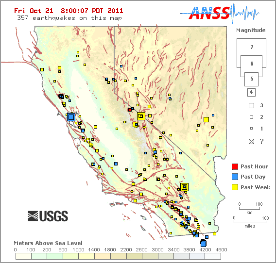
    MAP 4.3 2011/10/25 00:32:17 38.286 43.218 10.0 EASTERN TURKEY
    MAP 3.4 2011/10/25 00:06:45 32.178 -115.357 32.5 BAJA CALIFORNIA, MEXICO
    ______________________________________

    MAP 4.7 2011/10/24 23:55:16 38.462 43.620 7.6 EASTERN TURKEY
    MAP 4.6 2011/10/24 22:41:53 -25.032 -68.235 96.4 SALTA, ARGENTINA
    MAP 4.5 2011/10/24 22:13:32 38.615 43.163 10.0 EASTERN TURKEY
    MAP 4.8 2011/10/24 21:37:32 38.506 141.403 72.7 NEAR THE EAST COAST OF HONSHU, JAPAN
    MAP 2.6 2011/10/24 20:50:52 63.197 -150.920 137.4 CENTRAL ALASKA
    MAP 5.0 2011/10/24 17:34:59 -31.788 -179.130 99.3 KERMADEC ISLANDS REGION
    MAP 2.8 2011/10/24 17:07:21 18.643 -64.697 3.4 VIRGIN ISLANDS REGION
    MAP 4.3 2011/10/24 16:51:26 38.711 43.711 7.8 EASTERN TURKEY
    MAP 4.3 2011/10/24 16:40:26 38.723 43.644 15.5 EASTERN TURKEY
    MAP 4.5 2011/10/24 16:26:37 -5.304 146.881 187.8 EASTERN NEW GUINEA REG, PAPUA NEW GUINEA
    MAP 2.6 2011/10/24 15:58:44 40.046 -122.003 16.2 NORTHERN CALIFORNIA
    MAP 4.9 2011/10/24 15:28:07 38.617 43.166 14.2 EASTERN TURKEY
    MAP 2.8 2011/10/24 14:26:23 51.007 -179.508 46.9 ANDREANOF ISLANDS, ALEUTIAN IS., ALASKA
    MAP 4.3 2011/10/24 13:07:56 38.789 43.633 4.5 EASTERN TURKEY
    MAP 4.9 2011/10/24 11:49:59 -29.773 -176.280 36.2 KERMADEC ISLANDS REGION
    MAP 4.4 2011/10/24 10:30:20 38.580 43.566 17.4 EASTERN TURKEY
    MAP 3.1 2011/10/24 10:24:39 19.242 -67.035 45.4 PUERTO RICO REGION
    MAP 4.1 2011/10/24 10:17:01 16.333 -99.165 14.1 OFFSHORE GUERRERO, MEXICO
    MAP 2.5 2011/10/24 09:41:20 19.885 -155.542 17.0 ISLAND OF HAWAII, HAWAII
    MAP 4.8 2011/10/24 08:49:20 38.529 43.548 6.7 EASTERN TURKEY
    MAP 2.7 2011/10/24 08:46:19 60.122 -153.818 176.2 SOUTHERN ALASKA
    MAP 4.7 2011/10/24 08:28:27 38.625 43.514 6.3 EASTERN TURKEY
    MAP 4.5 2011/10/24 08:12:13 38.620 43.666 10.0 EASTERN TURKEY
    MAP 4.4 2011/10/24 06:44:57 38.743 43.345 5.4 EASTERN TURKEY
    MAP 2.8 2011/10/24 06:08:18 53.460 -165.307 25.9 FOX ISLANDS, ALEUTIAN ISLANDS, ALASKA
    MAP 4.6 2011/10/24 05:54:58 38.648 43.304 10.8 EASTERN TURKEY
    MAP 4.8 2011/10/24 04:43:04 38.504 43.240 24.3 EASTERN TURKEY
    MAP 4.3 2011/10/24 04:18:46 38.730 43.270 5.0 EASTERN TURKEY
    MAP 3.9 2011/10/24 02:23:14 38.737 43.161 2.3 EASTERN TURKEY
    MAP 3.4 2011/10/24 02:09:15 18.223 -68.205 90.0 MONA PASSAGE, DOMINICAN REPUBLIC
    MAP 4.0 2011/10/24 01:03:04 38.847 43.648 2.3 EASTERN TURKEY
    MAP 4.2 2011/10/24 00:50:49 38.448 43.520 11.2 EASTERN TURKEY


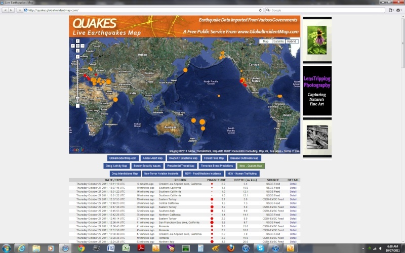
    2011-10-25 01:35:33.5
    08min ago
    40.46 N 24.32 E 10 2.1 AEGEAN SEA
    2011-10-25 01:26:21.6
    17min ago
    38.61 N 43.16 E 5 2.5 EASTERN TURKEY
    2011-10-25 01:24:50.2
    19min ago
    35.49 N 27.56 E 10 2.4 DODECANESE ISLANDS, GREECE
    2011-10-25 01:22:56.8
    20min ago
    38.73 N 43.39 E 5 3.1 EASTERN TURKEY
    2011-10-25 01:08:19.4
    35min ago
    39.06 N 29.08 E 6 2.5 WESTERN TURKEY
    2011-10-25 01:07:58.5
    35min ago
    38.71 N 43.38 E 5 3.2 EASTERN TURKEY
    2011-10-25 01:06:17.8
    37min ago
    38.78 N 43.35 E 5 2.6 EASTERN TURKEY
    2011-10-25 01:04:03.8
    39min ago
    36.83 N 30.21 E 5 2.9 WESTERN TURKEY
    2011-10-25 00:54:05.9
    49min ago
    38.88 N 43.49 E 5 2.7 EASTERN TURKEY
    2011-10-25 00:49:47.7
    54min ago
    38.73 N 43.32 E 5 2.8 EASTERN TURKEY
    2011-10-25 00:44:43.1
    59min ago
    40.44 N 21.16 E 10 2.4 GREECE
    2011-10-25 00:42:17.0
    1hr 01min ago
    38.70 N 43.67 E 5 3.4 EASTERN TURKEY
    2011-10-25 00:37:56.0
    1hr 05min ago
    38.71 N 43.33 E 20 3.3 EASTERN TURKEY
    2011-10-25 00:32:18.0
    1hr 11min ago
    38.65 N 43.07 E 7 4.3 EASTERN TURKEY
    2011-10-25 00:28:33.0
    1hr 15min ago
    38.81 N 43.22 E 5 3.6 EASTERN TURKEY
    2011-10-25 00:26:26.0
    1hr 17min ago
    39.01 N 43.61 E 2 3.6 EASTERN TURKEY
    2011-10-25 00:16:42.0
    1hr 27min ago
    38.61 N 43.12 E 7 3.6 EASTERN TURKEY
    2011-10-25 00:13:06.0
    1hr 30min ago
    38.73 N 43.29 E 5 3.8 EASTERN TURKEY
    2011-10-25 00:08:29.0
    1hr 35min ago
    38.63 N 43.14 E 23 4.0 EASTERN TURKEY


    ___________________


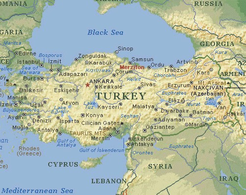
    Understanding the 7.2 magnitude earthquake in East Turkey (October 23, 2011)

    Tectonic explanation of what happened

    Turkey is a tectonically active country that experiences frequent destructive earthquakes. On a broad scale, the seismtectonics of the region near the October 23, 2011 earthquake are controlled by the collision of the Arabian Plate and Eurasian plates; at the latitude of this event, the Arabian plate converges with Eurasia in a northerly direction at a rate of approximately 24 mm/yr. West of the October 23, 2011, earthquake tectonics are dominated by strike-slip faulting on the East (in southern Turkey) and North (in northern Turkey) Anatolian fault zones. These large, translational fault systems extend across much of central and western Turkey and accommodate the western motion of the Anatolian block as it is being squeezed by the converging Arabian and Eurasian plates.

    http://earthquake-report.com/2011/10/24/understanding-the-7-2-magnitude-earthquake-in-east-turkey-october-23-2011/
    HigherLove
    HigherLove


    Posts : 2357
    Join date : 2011-01-27
    Age : 58

    The Earthquake/Seismic Activity Log - Page 19 Empty Re: The Earthquake/Seismic Activity Log

    Post  HigherLove Thu Oct 27, 2011 8:07 am

    Magnitude
    4.7
    Date-Time
    Thursday, October 27, 2011 at 06:37:09 UTC
    Wednesday, October 26, 2011 at 11:37:09 PM at epicenter
    Time of Earthquake in other Time Zones
    Location
    39.605°N, 120.470°W
    Depth
    13.7 km (8.5 miles)
    Region
    NORTHERN CALIFORNIA
    Distances
    15 km (9 miles) SSE (153°) from Whitehawk, CA
    17 km (11 miles) SSE (151°) from Valley Ranch, CA
    18 km (11 miles) SSE (151°) from Clio, CA
    56 km (35 miles) W (279°) from Reno, NV
    145 km (90 miles) NE (36°) from Sacramento, CA
    Location Uncertainty
    horizontal +/- 0.3 km (0.2 miles); depth +/- 0.6 km (0.4 miles)
    Parameters
    Nph= 20, Dmin=2 km, Rmss=0.08 sec, Gp= 79°,
    M-type=regional moment magnitude (Mw), Version=7
    Source
    California Integrated Seismic Net:
    USGS Caltech CGS UCB UCSD UNR
    Event ID
    nc71671056

    Magnitude 4.7 earthquake hits Northern California, USA
    http://earthquake-report.com/2011/10/27/magnitude-5-2-earthquake-hits-northern-california-usa/

    San Juan: shaking for about 10 seconds. dishes rattling. we are at 2,800 ft elevation and earthquakes are usually non-existent here


    Magnitude
    3.6
    Date-Time
    Thursday, October 27, 2011 at 12:36:44 UTC
    Thursday, October 27, 2011 at 05:36:44 AM at epicenter
    Location
    37.873°N, 122.251°W
    Depth
    9.7 km (6.0 miles)
    Region
    SAN FRANCISCO BAY AREA, CALIFORNIA
    Distances
    2 km (1 miles) E (87°) from Berkeley, CA
    4 km (3 miles) ESE (118°) from Albany, CA
    4 km (3 miles) SSE (147°) from Kensington, CA
    9 km (6 miles) NNW (347°) from Oakland, CA
    Location Uncertainty
    horizontal +/- 0.2 km (0.1 miles); depth +/- 0.4 km (0.2 miles)
    Parameters
    Nph= 83, Dmin=1 km, Rmss=0.17 sec, Gp= 29°,
    M-type=regional moment magnitude (Mw), Version=5
    Source
    California Integrated Seismic Net:
    USGS Caltech CGS UCB UCSD UNR
    Event ID
    nc71671256

    The Earthquake/Seismic Activity Log - Page 19 Indexf11


    MAP 3.6 2011/10/27 12:36:44 37.873 -122.251 9.7 SAN FRANCISCO BAY AREA, CALIFORNIA
    MAP 2.9 2011/10/27 12:21:17 33.208 -116.080 7.2 SOUTHERN CALIFORNIA
    MAP 2.5 2011/10/27 10:25:46 19.332 -155.171 6.2 ISLAND OF HAWAII, HAWAII
    MAP 2.9 2011/10/27 09:27:28 33.208 -116.079 7.1 SOUTHERN CALIFORNIA
    MAP 5.2 2011/10/27 08:04:24 37.249 43.846 17.5 TURKEY-IRAQ BORDER REGION
    MAP 3.2 2011/10/27 07:39:18 59.958 -152.708 97.7 SOUTHERN ALASKA
    MAP 2.5 2011/10/27 07:36:12 39.613 -120.475 14.1 NORTHERN CALIFORNIA
    MAP 4.7 2011/10/27 06:37:09 39.605 -120.470 13.7 NORTHERN CALIFORNIA
    MAP 4.3 2011/10/27 06:15:59 -17.873 -179.601 611.0 FIJI REGION
    MAP 4.6 2011/10/27 05:56:20 49.725 155.927 75.5 KURIL ISLANDS
    MAP 4.6 2011/10/27 05:04:05 -26.744 -178.104 75.8 SOUTH OF THE FIJI ISLANDS
    MAP 4.4 2011/10/27 03:29:34 -17.525 -178.755 515.5 FIJI REGION
    MAP 2.5 2011/10/27 02:37:32 32.909 -116.245 7.1 SOUTHERN CALIFORNIA
    MAP 3.0 2011/10/27 01:26:21 18.486 -66.137 104.8 PUERTO RICO REGION
    MAP 4.9 2011/10/27 01:20:34 -15.808 168.146 39.7 VANUATU
    MAP 6.0 2011/10/27 00:15:26 -17.914 -179.424 611.9 FIJI REGION
    MAP 3.0 2011/10/27 00:02:19 18.852 -67.338 10.7 PUERTO RICO REGION

    The Earthquake/Seismic Activity Log - Page 19 Untitl33

      Current date/time is Sun May 19, 2024 1:49 pm