http://www.telegraph.co.uk/travel/travelnews/8830654/Buenos-Aires-airport-halts-flights-due-to-volcanic-ash.html
Domestic airlines flights canceled in Argentina due to volcanic ash cloud

~ The only Home on the Web You'll ever need ~


Initial comment : Cerro Hudson volcano, a Southern Andean volcano located in the border area in between Chile and Argentina (click here to see the map) has started a minor eruption.
SERNAGEOMIN, the Chilean authority who is guarding the activity of the volcanoes has increased the alert level from 3 to 5 (Red Alert). Onemi, the Chile government organization who is coordinating all actions to protect people and infrastructure from being damages /injured has called the RED alert for the following localities : Aysén, Río Ibáñez and Chile Chico in the Aysén area.
Both organizations will of course follow up the situation of Cerro Hudson 24 hours on 24 and 7 days on 7. Due to the remote location of this volcano, the reporting from the eruptions will be far less than it was the case with the Puyehue – Cordón Caulle
Update October 28 – 14:24
In a report published at Buenos Aires at 13:30 yesterday (16:30 UTC), the regional VAAC (Volcanic Ash Advisory Committee) has confirmed a gas/steam column with low ash content above the Hudson volcano. The eruption cloud was observed between 1000 to 4000 m height. There was no sign outpouring of lava.
Update October 28 – 12:59 UTC :
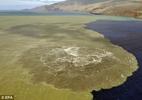
- Images taken during flights from emergency agencies, SERNAGEOMIN staff and local authorities revealed the presence of three (3) craters located on the southern edge – southeast of the caldera with approximate diameters of 300, 200 and 500 meters. 2 of the craters were emitting mostly white steam/gas columns, the third (largest) crater was emitting a combination of ash and steam/gases to a max. height of 5.5 km. Satellite images have measured the plume to be 12 km in length.
- The OMI website discovered a sulfur dioxide concentration around the volcano at 16:00 local time.
Update October 28 – 12:56 UTC :
- In consideration of the current characteristics of the eruption, an exclusion zone of 45 km radius around the crater has been set.
- SERNAGEOMIN has calculated with their theorectical models that an eruption column of 10 to 16 km will lead to considerable ashfall to the North East (Friday and Saturday).
http://earthquake-report.com/2011/10/27/chilean-authorities-are-raising-hudson-volcano-cerro-hudson-to-red-alert-after-minor-eruption/
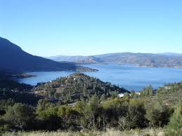


Mount Konocti
A Most Treasured Peak
According to Pomo Indian legend, a beautiful maiden who lived on Mount Konocti created Soda Bay at its foot with tears she shed over the deaths of her feuding father and lover. Today, Soda Bay still bubbles with volcanic gases at the foot of Mt. Konocti, which rises to 4,300 feet in elevation. The Clear Lake Volcanic Field consists of some seven once-active volcanic vents.
The name “Konocti” has mysterious origins. Though European settlers attempted to change Mt. Konocti’s name to “Uncle Sam Mountain” in 1854, the original name has endured. Several Indian tribes inhabited the area more than 11,000 years ago, and though they were all of the Pomo Nation, they spoke several languages native to their own tribes. Konocti means “big rock” in one Pomo language; another tribe credits Chief Konocti with creating the mountain. The most favored translation is “Mountain Woman,” from the Pomo word, “Knoktai,” of which “Kno” means “mountain” and “Hatai” means “woman” in one tribe’s language. An essential part of Pomo spirituality, Mt. Konocti is still sacred to Native Americans.
Mt. Konocti’s surface varies with elevation and exposure. The south slope of the mountain is covered with 12 square miles of black obsidian. At the bottom of the north face, a Douglas fir forest is dense and cool. The first homesteader’s cabin on the mountain, built by Mary Downen in 1903, still stands. Orchards and vineyards thrive in the volcanic soil in a multitude of microclimates, and a grove of ancient maul oaks near the summit date back more than 500 years.
At night, a beacon atop the dark mountain announces its presence, and in daylight, it is possible to view Mt. Konocti’s very own weather system create wispy clouds, high winds, or winter snow flurries. Changes in barometric pressure cause gusts of air to move into and out of the mountain’s vents. Though some locals believe huge catacombs exist within, only small caves have been found. The Pomos have handed down stories of throwing carved sticks into Mt. Konocti’s crater and later finding them floating in the lake.
Mt. Konocti is the stunning backdrop for nearly every scene around Clear Lake. Lake County recently purchased 1520 acres on the top of Mount Konocti, placing much of the mountain into public hands for perpetuity. Lands for many purposes - for reflection, for hiking, for enjoying nature. Mount Konocti County Park is scheduled to open in 2011. Visit Preserve Konocti or www.konoctitrails.com for more information.
http://www.lakecounty.com/AboutLC/Explore/Konocti.htm
-
El Hierro Volcano (Canary Islands) : Red alert – Strongest earthquake since October 8
Last update: October 30, 2011 at 9:47 am by By Armand Vervaeck and James Daniell
Based on all what follows Earthquake-Report.com predicts that PEVOLCA will meet very soon. Main reason : The increasing strength of the earthquakes.
- The strongest earthquake since October 8 (a M 4.4 quake at the time), now a Magnitude 3.9 quake, occurred at 07:46 this morning in the El Golfo bay. Its epicenter was close to the Frontera coast line. The 4.4 earthquake on October 8 was the start of a number of events like the beginning of harmonic tremor and the start of the green stain (eruption) soon after. The depth is still a secure 22 km. Some scientists are linking however the magma area below the El Golfo to the still continuing eruption to the south of La Restinga. These are however speculations who cannot be proofed.
- At earthquake-report.com we do not consider quakes up to Magnitude 5 as dangerous for houses, although indirect damage can be triggered by rockfall and landslides in mountainous areas like El Hierro. Authorities will certainly follow up the El Hierro landscape scars when the quakes get again to Magnitudes 4 to 5. This will be a major concern for the El Hierro authorities from now on.
http://earthquake-report.com/2011/09/25/el-hierro-canary-islands-spain-volcanic-risk-alert-increased-to-yellow/


 Homes evacuated on Canary Island as underwater volcano spews molten rock 60ft into the air
 ![]() burgundia Mon Nov 07, 2011 10:52 am
burgundia Mon Nov 07, 2011 10:52 am