tMoA

Would you like to react to this message? Create an account in a few clicks or log in to continue.
tMoA

~ The only Home on the Web You'll ever need ~

+30
Arrowwind
THEeXchanger
malletzky
LeeEllisMusic
CetaceousOne
MzKarma
greybeard
Brook
lawlessline
MargueriteBee
HigherLove
Jonah
solent
devakas
Micjer
Sanicle
hobbit
Mercuriel
immortalisdolor
giovonni
Floyd
Jenetta
enemyofNWO
lindabaker
JesterTerrestrial
gscraig
AscendingStarseed
mudra
burgundia
Carol
34 posters

    Earth Changes 2013 - Daily Updates

    Carol
    Carol
    Admin
    Admin


    Posts : 31699
    Join date : 2010-04-07
    Location : Hawaii

    Earth Changes 2013 - Daily Updates Empty Earth Changes 2013 - Daily Updates

    Post  Carol Wed Feb 16, 2011 9:25 pm

    Earth Changes 2013 - Daily Updates Landslide-davao-oriental-epa-20140113-003
    Floods hit South Philippines; 20 Dead, 13 missing, thousands displaced

    Earth Changes 2013 - Daily Updates Snow---UK-005
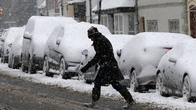
    Climate Chaos: Killer winter storms predicted to impact UK for next 30 years
    December 9, 2013 – LONDON - KILLER freezes, floods and heat-waves will devastate Britain during the next 30 years, climate ­experts have warned. Many people could die as extreme weather becomes common. There will be more freak winds like the October storm, which killed four people. Heat-waves will be lethal and the sea level will rise, leaving coastal towns at risk of being swamped by storm surges. Sir Brian Heap, president of the European Academies Science Advisory Council, said he felt “obliged” to issue the warning after a new study by the Intergovernmental Panel on Climate Change. It comes on the back of Typhoon Haiyan in the Philippines, which has killed more than 5,000 people. Sir Brian said: “Given the tragic events this year in the rest of the world and the recent IPCC report, EASAC feels obliged to draw attention to the growing impact of extreme weather in Europe.” The continent’s leading experts had made a detailed study of likely extreme weather, he said. Sir Brian warned: “From the major loss of lives in heat-waves to the economic and human costs of floods and storms, the implications are worrying. “They present the European Union and Member States with significant challenges in preparing Europe for a future with greater frequency of extreme weather.” –Daily Star

    Winter blast rewrites Oregon history: The record cold temperatures throughout Oregon continues to rewrite the history books, or at least add new chapters to them.  The city of Portland has not had a day with temperatures in the single digits since 1989 — a quarter-century ago. KOIN 6 News meteorologist Sally Showman said Portland stands a good chance of dropping into the single digits early Sunday morning. The high in the city on Saturday was only 30, the third day in a row with highs in the 30s. Sunday will also be cold, and the record low for December 8 is 8 degrees, set in 1972. The city of Portland opened up warming shelters for people to stay warm and keep warm. But the biggest problem is there is not enough space. JD Dilts is one of the people living on the streets since he lost his job. He’s thankful for the help of the Red Cross. “Man, it’s cold,” he said. “You take you gloves off your hands hurt.” That city-funded center helps hundreds of people stay warm, but it can only open when the temperature dips below 25. “It’s 26 degrees. When you start getting in the 30s, that’s cold,” Dilts said. Will Harris is the associate director of JOIN, a non-profit organization that helps people get back on their feet. He and others have been out helping people stay warm. “The main job is to keep them alive. We’ve been out the last six days helping people get the gear they need,” he said. “If they don’t, we will make sure they do.” Donations are necessary — blankets, coats, other winter items. Call 211 for more information on a drop center. –KOIN

    Summer snow in Australia: This is just the beginning. The really cold air and the really heavy snow is due later in the day, but snow is already falling today across the high country of New South Wales and Victoria. And yes, it’s December 5. The fifth day of summer. Your calendar is not wrong. Snow is not a freak event in southern Australia in the warmer months. A small dusting usually appears on the higher parts of the Australian Alps at least once each summer.  –News


    Earth Changes 2013 - Daily Updates APTOPIX%20Severe%20Weather%20IL_4213352_ver1.0_640_480
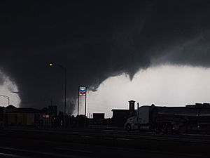
    Day of Death: 50 tornadoes tear through U.S. Midwest, leaving 5 dead
    Emergency workers arrived at a neighborhood in Illinois after tornadoes touched down to find scenes eerily reminiscent of  the destruction seen in the Philippines after Typhoon Haiyan made landfall.

    November 18, 2013 – ILLINOIS – A fast-moving storm system triggered multiple tornadoes on Sunday, killing at least five people, injuring about 40 and flattening large parts of the city of Washington, Illinois as it tore across the Midwest, officials said. The storm also forced the Chicago Bears to halt their game against the Baltimore Ravens and encourage fans at Soldier Field to seek shelter as menacing clouds rolled in. Chicago’s two major airports also briefly stopped traffic with the metropolitan area was under a tornado watch. The city of Washington, Illinois, was hit especially hard by what the National Weather Service called a ‘large and extremely dangerous  tornado. “It’s a sad day in Washington. The devastation is just unbelievable. You just can’t imagine. It looks like a war zone in our community,” said Washington Mayor Gary Manier. “It’s kind of widespread and went right through our community of 15,000 people,” he added, saying hundreds of homes in the town, 145 miles southwest of Chicago, had been destroyed. The state Emergency Management Agency said one person was killed in Washington. Thirty-one people injured by the storm were being treated at St. Francis Medical Center, one of the main hospitals in nearby Peoria, according to hospital spokeswoman Amy Paul. Eight had traumatic injuries.

    Two people were killed in Washington County, Illinois, about 200 miles south of Peoria, said Illinois Emergency Management Agency spokeswoman Patti Thompson. The agency estimated that hundreds of homes were damaged and at least 70 leveled across the state. Washington County coroner Mark Styninger said the two people who died there were elderly siblings. The 80-year-old man and his 78-year-old sister suffered massive trauma when their home was demolished in the storm, Styninger said. Two people were killed in Massac County, Illinois, on the Kentucky border where a twister devastated several neighborhoods, emergency officials said. “It wiped out homes, mobile homes,” said Charles Taylor, deputy director of the Emergency Services and Disaster Agency in Massac County. “It downed trees, power lines. We have gas leaks, numerous injuries whether they were in mobile homes, or outdoors, even in the motor vehicles, people have been trapped.” “We have reports of homes being flattened, roofs being torn off,” Sara Sparkman, a spokeswoman for the health department of Tazewell County, Illinois, where Washington is located, said in a telephone interview. “We have actual whole neighborhoods being demolished by the storm.” Sparkman said the storm also had caused damage in Pekin, south of Peoria.

    Illinois State Police spokeswoman Monique Bond said mobile homes were toppled, roofs torn from homes, and trees uprooted. She said officials believe some people may be trapped in their basements under debris. The American Red Cross worked with emergency management officials to set up shelters and provide assistance to displaced residents, even as rescue workers searched for more people who might have been caught and trapped in the storm’s path. The Washington tornado came out of a fast-moving storm system that originally headed toward Chicago as it threatened a large swath of the Midwest with dangerous winds, thunderstorms and hail, U.S. weather officials said. The National Weather Services’ Storm Prediction Center said the storm moved dangerously fast, tracking eastward at 60 miles per hour. This storm system had some similarities to the fast-moving “derecho” storm that knocked out power to more than 4.2 million people and killed 22 in the Midwest and Mid-Atlantic regions in June 2012, according to Bill Bunting, forecast branch chief at the Storm Prediction Center. According to news affiliate KIII TV3, the storm system may have unleashed as many as 50 twisters.  –Reuters KIII TV3


    Earth Changes 2013 - Daily Updates Typhoon-haiyan-survivors-in-philippines
    Philippine typhoon kills at least 10,000: survivors ‘walking around like zombies’
    November 10, 2013 – TACLOBAN, Philippines - One of the most powerful storms ever recorded killed at least 10,000 people in the central Philippines, a senior police official said on Sunday, with huge waves sweeping away entire coastal villages and devastating the region’s main city. Super typhoon Haiyan destroyed about 70 to 80 percent of the area in its path as it tore through Leyte province on Friday, said police chief superintendent Elmer Soria. As rescue workers struggled to reach ravaged villages along the coast, where the death toll is as yet unknown, survivors foraged for food as supplies dwindled or searched for lost loved ones. “People are walking like zombies looking for food,” said Jenny Chu, a medical student in Leyte. “It’s like a movie.” Most of the deaths appear to have been caused by surging sea water strewn with debris that many said resembled a tsunami, leveling houses and drowning hundreds of people in one of the worst natural disasters to hit the typhoon-prone Southeast Asian nation.

    The national government and disaster agency have not confirmed the latest estimate of deaths, a sharp increase from initial estimates on Saturday of at least 1,000 killed by a storm whose sustained winds reached 195 miles per hour (313 km per hour) with gusts of up to 235 mph (378 kph). “We had a meeting last night with the governor and the other officials. The governor said, based on their estimate, 10,000 died.” Soria said. “The devastation is so big.” More than 330,900 people were displaced and 4.3 million “affected” by the typhoon in 36 provinces, the UN’s humanitarian agency said, as relief agencies called for food, water and tarpaulins for the homeless. Witnesses and officials described chaotic scenes in Leyte’s capital, Tacloban, a coastal city of 220,000 about 580 km (360 miles) southeast of Manila, with hundreds of bodies piled on the sides of roads and pinned under wrecked houses. The city lies in a cove where the seawater narrows, making it susceptible to storm surges. The city and nearby villages as far as one kilometer (just over half a mile) from shore were flooded, leaving floating bodies and roads choked with debris from fallen trees, tangled power lines and flattened homes. TV footage showed children clinging to rooftops for their lives.

    ‘It was like the end of the world.’ –  Many internet users urged prayers and called for aid for survivors in the largely Roman Catholic nation on social media sites such as Twitter. “From a helicopter, you can see the extent of devastation. From the shore and moving a kilometer inland, there are no structures standing. It was like a tsunami,” said interior secretary Manuel Roxas, who had been in Tacloban since before the typhoon struck the city. “I don’t know how to describe what I saw. It’s horrific.” The UN’s Office for the Coordination of Humanitarian Affairs said aerial surveys showed “significant damage to coastal areas with heavy ships thrown to the shore, many houses destroyed and vast tracts of agricultural land decimated.” The destruction extended well beyond Tacloban. Officials had yet to make contact with Guiuan, a town of 40,000 that was first hit by the typhoon. Baco, a city of 35,000 people in Oriental Mindoro province, was 80 percent under water, the UN said. Six people were killed and dozens wounded during heavy winds and storms in central Vietnam as Haiyan approached the coast, state media reported, even though it had weakened substantially since hitting the Philippines. Vietnam authorities have moved 883,000 people in 11 central provinces to safe zones, according to the government’s website. Despite weakening, the storm is likely to cause heavy rains, flooding, strong winds and mudslides, as it makes its way north in the South China Sea.

    Earth Changes 2013 - Daily Updates Map_specnewsdct-01_ltst_4namus_enus_650x366
    Category 4 Tropical Cyclone Phailin makes landfall in India: 500,000 evacuated
    October 12, 2013 – INDIA – As many as 500,000 people in India have been evacuated as a massive cyclone sweeps through the Bay of Bengal towards the east coast. Cyclone Phailin, categorized as “very severe” by weather forecasters, is expected to hit Orissa and Andhra Pradesh states on Saturday evening. The Meteorological Department has predicted the storm will bring winds of up to 220km/h (136mph). A super-cyclone in 1999 killed more than 10,000 people in Orissa. But officials say this time they are better prepared, the BBC’s Sanjoy Majumder in Orissa reports. Officials said Cyclone Phailin was expected to make landfall close to the city of Gopalpur (Orissa state), bringing a storm surge of at least 3m (10ft) that was likely to cause “extensive damage” to mud houses on the coast. “No-one will be allowed to stay in mud and thatched houses in the coastal areas,” said Orissa’s Disaster Management Minister Surya Narayan Patra. The army is on standby in the two states for emergency and relief operations. Officials said helicopters and food packages were ready to be dropped in the storm-affected areas. Meanwhile, the US Navy’s Joint Typhoon Warning Centre predicted that Phailin could produce gusts of up to 296km/h (184 mph), while the London-based Tropical Storm Risk classified Phailin as a Category Five storm – the most powerful. Janmejay Mohapatra, a resident of Orissa state capital Bhubaneswar, said it was too dangerous to go out now, as trees were down and debris was flying everywhere. Cyclone Phailin is expected to be the biggest storm to hit the region for 14 years. “Already the rain is very heavy and the wind is gusting at 100-120km an hour,” he told the BBC. “The phone lines are down where I am and we have no electricity.” –BBC


    Earth Changes 2013 - Daily Updates 26978
    Scotland experiences four seasons in a day: lashed by 100 mph wind gusts
    September 16, 2013 – SCOTLAND - Scotland experienced all four seasons in one day yesterday, as the first storm of autumn swept across the country, bringing chaos to the country’s roads. Torrential rain, accompanied by gale-force winds, gave way to sunny periods, before the wet weather returned. The Cairngorms were hit by gusts of 100 mph, with snow anticipated last night, and the Forth Road Bridge was closed to high-sided vehicles after wind speeds of 69 mph were recorded. However, not everyone was bemoaning the gales. The weather was perfect for Scottish Windfest, at Barassie Beach in Troon, where windsurfers and kitesurfers were competing. Last night, the Met Office issued a blanket “yellow” warning, forecasting blustery winds continuing into today. They said high-altitude jetstream winds from the Atlantic pushing 200 mph – almost twice the usual – triggered the storm. It brought torrential rain yesterday morning, which flooded Nitshill Road and Thornliebank Road, in the south of Glasgow, with motorists in Dumfries suffering the worst driving conditions in the country with heavy spray on main roads.

    The weather also caused severe disruption to Caledonian MacBrayne’s ferry timetable on the west coast, where dozens of sailings were either delayed or cancelled. Worst affected were the routes between Oban, Coll and Tiree, the new link between Ardrossan and Campbeltown, and the Tarbert to Portavadie crossing. A spokesman for Cal Mac said: “Ferry services across the network have been badly affected by high winds. “The bad weather is expected to continue into Monday and ferry travellers are advised to check our website (www.calmac.co.uk) for the latest information. Traffic Scotland warned motorists of high winds on the Skye, Friarton, Tay and Erskine bridges. And there was rail disruption on west coast northbound routes, after a tree fell on to overhead lines between Lockerbie and Carstairs. The Scottish Environment Protection Agency (Sepa) issued flood warnings in Ayrshire and Arran, Dumfries and Galloway and west central Scotland. The CairnGorm funicular railway was closed all morning yesterday as 100mph winds blasted the area, but it was opened by midday. Paul Nixon, CairnGorm’s customer manager, said: “We’ve just been keeping a close eye on the weather today, making sure that visitors can come back down. “We’re expecting some snow tonight, but it’s unlikely to lie and will be restricted to the very top of the mountain. “This sort of weather usually does mark the start of winter for us really. In the past there has been skiing in October, and people are anticipating a very good season.” Tom Morgan, of the Met Office, said: “Scotland is only half-way there with the severe wind problems. –The Scotsman[/center]


    Last edited by Carol on Wed Jan 15, 2014 9:53 am; edited 255 times in total


    _________________
    What is life?
    It is the flash of a firefly in the night, the breath of a buffalo in the wintertime. It is the little shadow which runs across the grass and loses itself in the sunset.

    With deepest respect ~ Aloha & Mahalo, Carol
    Carol
    Carol
    Admin
    Admin


    Posts : 31699
    Join date : 2010-04-07
    Location : Hawaii

    Earth Changes 2013 - Daily Updates Empty Re: Earth Changes 2013 - Daily Updates

    Post  Carol Wed Feb 16, 2011 9:29 pm

    Earth Changes 2013 - Daily Updates 91c735ed4c17a71136db69898b33
    European cold weather kills hundreds, saps power systems, freezes Danube
    Europe continues to suffer through its coldest February in 26 years
    February 10, 2012 – ROMANIA – Europe’s record freezing temperatures have claimed hundreds of lives, snarled traffic and trapped tens of thousands of residents in remote villages across Serbia and Romania. It is the worst cold snap to happen in February in 26 years, Georg Mueller, a forecaster at Point Carbon told Reuters. “It was in 1986 when we had the last similarly severe cold weather (in February),” he said. “In this instance this big blocking of cold air . . . seemed to influence the way the winds behaved rather than the other way around,” he said. “We didn’t expect the cold block to become so persistent and then move westward.” In many European capitals, authorities have set up extra shelters for the homeless to help them survive the cold snap that has seen temperatures sink as low as minus 36 C. The majority of the cold-related deaths have been of the homeless. Meteorologists predict the frigid temperatures will last until the end of February. “We do have higher confidence in a change by mid-February, but not to milder weather,” Leon Brown, a meteorologist at The Weather Channel in Britain, told Reuters. “February will probably remain a cold month right to the end.” –The Star http://www.thestar.com/news/world/article/1128567--european-cold-weather-kills-hundreds-saps-power-systems?bn=1


    Warning system glitches found after Alaska quake
    JUNEAU, Alaska -- Glitches are being reported in Alaska's tsunami warning system after Thursday night's 7.3 earthquake in the Aleutian chain
    Read more: http://www.sacbee.com/2011/06/24/3725359/warning-system-glitches-found.html#ixzz1QDj9WZSC

    Snow Falling in Colorado on Eve of Northern Hemisphere’s Summer Solstice
    The calendar says summer starts tomorrow in the Northern Hemisphere. The snow falling in the mountains of Colorado tells a different story.
    A storm that has prompted a tornado watch across Nebraska and Kansas today also left 2 to 4 inches of snow in the Rocky Mountains, said Joe Ramey, a weather service meteorologist in Grand Junction, Colorado.

    “It is unusual,” Ramey said. “Here it is the last day of spring.”

    A winter storm advisory has been posted in the mountains of Colorado above 10,000 feet until 6 p.m. local time, and at least one tornado was reported in Kansas, according to the weather service. The Northern Hemisphere summer starts at 1:16 p.m. New York time tomorrow.

    Ramey said the lingering effects of the La Nina ocean cooling are still playing havoc with local weather patterns. Normally at this time of year the daytime high temperature in Grand Junction, at an altitude of almost 4,600 feet, is 88 degrees Fahrenheit (31 degrees Celsius), according to the weather service. Yesterday it was 59, Ramey said.
    La Ninas can bring more rain and stormy conditions to the northern U.S., while drying out the southern half of the country. The most recent La Nina was declared over earlier this month by the U.S. Climate Prediction Center in Camp Springs, Maryland.
    The atmosphere is still showing signs of the phenomenon, however.
    http://www.bloomberg.com/news/2011-06-20/snow-falling-in-colorado-on-eve-of-northern-hemisphere-s-summer-solstice.html

    Earth Changes 2013 - Daily Updates 24920096
    SALT LAKE CITY Flooding threat remains a few more weeks
    SALT LAKE CITY — The mountain snowpack is still the largest seen in 10 to 15 years with enough left in the mountains to pose a flooding threat for a few more weeks.

    "A week of mid-80s will cause flooding. Lower temperatures would drop that threat," says a Friday situation report from the Utah Division of Emergency Management. "Let's not forget that people need to be extremely cautious around rivers and creeks, which are cold and running fast."

    KSL meteorologists are forecasting temperatures in the mid- to upper 70s through Monday, with Tuesday being the first day the daytime high is expected to reach 80. But the longer-range forecast shows temperatures continuing to climb after that, reaching 86 by Thursday. That trend will steadily increase streamflows as mountain snow continues to melt.

    Track the water levels of creeks and rivers near you with our Live 5 River Flow Tracker.
    Shorter term, flood warnings for high river flows expired Friday for Lost Creek in Morgan County, the south fork of the Ogden River in Weber County, and the Weber River in Davis, Morgan, Summit and Weber counties. Flooding on the lower Weber County near the Great Salt Lake is not the result of high river flows as much as a levee that broke Thursday morning.

    In Juab, Piute, Sanpete and Sevier counties, a flood warning for the Sevier River from Piute Reservoir to Yuba Lake expired Friday afternoon.

    Moderate flooding is being reported on the Green River near Jensen in Uintah County and near Green River in Grand County. Minor flooding has been in the forecast for the Colorado River in Grand County near the Utah-Colorado state line, but that warning was expected to expire Friday afternoon.

    The Utah Department of Transportation reports flooding on roadways may slow or close segments of state Route 128 in Grand County, state Route 100 in Millard County, state Route 16 in Rich County in the area of Wolf Creek, and state Route 118 in Sevier County, where the road Friday was closed at milepost 1.5 in Joseph due to flooding from the Sevier River.

    UDOT reports it is still delaying the opening of several seasonal roads because of remaining mountain snowpack. Those include state Route 39 in Monte Cristo east of Ogden; state Route 65 in East Canyon northeast of Salt Lake City; state Route 190 in Guardsman Pass between Brighton and Park City; state Route 224 in Guardsman Pass between Park City and Midway; state Route 92, the American Fork Canyon/Alpine Loop; state Route 150, the Mirror Lake Highway between Kamas and the Wyoming border; state Route 35, the Wolf Creek Pass between Francis and Hanna; state Route 153, the Mount Holly Junction east of Beaver; and state Route 148, Cedar Breaks east of Cedar City. http://www.ksl.com/?nid=960&sid=15919225&s_cid=rss-960


    https://www.youtube.com/watch?v=w0Zueh_ljZU&feature=player_embedded
    Paar Foto's von den Spreetshoogte Schneefall.

    Earth Changes 2013 - Daily Updates Iceland1
    Far from over? Iceland shaken by multiple swarms of earthquakes
    June 7, 2011 - ICELAND – It seems nothing with the Earth is what it seems these days and everything is on a dynamic hair-trigger that could change in an instant. After the eruption of the Grímsfjall volcano abated, it seems Iceland is now shaking again.

    Earth Changes 2013 - Daily Updates 300x200_06061440_heat-waves
    Searing heatwave roast states across much of the U.S.
    June 8, 2011 – MINNESOTA – The temperature soared to 103 on Tuesday, setting a record for the date and bringing thermometers up to levels not seen in nearly 23 years. It caused roads to buckle, people to seek medical attention and several outdoor events to be canceled or moved indoors. The last time the Twin Cities saw the temperature this hot was July 31, 1988, which saw a high of 105, according to the National Weather Service office in Chanhassen. Temperatures last hit triple digits on July 31, 2006, with a high of 101. The 103-degree reading – which smashed the previous June 7 record of 95 degrees, set in 2004 – was measured at Minneapolis-St. Paul International Airport at 3:26 p.m., the weather service said. Ramsey and Hennepin counties were under an excessive heat warning through 7 a.m. Wednesday, and the weather service advised people to drink extra water, stay in air conditioning and out of the sun, and check on relatives and neighbors who might be sensitive to the heat. Local hospitals reported several cases of heat-related illnesses Tuesday, though a strong wind might have helped cool some who were suffering, said Dr. Greg Loppnow, the assistant medical director of the emergency room at the University of Minnesota, Fairview. “Most people tend to lay low when it’s this hot out, and that’s exactly what they should do.” –Twin Cities


    Earth Changes 2013 - Daily Updates Volcan13
    Volcanic chaos spreads- skies over Argentina turn to night
    June 4, 2011 – SANTIAGO (Reuters) – A volcano dormant for decades erupted in south-central Chile Saturday, belching ash over 6 miles into the sky and prompting the government to evacuate several thousand residents, authorities said. Winds fanned the ash toward neighboring Argentina, darkening the sky in the ski resort city of San Carlos de Bariloche, a government official there said, adding the city’s airport had been closed. The eruption in the Puyehue-Cordon Caulle volcanic chain, about 575 miles south of the capital, Santiago, also prompted Chilean authorities to shut a heavily traveled border crossing into Argentina. It was not immediately clear which of the chain’s four volcanoes had erupted because of ash cover and weather conditions. The chain last saw a major eruption in 1960. Local media said the smell of sulfur hung in the air and there was constant seismic activity. “The Cordon Caulle (volcanic range) has entered an eruptive process, with an explosion resulting in a 10-kilometre-high gas column,” state emergency office ONEMI said. The government said it was evacuating 3,500 people from the surrounding area as a precaution. It was the latest in a series of volcanic eruptions in Chile in recent years. Chile’s Chaiten volcano erupted spectacularly in 2008 for the first time in thousands of years, spewing molten rock and a vast cloud of ash that reached the stratosphere. The ash also swelled a nearby river and ravaged a nearby town of the same name. The ash cloud from Chaiten coated towns in Argentina and was visible from space. -Reuters


    oooh, not the best news. June 5th - INCOMING EARTH FACING SOLAR ERUPTION FORMING NOW
    Earth Changes 2013 - Daily Updates 20110605_085424_d7c2A

    Earth Changes 2013 - Daily Updates 20110604_2249_c2_512

    Earth Changes 2013 - Daily Updates 20110604_2318_c2_512
    It's still forming, but roughly 8 seconds for a flare, and 2 to 3 days for a CME.

    Earth Changes 2013 - Daily Updates 110603-mexico-volcano-815a.grid-8x2
    Volcano blasts tower of ash near Mexico City
    http://www.sacbee.com/2011/06/03/3674368/mexicos-popocatepetl-volcano-blasts.html
    http://www.msnbc.msn.com/id/43268083/ns/world_news-americas/

    Earth Changes 2013 - Daily Updates Images?q=tbn:ANd9GcT-bPNGdk_4AUPPmur_aNyK-ek1B90-HVtF2qC9_NO7YTFH3QBG
    Snow melting, dams filling, floods feared in West
    June 3, 2011 – DUBLIN GRAND COULEE DAM, Wash. — The giant concrete dams of the Pacific Northwest are overflowing with water. Wyoming has deployed National Guard troops to pile up sandbags. A federal official compares the impending situation to a bucking bull ready to storm out of his chute. States across the West are bracing for major flooding in the coming weeks once a record mountain snowpack starts melting and sending water gushing into rivers, streams and low-lying communities. The catalyst will be warmer temperatures forecast for the next week that could set off a rapid thaw. Randy Julander, a supervisor with the U.S. Department of Agriculture’s Natural Resources Conservation Service, says flooding this year could be worse than anyone has ever seen. Julander said in a typical year the weather warms gradually, allowing snow in the mountains to melt slowly and ease into rivers and streams over time. That’s not the case this year after a cool, rainy spring. “It’s all just sitting there, sitting there, sitting there. Everyone knows it’s going to come down, it’s just when and how quick that we’re all waiting for,” he said. “The bull is basically sitting in the chute and the gates are already open. He’s just not coming out to play yet, but when he does I anticipate he’s really going to be ticked off and bucking hard.” At Grand Coulee Dam, gigantic cascades of water are being released to make room for spring snowmelt that is expected to fill the reservoir. A constant roar emanates from the structure as surging water churns the Columbia River below the dam into a white froth. The dam is 500 feet tall, a mile across, and one of the largest concrete structures on Earth. It is the centerpiece of a network of dams built across the Pacific Northwest during the New Deal era that essentially act as a giant plumbing system for the region – and these days the pipes are overflowing. The dam is releasing so much water that millions of fish have been put in jeopardy. The heavy flows through dam spillways capture dangerous levels of nitrogen from the air, and the gas bubbles give fish the equivalent of the bends. A fish farm near the Grand Coulee Dam says an estimated 100,000 fish are dying every day, and has gone to court to slow down the flows. -The Seattle Times


    May 31, 2011 – CUBA - This Saturday, the local residents Holguin de Las Lajas, in the municipality of Calixto Garcia, lived a remarkable day when around 05:00 pm, in the midst of a heavy rain, began a strong and prolonged hailstorm never seen in these parts. This was confirmed by correspondent Rene Cabrera Mulet, who captured the unusual image of the hailstones, some the size of a Cuban currency 20 cents, covered tens of meters across the town. It is a phenomenon never before seen there, or by most of the inhabitants who have lived there all their lives. The storm of hail was accompanied by strong gusts of wind that toppled trees and severely affected homes, crops and cattle, in a totally agricultural. This large-scale local storm also affected other parts of the North calixteño as the villages of Head, Virginia and St. Augustine of turpentine. Immediately, local authorities were called in to the affected regions to assess the damages. -Patria Grande

    Tropics: Eye on the Caribbean This Week
    "Regardless of whether the low strengthens..., flooding downpours will remain a threat along its path." The 2011 Atlantic Hurricane Season officially starts on Wednesday and it is possible that the tropics will turn active immediately in the Caribbean. The latest computer models continue to indicate the formation of an area of low pressure in the southwestern or central Caribbean within the next few days. The warmer-than-normal waters of the Caribbean could eventually allow this low to develop into a more organized tropical system. The potential for a tropical depression or an even stronger system to take shape will also increase during the upcoming days as wind shear (strong winds high in the atmosphere) weakens. Related to the Story Was Super-Typhoon Songda Unsual? 2011 Atlantic Hurricane Season will be Active, Have More U.S. Landfalls Hurricane Damage: High Winds, Tornadoes, Storm Surge Keep Your Pets Safe During a Hurricane: Have a Plan Safety at Sea or in Port Homeowners Policies Canceled Wind shear is currently too powerful and disruptive for the formation of any tropical system. It is premature to say exactly where the tropical system will head if indeed development occurs. The system may get steered northeastward in the direction of Jamaica, Hispaniola or eastern Cuba. Another scenario is that the system drifts into the northwestern Caribbean. With uncertainty, all residents and visitors across the Caribbean should check back with AccuWeather.com and monitor the progress of the low. Regardless of whether the low strengthens into a tropical depression or named storm, flooding downpours will remain a threat along its path. If the low eventually becomes a tropical storm, it would acquire the name "Arlene." http://www.accuweather.com/m/News/Story/50281/eye_on_the_caribbean_for_tropi.aspx

    Earth Changes 2013 - Daily Updates Capt.0c678d9f29174ecb821489cee25845d9-0c678d9f29174ecb821489cee25845d9-0
    MORE TWISTERS TO COME
    http://www.weather.com/outlook/weather-news/news/articles/tornado-outbreak-tue-classic-ingredients_2011-05-23

    http://www.dutchsinse.com/blog/?p=862
    Scalar Square out of Springfield / Rolla, MO — new forecast for next 24-48 hrs
    Posted on May 23, 2011 by dutchsinse
    here is the video forecast cover the next 2-3 days.

    HAARP ring outbreak, along with several Scalar Square returns = new forecast for the next 24-48 hours from 11pm CST 5/22/2011 Areas named include:

    Shreveport Louisiana
    Southern Missouri (springfield, rolla, lebanon — north to Bowling Green MO)
    Kansas City, MO
    Georgetown, San Antonio, and Dallas Texas
    Little Rock Arkansas
    Fayetteville Arkansas
    Grand Rapids Michigan
    Nashville Tennessee , Knoxville, chatanooga Tennessee
    Hazelgreen , Huntsville Alabama
    Oswego, Watertown, Boonville New York

    HAARP ring outbreak sites from 2 days ago = SEVERE today at ALL named sites


    http://www.dutchsinse.com/blog/?author=1

    Earth Changes 2013 - Daily Updates Rockies%20late%20snow-856285734_v2.grid-8x2
    Late snow storms dump on West, create new flood front
    'Waiting for the chute to open and the bull to come out bucking, but he ain't moving, yet'

    http://www.msnbc.msn.com/id/43083815/ns/weather/
    SALT LAKE CITY — Late winter storms are packing a punch to the Rockies, piling snowpack on top of already record levels across the West where officials are concerned about historic flooding, avalanches and mudslides.
    "At this point, everybody is just sitting back chewing fingernails and waiting because the longer it stays cold and wet, the worse it's going to get," said Randy Julander, a supervisor with the U.S. Department of Agriculture's Natural Resources Conservation Service.
    Julander said in a typical year the weather warms gradually, allowing snow in the mountains to melt slowly and ease into rivers and streams over time. That's not the case this year.
    "June is right around the corner and sooner or later, it's going to warm up," he said, noting that instead of gradually warming over eight to ten weeks, the West will likely see a rapid rise in temperatures heading into summer, a worst case scenario.
    "And it's not just Utah, Colorado and Wyoming. It's basically all of the western states except Arizona and New Mexico," Julander said.

    Earth Changes 2013 - Daily Updates NHWV-e1305107651121
    Vortex superstorm system breakout across the globe?
    May 13, 2011 – An upper level low is a region of positive vorticity. This positive vorticity can be caused by counterclockwise curvature around the upper level trough and counterclockwise shear associated with the speed shear of a jet streak. The circulation around an upper level low can build to the surface over time. In these cases, two areas of low pressure will be noticed on the surface chart. These are sometimes referred to as double-barrel low-pressure systems. Upper level lows can also decrease in intensity through time. There are three, possible four total systems forming on North American Continent. One Vortex Over Alaska, One Vortex in Mid West states and the Vortex on the East Coast. -Crisis Boom http://crisisboom.com/2011/05/11/multiple-vortex-forming-over-northern-america/


    Earth Changes 2013 - Daily Updates Story
    Hawaii experiences another ominous night with record number of lightning strikes
    May 4, 2011 – HAWAII – A wicked storm that brought hail, waterspouts and torrential rain to the islands Monday night, also packed an electrical punch that rocked Oahu and Kauai. “Yeah lightning can strike twice, it can strike 10-15 times in the same location,” said Warning Coordinator Meteorologist Michael Cantin. For the second time this year, Hawaii has experienced a spectacular electric show. In late February we saw nearly 21,000 lightning strikes in a five-hour window when a storm system stalled over Hawaii. “In total about 15,000 between that time period if you include that hour before from 4 p.m. it’s almost 20,000,” said Cantin. And if you look at a 30-hour window, Hawaii experienced a whopping 45,000 lightning strikes. Once again, residents were out with cameras and smart phones. “As exciting as they may be to see and as neat as phenomena as they are they are exceptionally dangerous. Waterspouts can over-turn boats, they can swallow up swimmers, they can cause the water to drown you, the strong winds,” he said. “Lightning obviously can electrocute you and burn you severely and leave you either dead or with major trauma.” A Waianae family reported lightning struck an antenna pole on their home shocking someone lying on the floor. Emergency officials say he was briefly unconscious but was not seriously injured. “When it comes to lightning especially of this magnitude no injuries, no deaths, and really not much damage whatsoever is extremely lucky.” –Khon2


    Earth Changes 2013 - Daily Updates Pb-110429-portugal-hail-1.photoblog900
    Freak hail storm covers Lisbon streets with layers of snowy ice
    April 30, 2011 – LISBON, Portugal- By all accounts, it was a very unusual storm. Temperature dropped in less than 10 minutes from 27ºC to15ºC, and what we’ve got in Lisbon area, was a suddenly sea of hail, that in some less sunny places, still remains up to this morning. Some reports showed temperature lows of 5ºC. The situation was so dire, heavy equipment was called in to clear the streets.
    Earth Changes 2013 - Daily Updates Pb-110429-portugal-hail-2.photoblog900
    Bulldozers try to remove the hail from the streets in Damaia near Lisbon, Portugal,
    after a violent rainstorm hit the Lisbon region in the afternoon of April 29, 2011, covering
    the streets with a thick layer of icy hail. -MSNBC

    Earth Changes 2013 - Daily Updates 300x225_04272342_tuscaloosatornado2
    https://www.youtube.com/watch?feature=player_embedded&v=vLv7PZVipNU
    This amateur video captures the mile-wide tornado that sweep through Tuscaloosa, Alabama.
    It is said to be an EF5 event and considered to be the worst tornado in Alabama’s history.
    Even at a distance, the sheer size of the massive tornado is producing an almost deafening sound of destruction.


    Tornado doomsday: 150 twisters drop from the skies- 178 dead
    April 27, 2011–TUSCALOOSA, Ala.(AP) — The death toll from severe storms that punished five Southern U.S. states jumped to a staggering 178 after Alabama canvassed its hard-hit counties for a new tally of lives lost. Alabama’s state emergency management agency said early Thursday it had confirmed 128 deaths, up from at least 61 earlier. “We expect that toll, unfortunately, to rise,” Gov. Robert Bentley told ABC’s “Good Morning America.” Mississippi officials reported 32 dead in that state and Tennessee raised its report to six from one. Another 11 have been killed in Georgia and one in Virginia. The fierce storms Wednesday spawned tornadoes and winds that wiped out homes and businesses, forced a nuclear power plant to use backup generators and even prompted the evacuation of a National Weather Service office. The National Weather Service’s Storm Prediction Center in Norman, Okla., said it received 137 tornado reports around the regions, including 66 in Alabama and 38 in Mississippi. One of the hardest-hit areas Wednesday was Tuscaloosa, a city of more than 83,000 and home to the University of Alabama. The city’s police and other emergency services were devastated, the mayor said, and at least 15 people were killed and about 100 were in a single hospital. A massive tornado, caught on video by a news camera on a tower, barreled through the city late Wednesday afternoon, leveling it. By nightfall, the city was dark. Roads were impassable. Signs were blown down in front of restaurants, businesses were unrecognizable and sirens wailed off and on. Elsewhere, 11 people were killed in Mississippi, another 11 people were reported dead in Georgia and one person died each in Tennessee and Virginia. The storm system spread destruction from Texas to New York, where dozens of roads were flooded or washed out. –Associated Press

    April 27, 2011 – MEMPHIS – The outbreak of the latest round of severe storms pounding the south has claimed another life. The Monday night storms the extended into a violent Tuesday hit the town of Vilonia, Arkansas the hardest. The initial death toll of 5 had doubled during the damage assessment yesterday in a combination of tornadoes and flood water. Northwestern parts of the state had over 15 inches of rain since Easter weekend. Overnight, another storm rolled through eastern Arkansas and killed a person in their Sharp County home. The state capital Little Rock was also hit, as a local grocery store had its roof ripped off. The latest death total is up to 11, with more still missing. On Tuesday, another 40 tornadoes were reported by the Storm Prediction Center. The National Weather Service now says 45 tornadoes were reported. The hardest hit region was once again from East Texas through Arkansas. Another potential tornado led to damage in central Michigan. –Examiner

    Update: A rare mix of factors combined to cause widespread severe weather and dozens of reported tornadoes across the southern United States Wednesday, experts said. The National Weather Service had already received more than 150 reports of tornadoes by Wednesday night, and that number appeared to be climbing rapidly. “This could be one of the most devastating tornado outbreaks in the nation’s history by the time it’s over,” CNN Meteorologist Sean Morris said. -CNN
    New eruptions reported at Etna volcano in Italy
    Earth Changes 2013 - Daily Updates 20110409_2001GMT
    http://bigthink.com/ideas/37814
    April 11, 2011 – SICILY – Etna has sprung back to life as April opens, with new eruptions from the Southeast Crater Cone. Friday and Saturday (April 8-9), the Italian volcano produced some ash and a 3-km lava flow, but then quieted. However, the seismicity under the volcano continued and late tonight into today (April 10), Etna starting producing small strombolian explosions from the Southeast Crater Cone.

    Heavy rainfall leads to landslide in Turkey- 2 dead
    pril 10, 2011 – ISTANBUL - A landslide caused by heavy rains killed two children trapped under the wreckage of their collapsed home, while the other four family members suffered injuries, in Erzurum on Sunday morning, Turkish Cihan news agency said. Due to heavy rainfall in the eastern province, a landslide knocked over one wall of the family’s mud-brick house, causing it to collapse. Two children died. The remaining four family members were rescued by provincial civil protection and search-and-rescue teams and taken to the local hospital for treatment. –World Bulletin
    Posted in Earth Changes, Earth Watch,

    April 7th, 2011 = planetary alignments and solar flares
    https://www.youtube.com/embed/HLGelPZ3bNo?rel=0
    Alignments Jupiter - Sun and two other alignments.
    Mars - Sun - Mercury, and Neptune - Venus - Earth
    7.4 NEAR EAST COAST OF HONSHU, JAPAN

    4.3 BAJA CALIFORNIA, MEXICO
    6.5 CHIAPAS, MEXICO
    4.7 NEAR EAST COAST OF HONSHU, JAPAN
    4.6 NEAR EAST COAST OF HONSHU, JAPAN
    5.1 OFF E. COAST OF S. ISLAND, N.Z.

    http://137.229.36.30/cgi-bin/magnetometer/plotstations.cgi?latest+36H+500+KAK+FYU+EGL+DSC+COL+GAK+ANC+HOM+HDZ
    [size=18]7.1 strikes off Coast of Indonesia, tsunami warning issued


    Earth Changes 2013 - Daily Updates Article-0-0B45FAD200000578-321_634x499
    Giant algae bloom appears in the English Channel
    March 27, 2011 - LONDON – An enormous algae bloom 50 miles long has been discovered in the English Channel. The swarm of Skeletonema has come to the surface between the Lizard in Cornwall and Salcombe in Devon because of the warm weather. Scientists at the Plymouth Marine Laboratory (PML) discovered the bloom and another off the south east coast of Ireland using satellite images. They say that it poses no threat to humans and has appeared earlier in the year than usual thanks to the mild temperatures of the last few weeks. It would be visible from boats as a green/brown layer on the surface of the water. Dr Peter Miller, PML’s Earth observation scientist, said: ‘Skeletonema is a beautiful microscopic plant that given the right conditions reproduces rapidly to cover large areas of coastal seas. ‘Over the winter nutrients have built up in the sea and the windy weather we have experienced recently has stirred them up to the surface. Combined with the now calmer conditions and bright sunny days everything slotted into place to enable this plant to reproduce and form a large bloom.’ -Daily Mail

    Earth Changes 2013 - Daily Updates Greece-3-27
    Greece hammered by seismic tremors- 12 in 14 hours
    March 27, 2011 – ATHENS - The quakes almost form an elaborate circle around the southern parameter of Greece, where fault indentions in the sea are notable. It is well known that the Aegean and surrounding area, which includes mainland Greece, the Aegean Sea, Albania, S. Yugoslavia, S. Bulgaria, W. Turkey and part of the Northern Eastern Mediterranean, is seismically the most active region in the whole Mediterranean and in the whole of West Eurasia. This region is a part of the collision zone between the Eurasian and the African lithospheric plates but its present tectonic activity is much higher than in other regions of the same zone. The Mediterranean ridge is a submarine crustal swell that extends from the Ionian Sea to Cyprus and parallels the Hellenic trench. The Hellenic trench consists of a series of depressions with depth to about 5km. It parallels the Hellenic arc and includes some linear trenches, as are the Pliny and Strabo southeast of Crete and the Ionian trench. The Santorini volcano is quiet but still alive and well and may be biding its time. -The Extinction Protocol

    Earth Changes 2013 - Daily Updates Ethan-Tweedie1_strip
    Night (Moonbow) Rainbow Kamuela, Hawaii
    "It was a moonbow," explains Tweedie. The bright moon played the role of sun, illuminating nightime raindrops falling through the damp Hawaiian air. "I've been trying to photograph a moonbow for a long time. Last night I was driving back from the Volcano there it was!" - www.spaceweather.com

    Earth Changes 2013 - Daily Updates Article-0-0B32512300000578-686_634x726
    Heavenly haze: Remarkable rainbow cloud towers over Mount Everest
    http://www.dailymail.co.uk/sciencetech/article-1366794/Rainbow-cloud-towers-Mount-Everest.html

    Usually high temperatures in U.S. now threaten 100 year old records after record cold that saw colder temps in Oklahoma than in Antarctica.
    http://twitter.com/Extinctionp/statuses/38040456180936704

    Earth Changes 2013 - Daily Updates GermanEarthquake
    Is Germany’s West Eifel volcanic field awakening?
    Swarm of earthquakes in the area
    Last erupted in sync with the ice-age cycle
    15 Feb 11 – KOBLENZ, Germany - Beneath the calm waters of Germany’s famous Laacher See lake lies a potential killer that could devastate a good portion of Europe, says this article on The Extinction Protocol.

    "Today the region near Koblenz was shaken by a swarm of 7 earthquakes beginning with a 4.5 magnitude quake which erupted at a depth of 6 km."

    We think this is an indication, the article warns, that Germany's super-volcano is awakening.

    "Across the planet, the giant dormant volcanoes, one by one, are being stirred from their long and ancient slumber. Earth is on the precipice of major geological change."

    "The last time the Laacher See super-volcano erupted 12,000 years ago, it deposited ash across much of Europe. On July 30, 2010, a 5.6 earthquake struck the region and that likely signaled an awakening of the giant sleeping caldera."

    "Scientists believe that a new eruption could happen at any time."

    * 4.5 quake 6 km – Germany
    * 3.2 quake 11 km – Germany
    * 2.4 quake 12 km – Germany
    * 3.7 quake 20 km – Germany
    * 2.1 quake 20 km – Germany
    * 3.4 quake 12 km – Germany
    * 2.0 quake 10 km – Germany

    http://theextinctionprotocol.wordpress.com/2011/02/15/is-germanys-super-volcano-awakening-we-think-so/


    Last edited by Carol on Sat Apr 28, 2012 11:58 am; edited 1 time in total


    _________________
    What is life?
    It is the flash of a firefly in the night, the breath of a buffalo in the wintertime. It is the little shadow which runs across the grass and loses itself in the sunset.

    With deepest respect ~ Aloha & Mahalo, Carol
    Carol
    Carol
    Admin
    Admin


    Posts : 31699
    Join date : 2010-04-07
    Location : Hawaii

    Earth Changes 2013 - Daily Updates Empty Re: Earth Changes 2013 - Daily Updates

    Post  Carol Thu Feb 17, 2011 11:18 am

    Yellowstone is getting ready to erupt

    http://theinterveners.org/Yellowstone/wrapper.php?file=YMP_EHZ_WY_01.2011021700.gif

    Commentary from seismologists:
    There's a distinct Multiphase Harmonic tremor which means the caldera is showing tension and will release eruptions inorder to relieve the stress. These seismo anomolies don't resemble anything like quake readings. They have been going on for some time too. Awhile back there were readings that looked like they could be harmonic tremors as they resembled known harmonic tremor readings. Harmonic tremors are a good sign there will be (eruption) activity in the near days at yellowstone. (likely mid March)

    And it's present throughout most of the siesmos in the area, seems to be focused towards the southeast of the old caldera.

    Watch to see if the signal gets stronger and develops shortwave harmonics.

    Steam eruption VEI 1-3

    Localized eruption AOE ~20 km rad

    Timeframe is always difficult to pin with regular Volcanoes with Super-Volcanoes more so, but if it is to occur likely in 2-3 weeks (mid March)
    hppt://i1197.photobucket.com/albums/aa425/cozd7/pic4.jpg

    EQ-20110217-189571-US Common Alerting Protocol
    Magnitude: 3.8

    Mercalli scale: 2
    Date-Time [UTC]: 17 February, 2011 at 10:22:20 UTC
    Local Date/Time: Thursday, February 17, 2011 at 10:22 in the moorning at epicenter
    Location: 44° 27.150, 110° 24.786
    Depth: 0.90 km (0.56 miles)
    Region: North America
    Country: United States
    Distances: 11.85 km (7.36 miles) S of Lake, Wyoming
    Source: USGS-RSOE

    Earthquake
    Country: United States
    State: Wyoming
    Location: Lake
    Date: 2011-02-17 : 10:22:20
    Magnitude: 3.8
    Depth: 0.90 km

    Thursday February 17 2011, 10:55:04 UTC 7 minutes ago Mount St. Helens area, Washington 2.4

    Mount St. Helens is also getting active. A 5.1 set off Mt. St. Helene's. Before Pinatubo there were several smaller quakes like the one's we are seeing at Yellowstone. The Yellowstone caldera is only 5 miles deep, a quake at .9 could easily mean there is magma moving to the surface.


    http://hisz.rsoe.hu/alertmap/read/index.php?pageid=seism_read&rid=189571

    https://2img.net/h/i1197.photobucket.com/albums/aa425/cozd7/pic1.jpg

    http://theinterveners.org/Yellowstone/daythumbs.php
    http://quake.utah.edu/helicorder/mcid_webi.htm
    http://theinterveners.org/Yellowstone/daythumbs.php
    http://www.wunderground.com/US/WY/Yellowstone_National_Park.html
    http://www.solcomhouse.com/yellowstone.htm
    http://aslwww.cr.usgs.gov/Seismic_Data/heli2.shtml
    https://www.youtube.com/watch?v=rjI-nelg4Vc&feature=player_embedded#at=43
    https://www.youtube.com/watch?v=1Vn6kxfD3Ek&feature=player_embedded

    http://scienceray.com/earth-sciences/super-volcano-at-yellowstone-rising-at-record-rate-since-2004/

    GLOBAL EARTHQUAKE MAP http://quakes.globalincidentmap.com/

    Soda Valley, ARKANSAS Magnitude 3.8, 4.0 & 4.7
    https://2img.net/h/i1197.photobucket.com/albums/aa425/cozd7/pic5.jpg
    https://2img.net/h/i800.photobucket.com/albums/yy287/pondcypress/Mag40arkansas.jpg
    https://2img.net/h/i800.photobucket.com/albums/yy287/pondcypress/M47.jpg
    http://earthquake.usgs.gov/earthquakes/recenteqsww/Quakes/nm021711b.html

    We are only seeing the beginning of this today, we did not receive the full affects of the Solar flare, see below.

    Whether solar flares can trigger earthquakes: http://adsabs.harvard.edu/abs/2007AGUSMIN33A..03J

    Event Issue Date: 2011-02-15 05:47:44.0 GMT
    CME Arrival Time: 2011-02-17 02:57:50.0 GMT
    Arival Time Confidence Level: ± 6 hours
    Disturbance Duration: 6 hours
    Disturbance Duration Confidence Level: ± 8 hours
    Magnetopause Standoff Distance: 5.5 Re
    Thu, 17 Feb 2011 02:57:50 GMT
    Thu, 17 Feb 2011 08:57:50 GMT
    http://iswa.ccmc.gsfc.nasa.gov:8080/IswaSystemWebApp/

    February 16, 2011 -- The calm before the storm. Three CMEs are enroute, all a part of the Radio Blackout events on February 13, 14, and 15 (UTC). The last of the three seems to be the fastest and may catch both of the forerunners about mid to late day tomorrow, February 17. Watch this space for updates on the impending -- G2, possibly periods of G3 -- geomagnetic storming.
    Watch Today's Space Weather for the most recent activity. http://www.swpc.noaa.gov/

    Magnitude 6.6
    Region OFFSHORE MAULE, CHILE
    Magnitude 7.2
    Region SOUTHWESTERN PAKISTAN


    _________________
    What is life?
    It is the flash of a firefly in the night, the breath of a buffalo in the wintertime. It is the little shadow which runs across the grass and loses itself in the sunset.

    With deepest respect ~ Aloha & Mahalo, Carol
    burgundia
    burgundia


    Posts : 5520
    Join date : 2010-04-09
    Location : Poland

    Earth Changes 2013 - Daily Updates Empty Re: Earth Changes 2013 - Daily Updates

    Post  burgundia Fri Feb 18, 2011 4:14 am

    http://earthquake.usgs.gov/earthquakes/recenteqsww/Quakes/quakes_all.php

    Latest Earthquakes in the World - Past 7 days

    Latest Earthquakes Magnitude 2.5 or Greater in the United States and Adjacent Areas and Magnitude 4.5 or Greater in the Rest of the World - Last 7 days
    mudra
    mudra


    Posts : 23210
    Join date : 2010-04-09
    Age : 69
    Location : belgium

    Earth Changes 2013 - Daily Updates Empty Re: Earth Changes 2013 - Daily Updates

    Post  mudra Fri Feb 18, 2011 9:21 am

    Giant lava threatens African city
    17.02.2011


    http://translate.googleusercontent.com/translate_c?hl=en&ie=UTF-8&sl=de&tl=en&u=http://www.spiegel.de/wissenschaft/natur/0,1518,745303-2,00.html&prev=_t&rurl=translate.google.com&usg=ALkJrhiO_3i0BXWc6Qbw55ADMCGUSP3UBQ

    Alarm am Nyiragongo-Vulkan: In seinem Kessel schwillt ein gewaltiger Lavasee an, jederzeit könnte die 1200 Grad heiße Masse zu Tal stürzen und die kongolesische Großstadt Goma fluten. Alarm at Nyiragongo volcano: in his tremendous lava lake swells to a boiler, at any time could be 1200 degrees mass rush to the valley hot and Congolese city of Goma, the flood. Vulkanologen präsentieren auf SPIEGEL ONLINE Fotos vom Gipfel. Volcanologists present on SPIEGEL ONLINE Photos from the summit.

    Die Forscher hatten den Gipfel des Vulkans Nyiragongo im Kongo gerade erst verlassen, als die Lavamassen losbrachen. The researchers had left the summit of the volcano Nyiragongo in the Congo just as the lava broke out. Eben noch hatte im Krater der glutrote Lavasee geschwappt, doch dann riss der Kessel auf - er lief aus wie eine aufgeschnittene Milchtüte: Die dünnflüssige Lava rauschte mit bis zu 100 Kilometern pro Stunde sturzflutartig die Bergflanken hinunter, sie tötete 72 Menschen. Just now had the crater spilled the blazing red lava lake, but then pulled the kettle on - he ran like a cut milk carton: The low-viscosity lava roared up to 100 kilometers per hour down torrential like the mountain slopes, it killed 72 people. Die Forscher waren gerade noch einmal davongekommen. The researchers had just got off again.

    ANZEIGE
    Das war im Januar 1977. That was in January 1977. Nahezu auf den Tag genau 34 Jahre später, im Januar 2011, campierten nun erneut Vulkanologen und Abenteurer am größten Lavasee der Welt auf dem Nyiragongo im zentralafrikanischen Regenwald. Almost to the day 34 years later, in January 2011, volcanologists and adventurers camped once again the largest lava lake in the world on the Nyiragongo in the central African rain forest. Auch sie fühlten sich sicher. Also, they felt safe. Und auch sie hatten Glück, sie kamen unbeschadet davon. And they were lucky, they escaped unscathed. Ihre Fotos aber dokumentieren eine gruselige Veränderung des Vulkans: Der Lavasee sei in den vergangenen Jahren deutlich angestiegen, berichten sie SPIEGEL ONLINE. Diesen Befund bestätigt auch eine Studie, die im März auf einer Tagung der Amerikanischen Geologischen Gesellschaft vorgestellt werden soll . But your photos document a creepy variation of the volcano's lava lake is in years significantly increased, the last report they SPIEGEL ONLINE. The This finding confirmed in a study that a meeting of the Geological Society of America will be presented on March in .

    Damit steht fest: Im Vulkan steigt Magma auf. It is therefore clear: in the volcanic magma rises. Der See mit der dünnflüssigsten Lava der Welt steht jetzt fast so hoch wie vor früheren Ausbrüchen. The lake with the most highly fluid lava in the world is now almost as high as it was earlier outbreaks. Anzeichen für einen unmittelbar bevorstehenden Ausbruch gibt es zwar nicht, doch spätestens seit seiner letzten Eruption im Januar 2002 gilt der fast 3500 Meter hohe Nyiragongo als unberechenbar. are signs of an imminent eruption as it is not, but at least since its last eruption in January 2002, almost 3500 meters high Mount Nyiragongo is considered unpredictable.

    Lava rauschte durch die Straßen Lava rushing through the streets

    Am 17. On 17 Januar 2002 waren seine Lavamassen bis in die zehn Kilometer entfernte Stadt Goma geschossen , wo sie etwa 170 Menschen töteten; 120.000 wurden obdachlos. January 2002, its lava up to ten kilometers away, shot in Goma , where they killed about 170 people, 120 000 homeless. Die viele hundert Grad heiße Lava mit ihrer ungewöhnlich wässrigen Konsistenz rauschte durch die Straßen, entflammte Häuser und erstarrte schließlich zu einem buckligen silbrigen Steinpanzer. The many hundreds of degrees hot lava with her unusually watery consistency roared through the streets, inflamed houses and finally solidified into a hunchbacked silvery stone tanks. Er bedeckt seither ganze Stadtviertel und Teile des Flughafens wie eine riesige Grabplatte. He has since covered all districts and parts of the airport like a giant grave stone. Autos, Häuser und Verkehrschilder ragen aus dem Gestein; Straßen wurden umgeleitet. Cars, houses and road signs protrude from the rock, and roads have been diverted. Den benachbarten Kivu-See brachten die Lavamassen zum Kochen. The neighboring Lake Kivu brought the lava to a boil.

    Seit dem Desaster von 2002 versuchen Geoforscher den Nyiragongo zu überwachen. Since the disaster of 2002 trying geoscientists monitor the Nyiragongo. Doch Expeditionen sind gefährlich, Überfälle drohen; und fest installierte Messinstrumente werden meist geklaut. But expeditions are dangerous, threatening attacks, and permanently installed measuring instruments are usually stolen. So gelangen Forscher nur an wenige Daten. So researchers access only to limited data.

    Umso bedeutender erscheinen die Fotos, die Teilnehmer einer privaten Exkursion um den Vulkanologen Tom Pfeiffer vom Kratersee des Nyiragongo nun präsentieren (siehe Fotostrecke). Appear all the more important the photos, the participants of a private trip to the volcanologist Tom Pfeiffer from the crater of Nyiragongo now present (see photo gallery). Die Bilder liefern den derzeit besten Einblick in einen der gefährlichsten Vulkane der Welt . The images provide the best current insight into one of the most dangerous volcanoes in the world .

    Zelten am Kraterrand Tents on the crater rim

    ANZEIGE
    Vulkanologen wissen: Der Pegel im Krater ist der beste Gradmesser für die Bedrohungslage am Nyiragongo. Volcanologists know: The level in the crater is the best indicator of the threat at Nyiragongo. Je höher er steigt, desto größer ist der Magmadruck. The higher he climbs, the greater is the magma pressure. Noch steht der See deutlich unterhalb des Kraterrandes. The Lake is still well below the crater rim. Doch nicht erst sein Überschwappen bedeutete die Katastrophe. But not only meant to be spilling over the disaster. Der See bildet nur die Spitze eines riesigen Magmareservoirs, das tief in die Erde reicht. The lake is just the tip of a huge magma reservoir, which extends deep into the earth. Wie im Januar 2002 könnten Erdbeben den einen Kilometer breiten Lavakessel bersten lassen und das Magma freisetzen. As in January 2002 would allow the earthquake rupture Lavakessel one kilometer wide and release the magma.

    Beim Ausbruch vor neun Jahren war der Krater des Nyiragongo vollständig ausgelaufen. At the outbreak nine years ago, the crater of Nyiragongo had expired completely. Bereits 2006 hatte sich wieder ein stattlicher Lavasee angesammelt. Back in 2006, had resumed an imposing lava accumulated. Seither sei der Pegel um weitere 50 Meter angeschwollen, berichtet Vulkanologe Pfeiffer. Since then, the level was swelled by another 50 meters, says volcanologist Pfeiffer. Er stehe nun 450 Meter unterhalb des Kraterrandes. He now stands 450 meters below the crater rim. Damit hat er nahezu den Pegel bei vergangenen Eruptionen erreicht. He has nearly the level achieved in previous eruptions.

    Die 21 Expeditionsteilnehmer um Tom Pfeiffer - unter ihnen drei bewaffnete Parkwächter - campierten mit ihren Zelten direkt am Krater hinter einer Klippe. The 21 expedition members to Tom Pfeiffer - among them three armed park rangers - were camping with their tents right on the crater behind a cliff. Fünf Stunden hatte der Aufstieg im feuchtheißen Klima gedauert. Five hours had taken the rise in the humid and hot climate. Versteinerte Lavaflüsse auf den Bergflanken, Lavafetzen an den Bäumen und Erdspalten zeugten von früheren Ausbrüchen. Petrified lava flows on the mountain slopes, lava on the trees and caves bore witness to earlier outbreaks. Unvergleichliche Eindrücke am Gipfel belohnten die Forscher für ihre Strapazen. Incomparable impressions at the top, the researchers rewarded for their exertions.


    Graf Seismo Graf Seismo RSS

    Alle Kolumnen All Columns

    * Drucken Print
    * Senden Send
    * Feedback Feedback
    * Merken

    17.02.2011 17.02.2011
    Unheimliche Kraterfotos Eerie crater Photos
    Riesiger Lavasee bedroht afrikanische Großstadt Giant lava threatens African city

    Von Axel Bojanowski By Axel Bojanowski

    Fotostrecke: 25 Bilder Photo Gallery: 25 pictures
    VolcanoDiscovery / Tom Pfeiffer VolcanoDiscovery / Tom Pfeiffer

    2. 2. Teil: Zelten am Kraterrand: Gerüche, Geräusche, bevorstehende Eruption Part: tents on the crater rim, odors, noise, imminent eruption

    "Sobald man sich über den Kraterrand lehnt, weht ein warmer Wind", berichtet Pfeiffer. "As soon as you lean over the crater rim, a warm wind blowing," says Pfeiffer. Es bietet sich ein überwältigender Anblick: "Man hat das Gefühl, tief ins Erdinnere zu schauen", sagt Pfeiffer. It offers a fascinating sight: "One has the feeling of looking deep inside the Earth," says Pfeiffer. Im Vulkankessel wogt die 1200 Grad heiße Lava, fauchend legt sich ihre silbrig-schwarze Kruste in Falten. In the caldera lava surges to 1,200 degrees, hot places hissing their silvery-black crust in wrinkles. Aus Rissen lodert zischend die Glut hervor. From cracks, hissing out the blazing fire. Zehn Meter hohe Lavablasen heben sich, bis sie krachend platzen. Ten-meter-high lava bubbles rise, until they burst with a crash. Immer wieder durchbrechen flammenrote Lavafontänen die Kruste und schießen Dutzende Meter empor. Always break through the crust again flame red lava fountains and shoot dozens of meters up.

    Nachts erleuchtet der Lavasee den Himmel: Rote Wolken stehen über dem Berggipfel im Widerschein des Kratersees. At night the sky lit up the lava lake: Red clouds are above the mountain peaks in the glow of the crater lake. "Ein hypnotisierendes Gluckern ähnlich einer entfernten Meeresbrandung dringt aus dem Vulkankessel", sagt Pfeiffer. "A mesmerizing gurgling like a distant surf penetrates from the caldera," says Pfeiffer. Nur manchmal erinnerten stechend riechende Schwaden die Abenteurer daran, dass sie direkt neben einem tödlichen Gebräu zelteten. Only sometimes pungent-smelling fumes reminded the adventurers because they were camping next to a lethal brew.

    Die Lava des Nyiragongo ist gefährlicher als die anderer Vulkane, weil sie so dünnflüssig ist. The lava from the Nyiragongo volcano is more dangerous than the others because it is so thin. Ursache dafür ist ihr Entstehungsort in der Hexenküche des Erdmantels. The reason for this is their origin in the witches' brew of the mantle. Dort, in Dutzenden Kilometern Tiefe, gibt es weniger Kieselsäure, die Magma klebrig macht. There, dozens of kilometers in depth, there is less acid, which makes sticky magma. Statt großer Mengen Kieselsäure enthält die Lava des Nyiragongo viel Natrium und Kalium - so stauen sich weniger Gase als im Magma anderer Vulkane. Instead of large quantities of silica the lava contains much of the Nyiragongo sodium and potassium - that accumulate less gas than other volcanoes in the magma. Die Lava ist weniger explosiv, dafür aber extrem schnell. The lava is less explosive, but extremely fast.

    Eruption wird erwartet Eruption is expected

    Der Nyiragongo entleert seinen Lavasee alle zehn bis 20 Jahre. The Nyiragongo lava lake emptied his every ten to 20 years. Deshalb rechnen Experten in den nächsten Jahren mit einer Eruption. Therefore, experts expect in the coming years with an eruption. Vor Ort jedoch überwachen nur wenige Vulkanforscher den Berg. Locally, however, monitor only a few researchers volcanic mountain. Ihr spartanisch eingerichtetes Observatorium in Goma verfüge über dürftige Ausstattung, berichtet Pfeiffer. Your spartan in Goma observatory possessed poor funding, says Pfeiffer.

    Nach dem Ausbruch von 2002 hatten Geoforscher aus aller Welt zahlreiche Instrumente nach Goma geschleppt, um Ausbrüche künftig vorhersagen zu können. After the outbreak of 2002, dragged geoscientists from all over the world, many tools to Goma to predict future eruptions can be. Wo die Geräte geblieben sind, ist unklar; derzeit sendeten lediglich ein oder zwei Erdbebensensoren Daten vom Berg, berichtet Pfeiffer. Where the equipment is left is unclear at present only one or two earthquakes sensor data sent from the mountain, says Pfeiffer.

    Nur aus der Luft haben Wissenschaftler den Berg kontinuierlich im Blick: Mit Radar-Satelliten vermessen Forscher um Christelle Wauthier, die am Royal Museum for Central Africa und an der University of Liège in Belgien arbeitet, den Vulkan. Only from the air, scientists have the mountain continuously in view: With a radar satellite to researchers measured Christelle Wauthier, who works at the Royal Museum for Central Africa and the University of Liège in Belgium, the volcano. Radarstrahlung tastet den Boden ab. Radar beam scans the ground. Vor einem Ausbruch würde sich der Berg ausbeulen, glauben die Experten. Before an outbreak would bulge out of the mountain, experts believe. Bodenhebungen wären auf den Radarkarten erkennbar. Ground elevations were seen on the radar maps.

    Seit der letzten Eruption 2002 sei der Boden ziemlich ruhig, sagte Wauthier zu SPIEGEL ONLINE. Since the last eruption in 2002 is the ground pretty quiet, Wauthier told SPIEGEL ONLINE. Lediglich 2006 seien Magmabewegungen registriert worden, berichtete die Geoforscherin jüngst auch auf einer Fachtagung in San Francisco . Only 2006 were magma movements have been registered, Geoforscherin reported recently on a conference in San Francisco .

    Gefangen in der Lavahölle Trapped in the Lavahölle

    Auch um Gase oder Temperaturen zu messen, stünde jeweils nur ein Gerät zu Verfügung. Also, to measure gases and temperatures, only one device would be available. Hin und wieder kommen ausländische Forscher mit modernen Instrumenten. Occasionally, foreign researchers are using modern instruments. Ihre sporadischen Messungen dokumentieren bislang keine besorgniserregenden Veränderungen . Their sporadic measurements documented so far no alarming changes .

    Ob Warnsignale des Berges rechtzeitig erkannt würden, ist zweifelhaft. Whether warnings of the mountain would be recognized in time, is doubtful. Auch 2002 waren Alarmzeichen ignoriert worden: Zwar bebte der Nyiragongo seinerzeit vor der Eruption, und seine Flanken rissen immer weiter auf. In 2002 warning signs were ignored: although the Nyiragongo shook his time before the eruption, and its slopes down more and more. Doch selbst nach ersten Lavaausbrüchen schlugen die Behörden keinen Alarm. But even after the first Lavaausbrüchen beat the authorities do not react.

    Inzwischen haben Experten immerhin mögliche Fließrichtungen der Lava bei künftigen Ausbrüchen kartiert. Meanwhile, experts have mapped after all possible directions of the lava flow in future outbreaks. Ihr Ergebnis ist beängstigend: Die Stadt Goma mit ihren rund 500.000 Einwohnern liegt ausgerechnet unter einer der zwei größten Abflussrinnen. Your result is frightening: The city of Goma, with around 500,000 inhabitants, is located just under one of the two biggest drains. Betondämme wurden errichtet, um die Massen von Goma fernzuhalten. Concrete dams were built to keep the masses of Goma. Doch die Maßnahmen scheinen allenfalls notdürftig. But the measures seem at best a makeshift.

    Fraglich sei, ob bei einer erneuten Katastrophe überhaupt Hilfslieferungen nach Goma gebracht werden könnten, berichtet Dario Tedesco vom Osservatorio Vesuviano in Neapel. was questionable whether a new disaster relief supplies in general could be brought to Goma, reported by Dario Tedesco Osservatorio Vesuviano in Naples. Der Flughafen von Goma, der bereits beim Ausbruch des Nyiragongo 2002 schwer beschädigt wurde, könnte bei der nächsten Eruption vollständig von Lava bedeckt werden. The airport of Goma, which was already damaged by the eruption of Nyiragongo in 2002 could be difficult, in full for the next eruption will be covered by lava. Dann wäre die Katastrophenregion von der Außenwelt weitgehend abgeschnitten - und gefangen in der Lavahölle. Then the disaster area from the outside world were largely cut off - and trapped in the Lavahölle.


    Love Always
    mudra
    mudra
    mudra


    Posts : 23210
    Join date : 2010-04-09
    Age : 69
    Location : belgium

    Earth Changes 2013 - Daily Updates Empty Re: Earth Changes 2013 - Daily Updates

    Post  mudra Fri Feb 18, 2011 9:23 am

    Ark. cities feel unexplained surge in earthquakes

    Thu Feb 17


    http://news.yahoo.com/s/ap/20110217/ap_on_re_us/us_arkansas_earthquakes

    LITTLE ROCK, Ark. – Jim Sutterfield was briefly puzzled by a thumping sound that seemed to slam the back of his office chair. But when the small-town Arkansas fire chief turned and saw no one was around, he quickly realized it was just an earthquake — again.

    "That was only my second time to feel one, but others here have felt them for three or four months now," Greenbrier chief Jim Sutterfield said after feeling the latest tremor on Wednesday. "Now when it happens, people say, 'Well, there's another one.'"

    Several small earthquakes ranging in magnitude from 1.8 to 3.8 have rattled the north-central Arkansas cities of Greenbrier and Guy this week, and the cause is unknown.

    The U.S. Geological Survey has reported more than 30 earthquakes in the area since Sunday, including a magnitude 3.8 quake Thursday morning and at least 16 others occurring Wednesday, two of which were magnitude 3.2 and 3.5. More than 700 quakes have occurred in the region over the past six months.

    Scott Ausbrooks, geohazards supervisor for the Arkansas Geological Survey, said the quakes are part of what is now called the Guy earthquake swarm — a series of mild earthquakes that have been occurring periodically since 2009. A similar swarm occurred in the early 1980s when a series of quakes hit Enola, Ark.

    Ausbrooks said geologists are still trying to discover the exact cause of the recent seismic activity but have identified two possibilities.

    "It could just be a naturally occurring swarm like the Enola swarm, or it could be related to ongoing natural gas exploration in the area," he said.

    A major source of natural gas in Arkansas is the Fayetteville Shale, an organically-rich rock formation in north-central Arkansas. Drillers free up the gas by using hydraulic fracturing or "fracking" — injecting pressurized water to create fractures deep in the ground.

    Ausbrooks said geologists don't believe the production wells are the problem, but rather the injection wells that are used to dispose of "frack" water when it can no longer be re-used. The wastewater is pressurized and injected into the ground.

    "We see no correlation between natural gas production wells and earthquakes, but we haven't ruled out injection wells," he said, adding that if production wells were the cause, the earthquakes would be scattered all over the region underlain by the Fayetteville Shale formation and not in just one area.

    Ausbrooks said the earthquakes are occurring in the vicinity of several injection wells.

    Guy Police Chief Dave Martini said the locals continue to blame the gas companies for the quakes.

    "We have a disposal well here just outside of the city," Martini said. "People are suspecting that to be causing it, even though there isn't any proof of that."

    Martini said the earthquakes started increasing in frequency over the past week and that the disposal well has seen an increase in use recently.

    Lawrence Bengal, director of the Arkansas Oil and Gas Commission, said a six-month moratorium was established in January on new injection wells in the area. He said four companies are operating already-drilled injection wells: SEECO Inc., Chesapeake Operating Inc., Clarita Operating LLC and Deep-Six Water Disposal Services LLC.

    The moratorium, which is expected to end in July, is intended to allow time to study the relationship — if any — between the injection wells and earthquakes in the area.

    The largest quake of the Guy Earthquake Swarm was a magnitude 4.0, which occurred in October, Ausbrooks said. The region could possibly see quakes reaching as high as 5.0, but he said anything above 6.0 is unlikely.

    The magnitude scale for earthquakes is logarithmic, meaning a magnitude 3 earthquake would produce waves with amplitudes 10 times greater than a magnitude 2 and 100 times greater than a magnitude 1. Geologists say quakes of magnitude 2.5 to 3.0 are generally the smallest felt by humans.

    "These periods of high activity are not uncommon. I don't think it's anything to be overly concerned about," Ausbrooks said. "We always encourage people to keep tuned in to what's going on and to always have an all-hazards disaster preparedness kit."


    Love Always
    mudra
    Carol
    Carol
    Admin
    Admin


    Posts : 31699
    Join date : 2010-04-07
    Location : Hawaii

    Earth Changes 2013 - Daily Updates Empty Re: Earth Changes 2013 - Daily Updates

    Post  Carol Fri Feb 18, 2011 2:15 pm

    Earth Changes 2013 - Daily Updates TopMap.eveday
    World Map of Emergencies and Disasters http://hisz.rsoe.hu/alertmap/index2.php


    _________________
    What is life?
    It is the flash of a firefly in the night, the breath of a buffalo in the wintertime. It is the little shadow which runs across the grass and loses itself in the sunset.

    With deepest respect ~ Aloha & Mahalo, Carol
    AscendingStarseed
    AscendingStarseed


    Posts : 132
    Join date : 2010-11-14
    Age : 63
    Location : Pahoa, Hawaii

    Earth Changes 2013 - Daily Updates Empty Meteor Fireball Explodes Over Netherlands

    Post  AscendingStarseed Fri Feb 18, 2011 11:31 pm


    A fireball meteor zipped across the Netherlands sky Tuesday evening before exploding in to the North Sea, an expert says.

    The Netherlands just escaped a natural disaster from a meteor. Many Dutch people in the Netherlands witnessed a large "fireball" meteor in the sky. In the north people heard a bang and saw flashes. Also on Twitter people reported on the phenomenon.

    The Groningen astronomical Theo Jurriens confirmed that this was a very bright meteor and at one point burst into three pieces.

    About one hundred reports have been received from people who have seen the fireball. From the north of the Netherlands there are reports of people who heard rumblings when the meteor passed by and buildings were shaking.

    Several pictures of the fireball meteor have been posted on the internet.

    More here:
    [url= http://www.dutchdailynews.com/meteor-fireball-explodes-over-netherlands/] http://www.dutchdailynews.com/meteor-fireball-explodes-over-netherlands/[/url]
    burgundia
    burgundia


    Posts : 5520
    Join date : 2010-04-09
    Location : Poland

    Earth Changes 2013 - Daily Updates Empty Re: Earth Changes 2013 - Daily Updates

    Post  burgundia Sat Feb 19, 2011 4:00 am

    We have entered the asteroid belt so there will be more such events.
    AscendingStarseed
    AscendingStarseed


    Posts : 132
    Join date : 2010-11-14
    Age : 63
    Location : Pahoa, Hawaii

    Earth Changes 2013 - Daily Updates Empty Re: Earth Changes 2013 - Daily Updates

    Post  AscendingStarseed Sat Feb 19, 2011 8:25 am

    burgundia wrote:We have entered the asteroid belt so there will be more such events.

    They're certainly increasing in number averaging about once a week now either exploding in the atmosphere, hitting ground and the oceans are surely taking in a good number that are never seen by human eyes...unless out on a boat or on an island somewhere.
    mudra
    mudra


    Posts : 23210
    Join date : 2010-04-09
    Age : 69
    Location : belgium

    Earth Changes 2013 - Daily Updates Empty Re: Earth Changes 2013 - Daily Updates

    Post  mudra Sat Feb 19, 2011 12:29 pm

    Saturday 19th February 2011
    Mt Etna Volcano, Italy


    http://www.volcanolive.com/news.html

    Mt Etna's second eruption of the year occurred at SE crater on 18th February, 36 days after the previous eruption. The eruption lasted 11 hours and produced strombolian activity, fountains, and a lava flow. The active vent was located on the lower eastern flank of SE crater. The eruption was preceded by an explosive event probably at NE Crater, late on 16th February. A lava flow from SE crater descended eastward, following the same path as that of the 12-13 January, in the direction of the Valle del Bove. Light ashfall was reported on the flanks of the volcano.

    Love Always
    mudra
    Carol
    Carol
    Admin
    Admin


    Posts : 31699
    Join date : 2010-04-07
    Location : Hawaii

    Earth Changes 2013 - Daily Updates Empty Re: Earth Changes 2013 - Daily Updates

    Post  Carol Sat Feb 19, 2011 5:54 pm

    Earth Changes 2013 - Daily Updates Cocos_plate_map-fr
    Cocos plate tension agitated by seismic upheaval in Chile
    February 19, 2011 – The 4.8 quake that struck off the shore of Guatemala at 71 km and the 4.4 earthquake at 79.4 km reflect the growing seismic tension of the Cocos Plate with its dueling neighbor, the Caribbean Plate as seen in the recent 3.3 quake in the Dominican Republic at 83 km. This is one more example of how the unrest of the Nazca Plate affecting Chile is also unnerving other surrounding plates in the region. Finally, the seismic tension in Chile in rippling down through the South Pole, showing the enormous amount of power the Nazca Plate has on the globe. Below- Chile (left) and Antarctica (right) showing a similar seismic pattern on seismographs.

    http://theextinctionprotocol.wordpress.com/


    _________________
    What is life?
    It is the flash of a firefly in the night, the breath of a buffalo in the wintertime. It is the little shadow which runs across the grass and loses itself in the sunset.

    With deepest respect ~ Aloha & Mahalo, Carol
    Carol
    Carol
    Admin
    Admin


    Posts : 31699
    Join date : 2010-04-07
    Location : Hawaii

    Earth Changes 2013 - Daily Updates Empty Re: Earth Changes 2013 - Daily Updates

    Post  Carol Sat Feb 19, 2011 5:55 pm

    Natural disasters triple in Germany since the 1970′s
    February 19, 2011 – MUNICH (Bloomberg)— German insurers’ losses from natural catastrophes are rising as global climate change causes more inundations and storms, Munich Reinsurance Co. said. Weather-related events have more than tripled in the country over the past 40 years, Peter Hoeppe, who heads the Munich-based reinsurer’s Geo Risks Research Department, told journalists in Dusseldorf, Germany, on Thursday. A rising trend is also measurable worldwide, he said. Insurers’ claims costs related to natural disasters rose last year. Allianz S.E., Europe’s biggest insurer, recorded “high losses from natural catastrophes and bad weather conditions” in the three months ended September 2010, it said in the quarterly report on its website. Flooding, windstorms and a hailstorm cost the firm about €137 million ($186 million) in Germany in the period, it said. Munich Re, the world’s biggest reinsurer, also owns primary insurer Ergo Versicherungsgruppe. European winter storm Xynthia, which swept across Portugal, Spain, France and Germany in February 2010, cost insurers about $3.4 billion, while the earthquake that hit Chile in the same month may have cost the industry $8 billion, according to estimates by Munich Re. That led to an increase in natural disaster claims last year by more than two-thirds to $37 billion, exceeding the annual average of $35 billion over the preceding 10 years, the reinsurer said last month. -Business Insurance

    Planetary Crisis: We think this is only the beginning of a trend that will eventually bankrupt insurance companies around the world and will facilitate the collapse of the global financial system.


    _________________
    What is life?
    It is the flash of a firefly in the night, the breath of a buffalo in the wintertime. It is the little shadow which runs across the grass and loses itself in the sunset.

    With deepest respect ~ Aloha & Mahalo, Carol
    AscendingStarseed
    AscendingStarseed


    Posts : 132
    Join date : 2010-11-14
    Age : 63
    Location : Pahoa, Hawaii

    Earth Changes 2013 - Daily Updates Empty Pacific plate upheaval: 8 major quakes strike the world in 6 days

    Post  AscendingStarseed Sun Feb 20, 2011 5:02 am


    February 15, 2011 - Planetary tremors – There have been 8 major earthquakes in the world over the last 6 days and looking at the map above gives us the clearest indication yet that tectonic plates across the globe are all stressed with the Pacific plate leading the way. The major quakes to strike around the globe include 4 in Chile, 2 in the Celebs Sea (Philippines region), 1 in Tonga and 1 near Sulawesi, Indonesia.
    http://theextinctionprotocol.wordpress.com/2011/02/16/pacific-plate-upheaval-8-major-quakes-strike-the-world-in-6-days/
    Carol
    Carol
    Admin
    Admin


    Posts : 31699
    Join date : 2010-04-07
    Location : Hawaii

    Earth Changes 2013 - Daily Updates Empty Re: Earth Changes 2013 - Daily Updates

    Post  Carol Sun Feb 20, 2011 3:41 pm

    Extreme high tides have flooded parts of the low-lying Marshall Islands capital Majuro with a warning Sunday of worse to come because of rising sea levels. Several areas of the city were flooded Saturday and forecasters predicted more to come on Sunday evening before the current high tide levels ease. Flooding of the Marshall Islands atolls, many of which rise less than a metre (three feet) above sea level, will increase in "frequency and magnitude" in the coming years, University of Hawaii marine researcher Murray Ford said. Dr Ford, who is studying rising sea levels in the Marshall islands, said the weekend's extreme tides of 1.67 metres were exacerbated by La Nina, a weather phenomenon that has caused the base sea level to rise by 15 centimetres in recent months.

    "As the sea level is temporarily higher as a result of La Nina and overlies long-term sea level rise, the impacts are magnified," Dr Ford said. "While these events happen only a handful of times a year at present they will continue to increase in both frequency and magnitude." Dr Ford said a gauge measuring long-term sea level changes at Majuro indicated the "average sea level is more than six inches above predicted" levels. The Marshall Islands, a collection of coral atolls and islands, announced plans late last year to build a wall to hold back rising sea levels around Majuro which is home to nearly half of the country's 55,000 population. Overcrowding in the urban centre have forced people to build homes within a couple of metres of the shore, increasing their exposure to flooding during peak tide periods.

    http://hisz.rsoe.hu/alertmap/woalert_read.php?cid=29635


    Last edited by Carol on Mon Feb 21, 2011 9:19 am; edited 1 time in total


    _________________
    What is life?
    It is the flash of a firefly in the night, the breath of a buffalo in the wintertime. It is the little shadow which runs across the grass and loses itself in the sunset.

    With deepest respect ~ Aloha & Mahalo, Carol
    Carol
    Carol
    Admin
    Admin


    Posts : 31699
    Join date : 2010-04-07
    Location : Hawaii

    Earth Changes 2013 - Daily Updates Empty Re: Earth Changes 2013 - Daily Updates

    Post  Carol Sun Feb 20, 2011 9:10 pm

    Winds cut power, spread fires across D.C. area, topple National Christmas Tree

    Firefighters did not know how the blaze started next door. Gallahan said a family used to run a sand and gravel business there. As he spoke, smoldering embers from a blackened tree crackled, and sirens wailed through the wind.

    Meanwhile, in Germantown, Montgomery firefighters battled several brush fires on an area that covered as many as 15 acres near Indian Grass Court with the help of personnel from Frederick County and the Maryland Department of Natural Resources. Assistant Fire Chief Scott Graham said firefighters were battling multiple blazes and that three to four houses had been "compromised."

    In the District, fire and rescue officials reported that parts of the roof of a three-story home in Southeast blew into its second story, causing moderate damage. No injuries were reported. In Northwest, a downed tree and wires caused street closures.

    In Shenandoah National Park, the fire began near the town of Browntown on the west of the park and moved to the Jenkins Gap area.

    In the District, the National Christmas Tree that blew over was planted on the Ellipse in 1978. Two previous National Christmas Trees had met the same fate. But there would be little time for mourning; the tree was mulched Saturday afternoon.

    http://www.washingtonpost.com/wp-dyn/content/article/2011/02/19/AR2011021904077_3.html


    Last edited by Carol on Mon Feb 21, 2011 9:18 am; edited 1 time in total


    _________________
    What is life?
    It is the flash of a firefly in the night, the breath of a buffalo in the wintertime. It is the little shadow which runs across the grass and loses itself in the sunset.

    With deepest respect ~ Aloha & Mahalo, Carol
    gscraig
    gscraig


    Posts : 270
    Join date : 2010-04-12

    Earth Changes 2013 - Daily Updates Empty Re: Earth Changes 2013 - Daily Updates

    Post  gscraig Sun Feb 20, 2011 10:35 pm

    Carol
    Carol
    Admin
    Admin


    Posts : 31699
    Join date : 2010-04-07
    Location : Hawaii

    Earth Changes 2013 - Daily Updates Empty Re: Earth Changes 2013 - Daily Updates

    Post  Carol Mon Feb 21, 2011 9:22 am

    Earth Changes 2013 - Daily Updates Photo_1298297800230-1-1
    The 1,559-metre (5,115-foot) Mount Bulusan volcano emits ash into the air as it erupts in the town of Irosin in the Philippines on February 21. Thousands of people fled their homes as the volcano erupted, sending a spectacular column of ash high into the sky.
    Thousands flee as Philippine volcano erupts
    Thousands of people in the Philippines fled their homes as a volcano erupted on Monday, sending a spectacular column of ash high into the sky, residents said.

    The eruption of Bulusan, a 1,559-metre (5,115-foot) volcano, turned mid-morning into night for about 20 minutes across largely farming areas around its slopes, regional army spokesman Major Harold Cabunoc told AFP.

    "There was a major ashfall. There was zero visibility," Cabunoc said.

    State volcanologist Ramil Vaquilar told AFP that rumbling sounds accompanied the ash column that rose between two and 2.5 kilometres (1.2-1.6 miles) above the crater.

    About 2,000 residents were evacuated from three farming villages in the area as the government banned people from within four kilometres of the crater, said Lieutenant-Colonel Santiago Enginco, the local army commander.

    Thirty-eight high school students were treated for ashfall inhalation, Enginco said.

    Volcanic ash can cause nose, throat, eye or skin irritation as well as contaminate tap water, while prolonged exposure can cause lung disease, according to the health ministry.

    Philippine Institute of Volcanology and Seismology director Renato Solidum said on national television that planes should avoid the skies over Bulusan, as ash might clog jet engines.
    read more at http://www.breitbart.com/article.php?id=CNG.5fdb0474203a09dd94ded57938927d0c.4e1&show_article=1


    _________________
    What is life?
    It is the flash of a firefly in the night, the breath of a buffalo in the wintertime. It is the little shadow which runs across the grass and loses itself in the sunset.

    With deepest respect ~ Aloha & Mahalo, Carol
    Carol
    Carol
    Admin
    Admin


    Posts : 31699
    Join date : 2010-04-07
    Location : Hawaii

    Earth Changes 2013 - Daily Updates Empty Re: Earth Changes 2013 - Daily Updates

    Post  Carol Mon Feb 21, 2011 9:50 am

    Earth Changes 2013 - Daily Updates 49416
    5.9 Earthquake Shakes Up Suez Canal as Iran Ships Approach
    Feb/21/11 - An earthquake shook up residents at the entrance to the Suez Canal, two days before two Iranian warships are expected to sail through it.

    An earthquake measuring 5.9 on the Richter scale shook up residents at the entrance to the Suez Canal early Monday morning, 48 hours before two Iranian ships, a frigate and a supply vessel, are expected to enter the canal.

    The National Institute for Astronomical and Geophysical Research reported that tremors from the 3 a.m. quake lasted for 27 minutes, but caused no damage.

    The ships had originally been expected to enter the Suez today (Monday), but Egyptian officials announced the delay this morning, without explanation.

    read more at link:

    http://www.israelnationalnews.com/News/News.aspx/142433
    http://www.israelnationalnews.com/News/Flash.aspx/204604


    _________________
    What is life?
    It is the flash of a firefly in the night, the breath of a buffalo in the wintertime. It is the little shadow which runs across the grass and loses itself in the sunset.

    With deepest respect ~ Aloha & Mahalo, Carol
    JesterTerrestrial
    JesterTerrestrial


    Posts : 1766
    Join date : 2010-04-11
    Location : INNOVATION STATIONS !SCHOOL

    Earth Changes 2013 - Daily Updates Empty Re: Earth Changes 2013 - Daily Updates

    Post  JesterTerrestrial Mon Feb 21, 2011 10:07 am

    Carol wrote:

    The 1,559-metre (5,115-foot) Mount Bulusan volcano emits ash into the air as it erupts in the town of Irosin in the Philippines on February 21. Thousands of people fled their homes as the volcano erupted, sending a spectacular column of ash high into the sky.
    Thousands flee as Philippine volcano erupts

    Colossal volcano eruption sends ash plume 2 miles high in Philippines
    Carol
    Carol
    Admin
    Admin


    Posts : 31699
    Join date : 2010-04-07
    Location : Hawaii

    Earth Changes 2013 - Daily Updates Empty Re: Earth Changes 2013 - Daily Updates

    Post  Carol Mon Feb 21, 2011 10:13 am

    Earthquake 6.4 Fiji

    Latest Earthquakes in the World - Mon Feb 21
    Latest Earthquakes Magnitude 2.5 or Greater in the United States and Adjacent Areas and Magnitude 4.5 or Greater in the Rest of the World - Last 7 days

    MAG UTC DATE-TIME y/m/d h:m:s LAT deg LONdeg DEPTHkm Region
    MAP 2.5 2011/02/21 15:13:34 59.284 -153.618 100.0 SOUTHERN ALASKA
    MAP 4.4 2011/02/21 14:29:15 13.400 -90.675 78.0 OFFSHORE GUATEMALA
    MAP 2.5 2011/02/21 14:24:36 38.132 -119.614 5.0 CENTRAL CALIFORNIA
    MAP 4.9 2011/02/21 13:24:06 38.300 143.259 35.0 OFF THE EAST COAST OF HONSHU, JAPAN
    MAP 5.1 2011/02/21 12:26:34 -10.180 161.348 79.7 SOLOMON ISLANDS
    MAP 2.6 2011/02/21 11:09:18 33.603 -117.677 9.3 GREATER LOS ANGELES AREA, CALIFORNIA
    MAP 3.4 2011/02/21 11:08:56 62.256 -150.816 70.8 CENTRAL ALASKA
    MAP 2.7 2011/02/21 11:05:59 19.971 -154.971 7.0 HAWAII REGION, HAWAII
    MAP 2.5 2011/02/21 10:59:15 35.262 -92.376 6.6 ARKANSAS
    MAP 6.4 2011/02/21 10:57:53 -26.083 178.439 561.8 SOUTH OF THE FIJI ISLANDS
    MAP 5.0 2011/02/21 10:05:19 -4.599 152.387 99.1 NEW BRITAIN REGION, PAPUA NEW GUINEA
    MAP 2.8 2011/02/21 09:13:37 59.563 -150.310 20.3 KENAI PENINSULA, ALASKA
    MAP 3.2 2011/02/21 09:04:18 35.791 -120.347 9.9 CENTRAL CALIFORNIA
    MAP 5.6 2011/02/21 06:58:36 -27.205 -64.764 10.6 SANTIAGO DEL ESTERO, ARGENTINA
    MAP 5.0 2011/02/21 06:46:10 33.865 135.362 50.9 NEAR S. COAST OF WESTERN HONSHU, JAPAN
    MAP 2.6 2011/02/21 05:58:49 34.026 -117.222 14.6 GREATER LOS ANGELES AREA, CALIFORNIA
    MAP 2.6 2011/02/21 05:42:46 35.267 -92.356 4.2 ARKANSAS
    MAP 5.4 2011/02/21 05:38:51 -45.733 -72.321 35.2 AISEN, CHILE
    MAP 4.6 2011/02/21 04:57:56 -22.889 -68.721 115.9 ANTOFAGASTA, CHILE
    MAP 3.2 2011/02/21 04:47:24 18.679 -64.632 46.5 VIRGIN ISLANDS REGION
    MAP 2.9 2011/02/21 04:27:56 35.265 -92.355 4.5 ARKANSAS
    MAP 2.5 2011/02/21 03:43:00 32.152 -115.220 12.1 BAJA CALIFORNIA, MEXICO
    MAP 2.6 2011/02/21 02:30:53 19.595 -155.892 31.0 ISLAND OF HAWAII, HAWAII
    MAP 3.2 2011/02/21 01:56:20 51.700 177.826 61.3 RAT ISLANDS, ALEUTIAN ISLANDS, ALASKA
    MAP 4.6 2011/02/21 01:54:38 3.057 127.898 102.7 KEPULAUAN TALAUD, INDONESIA
    MAP 4.7 2011/02/21 01:31:35 10.209 -84.935 58.7 COSTA RICA
    MAP 2.5 2011/02/21 00:25:56 35.325 -118.488 5.9 CENTRAL CALIFORNIA


    http://earthquake.usgs.gov/earthquakes/recenteqsww/Quakes/quakes_all.php


    _________________
    What is life?
    It is the flash of a firefly in the night, the breath of a buffalo in the wintertime. It is the little shadow which runs across the grass and loses itself in the sunset.

    With deepest respect ~ Aloha & Mahalo, Carol
    gscraig
    gscraig


    Posts : 270
    Join date : 2010-04-12

    Earth Changes 2013 - Daily Updates Empty Re: Earth Changes 2013 - Daily Updates

    Post  gscraig Mon Feb 21, 2011 11:13 am

    gscraig wrote:http://www.cnn.com/2011/US/02/10/pennsylvania.explosion/index.html?hpt=T2

    This is interesting to note for a couple of reasons. Last year a gas line blast occurred in Connecticut on February 7, beginning. a 6 month trend of gas line explosions. What , may be more revealing is the Chile earthquake that occurred on February 27, 2010. Now, if these Geo events are being influenced by an object in space sithin the Suns gravitational pull, then we should see a pattern based on that objects rotational pattern (granted the may change a bit). In other words, if we see another quake around the first of March then we can conclude that these events are happening in a specific window of time annually, due to where the space object is annually in comparison to the Earth. Its interesting that in the article above, the word "shift" was used to describe part of the causation of the gas line blast.

    The same may go for influences on the poles. A 40 km average speed annuslly equates to .109 km per day. So, If we can identify an increase in the pole movement speed prior to an event last year, we can observe the same this year.

    Unfortunately, it looks like I might have been on to something. A lot of activity again for the early first quarter of the year.
    Carol
    Carol
    Admin
    Admin


    Posts : 31699
    Join date : 2010-04-07
    Location : Hawaii

    Earth Changes 2013 - Daily Updates Empty Re: Earth Changes 2013 - Daily Updates

    Post  Carol Mon Feb 21, 2011 3:34 pm

    Earth Changes 2013 - Daily Updates Images?q=tbn:ANd9GcQOsjM_azZg-fPYrTUzJuC9q1C_1AiNuJX7tbYvPVeO_85deqWR
    High tide destroys 400 homes along coast of Angola
    February 21, 2011 – ANGOLA, Luanda - At least 400 houses were destroyed on Saturday by high tide in Kilombo ward in Luanda island. Angop learned that strong winds and waves which reached two metres were recorded in the region, and thus it hindered the traffick flow and access to the said ward. According to the spokesman of the National Civil Protection and Fire Service (SNPCB), Faustino Sebastião, about 20 tents were installed in the area, so as to accommodate children, women and elderlies in the first phase. Angop learnt that the incident did not kill any person. -Angencia Angola Press

    http://theextinctionprotocol.wordpress.com/2011/02/21/high-tide-destroys-400-homes-along-coast-of-angola/


    _________________
    What is life?
    It is the flash of a firefly in the night, the breath of a buffalo in the wintertime. It is the little shadow which runs across the grass and loses itself in the sunset.

    With deepest respect ~ Aloha & Mahalo, Carol
    Carol
    Carol
    Admin
    Admin


    Posts : 31699
    Join date : 2010-04-07
    Location : Hawaii

    Earth Changes 2013 - Daily Updates Empty Re: Earth Changes 2013 - Daily Updates

    Post  Carol Mon Feb 21, 2011 3:38 pm

    Earth Changes 2013 - Daily Updates Oceanoceanconverg
    Tectonic plate agitation ripple across global seismographs
    February 21, 2011 – CHILE – Increased tectonic plate agitation has shown up as a dense band of waves across most of the world’s seismometers. It could be another major quake precusor. Of particular concern is the pressure exerted on the Nazca plate by this latest episode. The citizens of South America should stay alert for any potential seismic episode. This may be just a realignment or it could be a sign of mounting stress- so it’s no prediction. Ironically, Chile is off-line according to the USGS but here are seismographs for Brazil (left) and Venezuela (right) below:
    Earth Changes 2013 - Daily Updates Brazil-2-21 Earth Changes 2013 - Daily Updates Venezuela-2-21
    http://theextinctionprotocol.wordpress.com/2011/02/21/tectonic-plate-agitation-ripple-across-global-seismographs/


    _________________
    What is life?
    It is the flash of a firefly in the night, the breath of a buffalo in the wintertime. It is the little shadow which runs across the grass and loses itself in the sunset.

    With deepest respect ~ Aloha & Mahalo, Carol
    Carol
    Carol
    Admin
    Admin


    Posts : 31699
    Join date : 2010-04-07
    Location : Hawaii

    Earth Changes 2013 - Daily Updates Empty Re: Earth Changes 2013 - Daily Updates

    Post  Carol Mon Feb 21, 2011 3:43 pm

    Earth Changes 2013 - Daily Updates Iceland-2-21
    Massive swarm of tremors rattle Iceland along the MAR
    Earth Changes 2013 - Daily Updates Chart-2-21
    February 21, 2011 – ICELAND - The event that has rattled tectonic plates across the planet in the latest global seismic reading of the 22:00 -23:00 GMT event continues to result from the on-going divergent dynamism between the North American and Eurasian plate. Now we can see the violent force of this dynamism in play along the massive Mid Atlantic Ridge that runs through the country of Iceland. A massive swarm of at least 60 tremors have shaken the region mostly along the Reykjanes peninsula within the span of four hours.

    http://theextinctionprotocol.wordpress.com/2011/02/21/massive-swarm-of-tremors-rattle-iceland-along-the-mar/


    _________________
    What is life?
    It is the flash of a firefly in the night, the breath of a buffalo in the wintertime. It is the little shadow which runs across the grass and loses itself in the sunset.

    With deepest respect ~ Aloha & Mahalo, Carol

      Current date/time is Fri Apr 26, 2024 6:13 am