tMoA

Would you like to react to this message? Create an account in a few clicks or log in to continue.
tMoA

~ The only Home on the Web You'll ever need ~

+21
Aquaries1111
giovonni
arvan33
Floyd
lawlessline
JesterTerrestrial
THEeXchanger
newel
Brook
greybeard
Mercuriel
Sanicle
devakas
hobbit
mudra
burgundia
lindabaker
LeeEllisMusic
MargueriteBee
Carol
HigherLove
25 posters

    The Earthquake/Seismic Activity Log

    HigherLove
    HigherLove


    Posts : 2357
    Join date : 2011-01-27
    Age : 59

    The Earthquake/Seismic Activity Log - Page 25 Empty Re: The Earthquake/Seismic Activity Log

    Post  HigherLove Sun Jan 22, 2012 4:21 pm

    Magnitude 5.2
    Date-Time

    Sunday, January 22, 2012 at 21:03:36 UTC
    Monday, January 23, 2012 at 12:03:36 AM at epicenter
    Time of Earthquake in other Time Zones

    Location 3.623°N, 36.038°E
    Depth 15.2 km (9.4 miles)
    Region LAKE RUDOLF REGION, KENYA
    Distances 74 km (45 miles) NE of Lodwar, Kenya
    185 km (114 miles) NE of Moroto, Uganda
    258 km (160 miles) WNW of Marsabit, Kenya
    549 km (341 miles) N of NAIROBI, Kenya
    Location Uncertainty horizontal +/- 18.4 km (11.4 miles); depth +/- 6.8 km (4.2 miles)
    Parameters NST= 90, Nph= 90, Dmin=542.1 km, Rmss=0.86 sec, Gp= 76°,
    M-type=body wave magnitude (Mb), Version=3
    Source

    Magnitude: USGS NEIC (WDCS-D)
    Location: USGS NEIC (WDCS-D)

    Event ID usc0007q8x

    MAP 5.2 2012/01/22 21:03:37 3.623 36.038 15.2 LAKE RUDOLF REGION, KENYA
    MAP 2.6 2012/01/22 20:38:08 38.817 -122.818 2.6 NORTHERN CALIFORNIA
    MAP 4.7 2012/01/22 16:26:27 72.577 5.132 10.0 NORWEGIAN SEA
    MAP 2.8 2012/01/22 14:39:36 37.500 -118.801 12.0 CENTRAL CALIFORNIA
    MAP 4.2 2012/01/22 11:25:24 38.678 44.166 5.0 TURKEY-IRAN BORDER REGION
    MAP 5.0 2012/01/22 11:24:09 -28.682 -71.030 58.8 ATACAMA, CHILE
    MAP 3.0 2012/01/22 07:29:45 18.271 -65.823 16.3 PUERTO RICO
    MAP 4.6 2012/01/22 06:41:29 11.038 125.114 165.8 SAMAR, PHILIPPINES
    MAP 2.6 2012/01/22 06:31:31 19.323 -155.114 8.0 ISLAND OF HAWAII, HAWAII
    MAP 5.2 2012/01/22 06:00:09 -56.648 -24.926 35.0 SOUTH SANDWICH ISLANDS REGION
    MAP 3.2 2012/01/22 05:59:46 46.329 -75.114 4.9 SOUTHERN QUEBEC, CANADA
    MAP 6.0 2012/01/22 05:53:41 -56.670 -25.018 9.8 SOUTH SANDWICH ISLANDS REGION
    MAP 2.8 2012/01/22 05:17:54 60.913 -150.358 3.5 KENAI PENINSULA, ALASKA
    MAP 2.5 2012/01/22 03:37:48 62.825 -148.887 65.2 CENTRAL ALASKA
    MAP 4.6 2012/01/22 03:09:01 35.442 140.853 37.7 NEAR THE EAST COAST OF HONSHU, JAPAN
    MAP 2.5 2012/01/22 02:35:39 62.031 -148.583 0.0 CENTRAL ALASKA
    MAP 2.8 2012/01/22 02:30:59 18.173 -67.387 13.0 MONA PASSAGE, PUERTO RICO
    MAP 4.4 2012/01/22 01:00:24 -2.899 129.234 27.4 SERAM, INDONESIA
    MAP 4.8 2012/01/22 00:55:37 2.038 96.004 26.4 SIMEULUE, INDONESIA
    MAP 4.6 2012/01/22 00:39:53 30.469 -114.013 10.2 GULF OF CALIFORNIA
    Carol
    Carol
    Admin
    Admin


    Posts : 32911
    Join date : 2010-04-07
    Location : Hawaii

    The Earthquake/Seismic Activity Log - Page 25 Empty Re: The Earthquake/Seismic Activity Log

    Post  Carol Sun Jan 22, 2012 8:38 pm

    We just had a quake.. somewhat long.


    _________________
    What is life?
    It is the flash of a firefly in the night, the breath of a buffalo in the wintertime. It is the little shadow which runs across the grass and loses itself in the sunset.

    With deepest respect ~ Aloha & Mahalo, Carol
    HigherLove
    HigherLove


    Posts : 2357
    Join date : 2011-01-27
    Age : 59

    The Earthquake/Seismic Activity Log - Page 25 Empty Re: The Earthquake/Seismic Activity Log

    Post  HigherLove Sun Jan 22, 2012 9:12 pm

    Indeed.

    MAP 3.0 2012/01/23 02:45:33 19.342 -155.130 6.5 ISLAND OF HAWAII, HAWAII
    MAP 2.5 2012/01/23 02:43:47 19.329 -155.101 8.2 ISLAND OF HAWAII, HAWAII
    MAP 5.0 2012/01/23 02:36:32 19.331 -155.120 8.0 ISLAND OF HAWAII, HAWAII
    MAP 4.1 2012/01/23 02:35:32 19.320 -155.120 7.3 ISLAND OF HAWAII, HAWAII

    Magnitude 5.0
    Date-Time

    Monday, January 23, 2012 at 02:36:32 UTC
    Sunday, January 22, 2012 at 04:36:32 PM at epicenter
    Time of Earthquake in other Time Zones

    Location 19.331°N, 155.120°W
    Depth 8 km (5.0 miles)
    Region ISLAND OF HAWAII, HAWAII
    Distances

    16 km (10 miles) S (176°) from Fern Forest, HI
    18 km (11 miles) S (185°) from Eden Roc, HI
    18 km (11 miles) SE (137°) from Volcano, HI
    42 km (26 miles) S (185°) from Hilo, HI
    358 km (222 miles) SE (127°) from Honolulu, HI

    Location Uncertainty horizontal +/- 0.5 km (0.3 miles); depth +/- 0.3 km (0.2 miles)
    Parameters Nph= 74, Dmin=5 km, Rmss=0.13 sec, Gp=133°,
    M-type=duration magnitude (Md), Version=1
    Source

    U.S. Geological Survey, Hawaiian Volcano Observatory
    Hawaii National Park, Hawaii

    Event ID hv60302526


    The Earthquake/Seismic Activity Log - Page 25 Untitl43


    MAP 2.1 2012/01/23 02:52:19 19.326 -155.116 1.9 16 km ( 10 mi) S of Fern Forest, HI
    MAP 1.8 2012/01/23 02:51:59 19.336 -155.124 1.9 15 km ( 9 mi) S of Fern Forest, HI
    MAP 3.0 2012/01/23 02:45:33 19.342 -155.130 6.5 14 km ( 9 mi) S of Fern Forest, HI
    MAP 2.3 2012/01/23 02:44:49 19.341 -155.125 0.0 15 km ( 9 mi) S of Fern Forest, HI
    MAP 2.5 2012/01/23 02:43:46 19.329 -155.101 8.2 16 km ( 10 mi) S of Fern Forest, HI
    MAP 5.0 2012/01/23 02:36:32 19.331 -155.120 8.0 16 km ( 10 mi) S of Fern Forest, HI
    MAP 4.1 2012/01/23 02:35:32 19.320 -155.120 7.3 17 km ( 11 mi) S of Fern Forest, HI
    MAP 1.8 2012/01/23 01:09:24 19.215 -155.440 6.4 4 km ( 3 mi) ENE of Pahala, HI
    MAP 2.1 2012/01/23 00:43:48 19.564 -155.622 9.3 30 km ( 19 mi) ENE of Captain Cook, HI
    MAP 2.3 2012/01/22 23:05:30 19.494 -155.449 6.0 23 km ( 14 mi) WNW of Volcano, HI
    MAP 2.2 2012/01/22 15:45:48 19.954 -155.425 19.7 11 km ( 7 mi) SSW of Paauilo, HI
    MAP 2.0 2012/01/22 06:35:50 19.322 -155.114 6.9 17 km ( 10 mi) S of Fern Forest, HI
    MAP 2.6 2012/01/22 06:31:30 19.323 -155.114 8.0 17 km ( 10 mi) S of Fern Forest, HI
    MAP 2.2 2012/01/21 14:36:16 19.188 -155.421 36.4 6 km ( 4 mi) ESE of Pahala, HI
    MAP 1.9 2012/01/21 11:01:06 19.410 -155.261 15.7 5 km ( 3 mi) SSW of Volcano, HI
    MAP 2.4 2012/01/21 09:05:17 19.189 -155.333 33.2 15 km ( 10 mi) E of Pahala, HI
    MAP 1.9 2012/01/21 00:42:37 19.274 -154.989 37.6 23 km ( 15 mi) SSW of Leilani Estates, HI
    MAP 2.4 2012/01/20 12:27:45 19.844 -155.547 21.7 24 km ( 15 mi) SSE of Waimea, HI
    MAP 2.2 2012/01/20 12:10:16 19.753 -155.857 17.4 16 km ( 10 mi) ENE of Kalaoa, HI
    MAP 2.2 2012/01/19 20:40:51 19.203 -155.614 7.4 14 km ( 9 mi) W of Pahala, HI
    MAP 1.8 2012/01/19 12:47:39 19.336 -155.526 28.9 15 km ( 10 mi) NNW of Pahala, HI
    MAP 2.5 2012/01/19 12:29:11 19.213 -155.600 9.6 13 km ( 8 mi) W of Pahala, HI
    MAP 1.7 2012/01/19 06:10:08 19.421 -155.393 10.6 17 km ( 10 mi) W of Volcano, HI
    MAP 2.4 2012/01/18 15:02:11 19.890 -155.641 24.3 15 km ( 9 mi) SSE of Waimea, HI
    MAP 1.8 2012/01/17 20:42:23 19.204 -155.432 32.1 5 km ( 3 mi) E of Pahala, HI
    MAP 1.8 2012/01/17 20:36:50 19.756 -155.996 13.7 4 km ( 2 mi) NNE of Kalaoa, HI
    MAP 1.7 2012/01/17 06:51:04 19.319 -155.424 5.3 14 km ( 9 mi) NNE of Pahala, HI
    MAP 1.8 2012/01/16 05:37:11 19.414 -155.320 6.0 10 km ( 6 mi) WSW of Volcano, HI


    Instigator wrote:


    Last edited by HigherLove on Sun Jan 22, 2012 9:42 pm; edited 1 time in total
    HigherLove
    HigherLove


    Posts : 2357
    Join date : 2011-01-27
    Age : 59

    The Earthquake/Seismic Activity Log - Page 25 Empty Re: The Earthquake/Seismic Activity Log

    Post  HigherLove Sun Jan 22, 2012 9:27 pm

    Magnitude 2.5
    Date-Time

    Monday, January 23, 2012 at 03:07:30 UTC
    Sunday, January 22, 2012 at 07:07:30 PM at epicenter

    Location 46.400°N, 122.277°W
    Depth 8.3 km (5.2 miles)
    Region WASHINGTON
    Distances

    18 km (11 miles) S (179°) from Morton, WA
    21 km (13 miles) SE (132°) from Mossyrock, WA
    23 km (15 miles) NNW (341°) from Mount St. Helens Volcano, WA
    89 km (55 miles) NNE (16°) from Vancouver, WA

    Location Uncertainty horizontal +/- 0.3 km (0.2 miles); depth +/- 0.6 km (0.4 miles)
    Parameters Nph= 27, Dmin=9 km, Rmss=0.11 sec, Gp= 86°,
    M-type=duration magnitude (Md), Version=1
    Source

    Pacific Northwest Seismograph Network

    Event ID uw60388136
    Carol
    Carol
    Admin
    Admin


    Posts : 32911
    Join date : 2010-04-07
    Location : Hawaii

    The Earthquake/Seismic Activity Log - Page 25 Empty Re: The Earthquake/Seismic Activity Log

    Post  Carol Sun Jan 22, 2012 9:45 pm

    Thanks Troy

    Obviously I headed for the spa to recover. Insanely Happy


    _________________
    What is life?
    It is the flash of a firefly in the night, the breath of a buffalo in the wintertime. It is the little shadow which runs across the grass and loses itself in the sunset.

    With deepest respect ~ Aloha & Mahalo, Carol
    HigherLove
    HigherLove


    Posts : 2357
    Join date : 2011-01-27
    Age : 59

    The Earthquake/Seismic Activity Log - Page 25 Empty Re: The Earthquake/Seismic Activity Log

    Post  HigherLove Sun Jan 22, 2012 9:46 pm

    The Earthquake/Seismic Activity Log - Page 25 0122ea10
    HILO, Hawaii: Residents across the Island of Hawaii reported feeling an earthquake around 4:36 p.m. on Sunday.

    The United States Geological Survey’s Hawaiian Volcano Observatory measured a magnitude 5.0 about 4 miles south of the active Pu’u O’o crater on the Kilauea volcano’s east rift zone, within the Hawaii Volcanoes National Park.

    The hypocentral depth was reported to be about 5 miles deep.

    There was no threat of a tsunami from the quake and no reports of damage, initially.

    Residents around the island reported feeling the quake, from as far north as Hawi to as far west as Kona.

    A series of smaller quakes were reported after the quake, all in the same vicinity. The largest of those to be measured was a 3.0, less than 10 minutes after the first.

    The Hawaii County Civil Defense issued this statement following the quakes:

    This is a Civil Defense Message. This is an earthquake informational update for Sunday, Jan. 22, 2012 at 5PM HST. The earthquake which occurred at approximately 4:38PM was not large enough to cause a tsunami for the Island or state of Hawaii. Preliminary data indicates that the earthquake measured 5.0 and was centered in the vicinity of Kaena Point, Puna. As in all earthquakes, be aware of the possibilities of after shocks. If the earthquake was strongly felt in your area, precautionary checks should be made for any damages, especially to utility connections of gas, water, and power. Again, the earthqauke which occurred at approximately 4:38PM measured 5.0 and was not strong enough to cause a tsunami for the Island or State of Hawaii. Thank you.


    http://www.bigislandvideonews.com/2012/01/22/5-0-earthquake-shakes-hawaii-island-joined-by-smaller-temblors/
    HigherLove
    HigherLove


    Posts : 2357
    Join date : 2011-01-27
    Age : 59

    The Earthquake/Seismic Activity Log - Page 25 Empty Re: The Earthquake/Seismic Activity Log

    Post  HigherLove Sun Jan 22, 2012 9:54 pm

    Carol wrote:Thanks Troy

    Obviously I headed for the spa to recover. Insanely Happy

    Thanks for checking in. I thought perhaps your power might be out.


    whew

    Oh, cosmic irony.

    I got my volcano under control eons ago. Get it together, eh?

    Then again, does the timing seem all that odd?


    <a href="https://s835.photobucket.com/albums/zz272/DSummerMan65/?action=view&current=v346.gif" target="_blank"><img src="https://2img.net/h/i835.photobucket.com/albums/zz272/DSummerMan65/v346.gif" border="0" alt="Photobucket"></a>

    It's been a weird week. Time to update the Locust infestation and activity log...

    HigherLove
    HigherLove


    Posts : 2357
    Join date : 2011-01-27
    Age : 59

    The Earthquake/Seismic Activity Log - Page 25 Empty Re: The Earthquake/Seismic Activity Log

    Post  HigherLove Sun Jan 22, 2012 10:05 pm

    Magnitude 5.1
    Date-Time

    Monday, January 23, 2012 at 03:27:02 UTC
    Monday, January 23, 2012 at 03:27:02 PM at epicenter
    Time of Earthquake in other Time Zones

    Location 19.807°S, 178.296°W
    Depth 585 km (363.5 miles)
    Region FIJI REGION
    Distances 101 km (62 miles) NNE of Ndoi Island, Fiji
    355 km (220 miles) WNW of NUKU`ALOFA, Tonga
    392 km (243 miles) ESE of SUVA, Viti Levu, Fiji
    2007 km (1247 miles) NNE of Auckland, New Zealand
    Location Uncertainty horizontal +/- 20.8 km (12.9 miles); depth +/- 13.8 km (8.6 miles)
    Parameters NST=140, Nph=142, Dmin=952.9 km, Rmss=0.7 sec, Gp= 54°,
    M-type=body wave magnitude (Mb), Version=4
    Source

    Magnitude: USGS NEIC (WDCS-D)
    Location: USGS NEIC (WDCS-D)

    Event ID usc0007qee
    HigherLove
    HigherLove


    Posts : 2357
    Join date : 2011-01-27
    Age : 59

    The Earthquake/Seismic Activity Log - Page 25 Empty Re: The Earthquake/Seismic Activity Log

    Post  HigherLove Mon Jan 23, 2012 8:38 am

    So much for taking my own sage advice. I am still at it here.

    How will it all end? How many lifetimes of this? aaaaaaaaaaaagh....

    It is just me. Nobody asked me to do this. But I have to.

    Leaves me wondering if I read the fine print of my contract:

    MAP 4.0 2012/01/23 13:18:08 32.599 89.196 55.7 WESTERN XIZANG
    MAP 4.8 2012/01/23 12:40:29 4.952 96.284 50.3 NORTHERN SUMATRA, INDONESIA
    MAP 2.8 2012/01/23 12:08:28 20.079 -156.143 6.0 MAUI REGION, HAWAII
    MAP 5.3 2012/01/23 11:45:43 37.093 141.040 49.8 NEAR THE EAST COAST OF HONSHU, JAPAN
    MAP 2.8 2012/01/23 09:38:43 57.996 -156.662 106.1 ALASKA PENINSULA
    MAP 2.5 2012/01/23 05:57:19 19.328 -155.118 8.0 ISLAND OF HAWAII, HAWAII
    MAP 3.3 2012/01/23 04:46:32 19.666 -66.349 49.7 PUERTO RICO REGION
    MAP 4.5 2012/01/23 04:16:06 -9.602 113.347 58.3 SOUTH OF JAVA, INDONESIA
    MAP 4.7 2012/01/23 03:27:03 -19.763 -178.323 582.9 FIJI REGION
    MAP 3.1 2012/01/23 02:45:33 19.332 -155.131 6.9 ISLAND OF HAWAII, HAWAII
    MAP 2.5 2012/01/23 02:43:47 19.329 -155.101 8.2 ISLAND OF HAWAII, HAWAII
    Carol
    Carol
    Admin
    Admin


    Posts : 32911
    Join date : 2010-04-07
    Location : Hawaii

    The Earthquake/Seismic Activity Log - Page 25 Empty Re: The Earthquake/Seismic Activity Log

    Post  Carol Mon Jan 23, 2012 8:44 am

    Some tasks are unending yet well worth the effort. Like peeing. Insanely Happy

    You better look at this soon because I'm deleting before I fully disgrace myself.


    _________________
    What is life?
    It is the flash of a firefly in the night, the breath of a buffalo in the wintertime. It is the little shadow which runs across the grass and loses itself in the sunset.

    With deepest respect ~ Aloha & Mahalo, Carol
    THEeXchanger
    THEeXchanger


    Posts : 5352
    Join date : 2011-06-04
    Location : My own little heaven on earth

    The Earthquake/Seismic Activity Log - Page 25 Empty Re: The Earthquake/Seismic Activity Log

    Post  THEeXchanger Mon Jan 23, 2012 8:46 am

    Mother Earth is very lively today Wink

    perhaps, it is time, for men/women - and, all the animals to walk gracefully upon it

    fighting and, war is NOT an answer

    for that simply leads, to more and, more separation
    HigherLove
    HigherLove


    Posts : 2357
    Join date : 2011-01-27
    Age : 59

    The Earthquake/Seismic Activity Log - Page 25 Empty Re: The Earthquake/Seismic Activity Log

    Post  HigherLove Mon Jan 23, 2012 8:49 am

    Carol wrote:Some tasks are unending yet well worth the effort. Like peeing. Insanely Happy

    You better look at this soon because I'm deleting before I fully disgrace myself.

    LOL
    HigherLove
    HigherLove


    Posts : 2357
    Join date : 2011-01-27
    Age : 59

    The Earthquake/Seismic Activity Log - Page 25 Empty Re: The Earthquake/Seismic Activity Log

    Post  HigherLove Mon Jan 23, 2012 11:14 am

    Okay...got out of an errand so that I could post this, then I am off and about (i think...hopefully):

    Magnitude 5.8
    Date-Time

    Monday, January 23, 2012 at 16:04:55 UTC
    Monday, January 23, 2012 at 01:04:55 PM at epicenter
    Time of Earthquake in other Time Zones

    Location 36.375°S, 73.087°W
    Depth 27.6 km (17.2 miles)
    Region OFFSHORE BIO-BIO, CHILE
    Distances 50 km (31 miles) N of Concepcion, Bio-Bio, Chile
    80 km (49 miles) SW of Cauquenes, Maule, Chile
    90 km (55 miles) WNW of Chillan, Bio-Bio, Chile
    393 km (244 miles) SSW of SANTIAGO, Region Metropolitana, Chile
    Location Uncertainty horizontal +/- 14.4 km (8.9 miles); depth +/- 7 km (4.3 miles)
    Parameters NST=320, Nph=321, Dmin=184.8 km, Rmss=0.93 sec, Gp= 47°,
    M-type=body wave magnitude (Mb), Version=8
    Source

    Magnitude: USGS NEIC (WDCS-D)
    Location: USGS NEIC (WDCS-D)

    Event ID usc0007qi0


    The Earthquake/Seismic Activity Log - Page 25 Untitl44


    Carol
    Carol
    Admin
    Admin


    Posts : 32911
    Join date : 2010-04-07
    Location : Hawaii

    The Earthquake/Seismic Activity Log - Page 25 Empty Re: The Earthquake/Seismic Activity Log

    Post  Carol Mon Jan 23, 2012 11:33 am

    Thanks Troy... be sure to check in with http://www.themistsofavalon.net/t3230p90-soho-lasco-c2-latest-image-9-21-11#66312

    With all this sun activity I expect more shake and bake activity along with increased wind.


    _________________
    What is life?
    It is the flash of a firefly in the night, the breath of a buffalo in the wintertime. It is the little shadow which runs across the grass and loses itself in the sunset.

    With deepest respect ~ Aloha & Mahalo, Carol
    HigherLove
    HigherLove


    Posts : 2357
    Join date : 2011-01-27
    Age : 59

    The Earthquake/Seismic Activity Log - Page 25 Empty Re: The Earthquake/Seismic Activity Log

    Post  HigherLove Mon Jan 23, 2012 1:11 pm

    Carol wrote:Thanks Troy... be sure to check in with http://www.themistsofavalon.net/t3230p90-soho-lasco-c2-latest-image-9-21-11#66312

    With all this sun activity I expect more shake and bake activity along with increased wind.

    Yep.

    And an upgrade for Chile to a 6.2:

    Magnitude 6.2
    Date-Time

    Monday, January 23, 2012 at 16:04:54 UTC
    Monday, January 23, 2012 at 01:04:54 PM at epicenter
    Time of Earthquake in other Time Zones

    Location 36.415°S, 73.015°W
    Depth 29.7 km (18.5 miles)
    Region OFFSHORE BIO-BIO, CHILE
    Distances 50 km (31 miles) N of Concepcion, Bio-Bio, Chile
    80 km (49 miles) SW of Cauquenes, Maule, Chile
    90 km (55 miles) WNW of Chillan, Bio-Bio, Chile
    393 km (244 miles) SSW of SANTIAGO, Region Metropolitana, Chile
    Location Uncertainty horizontal +/- 5.2 km (3.2 miles); depth +/- 4.2 km (2.6 miles)
    Parameters NST=355, Nph=355, Dmin=184.2 km, Rmss=0.75 sec, Gp= 32°,
    M-type=teleseismic moment magnitude (Mw), Version=E
    Source

    Magnitude: USGS NEIC (WDCS-D)
    Location: USGS NEIC (WDCS-D)

    Event ID usc0007qi0

    Followed by 4.9 aftershock (the good direction to go).
    HigherLove
    HigherLove


    Posts : 2357
    Join date : 2011-01-27
    Age : 59

    The Earthquake/Seismic Activity Log - Page 25 Empty Re: The Earthquake/Seismic Activity Log

    Post  HigherLove Mon Jan 23, 2012 4:55 pm

    Magnitude 5.1
    Date-Time

    Monday, January 23, 2012 at 20:50:14 UTC
    Monday, January 23, 2012 at 04:50:14 PM at epicenter
    Time of Earthquake in other Time Zones

    Location 19.572°N, 70.073°W
    Depth 7.4 km (4.6 miles)
    Region DOMINICAN REPUBLIC
    Distances 35 km (21 miles) NNE of San Francisco de Macoris, D.R.
    67 km (41 miles) ENE of Santiago, Dominican Republic
    123 km (76 miles) N of SANTO DOMINGO, Dominican Republic
    1246 km (774 miles) ESE of Miami, Florida
    Location Uncertainty horizontal +/- 10.6 km (6.6 miles); depth +/- 5.3 km (3.3 miles)
    Parameters NST=363, Nph=370, Dmin=123.6 km, Rmss=0.9 sec, Gp= 22°,
    M-type=body wave magnitude (Mb), Version=5
    Source

    Magnitude: USGS NEIC (WDCS-D)
    Location: USGS NEIC (WDCS-D)

    Event ID usc0007qks


    Magnitude 5.0
    Date-Time

    Monday, January 23, 2012 at 21:55:14 UTC
    Monday, January 23, 2012 at 06:55:14 PM at epicenter
    Time of Earthquake in other Time Zones

    Location 36.317°S, 73.123°W
    Depth 20.4 km (12.7 miles)
    Region OFFSHORE BIO-BIO, CHILE
    Distances 57 km (35 miles) N of Concepcion, Bio-Bio, Chile
    79 km (49 miles) WSW of Cauquenes, Maule, Chile
    95 km (59 miles) WNW of Chillan, Bio-Bio, Chile
    389 km (241 miles) SW of SANTIAGO, Region Metropolitana, Chile
    Location Uncertainty horizontal +/- 27 km (16.8 miles); depth +/- 8.5 km (5.3 miles)
    Parameters NST= 97, Nph=100, Dmin=181.5 km, Rmss=0.92 sec, Gp=144°,
    M-type=body wave magnitude (Mb), Version=5
    Source

    Magnitude: USGS NEIC (WDCS-D)
    Location: USGS NEIC (WDCS-D)

    Event ID usc0007qn3
    HigherLove
    HigherLove


    Posts : 2357
    Join date : 2011-01-27
    Age : 59

    The Earthquake/Seismic Activity Log - Page 25 Empty Re: The Earthquake/Seismic Activity Log

    Post  HigherLove Mon Jan 23, 2012 7:47 pm

    Magnitude 6.3
    Date-Time

    Tuesday, January 24, 2012 at 00:52:06 UTC
    Tuesday, January 24, 2012 at 12:52:06 PM at epicenter
    Time of Earthquake in other Time Zones

    Location 24.959°S, 178.611°E
    Depth 582.8 km (362.2 miles)
    Region SOUTH OF THE FIJI ISLANDS
    Distances 543 km (337 miles) SE of Ceva-i-Ra, Fiji
    551 km (342 miles) SSW of Ndoi Island, Fiji
    756 km (469 miles) S of SUVA, Viti Levu, Fiji
    1370 km (851 miles) NNE of Auckland, New Zealand
    Location Uncertainty horizontal +/- 14.7 km (9.1 miles); depth +/- 5.7 km (3.5 miles)
    Parameters NST=306, Nph=313, Dmin=>999 km, Rmss=0.9 sec, Gp= 22°,
    M-type=regional moment magnitude (Mw), Version=6
    Source

    Magnitude: USGS NEIC (WDCS-D)
    Location: USGS NEIC (WDCS-D)

    Event ID usc0007qr4
    HigherLove
    HigherLove


    Posts : 2357
    Join date : 2011-01-27
    Age : 59

    The Earthquake/Seismic Activity Log - Page 25 Empty Re: The Earthquake/Seismic Activity Log

    Post  HigherLove Tue Jan 24, 2012 7:58 am

    RIGHT UNDER MY FEET AND I DID NOT FEEL IT I.E. THIS IS NOT A TYPICAL EVENT..........

    Magnitude 3.8
    Date-Time

    Tuesday, January 24, 2012 at 12:11:28 UTC
    Tuesday, January 24, 2012 at 04:11:28 AM at epicenter
    Time of Earthquake in other Time Zones

    Location 38.969°N, 122.693°W
    Depth 3.1 km (1.9 miles)
    Region NORTHERN CALIFORNIA
    Distances

    6 km (4 miles) SSW (200°) from Clearlake Oaks, CA
    6 km (4 miles) WNW (289°) from Clearlake, CA
    10 km (6 miles) NW (312°) from Lower Lake, CA
    49 km (30 miles) ESE (114°) from Ukiah, CA
    116 km (72 miles) WNW (294°) from Sacramento, CA


    Location Uncertainty horizontal +/- 0.2 km (0.1 miles); depth +/- 0.6 km (0.4 miles)
    Parameters Nph= 68, Dmin=4 km, Rmss=0.1 sec, Gp= 43°,
    M-type=regional moment magnitude (Mw), Version=6
    Source

    California Integrated Seismic Net:
    USGS Caltech CGS UCB UCSD UNR

    Event ID nc71717085

    KNOCK KNOCK NEO..........................


    Last edited by HigherLove on Tue Jan 24, 2012 8:14 am; edited 1 time in total
    HigherLove
    HigherLove


    Posts : 2357
    Join date : 2011-01-27
    Age : 59

    The Earthquake/Seismic Activity Log - Page 25 Empty Re: The Earthquake/Seismic Activity Log

    Post  HigherLove Tue Jan 24, 2012 8:04 am

    MAP 3.8 2012/01/24 12:11:29 38.969 -122.693 3.1 NORTHERN CALIFORNIA
    MAP 3.3 2012/01/24 11:12:31 19.165 -64.894 6.6 VIRGIN ISLANDS REGION
    MAP 5.2 2012/01/24 10:34:20 8.614 126.143 196.1 MINDANAO, PHILIPPINES
    MAP 2.6 2012/01/24 07:18:14 59.352 -152.658 77.4 SOUTHERN ALASKA
    MAP 4.6 2012/01/24 01:45:28 -34.535 -71.886 34.0 LIBERTADOR O'HIGGINS, CHILE
    MAP 6.3 2012/01/24 00:52:06 -24.959 178.611 582.8 SOUTH OF THE FIJI ISLANDS
    MAP 4.9 2012/01/24 00:33:46 12.606 143.661 19.3 GUAM REGION
    MAP 2.8 2012/01/24 00:21:09 19.381 -155.244 3.4 ISLAND OF HAWAII, HAWAII
    HigherLove
    HigherLove


    Posts : 2357
    Join date : 2011-01-27
    Age : 59

    The Earthquake/Seismic Activity Log - Page 25 Empty Re: The Earthquake/Seismic Activity Log

    Post  HigherLove Tue Jan 24, 2012 8:12 am

    Well Carol...we are on a teeter totter again, aren't we?

    TIMING.

    Please know I am looking all around me. And just so everybody hears it from me directly: my allegiance is to YOU (not a guru, but in terms of my spiritual home). You were there for me when I needed it most and I will not forget that.

    I hesitate to post this after events of the last few days, but I found this art project while looking for banners for the earthquake log (no luck, really). It's really easy to read from afar, but up close it might take a second or two:

    I hope the day treats you well. May the love of All shine through each of us.

    Now before you go and get too soft.....the planet is crumbling. :op


    The Earthquake/Seismic Activity Log - Page 25 Seismi10
    HigherLove
    HigherLove


    Posts : 2357
    Join date : 2011-01-27
    Age : 59

    The Earthquake/Seismic Activity Log - Page 25 Empty Re: The Earthquake/Seismic Activity Log

    Post  HigherLove Tue Jan 24, 2012 8:21 am

    6 km (4 miles) SSW (200°) from Clearlake Oaks, CA


    Still trying to pin this down. Clearlake Oaks is on the other side of the lake (S waves do not travel through water, but the lake is not that deep, so surprisingly I did not feel any ground motion). I did feel it coming up through my feet before the quake the other night...when all of this started...

    Not sure if it is true, but once I was told that if Mt. Konocti were to erupt again, it would most likely blow out through the town of Clearlake Oaks.

    I am so literally under the shadow of that volcano. It takes a bit longer for the sunrise to clear it...

    Anyhow, whilst things are humming, a heads-up: Doctor appointment today for my arm. I will be leaving in two hours.

    Afterward, I will be meeting with a former client for lunch (sweeeeet).

    Stay vigilant folks...anchor some energy to weather these doggone CMEs...

    Love ya
    HigherLove
    HigherLove


    Posts : 2357
    Join date : 2011-01-27
    Age : 59

    The Earthquake/Seismic Activity Log - Page 25 Empty Re: The Earthquake/Seismic Activity Log

    Post  HigherLove Tue Jan 24, 2012 8:41 am

    UPDATE -

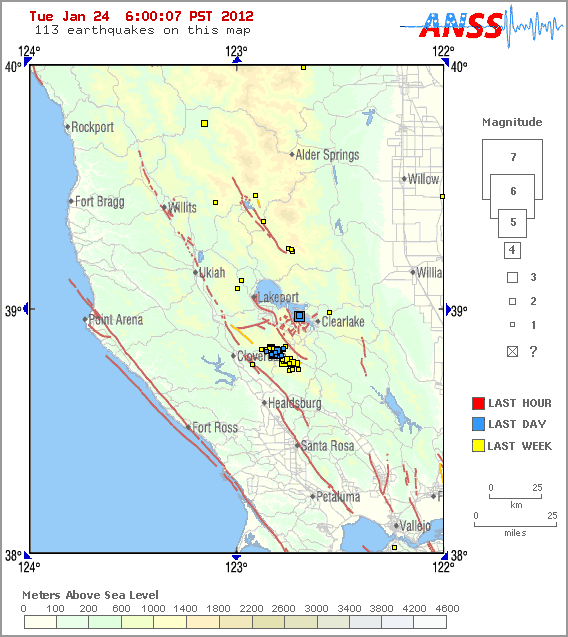
    Just found the location. IN THE LAKE AT THE BASE OF THE VOLCANO, JUST A COUPLE OF MILES AROUND THE CORNER TO MY EAST...

    It is the blue squares in the lake. As you can see, there have already been aftershocks.

    The small cluster of quakes to the SW is The Geysers.

    This is a really bad sign, folks. Not just for me.

    So to be more accurate, the quake was in Kelseyville, California. Home of a living, breathing, freaked-out Druid and a volcano...


    The Earthquake/Seismic Activity Log - Page 25 123-3912


    Mount Konocti (/kɵˈnɒktaɪ/) is a volcano in Lake County, California on the south shore of Clear Lake. At 4,305 feet (1,312 m), it is the second highest peak in the Clear Lake Volcanic Field, which consists of numerous volcanic domes and cones ranging from 10,000 to 2.1 million years old...

    ...The volcano is the most visible landmark in Lake County other than the lake. The mountain is located between the towns of Lakeport and Clearlake. It lies directly south of Soda Bay and Riviera Heights and east of Kelseyville. From the summit of Mount Konocti, the taller peaks and ridges around Snow Mountain can be seen to the northeast...

    http://en.wikipedia.org/wiki/Mount_Konocti
    HigherLove
    HigherLove


    Posts : 2357
    Join date : 2011-01-27
    Age : 59

    The Earthquake/Seismic Activity Log - Page 25 Empty Re: The Earthquake/Seismic Activity Log

    Post  HigherLove Tue Jan 24, 2012 8:25 pm

    Okay, before around the globe:

    1.

    This is a random place to out this, but for those who have been following, the doctor I saw this morning is also not sure what is going on with my arm. She does not think it is related to my nervous system/back or neck injuries. While she sees these as something do deal with, her greatest suspicion at this point is that I may have torn my rotator cuff. I.E.: An MRI is required. That in itself could be thousands of dollars, so I will be doing some juggling.

    Both doctors have said surgery most likely will be required. The problem is, I am not in any pain. I have tenderness when I massage my shoulder area, but otherwise, nothing. ????????

    Another i.e.: nobody seems to understand how possibly I could have done this.

    2. Finish up with Clearlake quake:

    CORRECTION: I had a dyslexic moment and reversed north and south. As such, Clearlake Oaks was the epicenter. However, that only makes a difference of a mile or two (( am about where the top left point of the red arrow is on the above map).

    The Earthquake/Seismic Activity Log - Page 25 01241210


    CLEARLAKE OAKS, Calif. – Residents around the county reported feeling an early morning earthquake that was centered near Clearlake Oaks.


    The U.S. Geological Survey said the 3.8-magnitude quake occurred at 4:11 a.m. at a depth of 1.9 miles.


    It was centered four miles south southwest of Clearlake Oaks, four miles west northwest of Clearlake and six miles northwest of Lower Lake, the agency reported.


    Several residents around the lake – from Clearlake Oaks to Kelseyville – reported feeling the quake, which was said to have lasted about five seconds.


    By 9 a.m. the U.S. Geological Survey had received 233 shake reports from eight zip codes around Northern California, including Clearlake, Clearlake Oaks, Kelseyville, Lakeport, Lower Lake, Middletown, Hidden Valley Lake and Campbell. It also received a report from Sun Valley, Nev.


    A 2.0-magnitude quake was reported in the same spot at 4:29 a.m., according to U.S. Geological Record reports.


    Regarding that second, smaller quake, a total of 19 shake reports were submitted from Clearlake, Clearlake Oaks, Kelseyville and Lower Lake, survey records showed.


    Lake County is seismically active, although most of the earthquake action is reported on Cobb Mountain near The Geysers geothermal steamfield, where increased earthquake activity has been attributed to wastewater injection.


    E-mail Elizabeth Larson at elarson@lakeconews.com . Follow Lake County News on Twitter at http://twitter.com/LakeCoNews, on Tumblr at www.lakeconews.tumblr.com, on Google+, on Facebook at www.facebook.com/pages/Lake-County-News/143156775604?ref=mf and on YouTube at www.youtube.com/user/LakeCoNews .

    http://lakeconews.com/content/view/23351/919/


    HigherLove
    HigherLove


    Posts : 2357
    Join date : 2011-01-27
    Age : 59

    The Earthquake/Seismic Activity Log - Page 25 Empty Re: The Earthquake/Seismic Activity Log

    Post  HigherLove Tue Jan 24, 2012 8:30 pm

    The USGS only list quakes in U.S. of 2.5 or above, and 4.0 for the rest of the world. It may not show up here, but however big or small, 8 out of the last 11 quakes in the world have been in California. Five of them were right here with me.

    MAG UTC DATE-TIME
    y/m/d h:m:s LAT
    deg LON
    deg DEPTH
    km Region
    MAP 5.1 2012/01/25 00:46:00 52.809 -167.095 39.4 FOX ISLANDS, ALEUTIAN ISLANDS, ALASKA
    MAG UTC DATE-TIME
    y/m/d h:m:s LAT
    deg LON
    deg DEPTH
    km Region
    MAP 4.0 2012/01/24 23:54:46 45.555 11.046 6.4 NORTHERN ITALY
    MAP 4.7 2012/01/24 23:34:16 43.337 94.244 9.7 NORTHERN XINJIANG, CHINA
    MAP 4.5 2012/01/24 22:38:35 -0.909 126.787 8.2 MOLUCCA SEA
    MAP 4.2 2012/01/24 22:15:25 19.581 -70.106 10.0 DOMINICAN REPUBLIC
    MAP 4.6 2012/01/24 21:45:23 19.578 -70.067 10.0 DOMINICAN REPUBLIC
    MAP 4.7 2012/01/24 21:33:47 -20.051 -177.647 451.4 FIJI REGION
    MAP 2.5 2012/01/24 21:00:18 61.764 -150.341 54.4 SOUTHERN ALASKA
    MAP 3.4 2012/01/24 20:02:41 18.152 -67.622 146.5 MONA PASSAGE, PUERTO RICO
    MAP 3.6 2012/01/24 18:21:02 30.289 -103.367 5.0 WESTERN TEXAS
    MAP 4.7 2012/01/24 17:35:50 36.792 141.085 17.5 NEAR THE EAST COAST OF HONSHU, JAPAN
    MAP 4.8 2012/01/24 17:07:00 45.994 143.068 338.6 HOKKAIDO, JAPAN REGION
    MAP 4.9 2012/01/24 16:48:22 -41.234 -85.970 10.0 WEST CHILE RISE
    MAP 5.4 2012/01/24 16:31:08 -56.355 -27.930 8.3 SOUTH SANDWICH ISLANDS REGION
    MAP 4.5 2012/01/24 16:26:48 54.884 -159.910 47.9 SOUTH OF ALASKA
    MAP 3.3 2012/01/24 15:46:17 60.084 -153.586 171.8 SOUTHERN ALASKA
    MAP 2.8 2012/01/24 14:43:09 17.931 -65.848 7.4 PUERTO RICO REGION
    MAP 4.5 2012/01/24 14:33:29 19.586 -70.061 2.8 DOMINICAN REPUBLIC
    MAP 4.1 2012/01/24 13:34:51 52.578 -166.983 5.1 FOX ISLANDS, ALEUTIAN ISLANDS, ALASKA
    MAP 3.9 2012/01/24 12:13:26 56.015 -161.330 215.7 ALASKA PENINSULA
    MAP 3.8 2012/01/24 12:11:29 38.969 -122.693 3.4 NORTHERN CALIFORNIA
    MAP 3.3 2012/01/24 11:12:31 19.165 -64.894 6.6 VIRGIN ISLANDS REGION
    MAP 5.2 2012/01/24 10:34:20 8.614 126.143 196.1 MINDANAO, PHILIPPINES
    MAP 2.6 2012/01/24 07:18:14 59.352 -152.658 77.4 SOUTHERN ALASKA
    MAP 3.0 2012/01/24 06:01:29 37.403 -113.875 1.2 UTAH
    MAP 2.5 2012/01/24 03:36:59 39.339 -117.775 10.8 NEVADA
    MAP 4.6 2012/01/24 01:45:28 -34.535 -71.886 34.0 LIBERTADOR O'HIGGINS, CHILE
    MAP 6.3 2012/01/24 00:52:06 -24.959 178.611 582.8 SOUTH OF THE FIJI ISLANDS
    MAP 4.9 2012/01/24 00:33:46 12.606 143.661 19.3 GUAM REGION
    MAP 2.6 2012/01/24 00:21:09 19.381 -155.245 3.3 ISLAND OF HAWAII, HAWAII
    HigherLove
    HigherLove


    Posts : 2357
    Join date : 2011-01-27
    Age : 59

    The Earthquake/Seismic Activity Log - Page 25 Empty Re: The Earthquake/Seismic Activity Log

    Post  HigherLove Wed Jan 25, 2012 2:01 am

    MAP 4.8 2012/01/25 07:33:18 45.881 148.983 158.8 KURIL ISLANDS
    MAP 5.2 2012/01/25 07:17:03 -5.250 152.162 51.9 NEW BRITAIN REGION, PAPUA NEW GUINEA
    MAP 5.1 2012/01/25 06:02:31 -46.940 165.765 9.7 OFF WEST COAST OF THE SOUTH ISLAND, N.Z.
    MAP 2.6 2012/01/25 05:51:40 17.892 -65.203 21.0 PUERTO RICO REGION
    MAP 3.1 2012/01/25 03:25:46 62.073 -147.360 19.5 CENTRAL ALASKA
    MAP 2.5 2012/01/25 03:20:40 36.987 -104.881 5.0 NEW MEXICO
    MAP 4.7 2012/01/25 03:16:02 5.063 127.474 48.3 PHILIPPINE ISLANDS REGION
    MAP 5.1 2012/01/25 00:46:00 52.809 -167.095 39.4 FOX ISLANDS, ALEUTIAN ISLANDS, ALASKA


    The Earthquake/Seismic Activity Log - Page 25 Untitl22

      Current date/time is Mon Nov 18, 2024 10:31 pm