tMoA

Would you like to react to this message? Create an account in a few clicks or log in to continue.
tMoA

~ The only Home on the Web You'll ever need ~

+21
Aquaries1111
giovonni
arvan33
Floyd
lawlessline
JesterTerrestrial
THEeXchanger
newel
Brook
greybeard
Mercuriel
Sanicle
devakas
hobbit
mudra
burgundia
lindabaker
LeeEllisMusic
MargueriteBee
Carol
HigherLove
25 posters

    The Earthquake/Seismic Activity Log

    HigherLove
    HigherLove


    Posts : 2357
    Join date : 2011-01-27
    Age : 59

    The Earthquake/Seismic Activity Log - Page 9 Empty Re: The Earthquake/Seismic Activity Log

    Post  HigherLove Sun May 08, 2011 10:43 am

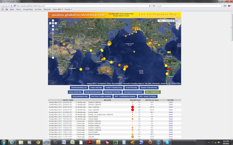
    It makes me cringe a little to say it, but the world has been relatively quiet, in terms of large quakes. The smaller ones, however, are all over the map. In the U.S. there have been small quakes in Arkansas, Texas, Tennessee, and the "Greater New York/New Jersey area" (something not seen very often on the logs).

    Magnitude
    1.2
    Date-Time
    Sunday, May 08, 2011 at 12:32:00 UTC
    Sunday, May 08, 2011 at 08:32:00 AM at epicenter
    Location
    40.854°N, 74.170°W
    Depth
    5.6 km (3.5 miles) set by location program
    Region
    GREATER NEW YORK AREA, NEW JERSEY
    Distances
    2 km (1 miles) SW (220°) from Clifton, NJ
    3 km (2 miles) W (264°) from Passaic, NJ
    4 km (2 miles) NNW (346°) from Nutley, NJ
    7 km (4 miles) S (185°) from Paterson, NJ
    27 km (17 miles) NW (308°) from New York, NY
    Location Uncertainty
    Error estimate not available
    Parameters
    Nph= 16, Dmin=0 km, Rmss=0 sec, Gp= 0,
    M-type=duration magnitude (Md), Version=1
    Source
    Lamont-Doherty Cooperative Seismographic Network (LCSN)
    Event ID
    ld60015926

    _______________________________________

    MAP 1.7 2011/05/08 15:25:10 38.822 -122.787 3.5 3 km ( 2 mi) NE of The Geysers, CA
    MAP 2.2 2011/05/08 15:16:20 61.545 -141.265 0.0 70 km ( 43 mi) SE of Chisana, AK
    MAP 2.6 2011/05/08 14:48:45 66.175 -141.796 62.3 101 km ( 63 mi) ESE of Chalkyitsik, AK
    MAP 1.3 2011/05/08 14:27:11 32.994 -116.348 13.0 24 km ( 15 mi) ESE of Julian, CA
    MAP 2.0 2011/05/08 14:11:17 59.062 -153.575 81.8 76 km ( 47 mi) SE of Pope-Vannoy Landing, AK
    MAP 3.2 2011/05/08 13:57:58 30.700 -105.783 10.0 66 km ( 41 mi) S of Fort Hancock, TX
    MAP 3.4 2011/05/08 13:46:16 30.705 -105.765 10.0 66 km ( 41 mi) S of Fort Hancock, TX
    MAP 1.0 2011/05/08 13:41:32 64.395 -148.026 15.5 50 km ( 31 mi) WSW of Eielson AFB, AK
    MAP 3.3 2011/05/08 13:24:49 30.698 -105.838 10.0 66 km ( 41 mi) S of Fort Hancock, TX
    MAP 1.8 2011/05/08 13:17:40 35.639 -83.964 13.6 12 km ( 8 mi) S of Maryville, TN
    MAP 2.9 2011/05/08 12:53:56 62.834 -150.791 100.1 51 km ( 32 mi) N of Petersville, AK
    MAP 1.8 2011/05/08 12:37:45 33.796 -116.156 9.8 11 km ( 7 mi) NE of Indio, CA
    MAP 1.2 2011/05/08 12:32:00 40.854 -74.170 5.6 2 km ( 1 mi) SW of Clifton, NJ
    MAP 1.8 2011/05/08 11:38:12 61.506 -146.573 65.3 45 km ( 28 mi) NNW of Valdez, AK
    MAP 2.7 2011/05/08 11:32:44 39.014 -111.320 0.1 12 km ( 7 mi) NNW of Emery, UT
    MAP 2.0 2011/05/08 11:06:50 35.361 -118.464 10.6 17 km ( 11 mi) NE of Keene, CA
    MAP 1.3 2011/05/08 10:56:52 38.794 -122.780 3.8 2 km ( 1 mi) E of The Geysers, CA
    MAP 2.1 2011/05/08 10:09:07 59.488 -152.865 96.4 56 km ( 35 mi) WNW of Nanwalek, AK
    MAP 1.4 2011/05/08 10:04:34 35.727 -121.112 7.3 12 km ( 7 mi) NE of San Simeon, CA
    MAP 1.3 2011/05/08 08:53:08 60.177 -141.147 18.8 107 km ( 67 mi) NW of Yakutat, AK
    MAP 2.8 2011/05/08 08:16:52 63.087 -155.869 7.6 17 km ( 10 mi) NE of Takotna, AK
    MAP 1.4 2011/05/08 08:13:10 36.262 -116.584 5.3 16 km ( 10 mi) WSW of Death Valley Junction, CA
    MAP 2.5 2011/05/08 08:12:37 33.909 -116.780 18.6 1 km ( 1 mi) W of Cabazon, CA
    MAP 1.0 2011/05/08 07:14:57 37.148 -117.488 21.2 18 km ( 11 mi) NW of Scottys Castle, CA
    MAP 1.6 2011/05/08 06:51:53 37.142 -117.384 7.1 13 km ( 8 mi) NNW of Scottys Castle, CA
    MAP 1.0 2011/05/08 06:10:48 64.940 -149.251 17.4 25 km ( 15 mi) SSE of Minto, AK
    MAP 2.4 2011/05/08 06:01:23 62.290 -141.229 0.0 45 km ( 28 mi) S of Alcan Border, AK
    MAP 2.5 2011/05/08 05:59:12 35.356 -118.457 8.8 17 km ( 11 mi) NE of Keene, CA
    MAP 1.4 2011/05/08 05:14:15 38.804 -122.811 2.2 1 km ( 0 mi) NNW of The Geysers, CA
    MAP 3.3 2011/05/08 04:32:20 44.818 -110.992 6.6 19 km ( 12 mi) NNE of West Yellowstone, MT
    MAP 1.3 2011/05/08 04:27:34 64.127 -148.357 11.7 32 km ( 20 mi) ENE of Ferry, AK
    MAP 1.4 2011/05/08 04:17:09 33.348 -116.373 22.8 11 km ( 7 mi) N of Borrego Springs, CA
    MAP 1.6 2011/05/08 03:49:44 34.010 -117.238 16.3 4 km ( 3 mi) SSE of Loma Linda, CA
    MAP 1.1 2011/05/08 03:36:44 33.786 -116.151 5.6 10 km ( 7 mi) NE of Indio, CA
    MAP 2.0 2011/05/08 03:36:06 63.366 -147.429 57.5 73 km ( 46 mi) E of Cantwell, AK
    MAP 1.8 2011/05/08 03:24:02 38.837 -122.824 2.4 5 km ( 3 mi) NNW of The Geysers, CA
    MAP 2.4 2011/05/08 03:22:08 38.779 -122.744 0.0 5 km ( 3 mi) W of Anderson Springs, CA
    MAP 2.3 2011/05/08 02:23:49 38.837 -122.825 2.5 5 km ( 3 mi) NNW of The Geysers, CA
    MAP 1.4 2011/05/08 02:23:33 35.956 -117.657 5.6 28 km ( 17 mi) ESE of Coso Junction, CA
    MAP 1.5 2011/05/08 01:36:01 38.803 -122.811 3.4 1 km ( 0 mi) NW of The Geysers, CA
    MAP 2.5 2011/05/08 01:30:29 62.097 -148.529 25.6 34 km ( 21 mi) N of Chickaloon, AK
    MAP 2.9 2011/05/08 01:29:52 17.680 -64.786 17.2 7 km ( 5 mi) SE of Grove Place, US Virgin Islands
    MAP 1.3 2011/05/08 01:16:18 62.952 -149.333 75.3 53 km ( 33 mi) SSW of Cantwell, AK
    MAP 2.0 2011/05/08 00:46:00 62.952 -151.139 117.7 67 km ( 42 mi) NNW of Petersville, AK
    MAP 1.2 2011/05/08 00:35:36 62.270 -150.690 60.4 12 km ( 8 mi) SSE of Petersville, AK
    MAP 1.4 2011/05/08 00:24:39 33.737 -116.050 5.7 13 km ( 8 mi) ENE of Coachella, CA
    HigherLove
    HigherLove


    Posts : 2357
    Join date : 2011-01-27
    Age : 59

    The Earthquake/Seismic Activity Log - Page 9 Empty Re: The Earthquake/Seismic Activity Log

    Post  HigherLove Sun May 08, 2011 4:16 pm

    The Earthquake/Seismic Activity Log - Page 9 Untitl26

    MAP 4.9 2011/05/08 20:46:18 -23.195 -66.337 223.9 JUJUY, ARGENTINA
    MAP 2.9 2011/05/08 19:32:20 62.486 -153.179 0.0 CENTRAL ALASKA
    MAP 2.7 2011/05/08 18:38:55 33.186 -116.040 9.4 SOUTHERN CALIFORNIA
    MAP 2.7 2011/05/08 17:43:27 54.902 -160.370 22.7 ALASKA PENINSULA
    MAP 4.6 2011/05/08 17:33:14 -13.630 167.173 218.9 VANUATU
    MAP 5.0 2011/05/08 15:51:39 1.043 125.336 84.4 MOLUCCA SEA
    MAP 4.2 2011/05/08 15:20:50 37.144 140.682 40.9 EASTERN HONSHU, JAPAN
    MAP 2.6 2011/05/08 14:48:45 66.175 -141.796 62.3 NORTHERN ALASKA
    MAP 4.6 2011/05/08 14:46:05 39.783 143.069 45.4 OFF THE EAST COAST OF HONSHU, JAPAN
    MAP 3.2 2011/05/08 13:57:58 30.700 -105.783 10.0 CHIHUAHUA, MEXICO
    MAP 3.4 2011/05/08 13:46:16 30.705 -105.765 10.0 CHIHUAHUA, MEXICO
    MAP 4.8 2011/05/08 13:28:43 38.475 142.690 40.7 NEAR THE EAST COAST OF HONSHU, JAPAN
    MAP 3.3 2011/05/08 13:24:49 30.698 -105.838 10.0 CHIHUAHUA, MEXICO
    MAP 2.9 2011/05/08 12:53:56 62.834 -150.791 100.1 CENTRAL ALASKA
    MAP 2.7 2011/05/08 11:32:44 39.014 -111.320 0.1 UTAH
    MAP 4.8 2011/05/08 10:42:55 37.620 141.539 53.5 NEAR THE EAST COAST OF HONSHU, JAPAN
    MAP 3.4 2011/05/08 09:47:11 42.009 21.252 5.0 MACEDONIA
    MAP 4.6 2011/05/08 09:00:25 38.630 143.252 23.5 OFF THE EAST COAST OF HONSHU, JAPAN
    MAP 3.0 2011/05/08 08:16:37 62.617 -157.925 20.9 CENTRAL ALASKA
    MAP 2.5 2011/05/08 08:12:37 33.909 -116.780 18.6 SOUTHERN CALIFORNIA
    MAP 5.1 2011/05/08 06:50:25 36.600 27.227 16.3 DODECANESE ISLANDS, GREECE
    HigherLove
    HigherLove


    Posts : 2357
    Join date : 2011-01-27
    Age : 59

    The Earthquake/Seismic Activity Log - Page 9 Empty Re: The Earthquake/Seismic Activity Log

    Post  HigherLove Mon May 09, 2011 3:22 pm

    Magnitude
    5.8
    Date-Time
    Monday, May 09, 2011 at 19:13:27 UTC
    Tuesday, May 10, 2011 at 03:13:27 AM at epicenter
    Time of Earthquake in other Time Zones
    Location
    5.384°N, 126.472°E
    Depth
    35.7 km (22.2 miles)
    Region
    MINDANAO, PHILIPPINES
    Distances
    165 km (102 miles) ESE of General Santos, Mindanao, Philippines
    209 km (129 miles) SSE of Davao, Mindanao, Philippines
    913 km (567 miles) WSW of KOROR, Palau
    1184 km (735 miles) SSE of MANILA, Philippines
    Location Uncertainty
    horizontal +/- 16.2 km (10.1 miles); depth +/- 6.7 km (4.2 miles)
    Parameters
    NST=130, Nph=136, Dmin=821.5 km, Rmss=1.33 sec, Gp= 76°,
    M-type=regional moment magnitude (Mw), Version=7
    Source
    USGS NEIC (WDCS-D)
    Event ID
    usc00039t8


    Magnitude
    6.3
    Date-Time
    Monday, May 09, 2011 at 18:54:42 UTC
    Tuesday, May 10, 2011 at 04:54:42 AM at epicenter
    Time of Earthquake in other Time Zones
    Location
    56.612°S, 147.837°E
    Depth
    1 km (~0.6 mile) (poorly constrained)
    Region
    WEST OF MACQUARIE ISLAND
    Distances
    730 km (453 miles) WSW of Macquarie Island, Australia
    1192 km (740 miles) NNE of Dumont d'Urville, Antarctica
    1523 km (946 miles) S of HOBART, Tasmania, Australia
    2100 km (1304 miles) S of MELBOURNE, Victoria, Australia
    Location Uncertainty
    horizontal +/- 16.7 km (10.4 miles); depth +/- 5.3 km (3.3 miles)
    Parameters
    NST= 76, Nph= 82, Dmin=740.3 km, Rmss=1.82 sec, Gp= 76°,
    M-type=teleseismic moment magnitude (Mw), Version=9
    Source
    USGS NEIC (WDCS-D)
    Event ID
    usc00039sb

    The Earthquake/Seismic Activity Log - Page 9 Untitl27

    MAP 5.8 2011/05/09 19:13:27 5.384 126.472 35.7 MINDANAO, PHILIPPINES
    MAP 4.9 2011/05/09 19:05:00 54.930 -160.225 24.3 ALASKA PENINSULA
    MAP 6.3 2011/05/09 18:54:43 -56.612 147.837 1.0 WEST OF MACQUARIE ISLAND
    MAP 2.5 2011/05/09 18:33:07 32.368 -115.523 2.7 BAJA CALIFORNIA, MEXICO
    MAP 2.7 2011/05/09 17:58:22 32.553 -115.718 3.0 BAJA CALIFORNIA, MEXICO
    MAP 4.6 2011/05/09 17:27:26 5.119 94.137 55.2 NORTHERN SUMATRA, INDONESIA
    MAP 5.0 2011/05/09 15:04:23 -43.588 172.495 16.5 SOUTH ISLAND OF NEW ZEALAND
    MAP 4.5 2011/05/09 14:52:41 27.155 143.402 36.4 BONIN ISLANDS, JAPAN REGION
    MAP 3.1 2011/05/09 14:46:43 46.185 -75.193 18.0 SOUTHERN QUEBEC, CANADA
    MAP 3.3 2011/05/09 14:36:47 38.795 -122.778 4.0 NORTHERN CALIFORNIA
    MAP 2.7 2011/05/09 13:06:19 33.273 -116.282 8.3 SOUTHERN CALIFORNIA
    MAP 3.8 2011/05/09 12:30:59 50.785 179.365 40.5 RAT ISLANDS, ALEUTIAN ISLANDS, ALASKA
    MAP 2.6 2011/05/09 12:29:32 38.405 -118.727 4.7 NEVADA
    MAP 4.5 2011/05/09 12:16:05 47.111 144.616 403.6 SEA OF OKHOTSK
    MAP 4.5 2011/05/09 12:08:21 36.227 140.849 25.3 NEAR THE EAST COAST OF HONSHU, JAPAN
    MAP 2.7 2011/05/09 11:59:26 18.631 -67.536 11.5 PUERTO RICO REGION
    MAP 3.9 2011/05/09 09:46:24 38.424 -118.736 2.1 NEVADA
    MAP 3.4 2011/05/09 09:11:36 18.132 -68.551 89.5 MONA PASSAGE, DOMINICAN REPUBLIC
    MAP 4.4 2011/05/09 08:44:41 13.174 -90.041 45.1 OFFSHORE EL SALVADOR
    MAP 2.7 2011/05/09 08:27:48 33.468 -116.579 10.4 SOUTHERN CALIFORNIA
    MAP 4.5 2011/05/09 08:09:20 -3.686 99.465 26.4 SOUTHWEST OF SUMATRA, INDONESIA
    MAP 3.8 2011/05/09 06:40:19 30.807 -105.719 10.0 CHIHUAHUA, MEXICO
    MAP 3.0 2011/05/09 04:44:20 51.891 -173.094 32.2 ANDREANOF ISLANDS, ALEUTIAN IS., ALASKA
    MAP 2.6 2011/05/09 04:04:28 59.643 -152.637 80.9 SOUTHERN ALASKA
    MAP 2.6 2011/05/09 03:29:29 54.856 -162.503 93.1 ALASKA PENINSULA
    MAP 4.5 2011/05/09 03:21:48 19.069 145.363 204.9 MAUG ISLANDS REG., NORTHERN MARIANA ISL.
    MAP 2.6 2011/05/09 01:27:22 18.363 -64.947 18.3 SAINT THOMAS, U.S. VIRGIN ISLANDS
    HigherLove
    HigherLove


    Posts : 2357
    Join date : 2011-01-27
    Age : 59

    The Earthquake/Seismic Activity Log - Page 9 Empty Re: The Earthquake/Seismic Activity Log

    Post  HigherLove Mon May 09, 2011 3:36 pm

    Another 5.8 off of Honshu.

    Things are picking up, again.
    mudra
    mudra


    Posts : 23307
    Join date : 2010-04-09
    Age : 70
    Location : belgium

    The Earthquake/Seismic Activity Log - Page 9 Empty Re: The Earthquake/Seismic Activity Log

    Post  mudra Tue May 10, 2011 4:18 am

    Magnitude Mw 7.1
    Region LOYALTY ISLANDS
    Date time 2011-05-10 08:55:12.0 UTC
    Location 20.23 S ; 168.22 E
    Depth 30 km
    Distances 1097 km W Suva (pop 199,455 ; local time 20:55:12.2 2011-05-10)
    127 km NE Wé (pop 10,375 ; local time 19:55:12.2 2011-05-10)

    Love Always
    mudra


    Last edited by mudra on Tue Jul 19, 2011 6:49 pm; edited 1 time in total
    HigherLove
    HigherLove


    Posts : 2357
    Join date : 2011-01-27
    Age : 59

    The Earthquake/Seismic Activity Log - Page 9 Empty Re: The Earthquake/Seismic Activity Log

    Post  HigherLove Tue May 10, 2011 4:31 am

    mudra wrote:Magnitude Mw 7.1
    Region LOYALTY ISLANDS
    Date time 2011-05-10 08:55:12.0 UTC
    Location 20.23 S ; 168.22 E
    Depth 30 km
    Distances 1097 km W Suva (pop 199,455 ; local time 20:55:12.2 2011-05-10)
    127 km NE Wé (pop 10,375 ; local time 19:55:12.2 2011-05-10)

    The Earthquake/Seismic Activity Log - Page 9 CSEMbm647.global

    Love Always
    mudra

    Magnitude 7.1
    Date-Time

    Tuesday, May 10, 2011 at 08:55:11 UTC
    Tuesday, May 10, 2011 at 07:55:11 PM at epicenter
    Time of Earthquake in other Time Zones

    Location 20.229°S, 168.204°E
    Depth 26.5 km (16.5 miles)
    Region LOYALTY ISLANDS
    Distances 134 km (83 miles) SW of Isangel, Tanna, Vanuatu
    149 km (92 miles) NNE of Tadine, Loyalty Islands, New Caledonia
    276 km (171 miles) S of PORT-VILA, Efate, Vanuatu
    1741 km (1081 miles) ENE of BRISBANE, Queensland, Australia
    Location Uncertainty horizontal +/- 14.7 km (9.1 miles); depth +/- 10.1 km (6.3 miles)
    Parameters NST= 76, Nph= 77, Dmin=>999 km, Rmss=1.01 sec, Gp= 32°,
    M-type=regional moment magnitude (Mw), Version=7
    Source

    USGS NEIC (WDCS-D)

    Event ID usc0003ag4
    HigherLove
    HigherLove


    Posts : 2357
    Join date : 2011-01-27
    Age : 59

    The Earthquake/Seismic Activity Log - Page 9 Empty Re: The Earthquake/Seismic Activity Log

    Post  HigherLove Tue May 10, 2011 4:33 am

    HigherLove wrote:
    Vanuatu


    http://en.wikipedia.org/wiki/Vanuatu


    Recent earthquakes near Vanuatu
    Time Magnitude Location
    1 hour ago 5.0 Vanuatu Map
    2 days ago 5.2 Vanuatu region Map
    3 days ago 5.9 Solomon Islands Map


    earthquake.usgs.gov
    ____________

    HigherLove
    HigherLove


    Posts : 2357
    Join date : 2011-01-27
    Age : 59

    The Earthquake/Seismic Activity Log - Page 9 Empty Re: The Earthquake/Seismic Activity Log

    Post  HigherLove Tue May 10, 2011 4:39 am

    Earthquakes list May 10, 2011
    Very dangerous : LOYALTY ISLANDS

    http://earthquake-report.com/

    EDIT/UPDATE:

    Earthquakes list May 10, 2011
    Not dangerous : New Zealand, Philippines, Japan (aftershocks), Indian Ocean, Mariana Islands, Chile, New Caledonia / Vanuatu


    Last edited by HigherLove on Tue May 10, 2011 5:19 am; edited 1 time in total
    HigherLove
    HigherLove


    Posts : 2357
    Join date : 2011-01-27
    Age : 59

    The Earthquake/Seismic Activity Log - Page 9 Empty Re: The Earthquake/Seismic Activity Log

    Post  HigherLove Tue May 10, 2011 4:44 am


    Geology of New Caledonia


    The Earthquake/Seismic Activity Log - Page 9 Struct10


    Grande Terre and smaller islands extending northward and southward, are emerging parts of a folded arc (Grande Terre Arc on the map). East of this arc, Loyalty islands are on a volcanic arc (Loyalty Is. Arc).

    They are set on the Australian Plate which drifts eastward under (subduction) the Pacific Plate. East of this subduction line Vanuatu is on another volcanic arc, the New-Hebrides Arc.

    Grande Terre arc consists mostly in sedimentary, volcanic and ultrabasic rocks from Permian (225-280 millions years) to Tertiary (1,5 - 65 MY). Some geological formations in the main central ranges could be older than Permian but their age has not been established yet. The important group of ultrabasic rocks of Tertiary age relate to a mantle sheet (mantle is a thick layer located under the Earth crust and above its core) overthrust on the other geological formations (obduction). Vast areas of volcanic rocks (basalt), on the West Coast, are spatially associated with the ultrabasic rocks. They are remnants of an oceanic floor obducted before the overthrust of ultrabasics. Several ages of folding have been established. The last one occurred during Eocene to Oligocene (26-53 MA) and created the actual island. These folding and obductions are the result of colliding plates. These plate collisions generated temperatures and pressures which led to a transformation of sediments and volcanics. Such metamorphism has formed schists, micaschists and the interesting glaucophane and garnet bearing blue rocks in the North of Grand Terre. This blueschist metamorphism requires very high pressure and is seldom occurring so extensively in other parts of the world.

    In the Eastern Loyalty Arc, Loyalty islands are set upon volcanoes. Initially these volcanoes were emerged and surrounded by coral reefs. They progressively sunk in the ocean while coral kept growing up creating a coral ring which evolved in an atoll when the volcanic island eventually sunk entirely under sea. The lagoon enclosed in the coral ring filled up with coral sediments and coral reefs. During Quaternary these filled up lagoons were upraised, creating the actual coral limestone islands.

    http://www.croixdusud.info/eng/geo_eng/nc_geol_eng.php

    The Earthquake/Seismic Activity Log - Page 9 Untitl28


    mudra
    mudra


    Posts : 23307
    Join date : 2010-04-09
    Age : 70
    Location : belgium

    The Earthquake/Seismic Activity Log - Page 9 Empty Re: The Earthquake/Seismic Activity Log

    Post  mudra Tue May 10, 2011 5:10 am

    M7.1 hits Loyalty Islands near New Caledonia, Vanuatu

    https://www.youtube.com/watch?v=RRSiR88Ea6I&feature=player_embedded


    Love Always
    mudra
    HigherLove
    HigherLove


    Posts : 2357
    Join date : 2011-01-27
    Age : 59

    The Earthquake/Seismic Activity Log - Page 9 Empty Re: The Earthquake/Seismic Activity Log

    Post  HigherLove Tue May 10, 2011 5:29 am

    HigherLove wrote:Earthquakes list May 10, 2011
    Very dangerous : LOYALTY ISLANDS

    http://earthquake-report.com/

    EDIT/UPDATE:

    Earthquakes list May 10, 2011
    Not dangerous : New Zealand, Philippines, Japan (aftershocks), Indian Ocean, Mariana Islands, Chile, New Caledonia / Vanuatu
    HigherLove
    HigherLove


    Posts : 2357
    Join date : 2011-01-27
    Age : 59

    The Earthquake/Seismic Activity Log - Page 9 Empty Re: The Earthquake/Seismic Activity Log

    Post  HigherLove Tue May 10, 2011 3:38 pm

    The Loyalty Islands have already had 10 aftershocks that were 5.0 or larger, and one that was 4.9. This area is full of volcanoes.

    NOTE: unlike the other subduction zones on the ring of fire, in the case of the Loyalty Islands, it is the Australian plate getting shoved under the Pacific plate. It is usually the Pacific plate that is subducted, so this is a rarity (the geology, not the quakes).
    ________________________________________________

    MAP 5.2 2011/05/10 19:31:51 -20.153 168.363 52.9 LOYALTY ISLANDS
    MAP 3.6 2011/05/10 18:41:19 30.840 -105.732 16.1 CHIHUAHUA, MEXICO
    MAP 3.5 2011/05/10 18:21:52 38.293 -118.181 15.8 NEVADA
    MAP 4.5 2011/05/10 17:02:15 35.660 140.863 18.9 NEAR THE EAST COAST OF HONSHU, JAPAN
    MAP 5.0 2011/05/10 16:45:45 -4.713 -105.457 10.0 CENTRAL EAST PACIFIC RISE
    MAP 4.7 2011/05/10 16:12:36 36.794 142.011 22.1 OFF THE EAST COAST OF HONSHU, JAPAN
    MAP 5.4 2011/05/10 15:26:06 43.281 130.999 557.5 JILIN-HEILONGJIANG BORDER REGION, CHINA
    MAP 5.0 2011/05/10 15:10:03 -20.067 168.273 35.0 LOYALTY ISLANDS
    MAP 5.0 2011/05/10 15:05:22 -4.790 -105.582 10.0 CENTRAL EAST PACIFIC RISE
    MAP 5.1 2011/05/10 14:53:35 -20.162 168.193 42.7 LOYALTY ISLANDS
    MAP 2.6 2011/05/10 14:40:55 34.273 -116.451 6.5 SOUTHERN CALIFORNIA
    MAP 5.1 2011/05/10 14:32:36 1.490 126.372 41.7 MOLUCCA SEA
    MAP 5.3 2011/05/10 14:07:49 -20.256 168.193 39.5 LOYALTY ISLANDS
    MAP 4.2 2011/05/10 14:01:55 34.146 135.220 14.8 NEAR S. COAST OF WESTERN HONSHU, JAPAN
    MAP 3.0 2011/05/10 13:59:00 18.969 -66.732 35.4 PUERTO RICO REGION
    MAP 5.0 2011/05/10 13:03:03 -55.926 -27.354 92.5 SOUTH SANDWICH ISLANDS REGION
    MAP 5.0 2011/05/10 12:07:37 -20.191 168.428 20.5 LOYALTY ISLANDS
    MAP 5.3 2011/05/10 12:00:32 -20.074 168.324 21.7 LOYALTY ISLANDS
    MAP 5.2 2011/05/10 11:31:48 -20.158 168.339 20.4 LOYALTY ISLANDS
    MAP 5.5 2011/05/10 10:44:12 -20.235 168.373 35.4 LOYALTY ISLANDS
    MAP 5.2 2011/05/10 10:37:15 -20.252 168.310 35.2 LOYALTY ISLANDS
    MAP 5.7 2011/05/10 10:24:22 -20.339 168.353 35.8 LOYALTY ISLANDS
    MAP 5.2 2011/05/10 10:14:42 36.302 141.618 24.9 NEAR THE EAST COAST OF HONSHU, JAPAN
    MAP 4.9 2011/05/10 10:14:25 -20.387 168.138 35.3 LOYALTY ISLANDS
    MAP 3.1 2011/05/10 09:40:13 47.459 -114.003 23.4 WESTERN MONTANA
    MAP 6.8 2011/05/10 08:55:10 -20.252 168.273 14.9 LOYALTY ISLANDS
    HigherLove
    HigherLove


    Posts : 2357
    Join date : 2011-01-27
    Age : 59

    The Earthquake/Seismic Activity Log - Page 9 Empty Re: The Earthquake/Seismic Activity Log

    Post  HigherLove Tue May 10, 2011 3:46 pm

    Massive earthquake between New Caledonia and Vanuatu


    The Earthquake/Seismic Activity Log - Page 9 Neic_c10

    UPDATE 19:01 UTC : Dianne Hambrook in Port Vila, Vanuatu experience report : “We definitely felt that one! The 7.1 in the Loyalty Islands (it didn’t seem that strong but it was quite a long way away). A kind of gentle, rocking and rolling motion that went on for a long time.

    We were watching a play and the actors never missed a beat. They carried on performing as if nothing was happening. Impressively professional. Several members of the audience vacated the theatre for the duration though”.

    The reports I read said “potentially affecting zero people”. Right!

    UPDATE 11:15 UTC : Seismological bureaus have lowered the magnitude from the initial 7.1 to 6.8, seemingly nothing but in earthquake terms a big difference in energy.

    UPDATE 11:13 UTC : As expected the first strong aftershock (5.7 magnitude) occurred a little while ago. There might be some very strong aftershocks to follow, but the aftershocks will be normally harmless and will be gradually winding down from very strong, to strong, to moderate. We will publish the +4.5 aftershocks in our daily earthquake overview, just like we do for the Japan Tohoku earthquake.

    UPDATE 10:48 UTC : A reader living in Noumea, New Caledonia reports : I was sitting at a table at an outdoor restaurant and felt weak shaking. MMI II to III

    UPDATE 10:27 UTC : Here is the USGS description of the tectonic elements that triggered a similar earthquake in the same area in December 2010. The forces that generated today’s earthquake are the same :
    The Vanuatu (New Hebrides trench) earthquake of December 25, 2010, occurred as the result of normal-faulting within the Australia plate, in the region of the boundary between the Australia plate and the Pacific plate. In the epicentral region of the earthquake, the Australia plate moves east-northeast relative to the Pacific plate with a velocity of about 8 cm/yr.

    The Australia plate subducts beneath the Pacific plate at the New Hebrides trench and is seismically active northeast of the epicenter of the December 25 earthquake to a depth of 300 km.
    The stresses that generated the earthquake result from the bending of the Australia plate as it subducts beneath the Pacific plate.

    The New Hebrides arc region of the Australia/New Hebrides plate-boundary experiences numerous strong earthquakes.

    In the past quarter century, the thousand kilometer section of the arc centered on the epicenter of the December 25 earthquake has produced 19 earthquakes of magnitude 7 or greater, the largest having magnitude 7.7.

    The western margin of the Pacific plate that lies to the east of the New Hebrides trench is commonly viewed as being subdivided into several microplates that move with respect to each other at rates of a few cm/yr. http://earthquake-report.com/2011/05/10/massive-earthquake-between-new-caledonia-and-vanuatu/

    UPDATE : Earthquake-Report Update Video from Robert Speta based on the content from this article
    HigherLove
    HigherLove


    Posts : 2357
    Join date : 2011-01-27
    Age : 59

    The Earthquake/Seismic Activity Log - Page 9 Empty Re: The Earthquake/Seismic Activity Log

    Post  HigherLove Tue May 10, 2011 3:49 pm

    <iframe width="560" height="349" src="https://www.youtube.com/embed/iMTa8gDMmt0" frameborder="0" allowfullscreen></iframe>
    hobbit
    hobbit


    Posts : 137
    Join date : 2010-04-26

    The Earthquake/Seismic Activity Log - Page 9 Empty Ding dong

    Post  hobbit Wed May 11, 2011 3:30 pm

    It's the bells, the bells?
    http://www.bbc.co.uk/news/world-europe-13368599
    hobbit
    HigherLove
    HigherLove


    Posts : 2357
    Join date : 2011-01-27
    Age : 59

    The Earthquake/Seismic Activity Log - Page 9 Empty Re: The Earthquake/Seismic Activity Log

    Post  HigherLove Wed May 11, 2011 5:20 pm

    hobbit wrote:It's the bells, the bells?
    http://www.bbc.co.uk/news/world-europe-13368599
    hobbit

    Thanks, Hobbit!

    _________________________________

    MAP 2.9 2011/05/11 20:48:58 40.306 -124.574 16.5 OFFSHORE NORTHERN CALIFORNIA
    MAP 3.4 2011/05/11 20:39:16 59.978 -153.324 135.8 SOUTHERN ALASKA
    MAP 2.6 2011/05/11 19:26:51 34.944 -118.048 7.4 SOUTHERN CALIFORNIA
    MAP 3.9 2011/05/11 19:06:15 37.057 -104.695 5.0 COLORADO
    MAP 5.5 2011/05/11 18:14:36 36.068 142.217 35.5 OFF THE EAST COAST OF HONSHU, JAPAN
    MAP 2.7 2011/05/11 17:37:58 63.608 -146.227 13.0 CENTRAL ALASKA
    MAP 4.2 2011/05/11 16:51:31 -6.921 130.267 132.4 BANDA SEA
    MAP 5.1 2011/05/11 16:47:26 37.699 -1.673 1.0 SPAIN
    MAP 5.0 2011/05/11 15:59:13 -17.455 -172.493 39.2 TONGA REGION
    MAP 4.9 2011/05/11 15:33:09 -6.504 147.869 49.0 EASTERN NEW GUINEA REG, PAPUA NEW GUINEA
    MAP 5.0 2011/05/11 15:21:26 -6.544 147.806 47.7 EASTERN NEW GUINEA REG, PAPUA NEW GUINEA
    MAP 4.5 2011/05/11 15:05:13 37.693 -1.673 0.0 SPAIN
    MAP 4.8 2011/05/11 14:17:11 36.311 142.488 35.0 OFF THE EAST COAST OF HONSHU, JAPAN
    MAP 2.6 2011/05/11 14:05:01 59.789 -151.655 37.3 KENAI PENINSULA, ALASKA
    MAP 2.9 2011/05/11 11:57:27 36.597 -121.109 8.9 CENTRAL CALIFORNIA
    MAP 5.0 2011/05/11 10:39:39 -20.395 168.330 37.2 LOYALTY ISLANDS
    MAP 5.1 2011/05/11 10:32:26 -20.399 168.410 44.9 LOYALTY ISLANDS
    MAP 4.9 2011/05/11 09:43:32 -20.406 168.299 44.0 LOYALTY ISLANDS
    MAP 5.1 2011/05/11 09:21:37 -20.348 168.345 38.7 LOYALTY ISLANDS
    MAP 5.2 2011/05/11 09:16:26 -20.294 168.267 37.9 LOYALTY ISLANDS
    MAP 5.7 2011/05/11 08:19:39 -20.392 168.320 45.6 LOYALTY ISLANDS
    MAP 2.8 2011/05/11 08:09:09 37.388 -118.687 14.6 CENTRAL CALIFORNIA
    MAP 3.3 2011/05/11 08:06:26 37.389 -118.686 14.3 CENTRAL CALIFORNIA
    MAP 2.7 2011/05/11 07:59:33 18.581 -66.589 74.5 PUERTO RICO REGION
    MAP 5.1 2011/05/11 07:54:31 1.518 127.239 99.2 HALMAHERA, INDONESIA
    MAP 4.9 2011/05/11 06:46:15 -20.344 168.245 42.0 LOYALTY ISLANDS
    MAP 5.3 2011/05/11 06:11:28 -36.385 -179.565 42.6 EAST OF THE NORTH ISLAND, NEW ZEALAND
    MAP 4.8 2011/05/11 05:47:17 -7.132 155.636 90.4 SOLOMON ISLANDS
    MAP 2.7 2011/05/11 05:35:27 53.560 -164.663 44.5 UNIMAK ISLAND REGION, ALASKA
    MAP 4.8 2011/05/11 04:37:31 -38.446 177.710 81.6 NORTH ISLAND OF NEW ZEALAND
    MAP 4.9 2011/05/11 03:13:00 -19.939 168.575 9.9 VANUATU
    MAP 4.5 2011/05/11 02:30:05 -20.125 -68.593 116.0 POTOSI, BOLIVIA
    MAP 5.0 2011/05/11 01:28:08 6.067 126.002 104.8 MINDANAO, PHILIPPINES
    MAP 5.6 2011/05/11 01:20:08 37.811 143.561 25.1 OFF THE EAST COAST OF HONSHU, JAPAN
    MAP 4.7 2011/05/11 01:07:34 -14.004 -173.241 44.8 SAMOA ISLANDS REGION
    MAP 4.9 2011/05/11 00:48:11 -18.826 -176.795 360.9 FIJI REGION

    Magnitude
    5.1
    Date-Time
    Wednesday, May 11, 2011 at 16:47:25 UTC
    Wednesday, May 11, 2011 at 06:47:25 PM at epicenter
    Time of Earthquake in other Time Zones
    Location
    37.699°N, 1.673°W
    Depth
    1 km (~0.6 mile) set by location program
    Region
    SPAIN
    Distances
    50 km (31 miles) SW of Murcia, Spain
    118 km (73 miles) SW of Alicante, Spain
    124 km (77 miles) NE of Almeria, Spain
    352 km (218 miles) SSE of MADRID, Spain
    Location Uncertainty
    Error estimate not available
    Parameters
    NST=299, Nph=299, Dmin=295.2 km, Rmss=0 sec, Gp= 43°,
    M-type=regional moment magnitude (Mw), Version=B
    Source
    Instituto Geografico y Catastral, Madrid, Spain
    Event ID
    usc0003c5s
    HigherLove
    HigherLove


    Posts : 2357
    Join date : 2011-01-27
    Age : 59

    The Earthquake/Seismic Activity Log - Page 9 Empty Re: The Earthquake/Seismic Activity Log

    Post  HigherLove Wed May 11, 2011 7:38 pm

    Strong earthquake near Lorca and Murcia, Spain


    Recap of May 11, the day of the Lorca earthquake. Earthquake-Report.com was alerted by a weak but shallow earthquake shortly after 5 PM. Every day tens of earthquakes of this magnitude are occurring all over the world, so nothing special here. Shortly after the first shaking we mentioned already the possibility of cracks in walls. While checking local reports we detected some light damage in the Lorca area and we also got a notice that an elderly institute had to be evacuated. 2 hours later a much stronger and also shallow 5.2 aftershock occurred. It was immediately clear to us that this last quake increased the potential for damage and injuries a lot. Soon thereafter the first reports on damage to private houses, municipality buildings and historic places were published. Authorities did all what they could to help the unfortunate Lorca people. Stay tuned to Earthquake-Report.com as we will also give other news-facts the coming hours.
    http://earthquake-report.com/2011/05/11/moderate-earthquake-near-lorca-and-murcia-spain/


    <iframe width="560" height="349" src="https://www.youtube.com/embed/zvn148YDQmc" frameborder="0" allowfullscreen></iframe>
    HigherLove
    HigherLove


    Posts : 2357
    Join date : 2011-01-27
    Age : 59

    The Earthquake/Seismic Activity Log - Page 9 Empty Re: The Earthquake/Seismic Activity Log

    Post  HigherLove Thu May 12, 2011 5:32 am

    Understanding the Lorca, Spain May 11 2011 earthquake


    The southeastern Spain earthquake of 11 May, 2011, occurred within the plate boundary region that separates the Eurasia and Africa (Nubia) plates. At the longitude of the earthquake, the Africa plate moves NW with respect to the Eurasia plate with a velocity of 6 mm/yr.

    The Earthquake/Seismic Activity Log - Page 9 Neic_c11


    Earthquakes in different parts of the plate-boundary region separating Africa and Eurasia may occur as the result of strike-slip or normal faulting, in addition to the reverse/thrust faulting that is expected as the most direct consequence of the convergence of two major plates. The diversity of faulting styles over the plate-boundary region may reflect the motions of crustal blocks that are situated within the broader plate-boundary zone and that move slowly relative to one another to accommodate the NW/SE convergence of the major plates.

    The Earthquake/Seismic Activity Log - Page 9 Lorca-10

    The epicenter of the 11 May earthquake is situated near a major fault, the Alhama de Murcia fault. However, significant field work in the epicentral region of the earthquake will be necessary to confidently determine if the earthquake occurred on a segment of the Alhama de Murcia fault or on a nearby fault.

    In recent decades, the larger shallow-focus shocks of southeastern Spain have had magnitudes of about 5.

    Shocks of this size occurred near the epicenter of the 11 May earthquake in February 1999 and August 2002. The distributions of damage associated with several shocks that occurred before the twentieth century imply that these shocks had magnitudes in the 6.5-7 range.

    Iberia and the Mahgreb also experience occasional deep-focus earthquakes of magnitude greater than 6 that occur at depths of over 600 km in lithosphere that was subducted along the plate boundary millions of years ago.


    The Earthquake/Seismic Activity Log - Page 9 Spain10


    http://earthquake-report.com/2011/05/12/understanding-the-lorca-spain-may-11-2011-earthquake/
    devakas
    devakas


    Posts : 2038
    Join date : 2010-04-10

    The Earthquake/Seismic Activity Log - Page 9 Empty Re: The Earthquake/Seismic Activity Log

    Post  devakas Thu May 12, 2011 10:25 pm

    HigherLove
    HigherLove


    Posts : 2357
    Join date : 2011-01-27
    Age : 59

    The Earthquake/Seismic Activity Log - Page 9 Empty Re: The Earthquake/Seismic Activity Log

    Post  HigherLove Thu May 12, 2011 11:25 pm

    All too real and surreal.

    Unreinforced masonry. People need to be warned. The quake was a 5.2. Granted it was shallow and near a populated area, but it was still a 5.2.

    Around here, people are required to give warning. All of the shops like this are within short walking distance from my office (NOT masonry). We are partially on stilts, however.

    The Earthquake/Seismic Activity Log - Page 9 100_3310
    HigherLove
    HigherLove


    Posts : 2357
    Join date : 2011-01-27
    Age : 59

    The Earthquake/Seismic Activity Log - Page 9 Empty Re: The Earthquake/Seismic Activity Log

    Post  HigherLove Thu May 12, 2011 11:27 pm

    MAP 2.8 2011/05/13 04:09:06 32.637 -115.806 1.1 BAJA CALIFORNIA, MEXICO
    MAP 4.5 2011/05/13 03:59:08 51.374 16.152 5.0 POLAND
    MAP 3.6 2011/05/13 03:31:33 32.639 -115.806 1.8 BAJA CALIFORNIA, MEXICO
    MAP 2.7 2011/05/13 01:27:09 63.617 -147.923 14.3 CENTRAL ALASKA
    MAP 4.0 2011/05/13 01:19:21 19.536 -70.423 35.8 DOMINICAN REPUBLIC
    MAP 5.5 2011/05/13 01:04:39 12.450 143.996 17.9 GUAM REGION
    MAP 5.1 2011/05/13 00:25:45 12.333 144.222 9.9 GUAM REGION
    MAG UTC DATE-TIME
    y/m/d h:m:s LAT
    deg LON
    deg DEPTH
    km Region
    MAP 5.4 2011/05/12 22:22:08 12.366 144.062 12.3 GUAM REGION
    MAP 5.1 2011/05/12 18:17:56 -30.319 -178.705 132.0 KERMADEC ISLANDS, NEW ZEALAND
    MAP 4.1 2011/05/12 16:23:49 38.419 -118.717 0.0 NEVADA
    MAP 4.8 2011/05/12 16:20:59 39.640 142.243 52.1 NEAR THE EAST COAST OF HONSHU, JAPAN
    MAP 3.7 2011/05/12 15:47:19 54.632 -156.748 34.5 SOUTH OF ALASKA
    MAP 4.5 2011/05/12 15:43:38 54.913 -156.976 19.9 SOUTH OF ALASKA
    MAP 4.6 2011/05/12 15:26:17 36.298 141.087 44.8 NEAR THE EAST COAST OF HONSHU, JAPAN
    MAP 4.9 2011/05/12 15:15:13 6.665 123.661 616.0 MORO GULF, MINDANAO, PHILIPPINES
    MAP 3.2 2011/05/12 14:48:25 32.071 -114.977 10.0 SONORA, MEXICO
    MAP 4.7 2011/05/12 14:26:04 31.091 51.195 45.1 CENTRAL IRAN
    MAP 5.1 2011/05/12 12:29:24 -19.754 -177.785 573.8 FIJI REGION
    MAP 4.8 2011/05/12 12:13:06 -35.632 -73.226 21.6 OFFSHORE MAULE, CHILE
    MAP 4.6 2011/05/12 09:46:37 39.746 143.276 36.3 OFF THE EAST COAST OF HONSHU, JAPAN
    MAP 2.5 2011/05/12 08:55:29 31.808 -114.897 10.0 BAJA CALIFORNIA, MEXICO
    MAP 2.5 2011/05/12 08:54:20 36.876 -121.608 5.6 CENTRAL CALIFORNIA
    MAP 4.6 2011/05/12 08:32:44 4.784 95.201 72.4 NORTHERN SUMATRA, INDONESIA
    MAP 2.5 2011/05/12 08:17:15 61.042 -147.554 16.5 SOUTHERN ALASKA
    MAP 4.7 2011/05/12 08:04:31 5.094 93.876 51.3 OFF THE WEST COAST OF NORTHERN SUMATRA
    MAP 4.7 2011/05/12 07:41:11 5.035 94.853 93.9 NORTHERN SUMATRA, INDONESIA
    MAP 5.2 2011/05/12 07:39:32 -17.234 -172.747 6.0 TONGA REGION
    MAP 5.0 2011/05/12 07:04:19 -10.053 -13.129 10.1 ASCENSION ISLAND REGION
    MAP 3.0 2011/05/12 06:14:19 38.419 -118.733 4.4 NEVADA
    MAP 3.2 2011/05/12 06:00:44 18.191 -68.297 104.9 MONA PASSAGE, DOMINICAN REPUBLIC
    MAP 2.7 2011/05/12 05:51:16 38.418 -118.737 4.6 NEVADA
    MAP 4.8 2011/05/12 04:44:48 -7.006 155.884 80.6 SOLOMON ISLANDS
    MAP 2.9 2011/05/12 04:32:52 40.285 -124.561 16.8 OFFSHORE NORTHERN CALIFORNIA
    MAP 4.9 2011/05/12 03:41:02 -54.716 1.330 10.0 BOUVET ISLAND REGION
    MAP 4.8 2011/05/12 02:36:05 -1.731 -81.594 32.4 OFF THE COAST OF ECUADOR
    MAP 2.5 2011/05/12 01:56:50 32.210 -115.305 12.9 BAJA CALIFORNIA, MEXICO
    MAP 2.8 2011/05/12 01:29:00 52.926 -168.390 89.3 FOX ISLANDS, ALEUTIAN ISLANDS, ALASKA
    MAP 3.0 2011/05/12 01:21:26 62.933 -149.595 74.0 CENTRAL ALASKA
    HigherLove
    HigherLove


    Posts : 2357
    Join date : 2011-01-27
    Age : 59

    The Earthquake/Seismic Activity Log - Page 9 Empty Re: The Earthquake/Seismic Activity Log

    Post  HigherLove Thu May 12, 2011 11:32 pm

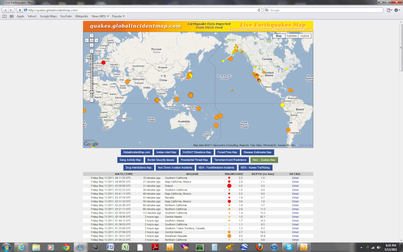
    4.5 in Poland.


    The Earthquake/Seismic Activity Log - Page 9 Untitl39
    HigherLove
    HigherLove


    Posts : 2357
    Join date : 2011-01-27
    Age : 59

    The Earthquake/Seismic Activity Log - Page 9 Empty Re: The Earthquake/Seismic Activity Log

    Post  HigherLove Fri May 13, 2011 6:19 pm

    Magnitude
    6.0

    Date-Time
    Friday, May 13, 2011 at 22:47:55 UTC
    Friday, May 13, 2011 at 04:47:55 PM at epicenter
    Location
    10.105°N, 84.261°W
    Depth
    70 km (43.5 miles)
    Region
    COSTA RICA
    Distances
    28 km (17 miles) NW of SAN JOSE, Costa Rica
    64 km (39 miles) ENE of Puntarenas, Costa Rica
    125 km (77 miles) SSE of San Carlos, Nicaragua
    135 km (83 miles) W of Limon, Costa Rica
    Location Uncertainty
    horizontal +/- 16.5 km (10.3 miles); depth +/- 8.8 km (5.5 miles)
    Parameters
    NST=376, Nph=381, Dmin=20 km, Rmss=1.23 sec, Gp=115°,
    M-type=regional moment magnitude (Mw), Version=9
    Source
    USGS NEIC (WDCS-D)
    Event ID
    usc0003et0
    HigherLove
    HigherLove


    Posts : 2357
    Join date : 2011-01-27
    Age : 59

    The Earthquake/Seismic Activity Log - Page 9 Empty Re: The Earthquake/Seismic Activity Log

    Post  HigherLove Fri May 13, 2011 6:23 pm

    2.0 Mt. Hood, Oregon
    HigherLove
    HigherLove


    Posts : 2357
    Join date : 2011-01-27
    Age : 59

    The Earthquake/Seismic Activity Log - Page 9 Empty Re: The Earthquake/Seismic Activity Log

    Post  HigherLove Fri May 13, 2011 6:26 pm

    MAP 6.0 2011/05/13 22:47:55 10.105 -84.261 70.0 COSTA RICA
    MAP 4.8 2011/05/13 22:18:08 -58.998 -25.536 79.2 SOUTH SANDWICH ISLANDS REGION
    MAP 4.8 2011/05/13 21:49:26 35.904 141.044 16.4 NEAR THE EAST COAST OF HONSHU, JAPAN
    MAP 5.2 2011/05/13 21:43:21 -9.990 107.647 12.5 SOUTH OF JAVA, INDONESIA
    MAP 4.9 2011/05/13 21:39:30 36.579 70.931 238.1 HINDU KUSH REGION, AFGHANISTAN
    MAP 4.3 2011/05/13 20:30:43 60.045 -152.613 101.4 SOUTHERN ALASKA
    MAP 4.5 2011/05/13 20:17:40 38.053 141.212 41.3 NEAR THE EAST COAST OF HONSHU, JAPAN
    MAP 4.0 2011/05/13 20:09:29 53.889 -161.319 1.0 SOUTH OF ALASKA
    MAP 4.7 2011/05/13 19:32:54 -6.829 154.837 59.2 BOUGAINVILLE REGION, PAPUA NEW GUINEA
    MAP 2.9 2011/05/13 18:23:32 52.676 -170.000 44.2 FOX ISLANDS, ALEUTIAN ISLANDS, ALASKA
    MAP 2.9 2011/05/13 17:53:26 19.692 -157.516 10.0 HAWAIIAN ISLANDS REGION
    MAP 2.8 2011/05/13 17:14:32 35.264 -92.358 3.6 ARKANSAS
    MAP 4.8 2011/05/13 17:05:06 -20.985 -176.647 215.4 FIJI REGION
    MAP 5.1 2011/05/13 15:55:50 -11.511 165.440 49.5 SANTA CRUZ ISLANDS
    MAP 4.9 2011/05/13 15:18:26 6.776 -73.012 165.9 NORTHERN COLOMBIA
    MAP 2.7 2011/05/13 13:47:20 38.412 -118.719 4.2 NEVADA
    MAP 2.5 2011/05/13 13:38:45 53.624 -177.277 3.4 ANDREANOF ISLANDS, ALEUTIAN IS., ALASKA
    MAP 3.6 2011/05/13 12:47:37 18.862 -64.466 58.2 VIRGIN ISLANDS REGION
    MAP 4.3 2011/05/13 12:19:17 35.185 140.860 53.6 NEAR THE EAST COAST OF HONSHU, JAPAN
    MAP 4.6 2011/05/13 10:17:01 37.685 143.590 30.6 OFF THE EAST COAST OF HONSHU, JAPAN
    MAP 3.2 2011/05/13 09:56:52 34.832 -116.378 4.0 SOUTHERN CALIFORNIA
    MAP 4.5 2011/05/13 07:43:18 -6.899 147.820 66.4 EASTERN NEW GUINEA REG, PAPUA NEW GUINEA
    MAP 4.8 2011/05/13 06:48:15 41.935 82.360 26.9 SOUTHERN XINJIANG, CHINA
    MAP 4.9 2011/05/13 06:46:09 12.257 144.106 22.9 GUAM REGION
    MAP 4.7 2011/05/13 05:11:57 0.043 124.213 98.6 MINAHASA, SULAWESI, INDONESIA
    MAP 3.1 2011/05/13 04:38:08 35.349 -118.564 6.4 CENTRAL CALIFORNIA
    MAP 2.8 2011/05/13 04:09:06 32.637 -115.806 1.1 BAJA CALIFORNIA, MEXICO
    MAP 4.5 2011/05/13 03:59:08 51.374 16.152 5.0 POLAND
    MAP 4.9 2011/05/13 03:36:51 -59.428 -151.236 10.0 PACIFIC-ANTARCTIC RIDGE
    MAP 3.6 2011/05/13 03:31:33 32.657 -115.790 13.5 SOUTHERN CALIFORNIA
    MAP 2.7 2011/05/13 01:27:09 63.617 -147.923 14.3 CENTRAL ALASKA
    MAP 4.0 2011/05/13 01:19:21 19.536 -70.423 35.8 DOMINICAN REPUBLIC
    MAP 5.5 2011/05/13 01:04:39 12.450 143.996 17.9 GUAM REGION
    MAP 5.1 2011/05/13 00:25:45 12.333 144.222 9.9 GUAM REGION
    MAP 4.9 2011/05/13 00:20:38 12.565 143.936 35.9 GUAM REGION


    Last edited by HigherLove on Fri May 13, 2011 6:29 pm; edited 1 time in total

      Current date/time is Mon Nov 18, 2024 10:31 pm