tMoA

Would you like to react to this message? Create an account in a few clicks or log in to continue.
tMoA

~ The only Home on the Web You'll ever need ~

+21
Aquaries1111
giovonni
arvan33
Floyd
lawlessline
JesterTerrestrial
THEeXchanger
newel
Brook
greybeard
Mercuriel
Sanicle
devakas
hobbit
mudra
burgundia
lindabaker
LeeEllisMusic
MargueriteBee
Carol
HigherLove
25 posters

    The Earthquake/Seismic Activity Log

    HigherLove
    HigherLove


    Posts : 2357
    Join date : 2011-01-27
    Age : 59

    The Earthquake/Seismic Activity Log - Page 7 Empty Re: The Earthquake/Seismic Activity Log

    Post  HigherLove Mon Apr 25, 2011 8:58 pm

    Downgraded to a 4.9 from preliminary of 5.1 -

    Magnitude
    4.9
    Date-Time
    Tuesday, April 26, 2011 at 01:28:36 UTC
    Monday, April 25, 2011 at 04:28:36 PM at epicenter
    Time of Earthquake in other Time Zones
    Location
    51.313°N, 179.157°E
    Depth
    41.2 km (25.6 miles)
    Region
    RAT ISLANDS, ALEUTIAN ISLANDS, ALASKA
    Distances
    74 km (45 miles) SSW of Semisopochnoi Island, Alaska
    83 km (51 miles) SSE of Little Sitkin Island, Alaska
    2969 km (1844 miles) W of WHITEHORSE, Yukon Territory, Canada
    3570 km (2218 miles) NE of TOKYO, Japan
    Location Uncertainty
    horizontal +/- 20.4 km (12.7 miles); depth +/- 8.3 km (5.2 miles)
    Parameters
    NST=242, Nph=270, Dmin=342.9 km, Rmss=1.3 sec, Gp=137°,
    M-type=body wave magnitude (Mb), Version=A
    Source
    USGS NEIC (WDCS-D)
    Event ID
    usc0002ywl
    HigherLove
    HigherLove


    Posts : 2357
    Join date : 2011-01-27
    Age : 59

    The Earthquake/Seismic Activity Log - Page 7 Empty Re: The Earthquake/Seismic Activity Log

    Post  HigherLove Mon Apr 25, 2011 9:00 pm

    <iframe title="YouTube video player" width="480" height="390" src="https://www.youtube.com/embed/qQ9Mw_rtDng" frameborder="0" allowfullscreen></iframe>
    HigherLove
    HigherLove


    Posts : 2357
    Join date : 2011-01-27
    Age : 59

    The Earthquake/Seismic Activity Log - Page 7 Empty Re: The Earthquake/Seismic Activity Log

    Post  HigherLove Mon Apr 25, 2011 10:35 pm

    Magnitude
    4.6
    Date-Time
    Tuesday, April 26, 2011 at 03:16:24 UTC
    Tuesday, April 26, 2011 at 11:16:24 AM at epicenter
    Location
    20.518°N, 119.932°E
    Depth
    15.6 km (9.7 miles)
    Region
    PHILIPPINE ISLANDS REGION
    Distances
    216 km (134 miles) W (273°) from Basco, Batan Islands, Philippines
    234 km (146 miles) S (189°) from Kao-hsiung, Taiwan
    264 km (164 miles) NNW (345°) from Laoag, Luzon, Philippines
    665 km (413 miles) N (351°) from MANILA, Philippines
    Location Uncertainty
    horizontal +/- 15.3 km (9.5 miles); depth +/- 6.6 km (4.1 miles)
    Parameters
    NST= 61, Nph= 68, Dmin=280.5 km, Rmss=0.92 sec, Gp= 61°,
    M-type=body wave magnitude (Mb), Version=6
    Source
    U.S. Geological Survey, National Earthquake Information Center:
    World Data Center for Seismology, Denver
    Event ID
    usc0002yz2


    HigherLove
    HigherLove


    Posts : 2357
    Join date : 2011-01-27
    Age : 59

    The Earthquake/Seismic Activity Log - Page 7 Empty Re: The Earthquake/Seismic Activity Log

    Post  HigherLove Tue Apr 26, 2011 5:10 am


    Magnitude 3.1
    Date-Time

    Tuesday, April 26, 2011 at 08:02:49 UTC
    Tuesday, April 26, 2011 at 01:02:49 AM at epicenter
    Time of Earthquake in other Time Zones

    Location 40.226°N, 121.062°W
    Depth 0 km (~0 mile) (poorly constrained)
    Region NORTHERN CALIFORNIA
    Distances

    2 km (1 miles) SE (146°) from East Shore, CA
    6 km (4 miles) N (10°) from Canyondam, CA
    6 km (4 miles) SSE (152°) from Hamilton Branch, CA
    41 km (26 miles) WSW (239°) from Susanville, CA
    189 km (117 miles) N (11°) from Sacramento, CA

    Location Uncertainty horizontal +/- 0.5 km (0.3 miles); depth +/- 1.5 km (0.9 miles)
    Parameters Nph= 48, Dmin=25 km, Rmss=0.26 sec, Gp= 86°,
    M-type=local magnitude (ML), Version=2
    Source

    California Integrated Seismic Net:
    USGS Caltech CGS UCB UCSD UNR

    Event ID nc71565781
    _________________________________

    MAP 3.1 2011/04/26 08:02:50 40.226 -121.062 0.0 NORTHERN CALIFORNIA
    MAP 3.4 2011/04/26 07:25:43 19.136 -64.595 48.4 VIRGIN ISLANDS REGION
    MAP 5.4 2011/04/26 06:39:35 -8.034 108.492 78.6 JAVA, INDONESIA
    MAP 2.9 2011/04/26 04:49:54 18.229 -66.958 24.0 PUERTO RICO
    MAP 2.8 2011/04/26 04:17:01 18.487 -67.388 14.9 MONA PASSAGE, PUERTO RICO
    HigherLove
    HigherLove


    Posts : 2357
    Join date : 2011-01-27
    Age : 59

    The Earthquake/Seismic Activity Log - Page 7 Empty Re: The Earthquake/Seismic Activity Log

    Post  HigherLove Tue Apr 26, 2011 6:51 am

    Magnitude 5.7
    Date-Time

    Tuesday, April 26, 2011 at 11:07:29 UTC
    Tuesday, April 26, 2011 at 06:07:29 AM at epicenter
    Time of Earthquake in other Time Zones

    Location 17.002°N, 99.454°W
    Depth 20.6 km (12.8 miles)
    Region GUERRERO, MEXICO
    Distances 48 km (29 miles) ENE of Acapulco, Guerrero, Mexico
    61 km (37 miles) S of Chilpancingo, Guerrero, Mexico
    149 km (92 miles) S of Iguala, Guerrero, Mexico
    269 km (167 miles) S of MEXICO CITY, D.F., Mexico
    Location Uncertainty horizontal +/- 13.6 km (8.5 miles); depth +/- 6.6 km (4.1 miles)
    Parameters NST=289, Nph=324, Dmin=113.5 km, Rmss=0.86 sec, Gp=104°,
    M-type=regional moment magnitude (Mw), Version=A
    Source

    USGS NEIC (WDCS-D)

    Event ID usc0002z6v


    ________________________________

    Magnitude 4.6
    Date-Time

    Tuesday, April 26, 2011 at 11:18:35 UTC
    Tuesday, April 26, 2011 at 06:18:35 AM at epicenter
    Time of Earthquake in other Time Zones

    Location 16.862°N, 99.507°W
    Depth 29 km (18.0 miles)
    Region GUERRERO, MEXICO
    Distances 39 km (24 miles) E of Acapulco, Guerrero, Mexico
    76 km (47 miles) S of Chilpancingo, Guerrero, Mexico
    165 km (102 miles) S of Iguala, Guerrero, Mexico
    285 km (177 miles) S of MEXICO CITY, D.F., Mexico
    Location Uncertainty horizontal +/- 27.6 km (17.1 miles); depth +/- 8.3 km (5.2 miles)
    Parameters NST= 85, Nph= 92, Dmin=126.9 km, Rmss=1.19 sec, Gp=209°,
    M-type=body wave magnitude (Mb), Version=8
    Source

    USGS NEIC (WDCS-D)

    Event ID usc0002z77


    The Earthquake/Seismic Activity Log - Page 7 Unled1111
    HigherLove
    HigherLove


    Posts : 2357
    Join date : 2011-01-27
    Age : 59

    The Earthquake/Seismic Activity Log - Page 7 Empty Re: The Earthquake/Seismic Activity Log

    Post  HigherLove Tue Apr 26, 2011 8:02 am

    Magnitude 4.7
    Date-Time

    Tuesday, April 26, 2011 at 12:14:18 UTC
    Tuesday, April 26, 2011 at 09:14:18 AM at epicenter
    Time of Earthquake in other Time Zones

    Location 23.933°S, 66.296°W
    Depth 182.1 km (113.2 miles)
    Region SALTA, ARGENTINA
    Distances 32 km (19 miles) N of San Antonio de los Cobres, Salta, Arg.
    105 km (65 miles) WNW of San Salvador de Jujuy, Jujuy, Argentina
    130 km (80 miles) NW of Salta, Salta, Argentina
    1394 km (866 miles) NW of BUENOS AIRES, D.F., Argentina
    Location Uncertainty horizontal +/- 32.9 km (20.4 miles); depth +/- 6.4 km (4.0 miles)
    Parameters NST= 49, Nph= 49, Dmin=433 km, Rmss=0.78 sec, Gp=148°,
    M-type=body wave magnitude (Mb), Version=5
    Source

    USGS NEIC (WDCS-D)

    Event ID usc0002z7x

    The Earthquake/Seismic Activity Log - Page 7 Unled2222
    HigherLove
    HigherLove


    Posts : 2357
    Join date : 2011-01-27
    Age : 59

    The Earthquake/Seismic Activity Log - Page 7 Empty Re: The Earthquake/Seismic Activity Log

    Post  HigherLove Tue Apr 26, 2011 12:48 pm

    This is a significant event for the geysers (capable of toppling chimneys). Also, lots of quakes around the globe. Posting in a moment.

    Magnitude
    3.5

    Date-Time
    Tuesday, April 26, 2011 at 17:43:08 UTC
    Tuesday, April 26, 2011 at 10:43:08 AM at epicenter
    Location
    38.813°N, 122.817°W
    Depth
    3.2 km (2.0 miles)
    Region

    NORTHERN CALIFORNIA
    Distances

    2 km (1 miles) NNW (330°) from The Geysers, CA
    9 km (5 miles) WSW (253°) from Cobb, CA
    12 km (7 miles) WNW (291°) from Anderson Springs, CA
    42 km (26 miles) NNW (346°) from Santa Rosa, CA
    120 km (75 miles) WNW (284°) from Sacramento, CA

    Location Uncertainty
    horizontal +/- 0.1 km (0.1 miles); depth +/- 0.2 km (0.1 miles)
    Parameters
    Nph= 67, Dmin=1 km, Rmss=0.05 sec, Gp= 29°,
    M-type=local magnitude (ML), Version=2
    Source
    California Integrated Seismic Net:
    USGSCaltechCGSUCBUCSDUNR
    Event ID
    nc71566046
    HigherLove
    HigherLove


    Posts : 2357
    Join date : 2011-01-27
    Age : 59

    The Earthquake/Seismic Activity Log - Page 7 Empty Re: The Earthquake/Seismic Activity Log

    Post  HigherLove Tue Apr 26, 2011 12:53 pm

    Even larger...

    Magnitude
    3.9

    Date-Time
    Tuesday, April 26, 2011 at 17:43:08 UTC
    Tuesday, April 26, 2011 at 10:43:08 AM at epicenter
    Location
    38.813°N, 122.817°W
    Depth
    3.2 km (2.0 miles)
    Region
    NORTHERN CALIFORNIA
    Distances

    2 km (1 miles) NNW (330°) from The Geysers, CA
    9 km (5 miles) WSW (253°) from Cobb, CA
    12 km (7 miles) WNW (291°) from Anderson Springs, CA
    42 km (26 miles) NNW (346°) from Santa Rosa, CA
    120 km (75 miles) WNW (284°) from Sacramento, CA

    Location Uncertainty
    horizontal +/- 0.1 km (0.1 miles); depth +/- 0.2 km (0.1 miles)
    Parameters
    Nph= 67, Dmin=1 km, Rmss=0.05 sec, Gp= 29°,
    M-type=regional moment magnitude (Mw), Version=3
    Source
    California Integrated Seismic Net:
    USGSCaltechCGSUCBUCSDUNR
    Event ID
    nc71566046

    ______________

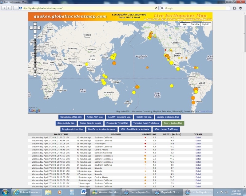
    Tuesday April 26 2011, 17:43:08 UTC 10 minutes ago Northern California 3.9 3.2 Detail
    Tuesday April 26 2011, 17:30:35 UTC 22 minutes ago Central California 1.2 3.9 Detail
    Tuesday April 26 2011, 17:07:26 UTC 45 minutes ago Central California 1.3 4.3 Detail
    Tuesday April 26 2011, 17:00:35 UTC 52 minutes ago Assam-Nagaland-Manipur region, India 4.3 52.5 Detail
    Tuesday April 26 2011, 16:50:18 UTC 62 minutes ago Las Vegas urban area, Nevada 1.8 0.0 Detail
    Tuesday April 26 2011, 16:43:57 UTC 69 minutes ago Central Alaska 1.5 92.0 Detail
    Tuesday April 26 2011, 16:41:59 UTC 71 minutes ago Central California 2.3 5.8 Detail
    Tuesday April 26 2011, 16:16:43 UTC 96 minutes ago Central California 3.2 3.9 Detail
    Tuesday April 26 2011, 16:09:41 UTC 103 minutes ago Southern California 1.6 5.0 Detail
    Tuesday April 26 2011, 16:02:07 UTC 111 minutes ago off the east coast of Honshu, Japan 4.6 35.0 Detail
    Tuesday April 26 2011, 15:58:57 UTC 114 minutes ago off the east coast of Honshu, Japan 4.6 10.0 Detail
    Tuesday April 26 2011, 15:52:20 UTC 2 hours ago Mindanao, Philippines 4.1 381.5 Detail
    Tuesday April 26 2011, 15:20:47 UTC 2 hours ago Southern Alaska 1.5 1.5 Detail
    Tuesday April 26 2011, 15:16:41 UTC 2 hours ago Northern California 1.1 1.8 Detail
    Tuesday April 26 2011, 15:07:01 UTC 2 hours ago Southern Alaska 1.4 29.8 Detail
    Tuesday April 26 2011, 15:05:51 UTC 2 hours ago Central Alaska 1.9 1.5 Detail
    Tuesday April 26 2011, 15:00:05 UTC 2 hours ago Northern California 2.1 3.0 Detail
    Tuesday April 26 2011, 14:47:37 UTC 3 hours ago San Francisco Bay area, California 2.3 3.3 Detail
    Tuesday April 26 2011, 14:29:35 UTC 3 hours ago Central Alaska 1.7 13.5 Detail
    Tuesday April 26 2011, 14:12:32 UTC 3 hours ago Island of Hawaii, Hawaii 2.2 7.7 Detail
    Tuesday April 26 2011, 14:10:28 UTC 3 hours ago Southern Yukon Territory, Canada 2.0 0.0 Detail
    Tuesday April 26 2011, 14:08:02 UTC 3 hours ago Southern Alaska 1.5 28.0 Detail
    Tuesday April 26 2011, 13:49:01 UTC 4 hours ago Southern Alaska 2.7 141.1 Detail
    Tuesday April 26 2011, 13:49:01 UTC 4 hours ago Southern Alaska 2.7 141.1 Detail
    Tuesday April 26 2011, 13:06:01 UTC 4 hours ago Oklahoma 2.5 5.0 Detail
    Tuesday April 26 2011, 13:04:21 UTC 4 hours ago Southern Alaska 2.0 98.8 Detail
    Tuesday April 26 2011, 12:48:49 UTC 5 hours ago Southern California 1.7 9.6 Detail
    Tuesday April 26 2011, 12:46:08 UTC 5 hours ago Gulf of Alaska 2.9 9.7 Detail
    Tuesday April 26 2011, 12:46:08 UTC 5 hours ago Gulf of Alaska 2.9 9.7 Detail
    Tuesday April 26 2011, 12:26:54 UTC 5 hours ago near the east coast of Honshu, Japan 4.6 54.6 Detail
    Tuesday April 26 2011, 12:20:52 UTC 5 hours ago Southern California 1.8 6.0 Detail
    Tuesday April 26 2011, 12:14:18 UTC 5 hours ago Salta, Argentina 4.7 182.1 Detail
    Tuesday April 26 2011, 12:12:00 UTC 5 hours ago near the east coast of Honshu, Japan 5.0 51.7 Detail
    Tuesday April 26 2011, 12:10:05 UTC 5 hours ago Nevada 2.6 0.0 Detail
    Tuesday April 26 2011, 11:57:05 UTC 5 hours ago offshore Baja California, Mexico 2.9 21.0 Detail
    Tuesday April 26 2011, 11:24:58 UTC 6 hours ago Southern Alaska 2.0 18.9 Detail
    Tuesday April 26 2011, 11:18:35 UTC 6 hours ago Guerrero, Mexico 4.6 29.0 Detail
    Tuesday April 26 2011, 11:07:30 UTC 6 hours ago Guerrero, Mexico 5.3 19.5 Detail
    HigherLove
    HigherLove


    Posts : 2357
    Join date : 2011-01-27
    Age : 59

    The Earthquake/Seismic Activity Log - Page 7 Empty Re: The Earthquake/Seismic Activity Log

    Post  HigherLove Tue Apr 26, 2011 1:03 pm

    The Earthquake/Seismic Activity Log - Page 7 Untitl18
    HigherLove
    HigherLove


    Posts : 2357
    Join date : 2011-01-27
    Age : 59

    The Earthquake/Seismic Activity Log - Page 7 Empty Re: The Earthquake/Seismic Activity Log

    Post  HigherLove Tue Apr 26, 2011 4:56 pm

    Magnitude
    5.6

    Date-Time
    Tuesday, April 26, 2011 at 21:10:26 UTC
    Tuesday, April 26, 2011 at 02:10:26 PM at epicenter
    Time of Earthquake in other Time Zones
    Location
    27.439°N, 111.598°W
    Depth
    15.1 km (9.4 miles)
    Region
    GULF OF CALIFORNIA
    Distances
    73 km (45 miles) E of Santa Rosalia, Baja Calif. Sur, Mexico
    88 km (54 miles) SW of Guaymas, Sonora, Mexico
    161 km (100 miles) N of Loreto, Baja California Sur, Mexico
    667 km (414 miles) S of PHOENIX, Arizona
    Location Uncertainty
    horizontal +/- 20 km (12.4 miles); depth +/- 8.2 km (5.1 miles)
    Parameters
    NST=136, Nph=137, Dmin=64.6 km, Rmss=1.19 sec, Gp=101°,
    M-type=regional moment magnitude (Mw), Version=8
    Source
    USGS NEIC (WDCS-D)
    Event ID
    usc0002zkq


    MAP 2.6 2011/04/26 21:36:35 62.405 -150.349 49.1 CENTRAL ALASKA
    MAP 5.6 2011/04/26 21:10:26 27.439 -111.598 15.1 GULF OF CALIFORNIA
    MAP 2.6 2011/04/26 19:09:22 35.893 -117.643 8.4 CENTRAL CALIFORNIA
    MAP 4.7 2011/04/26 19:01:42 -24.914 179.770 515.1 SOUTH OF THE FIJI ISLANDS
    MAP 2.6 2011/04/26 18:55:26 35.952 -117.661 5.6 CENTRAL CALIFORNIA
    MAP 4.6 2011/04/26 18:39:27 2.338 128.756 47.5 HALMAHERA, INDONESIA
    MAP 4.8 2011/04/26 18:03:29 36.588 143.255 37.5 OFF THE EAST COAST OF HONSHU, JAPAN
    MAP 3.9 2011/04/26 17:43:08 38.813 -122.817 3.2 NORTHERN CALIFORNIA
    MAP 4.3 2011/04/26 17:00:36 25.247 93.206 52.5 ASSAM-NAGALAND-MANIPUR REGION, INDIA
    MAP 4.6 2011/04/26 16:45:39 -15.624 -172.581 35.6 SAMOA ISLANDS REGION
    MAP 3.2 2011/04/26 16:16:44 35.970 -117.648 3.9 CENTRAL CALIFORNIA
    MAP 4.6 2011/04/26 16:02:08 34.656 142.738 35.0 OFF THE EAST COAST OF HONSHU, JAPAN
    MAP 4.6 2011/04/26 15:58:57 39.707 145.074 10.0 OFF THE EAST COAST OF HONSHU, JAPAN
    MAP 4.1 2011/04/26 15:52:20 5.398 124.684 381.5 MINDANAO, PHILIPPINES
    MAP 2.7 2011/04/26 13:49:01 59.912 -153.499 141.1 SOUTHERN ALASKA
    MAP 2.5 2011/04/26 13:06:02 34.845 -97.498 5.0 OKLAHOMA
    MAP 2.9 2011/04/26 12:46:08 58.544 -150.744 9.7 GULF OF ALASKA
    MAP 4.6 2011/04/26 12:26:55 38.370 141.807 54.6 NEAR THE EAST COAST OF HONSHU, JAPAN
    MAP 4.7 2011/04/26 12:14:18 -23.933 -66.296 182.1 SALTA, ARGENTINA
    MAP 5.0 2011/04/26 12:12:01 36.124 140.068 51.7 NEAR THE EAST COAST OF HONSHU, JAPAN
    MAP 2.6 2011/04/26 12:10:05 38.422 -118.718 0.0 NEVADA
    MAP 2.9 2011/04/26 11:57:06 31.962 -117.248 21.0 OFFSHORE BAJA CALIFORNIA, MEXICO
    MAP 4.6 2011/04/26 11:18:36 16.862 -99.507 29.0 GUERRERO, MEXICO
    MAP 5.3 2011/04/26 11:07:31 17.100 -99.380 19.5 GUERRERO, MEXICO
    MAP 4.6 2011/04/26 10:16:48 -4.350 122.897 13.6 SULAWESI, INDONESIA
    MAP 4.9 2011/04/26 10:03:05 37.689 143.935 20.4 OFF THE EAST COAST OF HONSHU, JAPAN
    MAP 2.9 2011/04/26 08:31:56 19.122 -64.477 62.2 VIRGIN ISLANDS REGION
    MAP 3.3 2011/04/26 08:02:50 40.230 -121.053 2.0 NORTHERN CALIFORNIA
    MAP 3.4 2011/04/26 07:25:43 19.136 -64.595 48.4 VIRGIN ISLANDS REGION
    MAP 4.9 2011/04/26 07:24:56 -8.141 108.394 64.6 JAVA, INDONESIA
    MAP 5.4 2011/04/26 06:39:35 -8.034 108.492 78.6 JAVA, INDONESIA
    MAP 2.9 2011/04/26 04:49:54 18.229 -66.958 24.0 PUERTO RICO
    MAP 2.8 2011/04/26 04:17:01 18.487 -67.388 14.9 MONA PASSAGE, PUERTO RICO
    MAP 4.9 2011/04/26 04:01:52 37.288 141.357 34.9 NEAR THE EAST COAST OF HONSHU, JAPAN
    MAP 4.6 2011/04/26 03:16:25 20.518 119.932 15.6 PHILIPPINE ISLANDS REGION
    MAP 4.9 2011/04/26 01:28:37 51.313 179.157 41.2 RAT ISLANDS, ALEUTIAN ISLANDS, ALASKA
    MAP 2.8 2011/04/26 00:51:24 32.629 -115.800 10.5 BAJA CALIFORNIA, MEXICO
    MAP 5.2 2011/04/26 00:12:17 -17.354 -174.441 62.8 TONGA
    HigherLove
    HigherLove


    Posts : 2357
    Join date : 2011-01-27
    Age : 59

    The Earthquake/Seismic Activity Log - Page 7 Empty Re: The Earthquake/Seismic Activity Log

    Post  HigherLove Tue Apr 26, 2011 4:58 pm

    The Earthquake/Seismic Activity Log - Page 7 Untitl19
    HigherLove
    HigherLove


    Posts : 2357
    Join date : 2011-01-27
    Age : 59

    The Earthquake/Seismic Activity Log - Page 7 Empty Re: The Earthquake/Seismic Activity Log

    Post  HigherLove Tue Apr 26, 2011 5:01 pm

    Magnitude
    5.6

    Date-Time
    Tuesday, April 26, 2011 at 21:43:45 UTC
    Wednesday, April 27, 2011 at 05:43:45 AM at epicenter
    Location
    8.988°S, 125.613°E
    Depth
    1.1 km (~0.7 mile) (poorly constrained)
    Region
    EAST TIMOR REGION
    Distances
    45 km (28 miles) S (176°) from DILI, East Timor
    258 km (160 miles) ENE (60°) from Kupang, Timor, Indonesia
    434 km (270 miles) E (92°) from Ende, Flores, Indonesia
    Location Uncertainty
    horizontal +/- 16.3 km (10.1 miles); depth +/- 8 km (5.0 miles)
    Parameters
    NST= 48, Nph= 51, Dmin=170.3 km, Rmss=0.91 sec, Gp= 58°,
    M-type=regional moment magnitude (Mw), Version=7
    Source
    U.S. Geological Survey, National Earthquake Information Center:
    World Data Center for Seismology, Denver
    Event ID
    usc0002zlj

    The Earthquake/Seismic Activity Log - Page 7 Untitl20
    HigherLove
    HigherLove


    Posts : 2357
    Join date : 2011-01-27
    Age : 59

    The Earthquake/Seismic Activity Log - Page 7 Empty Re: The Earthquake/Seismic Activity Log

    Post  HigherLove Wed Apr 27, 2011 12:22 am

    Magnitude 5.3
    Date-Time

    Wednesday, April 27, 2011 at 04:57:33 UTC
    Wednesday, April 27, 2011 at 12:57:33 AM at epicenter

    Location 33.853°S, 72.167°W
    Depth 7.1 km (4.4 miles) (poorly constrained)
    Region OFFSHORE VALPARAISO, CHILE
    Distances

    97 km (60 miles) SSW (208°) from Valparaiso, Chile
    144 km (90 miles) WSW (254°) from SANTIAGO, Chile
    185 km (115 miles) NNW (346°) from Talca, Chile

    Location Uncertainty horizontal +/- 22.2 km (13.8 miles); depth +/- 7.1 km (4.4 miles)
    Parameters NST=178, Nph=179, Dmin=144.7 km, Rmss=0.74 sec, Gp=130°,
    M-type=body wave magnitude (Mb), Version=6
    Source

    U.S. Geological Survey, National Earthquake Information Center:
    World Data Center for Seismology, Denver

    Event ID usc0002ztt
    HigherLove
    HigherLove


    Posts : 2357
    Join date : 2011-01-27
    Age : 59

    The Earthquake/Seismic Activity Log - Page 7 Empty Re: The Earthquake/Seismic Activity Log

    Post  HigherLove Wed Apr 27, 2011 12:39 pm

    Relatively quiet since last night...

    Eastern Tennessee just had a 2.1

    MAP 2.1 2011/04/27 16:29:18 35.219 -84.386 11.8 18 km ( 11 mi) SE of Etowah, TN
    MAP 2.5 2011/04/24 10:09:16 35.578 -85.000 18.4 10 km ( 6 mi) N of Dayton, TN
    ___________________________________________

    MAP 4.3 2011/04/27 16:14:00 -20.387 -68.588 106.5 POTOSI, BOLIVIA
    MAP 4.9 2011/04/27 16:03:30 26.685 143.680 10.0 BONIN ISLANDS, JAPAN REGION
    MAP 4.7 2011/04/27 14:34:04 -15.583 -174.796 18.2 TONGA
    MAP 3.5 2011/04/27 13:23:36 38.409 -118.726 0.7 NEVADA
    MAP 4.8 2011/04/27 11:21:14 -19.683 -66.221 30.6 POTOSI, BOLIVIA
    MAP 3.4 2011/04/27 07:45:32 60.844 -149.279 17.9 KENAI PENINSULA, ALASKA
    MAP 4.7 2011/04/27 06:56:18 -40.387 -71.518 45.4 NEUQUEN, ARGENTINA
    MAP 5.3 2011/04/27 04:57:34 -33.853 -72.167 7.1 OFFSHORE VALPARAISO, CHILE
    MAP 2.6 2011/04/27 04:12:30 32.529 -115.697 0.1 BAJA CALIFORNIA, MEXICO
    MAP 2.7 2011/04/27 03:52:36 35.736 -118.036 9.7 CENTRAL CALIFORNIA
    MAP 3.4 2011/04/27 03:42:48 19.181 -67.891 69.7 DOMINICAN REPUBLIC REGION
    MAP 2.5 2011/04/27 02:24:33 62.467 -149.649 50.2 CENTRAL ALASKA


    The Earthquake/Seismic Activity Log - Page 7 Untitl21
    HigherLove
    HigherLove


    Posts : 2357
    Join date : 2011-01-27
    Age : 59

    The Earthquake/Seismic Activity Log - Page 7 Empty Re: The Earthquake/Seismic Activity Log

    Post  HigherLove Wed Apr 27, 2011 2:35 pm

    Magnitude
    4.0

    Date-Time
    Wednesday, April 27, 2011 at 19:19:20 UTC
    Wednesday, April 27, 2011 at 12:19:20 PM at epicenter
    Location
    38.417°N, 118.707°W
    Depth
    5.1 km (3.2 miles)
    Region
    NEVADA
    Distances
    14 km (9 miles) SSW (211°) from Hawthorne, NV
    20 km (12 miles) NW (308°) from Qualeys Camp, NV
    29 km (18 miles) SE (124°) from Wichman, NV
    241 km (150 miles) E (93°) from Sacramento, CA
    Location Uncertainty
    horizontal +/- 0.3 km (0.2 miles); depth +/- 0.5 km (0.3 miles)
    Parameters
    NST= 62, Nph= 23, Dmin=7 km, Rmss=0.12 sec, Gp= 58°,
    M-type=local magnitude (ML), Version=7
    Source
    Seismological Laboratory, University of Nevada, Reno
    Event ID
    nn00335238

    MAP 4.0 2011/04/27 19:19:20 38.417 -118.707 5.1 14 km ( 9 mi) SSW of Hawthorne, NV
    MAP 3.5 2011/04/27 13:23:35 38.409 -118.726 0.7 16 km ( 10 mi) SW of Hawthorne, NV
    MAP 3.4 2011/04/27 07:45:32 60.844 -149.279 17.9 9 km ( 6 mi) ESE of Sunrise, AK
    MAP 3.4 2011/04/27 03:42:47 19.181 -67.891 69.7 106 km ( 66 mi) NE of Hig�ey, Dominican Republic
    MAP 5.6 2011/04/26 21:10:26 27.439 -111.598 15.1 69 km ( 43 mi) E of Santa Rosal�a, Mexico
    MAP 3.9 2011/04/26 17:43:08 38.813 -122.817 3.5 2 km ( 1 mi) NNW of The Geysers, CA
    MAP 3.2 2011/04/26 16:16:43 35.970 -117.648 3.9 28 km ( 18 mi) ESE of Coso Junction, CA
    MAP 3.3 2011/04/26 08:02:49 40.230 -121.053 2.0 2 km ( 2 mi) ESE of East Shore, CA
    MAP 3.4 2011/04/26 07:25:42 19.136 -64.595 48.4 54 km ( 33 mi) NNW of Settlement, British Virgin Islands
    MAP 4.9 2011/04/26 01:28:36 51.313 -180.843 41.2 297 km (184 mi) W of Adak, AK
    HigherLove
    HigherLove


    Posts : 2357
    Join date : 2011-01-27
    Age : 59

    The Earthquake/Seismic Activity Log - Page 7 Empty Re: The Earthquake/Seismic Activity Log

    Post  HigherLove Wed Apr 27, 2011 5:08 pm

    St. Helens --

    Magnitude
    2.0
    Date-Time
    Wednesday, April 27, 2011 at 21:37:05 UTC
    Wednesday, April 27, 2011 at 02:37:05 PM at epicenter
    Time of Earthquake in other Time Zones
    Location
    46.068°N, 122.359°W
    Depth
    10.6 km (6.6 miles) set by location program
    Region
    WASHINGTON
    Distances
    20 km (12 miles) NNE (24°) from Amboy, WA
    20 km (12 miles) SW (223°) from Mount St. Helens Volcano, WA
    23 km (14 miles) N (9°) from Yacolt, WA
    47 km (29 miles) E (100°) from Longview, WA
    52 km (32 miles) NNE (21°) from Vancouver, WA
    Location Uncertainty
    horizontal +/- 0.6 km (0.4 miles); depth fixed by location program
    Parameters
    NST= 10, Nph= 10, Dmin=3 km, Rmss=0.1 sec, Gp=151°,
    M-type=duration magnitude (Md), Version=0
    Source
    Pacific Northwest Seismograph Network
    Event ID
    uw04272137

    _____________________________

    The whole globe is humming right now...

    The Earthquake/Seismic Activity Log - Page 7 Untitl22

    HigherLove
    HigherLove


    Posts : 2357
    Join date : 2011-01-27
    Age : 59

    The Earthquake/Seismic Activity Log - Page 7 Empty Re: The Earthquake/Seismic Activity Log

    Post  HigherLove Wed Apr 27, 2011 5:50 pm

    Tungurahua volcano awakens‎

    The Earthquake/Seismic Activity Log - Page 7 Images10


    The Earthquake/Seismic Activity Log - Page 7 T1larg10

    The seemingly constantly restless Tungurahua had a significant explosive eruption, prompting evacuations of schools and villages near the volcano. Tungurahua produced a 7 km / ~23,000 foot ash plume, which is a bit surprising considering that last report from Instituto Geofisico in Ecuador from January 2011 reported "activity at Tungurahua continued to decrease and ash was absent from plumes." This eruption clearly shows that the volcano has roared back to a period of activity - you can read some of the details on the IG update for the current eruption (Spanish), including reports of 6 explosions in the last day and severe ground shaking in the town of Banos near the volcano. Hugo Yepes, a geologist from the IG, was quoted as saying (Spanish) this eruption was one of the largest at the volcano in the past 11 years and that the IG expects that this eruption might gone on for "several days". The Ecuadoran government placed the volcano on Orange Alert status, meaning mandatory evacuations for a number of villages near Tungurahua. Some air traffic in and out of Quito has also been effected by the eruption. There are a number of webcams trained on Tungurahua, so you can try to check out the activity through the clouds yourself.

    http://bigthink.com/ideas/38108
    ________________________

    ALL THE VOLCANO WEB CAMS OF THE WORLD

    http://bigthink.com/ideas/26619
    HigherLove
    HigherLove


    Posts : 2357
    Join date : 2011-01-27
    Age : 59

    The Earthquake/Seismic Activity Log - Page 7 Empty Re: The Earthquake/Seismic Activity Log

    Post  HigherLove Wed Apr 27, 2011 6:58 pm

    MAP 5.1 2011/04/27 23:35:09 -17.852 -178.535 608.9 FIJI REGION
    MAP 5.1 2011/04/27 21:45:03 38.170 141.778 53.3 NEAR THE EAST COAST OF HONSHU, JAPAN
    MAP 5.1 2011/04/27 21:42:50 36.738 142.685 31.9 OFF THE EAST COAST OF HONSHU, JAPAN
    MAP 5.3 2011/04/27 04:57:34 -33.853 -72.167 7.1 OFFSHORE VALPARAISO, CHILE
    MAP 5.6 2011/04/26 21:43:50 -8.906 125.670 24.5 EAST TIMOR REGION
    MAP 5.6 2011/04/26 21:10:26 27.439 -111.598 15.1 GULF OF CALIFORNIA
    MAP 5.0 2011/04/26 12:12:01 36.124 140.068 51.7 NEAR THE EAST COAST OF HONSHU, JAPAN
    MAP 5.3 2011/04/26 11:07:31 17.100 -99.380 19.5 GUERRERO, MEXICO
    MAP 5.4 2011/04/26 06:39:35 -8.034 108.492 78.6 JAVA, INDONESIA
    MAP 5.2 2011/04/26 00:12:17 -17.354 -174.441 62.8 TONGA
    HigherLove
    HigherLove


    Posts : 2357
    Join date : 2011-01-27
    Age : 59

    The Earthquake/Seismic Activity Log - Page 7 Empty Re: The Earthquake/Seismic Activity Log

    Post  HigherLove Wed Apr 27, 2011 6:59 pm

    Just had a rumble up north, near the Shasta Cascades/gorda/juan de fuca, pacific, san andreas...y'all know the story. eep
    HigherLove
    HigherLove


    Posts : 2357
    Join date : 2011-01-27
    Age : 59

    The Earthquake/Seismic Activity Log - Page 7 Empty Re: The Earthquake/Seismic Activity Log

    Post  HigherLove Wed Apr 27, 2011 10:44 pm

    The Earthquake/Seismic Activity Log - Page 7 Untitl31
    HigherLove
    HigherLove


    Posts : 2357
    Join date : 2011-01-27
    Age : 59

    The Earthquake/Seismic Activity Log - Page 7 Empty Re: The Earthquake/Seismic Activity Log

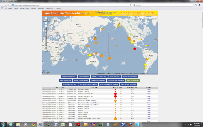
    Post  HigherLove Thu Apr 28, 2011 8:28 am

    Magnitude
    5.3

    Date-Time
    Thursday, April 28, 2011 at 13:07:44 UTC
    Thursday, April 28, 2011 at 06:07:44 AM at epicenter
    Location
    10.219°N, 103.576°W
    Depth
    10 km (6.2 miles)
    Region
    NORTHERN EAST PACIFIC RISE
    Distances
    836 km (520 miles) SSW (209°) from Acapulco, Guerrero, Mexico
    Location Uncertainty
    horizontal +/- 21.8 km (13.5 miles); depth +/- 2.4 km (1.5 miles)
    Parameters
    NST=241, Nph=241, Dmin=976.3 km, Rmss=1.27 sec, Gp=173°,
    M-type=body wave magnitude (Mb), Version=D
    Source
    U.S. Geological Survey, National Earthquake Information Center:
    World Data Center for Seismology, Denver
    Event ID
    usc00030qs


    The Earthquake/Seismic Activity Log - Page 7 Untitl32
    HigherLove
    HigherLove


    Posts : 2357
    Join date : 2011-01-27
    Age : 59

    The Earthquake/Seismic Activity Log - Page 7 Empty Re: The Earthquake/Seismic Activity Log

    Post  HigherLove Thu Apr 28, 2011 8:23 pm

    Magnitude
    4.3

    Date-Time
    Thursday, April 28, 2011 at 23:30:45 UTC
    Friday, April 29, 2011 at 01:30:45 AM at epicenter
    Time of Earthquake in other Time Zones
    Location
    44.814°N, 17.322°E
    Depth
    10.1 km (6.3 miles)
    Region
    BOSNIA AND HERZEGOVINA

    Distances
    11 km (6 miles) ENE of Banja Luka, Bosnia and Herzegovina
    82 km (50 miles) NW of Zenica, Bosnia and Herzegovina
    110 km (68 miles) WNW of Tuzla, Bosnia and Herzegovina
    136 km (84 miles) NW of SARAJEVO, Bosnia and Herzegovina
    Location Uncertainty
    horizontal +/- 13.8 km (8.6 miles); depth +/- 9 km (5.6 miles)
    Parameters
    NST= 76, Nph= 76, Dmin=297.2 km, Rmss=0.56 sec, Gp= 32°,
    M-type=body wave magnitude (Mb), Version=6
    Source
    USGS NEIC (WDCS-D)
    Event ID
    usc00031ac


    Recent earthquakes near Bosnia and Herzegovina
    Time Magnitude Location
    1 hour ago 4.3 Bosnia and Herzegovina Map
    4 days ago 4.1 Malta region Map
    6 days ago 4.4 Aegean Sea Map
    earthquake.usgs.gov

    http://earthquake.usgs.gov/eqcenter/


    The Earthquake/Seismic Activity Log - Page 7 Untitl33
    HigherLove
    HigherLove


    Posts : 2357
    Join date : 2011-01-27
    Age : 59

    The Earthquake/Seismic Activity Log - Page 7 Empty Re: The Earthquake/Seismic Activity Log

    Post  HigherLove Fri Apr 29, 2011 5:27 am

    MAP 5.0 2011/04/29 09:47:13 -19.386 167.842 26.4 VANUATU REGION
    MAP 5.2 2011/04/29 09:38:31 -19.263 167.875 27.2 VANUATU REGION
    MAP 5.6 2011/04/29 08:56:50 3.972 95.847 64.4 OFF THE WEST COAST OF NORTHERN SUMATRA
    MAP 4.7 2011/04/29 08:35:53 36.404 143.336 39.2 OFF THE EAST COAST OF HONSHU, JAPAN
    MAP 5.0 2011/04/29 07:36:23 -19.233 167.722 24.4 VANUATU REGION
    MAP 5.0 2011/04/29 07:31:52 -33.978 -72.208 20.0 OFFSHORE LIBERTADOR O'HIGGINS, CHILE
    MAP 5.1 2011/04/29 07:21:13 -19.147 167.913 29.4 VANUATU REGION
    MAP 4.9 2011/04/29 06:54:49 39.290 142.165 47.7 NEAR THE EAST COAST OF HONSHU, JAPAN
    MAP 4.9 2011/04/29 04:38:38 30.274 130.753 49.5 KYUSHU, JAPAN
    MAP 2.6 2011/04/29 04:08:46 61.242 -151.002 51.2 SOUTHERN ALASKA
    MAP 3.1 2011/04/29 02:03:04 61.906 -152.251 118.2 SOUTHERN ALASKA
    MAP 4.7 2011/04/29 02:00:34 -6.811 102.496 31.1 SOUTHWEST OF SUMATRA, INDONESIA
    MAP 4.9 2011/04/29 01:13:54 37.500 142.345 26.9 OFF THE EAST COAST OF HONSHU, JAPAN
    _______________________________________

    http://earthquake.usgs.gov/earthquakes/recenteqsus/Quakes/quakes_big.php

    Latest Earthquakes M3.0+ in the USA - Past 7 days
    Magnitude 3 and greater earthquakes catalogued in the last week (168 hours) for the ANSS US map area. (Some early events may be obscured by later ones on the maps.) M4.5+ earthquakes are in red.

    The most recent earthquakes are at the top of the list. Times are in Coordinated Universal Time (UTC). Click on the word "map" to see a two-degree tall map displaying the earthquake. Click on an event's "DATE" to get a detailed report.

    Update time = Fri Apr 29 10:23:06 UTC 2011

    MAG UTC DATE-TIME
    y/m/d h:m:s LAT
    deg LON
    deg DEPTH
    km LOCATION
    MAP 3.1 2011/04/29 02:03:04 61.906 -152.251 118.2 52 km ( 32 mi) W of Skwentna, AK
    MAP 3.2 2011/04/28 21:48:19 18.679 -64.582 106.0 24 km ( 15 mi) N of East End-Long Look, British Virgin Islands
    MAP 3.0 2011/04/28 19:54:25 19.172 -64.763 87.2 68 km ( 42 mi) NW of Settlement, British Virgin Islands
    MAP 3.2 2011/04/28 19:16:37 19.036 -64.764 100.6 58 km ( 36 mi) NW of Settlement, British Virgin Islands
    MAP 3.3 2011/04/28 13:58:48 19.666 -64.894 51.2 120 km ( 75 mi) NNW of Settlement, British Virgin Islands
    MAP 4.3 2011/04/28 13:24:35 53.804 -165.097 39.3 60 km ( 37 mi) SE of Akutan, AK
    MAP 4.1 2011/04/28 04:58:35 30.704 -105.762 10.0 66 km ( 41 mi) S of Fort Hancock, TX
    MAP 3.3 2011/04/28 01:07:40 19.192 -64.341 36.5 51 km ( 32 mi) N of Settlement, British Virgin Islands
    MAP 4.3 2011/04/28 01:03:42 30.775 -105.729 10.2 58 km ( 36 mi) SW of Sierra Blanca, TX
    MAP 3.7 2011/04/28 00:49:56 38.418 -118.717 2.4 14 km ( 9 mi) SW of Hawthorne, NV
    MAP 3.3 2011/04/27 20:50:53 54.854 -160.374 15.0 54 km ( 34 mi) S of Sand Point, AK
    MAP 4.3 2011/04/27 19:19:20 38.414 -118.718 2.6 15 km ( 9 mi) SW of Hawthorne, NV
    MAP 3.1 2011/04/27 14:25:06 51.346 -178.229 26.2 125 km ( 77 mi) WSW of Adak, AK
    MAP 3.5 2011/04/27 13:23:35 38.409 -118.726 0.7 16 km ( 10 mi) SW of Hawthorne, NV
    MAP 3.4 2011/04/27 07:45:32 60.845 -149.280 22.9 9 km ( 6 mi) ESE of Sunrise, AK
    MAP 3.4 2011/04/27 03:42:47 19.181 -67.891 69.7 106 km ( 66 mi) NE of Hig�ey, Dominican Republic
    MAP 5.6 2011/04/26 21:10:26 27.439 -111.598 15.1 69 km ( 43 mi) E of Santa Rosal�a, Mexico
    MAP 3.2 2011/04/26 18:55:26 35.958 -117.658 2.9 28 km ( 17 mi) ESE of Coso Junction, CA
    MAP 3.9 2011/04/26 17:43:08 38.813 -122.817 3.5 2 km ( 1 mi) NNW of The Geysers, CA
    MAP 3.2 2011/04/26 16:16:44 35.968 -117.647 3.6 28 km ( 18 mi) ESE of Coso Junction, CA
    MAP 3.3 2011/04/26 08:02:49 40.230 -121.053 2.0 2 km ( 2 mi) ESE of East Shore, CA
    MAP 3.4 2011/04/26 07:25:42 19.136 -64.595 48.4 54 km ( 33 mi) NNW of Settlement, British Virgin Islands
    MAP 3.3 2011/04/26 05:26:57 51.215 -180.847 20.0 300 km (186 mi) WSW of Adak, AK
    MAP 4.9 2011/04/26 01:28:36 51.313 -180.843 41.2 297 km (184 mi) W of Adak, AK
    MAP 4.8 2011/04/25 19:29:15 59.062 -152.532 57.4 48 km ( 30 mi) SW of Nanwalek, AK
    MAP 3.7 2011/04/25 14:17:28 55.663 -158.050 13.3 74 km ( 46 mi) SSE of Chignik, AK
    MAP 3.1 2011/04/25 05:24:32 18.917 -64.451 74.3 25 km ( 15 mi) NW of Settlement, British Virgin Islands
    MAP 3.2 2011/04/25 03:21:36 18.456 -67.366 12.0 18 km ( 11 mi) NW of Rinc�n, PR
    MAP 3.5 2011/04/25 03:13:44 19.213 -64.586 45.0 61 km ( 38 mi) NNW of Settlement, British Virgin Islands
    MAP 3.4 2011/04/25 01:08:14 17.978 -64.986 4.0 32 km ( 20 mi) NNW of Frederiksted Southeast, US Virgin Islands
    MAP 3.3 2011/04/25 00:03:21 38.411 -118.725 0.4 15 km ( 10 mi) SW of Hawthorne, NV
    MAP 3.0 2011/04/24 17:43:50 52.694 -168.136 21.7 56 km ( 35 mi) ESE of Nikolski, AK
    MAP 3.2 2011/04/24 06:18:57 35.225 -92.379 5.5 1 km ( 1 mi) ESE of Greenbrier, AR
    MAP 3.3 2011/04/24 03:04:06 19.144 -64.622 86.5 56 km ( 35 mi) NW of Settlement, British Virgin Islands
    MAP 3.5 2011/04/24 02:30:26 38.420 -118.717 2.0 14 km ( 9 mi) SW of Hawthorne, NV
    MAP 3.1 2011/04/23 22:03:53 57.266 -155.140 45.1 58 km ( 36 mi) SW of Karluk, AK
    MAP 3.6 2011/04/23 20:49:29 33.021 -116.318 4.3 22 km ( 14 mi) SW of Ocotillo Wells, CA
    MAP 3.4 2011/04/23 19:42:57 38.832 -122.794 2.7 4 km ( 2 mi) NNE of The Geysers, CA
    MAP 3.0 2011/04/23 17:13:14 54.496 -161.553 14.0 81 km ( 50 mi) SE of King Cove, AK
    MAP 3.1 2011/04/23 12:20:31 35.267 -92.359 5.2 5 km ( 3 mi) NNE of Greenbrier, AR
    MAP 4.7 2011/04/23 09:20:31 51.739 -175.371 35.1 89 km ( 55 mi) E of Adak, AK
    MAP 3.6 2011/04/23 03:12:44 19.439 -64.430 57.2 80 km ( 49 mi) N of Settlement, British Virgin Islands
    MAP 3.3 2011/04/22 18:52:18 39.485 -118.073 4.5 23 km ( 14 mi) S of Dixie Valley, NV
    MAP 3.4 2011/04/22 16:16:26 53.554 -164.861 47.3 90 km ( 56 mi) SE of Akutan, AK
    MAP 3.0 2011/04/22 11:45:07 54.800 -160.637 21.3 60 km ( 38 mi) S of Sand Point, AK
    _______________________________________________

    tick tock tick tock

    Magnitude
    1.6
    Date-Time
    Friday, April 29, 2011 at 08:55:42 UTC
    Friday, April 29, 2011 at 01:55:42 AM at epicenter
    Location
    40.467°N, 121.544°W
    Depth
    5.5 km (3.4 miles)
    Region
    LASSEN PEAK AREA, CALIFORNIA
    Distances
    13 km (8 miles) ESE (117°) from Viola, CA
    13 km (8 miles) N (9°) from Mineral, CA
    27 km (17 miles) E (97°) from Shingletown, CA
    47 km (29 miles) SSE (167°) from Burney, CA
    71 km (44 miles) E (100°) from Redding, CA
    213 km (132 miles) N (358°) from Sacramento, CA
    Location Uncertainty
    horizontal +/- 0.5 km (0.3 miles); depth +/- 0.9 km (0.6 miles)
    Parameters
    Nph= 8, Dmin=2 km, Rmss=0.04 sec, Gp=162°,
    M-type=duration magnitude (Md), Version=0
    Source
    California Integrated Seismic Net:
    USGS Caltech CGS UCB UCSD UNR
    Event ID
    nc71567596
    HigherLove
    HigherLove


    Posts : 2357
    Join date : 2011-01-27
    Age : 59

    The Earthquake/Seismic Activity Log - Page 7 Empty Re: The Earthquake/Seismic Activity Log

    Post  HigherLove Fri Apr 29, 2011 9:57 am

    The Earthquake/Seismic Activity Log - Page 7 Untitl34

    Friday April 29 2011, 14:26:05 UTC 30 minutes ago Northern California 1.0 2.5 Detail
    Friday April 29 2011, 13:35:20 UTC 80 minutes ago Southern Alaska 3.0 135.8 Detail
    Friday April 29 2011, 13:20:23 UTC 95 minutes ago Southern California 1.6 11.6 Detail
    Friday April 29 2011, 13:17:49 UTC 98 minutes ago Nevada 1.2 0.0 Detail
    Friday April 29 2011, 13:12:45 UTC 103 minutes ago Taiwan region 5.5 176.7 Detail
    Friday April 29 2011, 13:08:31 UTC 107 minutes ago Vanuatu region 5.0 27.2 Detail
    Friday April 29 2011, 12:45:28 UTC 2 hours ago Northern California 1.0 1.7 Detail
    Friday April 29 2011, 12:45:28 UTC 2 hours ago Northern California 1.0 1.7 Detail
    Friday April 29 2011, 12:44:03 UTC 2 hours ago Southern California 1.5 9.6 Detail
    Friday April 29 2011, 12:44:03 UTC 2 hours ago Southern California 1.5 9.6 Detail
    Friday April 29 2011, 12:43:25 UTC 2 hours ago Baja California, Mexico 2.2 7.4 Detail
    Friday April 29 2011, 12:26:20 UTC 2 hours ago Southern California 1.5 9.1 Detail
    Friday April 29 2011, 12:22:59 UTC 2 hours ago Nevada 1.1 0.0 Detail
    Friday April 29 2011, 12:09:41 UTC 2 hours ago Nevada 1.3 3.6 Detail
    Friday April 29 2011, 12:09:41 UTC 2 hours ago Nevada 1.3 3.6 Detail
    Friday April 29 2011, 11:47:32 UTC 3 hours ago Kenai Peninsula, Alaska 1.8 38.4 Detail
    Friday April 29 2011, 11:06:48 UTC 3 hours ago Bonin Islands, Japan region 4.7 10.2 Detail
    Friday April 29 2011, 10:59:37 UTC 3 hours ago Nevada 1.7 0.9 Detail
    Friday April 29 2011, 10:28:35 UTC 4 hours ago Nevada 2.0 4.0 Detail
    Friday April 29 2011, 10:27:23 UTC 4 hours ago Nevada 2.1 4.0 Detail
    Friday April 29 2011, 10:24:07 UTC 4 hours ago Southern Alaska 1.3 41.7 Detail
    Friday April 29 2011, 10:24:07 UTC 4 hours ago Southern Alaska 1.3 41.7 Detail
    Friday April 29 2011, 09:48:30 UTC 5 hours ago Northern California 1.3 2.2 Detail
    Friday April 29 2011, 09:48:30 UTC 5 hours ago Northern California 1.3 2.2 Detail
    Friday April 29 2011, 09:47:13 UTC 5 hours ago Vanuatu region 5.0 26.4 Detail
    HigherLove
    HigherLove


    Posts : 2357
    Join date : 2011-01-27
    Age : 59

    The Earthquake/Seismic Activity Log - Page 7 Empty Re: The Earthquake/Seismic Activity Log

    Post  HigherLove Sat Apr 30, 2011 7:42 am

    MAP 4.6 2011/04/30 12:04:45 -12.130 166.539 35.0 SANTA CRUZ ISLANDS
    MAP 2.9 2011/04/30 11:14:20 63.285 -144.900 15.6 CENTRAL ALASKA
    MAP 4.9 2011/04/30 11:13:50 35.136 141.834 23.3 NEAR THE EAST COAST OF HONSHU, JAPAN
    MAP 4.1 2011/04/30 10:31:05 45.756 143.282 315.9 HOKKAIDO, JAPAN REGION
    MAP 4.7 2011/04/30 09:03:40 -5.322 146.430 188.0 EASTERN NEW GUINEA REG, PAPUA NEW GUINEA
    MAP 4.9 2011/04/30 08:35:39 24.689 121.874 74.6 TAIWAN
    MAP 6.0 2011/04/30 08:19:17 6.878 -82.287 9.9 SOUTH OF PANAMA
    MAP 2.8 2011/04/30 07:06:50 60.452 -152.321 103.8 SOUTHERN ALASKA
    MAP 2.5 2011/04/30 06:54:54 17.893 -65.734 12.6 PUERTO RICO REGION
    MAP 3.2 2011/04/30 06:49:26 18.869 -64.760 4.3 VIRGIN ISLANDS REGION
    MAP 4.6 2011/04/30 06:39:55 14.953 42.084 10.0 NEAR THE WEST COAST OF YEMEN
    MAP 3.6 2011/04/30 06:28:21 17.932 -64.699 160.3 VIRGIN ISLANDS REGION
    MAP 4.3 2011/04/30 06:07:53 28.764 -113.178 10.0 BAJA CALIFORNIA, MEXICO
    MAP 4.8 2011/04/30 06:04:23 36.754 141.094 20.2 NEAR THE EAST COAST OF HONSHU, JAPAN
    MAP 4.6 2011/04/30 05:47:00 37.399 141.243 25.8 NEAR THE EAST COAST OF HONSHU, JAPAN
    MAP 5.5 2011/04/30 05:45:35 -3.263 148.622 10.2 BISMARCK SEA
    MAP 5.2 2011/04/30 05:06:36 36.787 141.092 40.3 NEAR THE EAST COAST OF HONSHU, JAPAN
    MAP 2.9 2011/04/30 04:17:16 33.227 -116.052 9.9 SOUTHERN CALIFORNIA
    MAP 3.8 2011/04/30 03:16:54 57.872 -157.580 167.8 ALASKA PENINSULA
    MAP 4.7 2011/04/30 01:54:25 39.623 142.066 34.6 NEAR THE EAST COAST OF HONSHU, JAPAN

    The Earthquake/Seismic Activity Log - Page 7 Untitl35


      Current date/time is Mon Nov 18, 2024 10:41 pm