tMoA

Would you like to react to this message? Create an account in a few clicks or log in to continue.
tMoA

~ The only Home on the Web You'll ever need ~

+21
Aquaries1111
giovonni
arvan33
Floyd
lawlessline
JesterTerrestrial
THEeXchanger
newel
Brook
greybeard
Mercuriel
Sanicle
devakas
hobbit
mudra
burgundia
lindabaker
LeeEllisMusic
MargueriteBee
Carol
HigherLove
25 posters

    The Earthquake/Seismic Activity Log

    HigherLove
    HigherLove


    Posts : 2357
    Join date : 2011-01-27
    Age : 59

    The Earthquake/Seismic Activity Log - Page 5 Empty Re: The Earthquake/Seismic Activity Log

    Post  HigherLove Wed Apr 20, 2011 7:05 am

    U.S 2.5+ / World 4.5+


    MAG UTC DATE-TIME
    y/m/d h:m:s LAT
    deg LON
    deg DEPTH
    km Region
    MAP 4.7 2011/04/20 11:31:47 4.713 94.514 39.9 OFF THE WEST COAST OF NORTHERN SUMATRA
    MAP 2.5 2011/04/20 10:37:09 32.227 -115.386 12.4 BAJA CALIFORNIA, MEXICO
    MAP 5.0 2011/04/20 08:35:15 -30.087 -178.070 60.7 KERMADEC ISLANDS, NEW ZEALAND
    MAP 4.4 2011/04/20 08:30:26 36.960 140.926 37.3 NEAR THE EAST COAST OF HONSHU, JAPAN
    MAP 4.7 2011/04/20 08:18:52 37.895 68.642 10.4 TAJIKISTAN
    MAP 4.6 2011/04/20 07:52:19 36.538 141.610 34.5 NEAR THE EAST COAST OF HONSHU, JAPAN
    MAP 3.5 2011/04/20 07:35:09 59.582 -153.030 96.1 SOUTHERN ALASKA
    MAP 4.6 2011/04/20 07:12:56 53.920 170.863 33.5 NEAR ISLANDS, ALEUTIAN ISLANDS, ALASKA
    MAP 2.6 2011/04/20 05:44:24 38.400 -118.739 0.0 NEVADA
    MAP 3.3 2011/04/20 05:13:13 19.120 -64.478 58.8 VIRGIN ISLANDS REGION
    MAP 3.0 2011/04/20 03:46:52 18.466 -66.182 57.0 SAN JUAN URBAN AREA, PUERTO RICO
    MAP 4.5 2011/04/20 03:40:43 -38.187 -73.737 34.2 OFFSHORE BIO-BIO, CHILE
    MAP 4.8 2011/04/20 03:09:14 -20.848 -175.530 104.6 TONGA
    MAP 2.9 2011/04/20 02:49:04 64.033 -149.057 0.0 CENTRAL ALASKA
    MAP 2.7 2011/04/20 00:44:33 59.837 -150.781 42.7 KENAI PENINSULA, ALASKA
    MAP 2.5 2011/04/20 00:03:11 18.911 -66.521 14.8 PUERTO RICO REGION
    HigherLove
    HigherLove


    Posts : 2357
    Join date : 2011-01-27
    Age : 59

    The Earthquake/Seismic Activity Log - Page 5 Empty Re: The Earthquake/Seismic Activity Log

    Post  HigherLove Wed Apr 20, 2011 7:08 am

    The Geysers have been quiet since last night. ?????????????

    In general, activity at the Geysers seems to have decreased a bit in the last few days.

    __________________

    NOTE: Old Faithful (Calistoga, CA) often changes behavior before large quakes. I have not heard anything so far, but I have not looked, either.

    TBC/TBA

    _________________

    Water for the Old Faithful Geyser of California comes from an underground river. When this water flows over the hot molten magma deep in the earth, it boils and expands and is collected in large cavities. Under tremendous pressure from the heat, and assisted by a constriction of the passage upward, the superheated water is forced through the fissures and fractures and erupts with an outpouring of steam followed by a fulmination of hot dancing water.

    Under normal conditions, the water, the heat and the underground structure all remain constant and for this reason Old Faithful erupts regularly. Conditions which cause deviations from the normal pattern seem to relate to earthquakes. The Old Faithful Geyser of California is proving itself a predictor of quakes.


    Earthquakes

    From two days to two weeks prior to an earthquake, the Old Faithful Geyser of California gives warning by delaying its regular performance from the average thirty minutes to a longer interval. During this prolonged interval, it may send up "splits," small eruptions to no more than two or three feet in height, every few minutes. Finally, after the long delay, a 60-foot column of water and steam shoots upward.

    The Geyser will return to its normal pattern unless interrupted by further tectonic stresses. Several scientists have studied the Geyser and one scientist has set up an infrared heat detector nearby. When the Geyser erupts, the detector is activated and information is relayed into an office where a taped printout automatically records all the eruptions day and night. The scientists then can use such information to determine whether or not Old Faithful's digressions from normal behavior correlate with the advent of an earthquake, and records are kept for future comparisons. The earthquake activity is not located at the Geyser, but within 500 miles or more from the area.

    A scientific study sponsored by the Carnegie Institution of Washington DC, is being conducted in order to document the possible correlation between the Geyser eruptions and earthquake activity.

    http://www.oldfaithfulgeyser.com/information.html

    ___________

    Geysers and the Earth's Plumbing Systems

    Introduction

    Geysers are essentially hot springs that become thermodynamically and hydrodynamically unstable. However, geysers are extremely rare on the surface of the earth, indicating that a complex set of parameters must be exactly right for geysers to occur. Figure 1 shows locations and Table 1 lists names of geyser fields of the world. It is worth noting that there are only approximately fifty geyser fields known to exist on earth and around two-thirds of those fifty contain five or fewer active geysers. Yellowstone National Park in Wyoming, U.S.A. has, by nearly an order of magnitude, more geysers than any other field known, and has been the site of extensive study of the properties and characteristics of geysers.

    Because geysers are so rare, there have been several investigations into the conditions that must exist for geyser activity. It has been found that at least three essential conditions must be met, but there are many other contributing factors that influence the type and frequency of eruptions. The basic elements of a geyser are: 1) a water supply, 2) a heat source, and 3) a reservoir and associated plumbing system (Figure 2).

    http://www.umich.edu/~gs265/geysers.html

    There is a generally a strong correlation between earthquake activity and geyser behavior. This phenomena has been observed for centuries, but only recently have the changes in geyser behavior been documented. The 1959 Hegben Lake earthquake has had the most dramatic effect on Yellowstone geysers of any earthquake since the park's discovery (Rhinehart, 1980). Since the epicenter was so close to Yellowstone (only about 50 km away) the effects were significant. Immediately after the earthquake, all the geysers in the park erupted, and the average temperature in geysers and springs increased by an average of 2°C. Some geysers that were previously dormant became active, ostensibly by the opening of sealed channels along planes of weakness, and several active geysers changed their eruptive behavior. However, geyser response to earthquakes seems somewhat variable. Old Faithful in Yellowstone was the only geyser in the park that did not change its eruptive behavior after the Hegben Lake earthquake (Rhinehart, 1980). However, it has responded to several other earthquakes with epicenters much farther away, such as the magnitude 8.4 earthquake in Alaska in 1964. This indicates that the profound changes in geyser activity due to earthquakes are not due to slip along faults so much as by changes in regional strain. Since geysers record earthquake activity in a reasonably consistent manner, there have been several studies on whether geysers could be used as predictors for earthquake activity. Rhinehart (1980) states that in his detailed studies of geysers, there have been no systematic correlations between earthquakes and geyser activity. A more recent study by Silver and Valette-Silver (1992) showed that some geysers in California show changes in observable activity before nearby earthquake activity. They surmise that, although the response of geysers to tectonic strain is not well understood, there are two basic mechanisms by which seismic activity could affect geyser behavior. In the first, changes in the regional strain field change the volumetric flow velocity into the reservoir, thus affecting the interval between geyser eruptions. In another scenario, the permeability of the plumbing system could change due to strain-induced changes in microfractures in the geyser reservoir.


    Last edited by HigherLove on Wed Apr 20, 2011 7:36 am; edited 4 times in total
    HigherLove
    HigherLove


    Posts : 2357
    Join date : 2011-01-27
    Age : 59

    The Earthquake/Seismic Activity Log - Page 5 Empty Re: The Earthquake/Seismic Activity Log

    Post  HigherLove Wed Apr 20, 2011 7:26 am

    Magnitude
    4.7
    Date-Time
    Wednesday, April 20, 2011 at 12:04:43 UTC
    Wednesday, April 20, 2011 at 07:04:43 AM at epicenter
    Location
    33.937°S, 73.146°W
    Depth
    20.7 km (12.9 miles)
    Region
    OFF THE COAST OF VALPARAISO, CHILE
    Distances
    167 km (104 miles) SW (235°) from Valparaiso, Chile
    217 km (135 miles) NW (321°) from Talca, Chile
    234 km (146 miles) WSW (257°) from SANTIAGO, Chile
    Location Uncertainty
    horizontal +/- 22.1 km (13.7 miles); depth +/- 8.7 km (5.4 miles)
    Parameters
    NST= 75, Nph= 77, Dmin=224.9 km, Rmss=0.36 sec, Gp=144°,
    M-type=body wave magnitude (Mb), Version=7
    Source
    U.S. Geological Survey, National Earthquake Information Center:
    World Data Center for Seismology, Denver
    Event ID
    usc0002vlm
    HigherLove
    HigherLove


    Posts : 2357
    Join date : 2011-01-27
    Age : 59

    The Earthquake/Seismic Activity Log - Page 5 Empty Re: The Earthquake/Seismic Activity Log

    Post  HigherLove Wed Apr 20, 2011 7:48 am

    And now we have activity near Mt. Lassen. This means rumbling around both volcanoes, with Mt. Shasta being the other (they are visible at the same time, btw).

    Magnitude
    2.4
    Date-Time
    Wednesday, April 20, 2011 at 12:30:58 UTC
    Wednesday, April 20, 2011 at 05:30:58 AM at epicenter
    Location
    40.254°N, 121.183°W
    Depth
    0 km (~0 mile) (poorly constrained)
    Region
    NORTHERN CALIFORNIA
    Distances
    4 km (3 miles) N (354°) from Almanor, CA
    6 km (4 miles) NNW (337°) from Prattville, CA
    7 km (4 miles) SE (141°) from Chester, CA
    49 km (30 miles) WSW (248°) from Susanville, CA
    190 km (118 miles) N (7°) from Sacramento, CA
    Location Uncertainty
    horizontal +/- 1 km (0.6 miles); depth +/- 3.5 km (2.2 miles)
    Parameters
    Nph= 26, Dmin=26 km, Rmss=0.28 sec, Gp=122°,
    M-type=duration magnitude (Md), Version=1
    Source
    California Integrated Seismic Net:
    USGS Caltech CGS UCB UCSD UNR
    Event ID
    nc71561631

    The Earthquake/Seismic Activity Log - Page 5 Untitl23
    HigherLove
    HigherLove


    Posts : 2357
    Join date : 2011-01-27
    Age : 59

    The Earthquake/Seismic Activity Log - Page 5 Empty Re: The Earthquake/Seismic Activity Log

    Post  HigherLove Wed Apr 20, 2011 6:49 pm

    Magnitude
    4.7
    Date-Time
    Wednesday, April 20, 2011 at 22:27:59 UTC
    Wednesday, April 20, 2011 at 05:27:59 PM at epicenter
    Time of Earthquake in other Time Zones
    Location
    3.872°S, 79.484°W
    Depth
    97.2 km (60.4 miles)
    Region
    NEAR THE COAST OF ECUADOR
    Distances
    32 km (19 miles) WNW of Loja, Ecuador
    85 km (52 miles) SE of Machala, Ecuador
    112 km (69 miles) ESE of Tumbes, Peru
    418 km (259 miles) SSW of QUITO, Ecuador
    Location Uncertainty
    horizontal +/- 28.7 km (17.8 miles); depth +/- 12.1 km (7.5 miles)
    Parameters
    NST= 82, Nph= 83, Dmin=468.7 km, Rmss=0.75 sec, Gp=151°,
    M-type=body wave magnitude (Mb), Version=5
    Source
    USGS NEIC (WDCS-D)
    Event ID
    usc0002vzd
    HigherLove
    HigherLove


    Posts : 2357
    Join date : 2011-01-27
    Age : 59

    The Earthquake/Seismic Activity Log - Page 5 Empty Re: The Earthquake/Seismic Activity Log

    Post  HigherLove Wed Apr 20, 2011 9:18 pm

    Magnitude
    6.0

    Date-Time
    Thursday, April 21, 2011 at 01:54:40 UTC
    Thursday, April 21, 2011 at 11:54:40 AM at epicenter
    Location
    40.319°N, 143.676°E
    Depth
    3.7 km (2.3 miles) (poorly constrained)
    Region
    OFF THE EAST COAST OF HONSHU, JAPAN
    Distances
    185 km (115 miles) E (96°) from Hachinohe, Honshu, Japan
    227 km (141 miles) ENE (72°) from Morioka, Honshu, Japan
    256 km (159 miles) ESE (102°) from Aomori, Honshu, Japan
    621 km (386 miles) NNE (32°) from TOKYO, Japan
    Location Uncertainty
    horizontal +/- 16.5 km (10.3 miles); depth +/- 5.9 km (3.7 miles)
    Parameters
    NST=370, Nph=370, Dmin=193.7 km, Rmss=0.65 sec, Gp= 65°,
    M-type=regional moment magnitude (Mw), Version=A
    Source
    U.S. Geological Survey, National Earthquake Information Center:
    World Data Center for Seismology, Denver
    Event ID
    usc0002w18
    HigherLove
    HigherLove


    Posts : 2357
    Join date : 2011-01-27
    Age : 59

    The Earthquake/Seismic Activity Log - Page 5 Empty Re: The Earthquake/Seismic Activity Log

    Post  HigherLove Wed Apr 20, 2011 9:25 pm

    The Earthquake/Seismic Activity Log - Page 5 Today_10
    HigherLove
    HigherLove


    Posts : 2357
    Join date : 2011-01-27
    Age : 59

    The Earthquake/Seismic Activity Log - Page 5 Empty Re: The Earthquake/Seismic Activity Log

    Post  HigherLove Wed Apr 20, 2011 9:28 pm

    Just Cal-Neva again -

    map 1.8 2011/04/20 18:58:47 35.157N 117.549W 8.1 19 km (12 mi) NNE of Boron, CA
    map 1.1 2011/04/20 18:35:16 38.793N 122.811W 3.2 1 km ( 0 mi) SW of The Geysers, CA
    map 1.5 2011/04/20 18:28:43 37.627N 118.881W 9.9 9 km ( 5 mi) E of Mammoth Lakes, CA
    map 1.3 2011/04/20 18:24:44 33.094N 115.716W 15.2 11 km ( 7 mi) NW of Westmorland, CA
    map 1.4 2011/04/20 18:07:42 35.721N 118.034W 5.7 17 km (11 mi) ENE of Onyx, CA
    map 1.6 2011/04/20 17:50:20 37.562N 116.975W 38.5 31 km (20 mi) SE of West Spring, NV
    map 2.3 2011/04/20 17:38:36 38.819N 122.824W 2.4 3 km ( 2 mi) NNW of The Geysers, CA
    map 1.6 2011/04/20 17:03:32 32.655N 115.975W 7.3 10 km ( 6 mi) SSE of Ocotillo, CA
    map 1.0 2011/04/20 16:59:17 33.645N 116.782W 6.1 13 km ( 8 mi) SSW of Idyllwild, CA
    map 1.3 2011/04/20 16:39:20 33.415N 116.808W 20.0 8 km ( 5 mi) NE of Palomar Observatory, CA
    map 1.4 2011/04/20 15:35:18 32.930N 116.298W 9.7 24 km (15 mi) ENE of Pine Valley, CA
    map 1.0 2011/04/20 14:40:53 38.786N 122.745W 1.8 5 km ( 3 mi) WNW of Anderson Springs, CA
    map 1.6 2011/04/20 14:18:54 36.883N 121.600W 3.5 4 km ( 2 mi) E of Aromas, CA
    map 1.7 2011/04/20 14:07:09 33.000N 116.343W 11.3 24 km (15 mi) ESE of Julian, CA
    map 1.4 2011/04/20 13:27:41 35.818N 115.321W 0.9 10 km ( 6 mi) E of Goodsprings, NV
    map 1.5 2011/04/20 13:14:37 38.791N 122.777W 2.4 3 km ( 2 mi) ESE of The Geysers, CA
    map 1.1 2011/04/20 13:05:47 34.034N 117.268W 16.3 2 km ( 1 mi) SW of Loma Linda, CA
    map 1.4 2011/04/20 13:00:13 32.826N 117.056W 0.0 7 km ( 4 mi) WSW of Santee, CA
    map 1.6 2011/04/20 12:56:55 35.793N 121.136W 4.4 17 km (11 mi) NNE of San Simeon, CA
    map 2.0 2011/04/20 11:59:47 37.185N 116.515W 9.7 37 km (23 mi) NE of Beatty, NV
    map 1.9 2011/04/20 11:54:42 38.813N 122.786W 2.6 2 km ( 2 mi) NE of The Geysers, CA
    map 1.4 2011/04/20 11:38:53 33.987N 116.846W 13.5 8 km ( 5 mi) NE of Banning, CA
    map 1.2 2011/04/20 11:33:15 36.733N 121.033W 0.9 24 km (15 mi) NNE of Pinnacles, CA
    map 1.4 2011/04/20 11:17:22 38.785N 122.783W 3.0 3 km ( 2 mi) SE of The Geysers, CA
    map 1.1 2011/04/20 11:03:07 33.057N 116.388W 13.9 18 km (11 mi) E of Julian, CA
    map 1.9 2011/04/20 11:01:54 38.379N 118.747W 0.1 19 km (12 mi) SW of Hawthorne, NV
    map 1.9 2011/04/20 10:38:05 38.566N 122.813W 5.0 2 km ( 1 mi) NNW of Windsor, CA
    map 1.4 2011/04/20 10:33:50 32.634N 115.713W 5.5 18 km (11 mi) S of Seeley, CA
    map 1.0 2011/04/20 10:33:43 33.148N 116.445W 9.9 13 km ( 8 mi) SSW of Borrego Springs, CA
    map 1.2 2011/04/20 10:15:15 37.653N 122.061W 3.2 2 km ( 1 mi) NE of Hayward, CA
    map 1.0 2011/04/20 09:24:38 36.036N 117.775W 3.6 16 km (10 mi) E of Coso Junction, CA
    map 1.6 2011/04/20 09:18:54 38.414N 118.716W 3.8 15 km ( 9 mi) SSW of Hawthorne, NV
    map 1.0 2011/04/20 08:58:42 35.146N 118.406W 0.0 4 km ( 3 mi) ENE of Tehachapi, CA
    map 1.5 2011/04/20 08:47:51 37.904N 121.974W 11.5 5 km ( 3 mi) SW of Clayton, CA
    map 1.9 2011/04/20 08:03:04 38.603N 122.384W 6.8 6 km ( 4 mi) ENE of Angwin, CA
    map 2.4 2011/04/20 07:25:01 38.370N 118.758W 1.4 21 km (13 mi) SW of Hawthorne, NV
    map 1.0 2011/04/20 07:07:16 37.731N 121.985W 7.8 4 km ( 3 mi) SW of San Ramon, CA
    map 2.5 2011/04/20 06:43:33 35.607N 116.911W 4.9 28 km (18 mi) N of Goldstone Lake, CA
    map 1.9 2011/04/20 06:25:44 34.713N 116.120W 9.5 4 km ( 2 mi) ESE of Ludlow, CA
    map 1.3 2011/04/20 06:23:53 32.660N 115.933W 6.8 11 km ( 7 mi) SE of Ocotillo, CA
    map 1.0 2011/04/20 05:41:17 36.956N 121.590W 5.2 6 km ( 4 mi) S of Gilroy, CA
    map 2.4 2011/04/20 05:30:58 40.243N 121.185W 0.5 3 km ( 2 mi) NNW of Almanor, CA
    map 2.0 2011/04/20 05:29:09 37.481N 118.838W 5.6 17 km (10 mi) WSW of Toms Place, CA
    map 1.7 2011/04/20 05:22:03 38.434N 118.732W 1.3 14 km ( 9 mi) SW of Hawthorne, NV
    map 1.6 2011/04/20 04:24:37 38.419N 118.736W 5.8 15 km (10 mi) SW of Hawthorne, NV
    map 1.6 2011/04/20 04:23:12 38.419N 118.738W 5.6 15 km (10 mi) SW of Hawthorne, NV
    map 2.2 2011/04/20 03:37:09 32.282N 115.391W 10.0 26 km (16 mi) W of Guadalupe Victoria, Baja California, Mexico
    map 1.6 2011/04/20 03:33:26 36.986N 121.640W 3.0 6 km ( 4 mi) WSW of Gilroy, CA
    map 1.0 2011/04/20 03:33:23 33.714N 116.769W 18.0 6 km ( 4 mi) SW of Idyllwild, CA
    map 1.0 2011/04/20 01:26:38 33.505N 116.488W 14.6 18 km (11 mi) ESE of Anza, CA
    map 1.2 2011/04/20 01:02:41 38.399N 118.736W 5.4 17 km (11 mi) SW of Hawthorne, NV
    map 2.1 2011/04/20 00:42:59 32.301N 115.369W 10.0 24 km (15 mi) W of Guadalupe Victoria, Baja California, Mexico
    HigherLove
    HigherLove


    Posts : 2357
    Join date : 2011-01-27
    Age : 59

    The Earthquake/Seismic Activity Log - Page 5 Empty Re: The Earthquake/Seismic Activity Log

    Post  HigherLove Wed Apr 20, 2011 9:34 pm

    World -- 2.5+


    MAP 3.6 2011/04/20 22:55:01 19.643 -68.200 82.3 DOMINICAN REPUBLIC REGION
    MAP 4.7 2011/04/20 22:28:00 -3.872 -79.484 97.2 NEAR THE COAST OF ECUADOR
    MAP 3.0 2011/04/20 21:37:22 19.802 -64.922 29.0 NORTH OF THE VIRGIN ISLANDS
    MAP 4.8 2011/04/20 18:21:44 27.362 -111.493 3.1 GULF OF CALIFORNIA
    MAP 2.9 2011/04/20 17:40:43 19.219 -154.885 9.4 HAWAII REGION, HAWAII
    MAP 2.9 2011/04/20 16:52:28 19.011 -66.068 37.5 PUERTO RICO REGION
    MAP 4.7 2011/04/20 16:33:22 38.217 141.655 62.3 NEAR THE EAST COAST OF HONSHU, JAPAN
    MAP 2.5 2011/04/20 16:01:38 18.619 -64.490 59.3 VIRGIN ISLANDS REGION
    MAP 4.7 2011/04/20 15:35:33 -41.309 -89.561 10.0 SOUTHEAST OF EASTER ISLAND
    MAP 4.4 2011/04/20 13:55:29 -5.604 149.551 146.8 NEW BRITAIN REGION, PAPUA NEW GUINEA
    MAP 2.5 2011/04/20 13:43:34 35.607 -116.911 4.9 SOUTHERN CALIFORNIA
    MAP 3.7 2011/04/20 13:36:56 60.808 -147.119 12.4 SOUTHERN ALASKA
    MAP 2.5 2011/04/20 13:19:22 31.866 -114.923 10.0 BAJA CALIFORNIA, MEXICO
    MAP 2.9 2011/04/20 12:44:29 61.630 -151.555 92.9 SOUTHERN ALASKA
    MAP 4.7 2011/04/20 12:04:44 -33.937 -73.146 20.7 OFF THE COAST OF VALPARAISO, CHILE
    MAP 4.7 2011/04/20 11:31:47 4.713 94.514 39.9 OFF THE WEST COAST OF NORTHERN SUMATRA
    MAP 5.0 2011/04/20 08:35:15 -30.087 -178.070 60.7 KERMADEC ISLANDS, NEW ZEALAND
    MAP 4.4 2011/04/20 08:30:26 36.960 140.926 37.3 NEAR THE EAST COAST OF HONSHU, JAPAN
    MAP 4.7 2011/04/20 08:18:52 37.895 68.642 10.4 TAJIKISTAN
    MAP 4.6 2011/04/20 07:52:19 36.538 141.610 34.5 NEAR THE EAST COAST OF HONSHU, JAPAN
    MAP 3.5 2011/04/20 07:35:09 59.565 -152.958 94.5 SOUTHERN ALASKA
    MAP 4.6 2011/04/20 07:12:56 53.920 170.863 33.5 NEAR ISLANDS, ALEUTIAN ISLANDS, ALASKA
    MAP 2.8 2011/04/20 05:49:40 38.405 -118.722 0.0 NEVADA
    MAP 2.7 2011/04/20 05:44:24 38.410 -118.740 1.6 NEVADA
    MAP 3.3 2011/04/20 05:13:13 19.120 -64.478 58.8 VIRGIN ISLANDS REGION
    MAP 3.0 2011/04/20 03:46:52 18.466 -66.182 57.0 SAN JUAN URBAN AREA, PUERTO RICO
    MAP 4.5 2011/04/20 03:40:43 -38.187 -73.737 34.2 OFFSHORE BIO-BIO, CHILE
    MAP 4.8 2011/04/20 03:09:14 -20.848 -175.530 104.6 TONGA
    MAP 2.9 2011/04/20 02:49:04 64.033 -149.057 0.0 CENTRAL ALASKA
    MAP 2.7 2011/04/20 00:56:45 51.069 -176.459 16.8 ANDREANOF ISLANDS, ALEUTIAN IS., ALASKA
    MAP 2.7 2011/04/20 00:44:33 59.837 -150.781 42.7 KENAI PENINSULA, ALASKA
    MAP 2.5 2011/04/20 00:03:11 18.911 -66.521 14.8 PUERTO RICO REGION
    HigherLove
    HigherLove


    Posts : 2357
    Join date : 2011-01-27
    Age : 59

    The Earthquake/Seismic Activity Log - Page 5 Empty Re: The Earthquake/Seismic Activity Log

    Post  HigherLove Wed Apr 20, 2011 9:38 pm

    I just think of it as what happens when God is about to burst forth from the sun.

    Troy 5.0

    Doggone ego keeps dropping my ratio of service to others (51%)
    HigherLove
    HigherLove


    Posts : 2357
    Join date : 2011-01-27
    Age : 59

    The Earthquake/Seismic Activity Log - Page 5 Empty Re: The Earthquake/Seismic Activity Log

    Post  HigherLove Wed Apr 20, 2011 11:03 pm

    The Earthquake/Seismic Activity Log - Page 5 Untitl24
    HigherLove
    HigherLove


    Posts : 2357
    Join date : 2011-01-27
    Age : 59

    The Earthquake/Seismic Activity Log - Page 5 Empty Re: The Earthquake/Seismic Activity Log

    Post  HigherLove Thu Apr 21, 2011 5:25 am

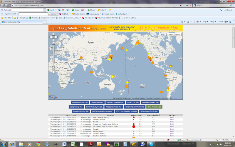
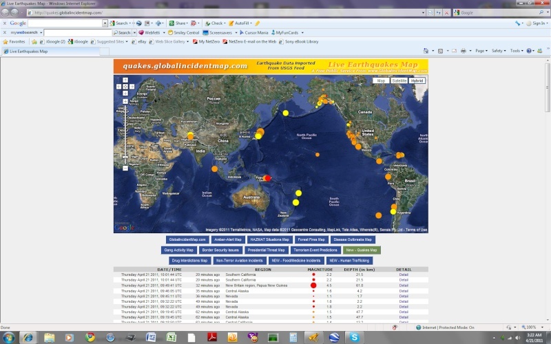
    The Earthquake/Seismic Activity Log - Page 5 Untitl17

    MAP 4.5 2011/04/21 09:49:41 -5.594 151.955 61.8 NEW BRITAIN REGION, PAPUA NEW GUINEA
    MAP 4.5 2011/04/21 09:18:07 12.451 -88.898 83.4 OFFSHORE EL SALVADOR
    MAP 2.7 2011/04/21 08:31:15 18.697 -66.600 74.6 PUERTO RICO REGION
    MAP 5.3 2011/04/21 08:18:15 38.332 142.207 27.8 NEAR THE EAST COAST OF HONSHU, JAPAN
    MAP 3.3 2011/04/21 07:11:40 19.466 -66.336 64.3 PUERTO RICO REGION
    MAP 3.2 2011/04/21 07:09:54 17.748 -68.410 107.3 DOMINICAN REPUBLIC REGION
    MAP 4.5 2011/04/21 07:01:12 38.897 142.967 22.3 NEAR THE EAST COAST OF HONSHU, JAPAN
    MAP 2.5 2011/04/21 06:56:34 32.360 -115.556 0.3 BAJA CALIFORNIA, MEXICO
    MAP 2.9 2011/04/21 05:39:21 32.357 -115.544 7.2 BAJA CALIFORNIA, MEXICO
    MAP 2.8 2011/04/21 04:52:29 32.346 -115.507 3.3 BAJA CALIFORNIA, MEXICO
    MAP 3.1 2011/04/21 04:47:20 32.547 -116.028 7.6 BAJA CALIFORNIA, MEXICO
    MAP 3.5 2011/04/21 04:46:10 32.354 -115.548 8.1 BAJA CALIFORNIA, MEXICO
    MAP 2.6 2011/04/21 04:45:15 32.390 -115.565 0.1 BAJA CALIFORNIA, MEXICO
    MAP 3.6 2011/04/21 04:39:24 32.380 -115.555 3.1 BAJA CALIFORNIA, MEXICO
    MAP 3.3 2011/04/21 04:38:33 32.366 -115.552 4.4 BAJA CALIFORNIA, MEXICO
    MAP 3.8 2011/04/21 04:25:05 31.117 -115.843 0.0 BAJA CALIFORNIA, MEXICO
    MAP 4.0 2011/04/21 04:11:16 32.365 -115.550 5.3 BAJA CALIFORNIA, MEXICO
    MAP 2.9 2011/04/21 03:50:32 32.372 -115.556 0.2 BAJA CALIFORNIA, MEXICO
    MAP 2.7 2011/04/21 03:46:51 62.038 -152.174 2.0 CENTRAL ALASKA
    MAP 4.4 2011/04/21 03:42:43 36.060 69.028 34.1 HINDU KUSH REGION, AFGHANISTAN
    MAP 2.9 2011/04/21 03:13:37 34.074 -117.271 17.1 GREATER LOS ANGELES AREA, CALIFORNIA
    MAP 5.0 2011/04/21 03:08:41 37.286 142.337 44.3 OFF THE EAST COAST OF HONSHU, JAPAN
    MAP 6.0 2011/04/21 01:54:41 40.306 143.629 7.0 OFF THE EAST COAST OF HONSHU, JAPAN
    MAP 5.8 2011/04/21 00:39:05 40.498 143.479 15.0 OFF THE EAST COAST OF HONSHU, JAPAN
    HigherLove
    HigherLove


    Posts : 2357
    Join date : 2011-01-27
    Age : 59

    The Earthquake/Seismic Activity Log - Page 5 Empty Re: The Earthquake/Seismic Activity Log

    Post  HigherLove Thu Apr 21, 2011 6:55 am

    Magnitude
    4.6
    Date-Time
    Thursday, April 21, 2011 at 10:53:08 UTC
    Thursday, April 21, 2011 at 06:53:08 PM at epicenter
    Time of Earthquake in other Time Zones
    Location
    8.932°N, 126.700°E
    Depth
    43.5 km (27.0 miles)
    Region
    MINDANAO, PHILIPPINES
    Distances
    73 km (45 miles) NNE of Hinatuan, Mindanao, Philippines
    127 km (78 miles) E of Butuan, Mindanao, Philippines
    876 km (544 miles) WNW of KOROR, Palau
    884 km (549 miles) SE of MANILA, Philippines
    Location Uncertainty
    horizontal +/- 29.2 km (18.1 miles); depth +/- 12.2 km (7.6 miles)
    Parameters
    NST= 22, Nph= 27, Dmin=240.5 km, Rmss=0.76 sec, Gp=144°,
    M-type=body wave magnitude (Mb), Version=2
    Source
    USGS NEIC (WDCS-D)
    Event ID
    usc0002w83
    HigherLove
    HigherLove


    Posts : 2357
    Join date : 2011-01-27
    Age : 59

    The Earthquake/Seismic Activity Log - Page 5 Empty Re: The Earthquake/Seismic Activity Log

    Post  HigherLove Thu Apr 21, 2011 10:34 am

    I am looking for maps of fault lines in Afghanistan, Pakistan, and Turkey...to name a few. Afghanistan has had a few quakes this week. In the meantime, here is a link that some might enjoy:

    The Worldwide Eathquake Locator: http://tsunami.geo.ed.ac.uk/local-bin/quakes/mapscript/home.pl


    4.6
    Datr-Time
    Thursday, April 21, 2011 at 14:18:31 UTC
    Thursday, April 21, 2011 at 06:48:31 PM at epicenter
    Time of Earthquake in other Time Zones
    Location
    36.467°N, 70.587°E
    Depth
    143.2 km (89.0 miles)
    Region
    HINDU KUSH REGION, AFGHANISTAN
    Distances
    71 km (44 miles) S of Faizabad, Afghanistan
    133 km (82 miles) WNW of Chitral, Pakistan
    142 km (88 miles) SW of Khorugh, Tajikistan
    251 km (155 miles) NNE of KABUL, Afghanistan
    Location Uncertainty
    horizontal +/- 19.9 km (12.4 miles); depth +/- 13.9 km (8.6 miles)
    Parameters
    NST= 51, Nph= 51, Dmin=256 km, Rmss=0.49 sec, Gp= 94°,
    M-type=body wave magnitude (Mb), Version=5
    Source

    USGS NEIC (WDCS-D)
    Event ID

    usc0002w9z
    HigherLove
    HigherLove


    Posts : 2357
    Join date : 2011-01-27
    Age : 59

    The Earthquake/Seismic Activity Log - Page 5 Empty Re: The Earthquake/Seismic Activity Log

    Post  HigherLove Thu Apr 21, 2011 9:24 pm

    Again: Gorda, de fuca, pacific, north american -- terminus of cascadia subduction zone south, and terminus of san andreas, north.

    The Earthquake/Seismic Activity Log - Page 5 37_47_10

    MAP ? 2011/04/22 02:20:28 38.836 -122.832 2.4 5 km ( 3 mi) NNW of The Geysers, CA
    MAP 3.4 2011/04/22 01:32:14 40.810 -123.960 24.2 8 km ( 5 mi) SSE of Blue Lake, CA
    MAP 1.0 2011/04/21 23:29:03 38.789 -122.745 1.8 5 km ( 3 mi) WNW of Anderson Springs, CA
    MAP 1.7 2011/04/21 22:47:34 38.816 -122.792 3.5 2 km ( 1 mi) NNE of The Geysers, CA
    MAP 1.1 2011/04/21 18:14:31 38.833 -122.778 2.3 5 km ( 3 mi) NNE of The Geysers, CA
    MAP 1.5 2011/04/21 17:47:48 37.321 -122.105 0.0 5 km ( 3 mi) S of Los Altos, CA
    MAP 1.6 2011/04/21 17:23:06 38.833 -122.774 2.8 4 km ( 3 mi) W of Cobb, CA
    MAP 1.1 2011/04/21 16:06:51 37.607 -122.453 12.1 3 km ( 2 mi) SW of San Bruno, CA
    MAP 1.1 2011/04/21 15:49:13 38.801 -122.799 3.1 1 km ( 0 mi) ENE of The Geysers, CA
    MAP 2.0 2011/04/21 14:33:25 40.593 -124.329 19.8 6 km ( 4 mi) WNW of Ferndale, CA
    MAP 1.2 2011/04/21 14:03:09 38.762 -122.742 2.1 5 km ( 3 mi) WSW of Anderson Springs, CA
    MAP 1.6 2011/04/21 11:52:03 40.413 -124.305 18.8 10 km ( 6 mi) N of Petrolia, CA
    MAP 1.2 2011/04/21 10:15:12 46.377 -122.363 21.3 19 km ( 12 mi) SSE of Mossyrock, WA
    HigherLove
    HigherLove


    Posts : 2357
    Join date : 2011-01-27
    Age : 59

    The Earthquake/Seismic Activity Log - Page 5 Empty Re: The Earthquake/Seismic Activity Log

    Post  HigherLove Thu Apr 21, 2011 9:34 pm

    This is where I took pics of a pyramid like mountain (Blue Lakes) this morning (actually, there are many, and I saw them for the first time, today). Unreal. (Note: not the same blue lakes, but same name and still close by).

    Anyhow, the Oregon quake does not show up on the smaller map, but things are going on there, also. The cascadia awakens.

    Magnitude
    3.4
    Date-Time
    Friday, April 22, 2011 at 01:32:14 UTC
    Thursday, April 21, 2011 at 06:32:14 PM at epicenter
    Time of Earthquake in other Time Zones
    Location
    40.810°N, 123.960°W
    Depth
    24.2 km (15.0 miles)
    Region
    NORTHERN CALIFORNIA
    Distances
    8 km (5 miles) SSE (163°) from Blue Lake, CA
    12 km (8 miles) SE (124°) from Arcata, CA
    14 km (9 miles) E (81°) from Myrtletown, CA
    17 km (11 miles) E (83°) from Eureka, CA
    329 km (204 miles) NW (320°) from Sacramento, CA
    Location Uncertainty
    horizontal +/- 0.4 km (0.2 miles); depth +/- 0.7 km (0.4 miles)
    Parameters
    Nph= 20, Dmin=6 km, Rmss=0.13 sec, Gp= 76°,
    M-type=local magnitude (ML), Version=2
    Source
    California Integrated Seismic Net:
    USGS Caltech CGS UCB UCSD UNR
    Event ID
    nc71562581
    HigherLove
    HigherLove


    Posts : 2357
    Join date : 2011-01-27
    Age : 59

    The Earthquake/Seismic Activity Log - Page 5 Empty Re: The Earthquake/Seismic Activity Log

    Post  HigherLove Thu Apr 21, 2011 9:56 pm

    Magnitude
    1.8
    Date-Time
    Friday, April 22, 2011 at 02:47:39 UTC
    Thursday, April 21, 2011 at 07:47:39 PM at epicenter
    Location
    46.213°N, 122.183°W
    Depth
    0 km (~0 mile) set by location program
    Region
    MOUNT ST. HELENS AREA, WASHINGTON
    Distances
    1 km (1 miles) N (350°) from Mount St. Helens Volcano, WA
    39 km (24 miles) S (169°) from Morton, WA
    41 km (25 miles) NNE (32°) from Amboy, WA
    60 km (37 miles) E (82°) from Longview, WA
    72 km (45 miles) NNE (27°) from Vancouver, WA
    Location Uncertainty
    horizontal +/- 0.3 km (0.2 miles); depth fixed by location program
    Parameters
    NST= 11, Nph= 11, Dmin=0 km, Rmss=0.42 sec, Gp= 76°,
    M-type=duration magnitude (Md), Version=0
    Source
    Pacific Northwest Seismograph Network
    Event ID
    uw04220247
    HigherLove
    HigherLove


    Posts : 2357
    Join date : 2011-01-27
    Age : 59

    The Earthquake/Seismic Activity Log - Page 5 Empty Re: The Earthquake/Seismic Activity Log

    Post  HigherLove Thu Apr 21, 2011 10:29 pm

    Magnitude
    4.7
    Date-Time
    Friday, April 22, 2011 at 02:57:38 UTC
    Thursday, April 21, 2011 at 10:57:38 PM at epicenter
    Location
    34.684°S, 71.438°W
    Depth
    47.6 km (29.6 miles)
    Region
    LIBERTADOR O'HIGGINS, CHILE
    Distances
    90 km (56 miles) NNE (14°) from Talca, Chile
    150 km (93 miles) SSW (208°) from SANTIAGO, Chile
    179 km (111 miles) S (173°) from Valparaiso, Chile
    Location Uncertainty
    horizontal +/- 28.7 km (17.8 miles); depth +/- 9.2 km (5.7 miles)
    Parameters
    NST= 47, Nph= 54, Dmin=193.7 km, Rmss=0.79 sec, Gp=140°,
    M-type=body wave magnitude (Mb), Version=4
    Source
    U.S. Geological Survey, National Earthquake Information Center:
    World Data Center for Seismology, Denver
    Event ID
    usc0002wud
    HigherLove
    HigherLove


    Posts : 2357
    Join date : 2011-01-27
    Age : 59

    The Earthquake/Seismic Activity Log - Page 5 Empty Re: The Earthquake/Seismic Activity Log

    Post  HigherLove Fri Apr 22, 2011 9:21 am

    Good morning Carol -- all seems to have gone silent on the western front. Any updates on harmonics?


    Last edited by HigherLove on Fri Apr 22, 2011 9:26 am; edited 1 time in total (Reason for editing : rephrase; I need to add a link to this thread...where be ye o' linky link?)
    HigherLove
    HigherLove


    Posts : 2357
    Join date : 2011-01-27
    Age : 59

    The Earthquake/Seismic Activity Log - Page 5 Empty Re: The Earthquake/Seismic Activity Log

    Post  HigherLove Fri Apr 22, 2011 9:34 am

    HigherLove
    HigherLove


    Posts : 2357
    Join date : 2011-01-27
    Age : 59

    The Earthquake/Seismic Activity Log - Page 5 Empty Re: The Earthquake/Seismic Activity Log

    Post  HigherLove Fri Apr 22, 2011 9:41 am

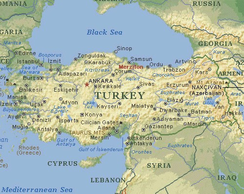
    Turkey is past due, and their big quakes tend to travel east to west, leaving Istanbul in the danger zone.

    http://en.wikipedia.org/wiki/Geology_of_Turkey

    The Earthquake/Seismic Activity Log - Page 5 Turkey10


    The Earthquake/Seismic Activity Log - Page 5 Map-of11


    The Earthquake/Seismic Activity Log - Page 5 Turkey11
    HigherLove
    HigherLove


    Posts : 2357
    Join date : 2011-01-27
    Age : 59

    The Earthquake/Seismic Activity Log - Page 5 Empty Re: The Earthquake/Seismic Activity Log

    Post  HigherLove Fri Apr 22, 2011 12:37 pm

    Magnitude 5.7
    Date-Time Friday, April 22, 2011 at 17:14:48 UTC
    Saturday, April 23, 2011 at 05:14:48 AM at epicenter

    Location 22.703°S, 174.631°W
    Depth 1 km (~0.6 mile) (poorly constrained)
    Region TONGA REGION
    Distances 184 km (114 miles) SSE (160°) from NUKU'ALOFA, Tonga
    456 km (283 miles) S (188°) from Neiafu, Tonga
    2676 km (1663 miles) WSW (253°) from PAPEETE, Tahiti, French Polynesia

    Location Uncertainty horizontal +/- 17.3 km (10.7 miles); depth +/- 6.3 km (3.9 miles)
    Parameters NST=270, Nph=284, Dmin=797 km, Rmss=0.92 sec, Gp= 47°,
    M-type=regional moment magnitude (Mw), Version=5
    Source U.S. Geological Survey, National Earthquake Information Center:
    World Data Center for Seismology, Denver

    Event ID usc0002x1w
    burgundia
    burgundia


    Posts : 5520
    Join date : 2010-04-09
    Location : Poland

    The Earthquake/Seismic Activity Log - Page 5 Empty Re: The Earthquake/Seismic Activity Log

    Post  burgundia Fri Apr 22, 2011 2:11 pm

    5.6 in Fukushima.
    HigherLove
    HigherLove


    Posts : 2357
    Join date : 2011-01-27
    Age : 59

    The Earthquake/Seismic Activity Log - Page 5 Empty Re: The Earthquake/Seismic Activity Log

    Post  HigherLove Fri Apr 22, 2011 3:33 pm

    burgundia wrote:5.6 in Fukushima.

    Thanks!

    I had stopped listing the Japan quakes because there are so many.

    I was thinking that I would stick to the 2.5 U.S. / 4.5 worldwide for others, because that is how the USGS has set it up.

    Other links for Europe and Asia are welcomed, because as has been noted in other threads, not all of their quakes get reported, here.

    Also, I try to take note of clusters of small quakes.

    We have had two quakes of 3.0 or above in Nevada, which has been swarmed by small temblors for several weeks.


    Question

    HigherLove
    HigherLove


    Posts : 2357
    Join date : 2011-01-27
    Age : 59

    The Earthquake/Seismic Activity Log - Page 5 Empty Re: The Earthquake/Seismic Activity Log

    Post  HigherLove Fri Apr 22, 2011 7:33 pm

    Magnitude
    4.9
    Date-Time
    Friday, April 22, 2011 at 23:11:13 UTC
    Saturday, April 23, 2011 at 05:11:13 AM at epicenter
    Location
    45.506°N, 82.613°E
    Depth
    31.6 km (19.6 miles)
    Region
    KAZAKHSTAN-XINJIANG BORDER REGION
    Distances
    180 km (112 miles) W (271°) from Karamay, Xinjiang, China
    211 km (131 miles) NNE (30°) from Yining, Xinjiang, China
    285 km (177 miles) SW (220°) from Zaysan, Kazakhstan
    690 km (429 miles) ENE (62°) from BISHKEK (Frunze), Kyrgyzstan
    Location Uncertainty
    horizontal +/- 13.9 km (8.6 miles); depth +/- 1.3 km (0.8 miles)
    Parameters
    NST=128, Nph=129, Dmin=142.5 km, Rmss=0.43 sec, Gp= 72°,
    M-type=body wave magnitude (Mb), Version=7
    Source
    U.S. Geological Survey, National Earthquake Information Center:
    World Data Center for Seismology, Denver
    Event ID
    usc0002x9z

      Current date/time is Tue Nov 19, 2024 2:21 am