tMoA

Would you like to react to this message? Create an account in a few clicks or log in to continue.
tMoA

~ The only Home on the Web You'll ever need ~

+30
Arrowwind
THEeXchanger
malletzky
LeeEllisMusic
CetaceousOne
MzKarma
greybeard
Brook
lawlessline
MargueriteBee
HigherLove
Jonah
solent
devakas
Micjer
Sanicle
hobbit
Mercuriel
immortalisdolor
giovonni
Floyd
Jenetta
enemyofNWO
lindabaker
JesterTerrestrial
gscraig
AscendingStarseed
mudra
burgundia
Carol
34 posters

    Earth Changes 2013 - Daily Updates

    Carol
    Carol
    Admin
    Admin


    Posts : 31679
    Join date : 2010-04-07
    Location : Hawaii

    Earth Changes 2013 - Daily Updates - Page 2 Empty Re: Earth Changes 2013 - Daily Updates

    Post  Carol Mon Feb 21, 2011 3:46 pm

    Drought in SW China leaves 190,000 without water. Officials in Beijing said the drought could be the worst in a century.
    http://twitter.com/Extinctionp/statuses/39748342787473408


    _________________
    What is life?
    It is the flash of a firefly in the night, the breath of a buffalo in the wintertime. It is the little shadow which runs across the grass and loses itself in the sunset.

    With deepest respect ~ Aloha & Mahalo, Carol
    Carol
    Carol
    Admin
    Admin


    Posts : 31679
    Join date : 2010-04-07
    Location : Hawaii

    Earth Changes 2013 - Daily Updates - Page 2 Empty Re: Earth Changes 2013 - Daily Updates

    Post  Carol Mon Feb 21, 2011 7:19 pm

    New Zealand's Currency Tumbles After 6.3 Earthquake
    The New Zealand dollar dropped after the southern city of Christchurch was affected by an earthquake.

    The currency slid 0.8 percent to 75.80 U.S. cents as of 1:11 p.m. in Wellington, the biggest drop in more than a week, from 76.38 cents yesterday in New York.

    A 6.3 magnitude temblor was recorded off the south island of New Zealand, the U.S. Geological Survey reported.


    _________________
    What is life?
    It is the flash of a firefly in the night, the breath of a buffalo in the wintertime. It is the little shadow which runs across the grass and loses itself in the sunset.

    With deepest respect ~ Aloha & Mahalo, Carol
    JesterTerrestrial
    JesterTerrestrial


    Posts : 1766
    Join date : 2010-04-11
    Location : INNOVATION STATIONS !SCHOOL

    Earth Changes 2013 - Daily Updates - Page 2 Empty Re: Earth Changes 2013 - Daily Updates

    Post  JesterTerrestrial Mon Feb 21, 2011 9:03 pm

    Carol wrote:
    New Zealand's Currency Tumbles After 6.3 Earthquake
    The New Zealand dollar dropped after the southern city of Christchurch was affected by an earthquake.

    The currency slid 0.8 percent to 75.80 U.S. cents as of 1:11 p.m. in Wellington, the biggest drop in more than a week, from 76.38 cents yesterday in New York.

    A 6.3 magnitude temblor was recorded off the south island of New Zealand, the U.S. Geological Survey reported.

    http://www.heraldsun.com.au/news/large-quake-hits-new-zealand/story-e6frf7jo-1226009955454


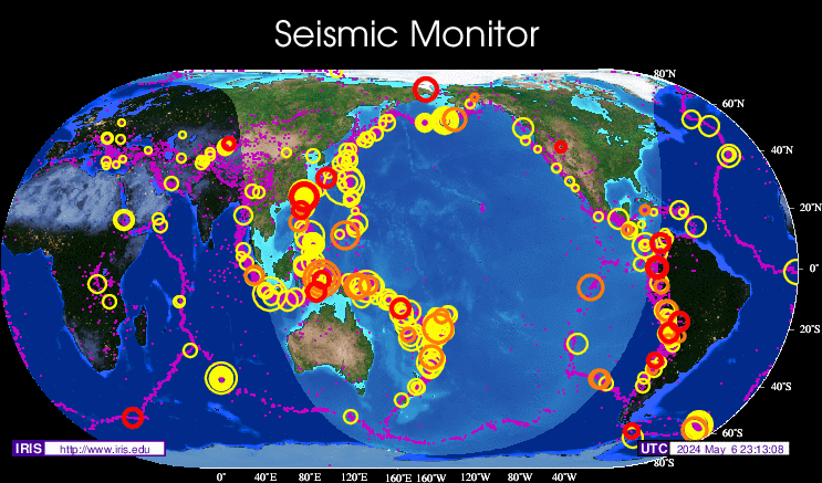
    Latest Earthquakes in the World - Past 7 days

    http://earthquake.usgs.gov/earthquakes/recenteqsww/Quakes/quakes_all.php

    Latest Earthquakes Magnitude 2.5 or Greater in the United States and Adjacent Areas and Magnitude 4.5 or Greater in the Rest of the World - Last 7 days

    This list contains all earthquakes with magnitude greater than 2.5 located by the USGS and contributing networks in the last week (168 hours). Magnitudes 4.5 and above are in bold font. Magnitudes 6 and above are in red. (Some early events may be obscured by later ones on the maps.)

    The most recent earthquakes are at the top of the list. Times are in Coordinated Universal Time (UTC). Click on the word "map" to see a ten-degree tall map displaying the earthquake. Click on an event's "DATE" to get a detailed report.

    DISCLAIMER

    If you cannot see the list, Click here to go to the top of the list.

    Update time = Tue Feb 22 3:00:03 UTC 2011


    [bMAG__UTC DATE-TIME__LAT__LON_DEPTH_Region[/b]


    km
    MAP 2.7 2011/02/22 02:33:03 32.473 -115.645 2.7 BAJA CALIFORNIA, MEXICO
    MAP 5.3 2011/02/22 02:10:25 14.150 120.589 137.0 LUZON, PHILIPPINES
    MAP 5.5 2011/02/22 01:50:29 -43.588 172.734 9.6 SOUTH ISLAND OF NEW ZEALAND
    MAP 5.6 2011/02/22 00:04:18 -43.580 172.798 6.7 SOUTH ISLAND OF NEW ZEALAND
    MAG UTC DATE-TIME
    y/m/d h:m:s LAT
    deg LON
    deg DEPTH
    km Region
    MAP 6.3 2011/02/21 23:51:43 -43.600 172.710 5.0 SOUTH ISLAND OF NEW ZEALAND
    MAP 2.6 2011/02/21 23:23:28 62.784 -149.672 76.6 CENTRAL ALASKA
    MAP 2.6 2011/02/21 23:10:21 35.246 -92.389 4.8 ARKANSAS
    MAP 4.7 2011/02/21 21:59:35 -21.069 135.432 9.8 NORTHERN TERRITORY, AUSTRALIA
    MAP 2.5 2011/02/21 18:17:46 33.071 -116.088 11.0 SOUTHERN CALIFORNIA
    MAP 2.5 2011/02/21 17:32:00 35.251 -92.364 7.2 ARKANSAS
    MAP 2.6 2011/02/21 16:21:58 35.253 -92.388 6.3 ARKANSAS
    MAP 3.4 2011/02/21 16:17:33 35.265 -92.385 6.0 ARKANSAS
    MAP 2.5 2011/02/21 15:13:34 59.284 -153.618 100.0 SOUTHERN ALASKA
    MAP 4.4 2011/02/21 14:29:15 13.400 -90.675 78.0 OFFSHORE GUATEMALA
    MAP 2.5 2011/02/21 14:24:36 38.132 -119.614 5.0 CENTRAL CALIFORNIA
    MAP 4.9 2011/02/21 13:24:06 38.300 143.259 35.0 OFF THE EAST COAST OF HONSHU, JAPAN
    MAP 5.1 2011/02/21 12:26:34 -10.180 161.348 79.7 SOLOMON ISLANDS
    MAP 2.6 2011/02/21 11:09:18 33.603 -117.677 9.3 GREATER LOS ANGELES AREA, CALIFORNIA
    MAP 2.7 2011/02/21 11:08:56 62.295 -150.875 76.8 CENTRAL ALASKA
    MAP 2.7 2011/02/21 11:05:59 19.971 -154.971 7.0 HAWAII REGION, HAWAII
    MAP 2.5 2011/02/21 10:59:15 35.262 -92.376 6.6 ARKANSAS
    MAP 6.4 2011/02/21 10:57:53 -26.083 178.439 561.8 SOUTH OF THE FIJI ISLANDS
    MAP 5.0 2011/02/21 10:05:19 -4.599 152.387 99.1 NEW BRITAIN REGION, PAPUA NEW GUINEA
    MAP 2.8 2011/02/21 09:13:37 59.563 -150.310 20.3 KENAI PENINSULA, ALASKA
    MAP 3.2 2011/02/21 09:04:18 35.791 -120.347 9.9 CENTRAL CALIFORNIA
    MAP 5.6 2011/02/21 06:58:36 -27.205 -64.764 10.6 SANTIAGO DEL ESTERO, ARGENTINA
    MAP 5.0 2011/02/21 06:46:10 33.865 135.362 50.9 NEAR S. COAST OF WESTERN HONSHU, JAPAN
    MAP 2.6 2011/02/21 05:58:49 34.026 -117.222 14.6 GREATER LOS ANGELES AREA, CALIFORNIA
    MAP 2.6 2011/02/21 05:42:46 35.267 -92.356 4.2 ARKANSAS
    MAP 5.4 2011/02/21 05:38:51 -45.733 -72.321 35.2 AISEN, CHILE
    MAP 4.6 2011/02/21 04:57:56 -22.889 -68.721 115.9 ANTOFAGASTA, CHILE
    MAP 3.2 2011/02/21 04:47:24 18.679 -64.632 46.5 VIRGIN ISLANDS REGION
    MAP 2.9 2011/02/21 04:27:56 35.265 -92.355 4.5 ARKANSAS
    MAP 2.5 2011/02/21 03:43:00 32.152 -115.220 12.1 BAJA CALIFORNIA, MEXICO
    MAP 2.6 2011/02/21 02:30:53 19.595 -155.892 31.0 ISLAND OF HAWAII, HAWAII
    MAP 3.2 2011/02/21 01:56:20 51.700 177.826 61.3 RAT ISLANDS, ALEUTIAN ISLANDS, ALASKA
    MAP 4.6 2011/02/21 01:54:38 3.057 127.898 102.7 KEPULAUAN TALAUD, INDONESIA
    MAP 4.7 2011/02/21 01:31:35 10.209 -84.935 58.7 COSTA RICA
    MAP 2.5 2011/02/21 00:25:56 35.325 -118.488 5.9 CENTRAL CALIFORNIA
    MAG UTC DATE-TIME
    y/m/d h:m:s LAT
    deg LON
    deg DEPTH
    km Region
    MAP 4.8 2011/02/20 22:25:49 -27.898 -66.576 151.5 CATAMARCA, ARGENTINA
    MAP 5.9 2011/02/20 21:43:21 55.917 162.142 9.6 NEAR THE EAST COAST OF KAMCHATKA, RUSSIA
    MAP 2.5 2011/02/20 21:37:28 35.257 -92.356 6.1 ARKANSAS
    MAP 2.5 2011/02/20 21:32:02 35.255 -92.343 5.7 ARKANSAS
    MAP 2.9 2011/02/20 21:09:51 52.353 -170.464 27.5 FOX ISLANDS, ALEUTIAN ISLANDS, ALASKA
    MAP 3.0 2011/02/20 21:02:28 19.465 -65.689 25.0 PUERTO RICO REGION
    MAP 4.5 2011/02/20 19:34:41 32.178 -115.159 27.0 BAJA CALIFORNIA, MEXICO
    MAP 2.7 2011/02/20 18:22:05 35.257 -92.351 6.5 ARKANSAS
    MAP 5.1 2011/02/20 17:52:54 -7.918 122.828 230.9 FLORES SEA
    MAP 5.0 2011/02/20 17:37:39 -58.899 -25.667 23.6 SOUTH SANDWICH ISLANDS REGION
    MAP 3.6 2011/02/20 17:05:02 18.866 -64.250 24.0 VIRGIN ISLANDS REGION
    MAP 4.3 2011/02/20 16:48:57 -7.595 127.586 149.6 KEPULAUAN BARAT DAYA, INDONESIA
    MAP 2.7 2011/02/20 16:44:48 37.493 -118.841 9.9 CENTRAL CALIFORNIA
    MAP 2.9 2011/02/20 15:49:08 18.967 -67.477 20.0 PUERTO RICO REGION
    MAP 2.5 2011/02/20 15:37:32 17.849 -67.061 36.0 PUERTO RICO REGION
    MAP 3.7 2011/02/20 15:15:00 35.260 -92.375 5.2 ARKANSAS
    MAP 4.1 2011/02/20 15:11:30 37.847 19.958 10.0 IONIAN SEA
    MAP 5.3 2011/02/20 14:32:25 1.360 97.201 40.3 NIAS REGION, INDONESIA
    MAP 4.2 2011/02/20 13:41:15 -10.582 120.148 50.3 SUMBA REGION, INDONESIA
    MAP 2.5 2011/02/20 13:04:38 52.614 -169.084 13.6 FOX ISLANDS, ALEUTIAN ISLANDS, ALASKA
    MAP 2.6 2011/02/20 12:47:23 54.519 -161.569 23.1 ALASKA PENINSULA
    MAP 4.2 2011/02/20 11:22:16 35.430 51.830 7.0 NORTHERN IRAN
    MAP 5.1 2011/02/20 09:51:06 1.287 126.336 29.5 MOLUCCA SEA
    MAP 5.2 2011/02/20 09:17:14 -7.338 155.032 51.8 SOLOMON ISLANDS
    MAP 5.1 2011/02/20 09:09:58 13.675 51.634 10.1 GULF OF ADEN
    MAP 2.5 2011/02/20 04:55:33 52.597 -168.960 6.8 FOX ISLANDS, ALEUTIAN ISLANDS, ALASKA
    MAP 2.8 2011/02/20 02:30:31 33.690 -116.737 19.3 SOUTHERN CALIFORNIA
    MAP 4.5 2011/02/20 00:58:20 13.653 -90.588 74.1 OFFSHORE GUATEMALA
    MAG UTC DATE-TIME
    y/m/d h:m:s LAT
    deg LON
    deg DEPTH
    km Region
    MAP 2.9 2011/02/19 23:36:02 18.669 -67.084 83.8 PUERTO RICO REGION
    MAP 3.4 2011/02/19 23:04:58 35.268 -92.374 6.7 ARKANSAS
    MAP 3.2 2011/02/19 22:57:13 34.310 -118.705 5.3 GREATER LOS ANGELES AREA, CALIFORNIA
    MAP 2.5 2011/02/19 21:59:31 46.278 -122.220 3.2 MOUNT ST. HELENS AREA, WASHINGTON
    MAP 2.5 2011/02/19 21:39:53 51.834 -176.215 64.8 ANDREANOF ISLANDS, ALEUTIAN IS., ALASKA
    MAP 2.7 2011/02/19 21:22:50 54.477 -163.973 93.4 UNIMAK ISLAND REGION, ALASKA
    MAP 2.7 2011/02/19 20:32:50 18.959 -67.325 7.5 PUERTO RICO REGION
    MAP 2.5 2011/02/19 18:10:49 53.107 -166.992 27.5 FOX ISLANDS, ALEUTIAN ISLANDS, ALASKA
    MAP 3.3 2011/02/19 17:35:00 18.959 -64.853 11.8 VIRGIN ISLANDS REGION
    MAP 2.9 2011/02/19 17:04:58 19.327 -155.125 8.4 ISLAND OF HAWAII, HAWAII
    MAP 2.7 2011/02/19 15:19:05 52.658 -169.185 17.9 FOX ISLANDS, ALEUTIAN ISLANDS, ALASKA
    MAP 4.8 2011/02/19 14:57:12 13.527 -90.570 71.5 OFFSHORE GUATEMALA
    MAP 2.9 2011/02/19 14:42:25 63.496 -147.781 4.9 CENTRAL ALASKA
    MAP 4.8 2011/02/19 14:22:03 26.535 143.784 38.6 BONIN ISLANDS, JAPAN REGION
    MAP 2.6 2011/02/19 11:23:44 59.345 -153.482 109.3 SOUTHERN ALASKA
    MAP 2.7 2011/02/19 10:47:29 52.183 -174.498 174.8 ANDREANOF ISLANDS, ALEUTIAN IS., ALASKA
    MAP 4.4 2011/02/19 10:31:18 14.569 -91.938 79.4 GUATEMALA
    MAP 2.5 2011/02/19 10:22:20 52.708 -169.324 4.4 FOX ISLANDS, ALEUTIAN ISLANDS, ALASKA
    MAP 3.3 2011/02/19 10:07:07 18.107 -68.571 83.0 DOMINICAN REPUBLIC REGION
    MAP 4.8 2011/02/19 09:54:48 18.272 146.603 52.7 PAGAN REGION, NORTHERN MARIANA ISLANDS
    MAP 2.5 2011/02/19 09:05:02 57.077 -155.218 36.2 ALASKA PENINSULA
    MAP 3.6 2011/02/19 08:55:55 62.438 -151.202 81.1 CENTRAL ALASKA
    MAP 4.7 2011/02/19 08:55:21 -16.878 -177.395 397.1 FIJI REGION
    MAP 3.1 2011/02/19 08:43:08 52.582 -169.154 15.5 FOX ISLANDS, ALEUTIAN ISLANDS, ALASKA
    MAP 4.3 2011/02/19 07:40:22 -12.000 -77.487 35.0 NEAR THE COAST OF CENTRAL PERU
    MAP 4.5 2011/02/19 07:22:24 -21.910 -68.489 97.0 ANTOFAGASTA, CHILE
    MAP 5.3 2011/02/19 06:26:33 -33.963 -71.990 10.5 OFFSHORE LIBERTADOR O'HIGGINS, CHILE
    MAP 2.5 2011/02/19 04:51:37 35.269 -92.364 6.1 ARKANSAS
    MAP 4.7 2011/02/19 03:59:11 52.081 178.188 146.0 RAT ISLANDS, ALEUTIAN ISLANDS, ALASKA
    MAP 4.9 2011/02/19 03:12:50 3.238 126.554 76.2 KEPULAUAN TALAUD, INDONESIA
    MAP 2.5 2011/02/19 02:56:00 36.684 -121.310 4.1 CENTRAL CALIFORNIA
    MAP 2.6 2011/02/19 00:53:10 32.615 -115.732 5.1 BAJA CALIFORNIA, MEXICO
    MAG UTC DATE-TIME
    y/m/d h:m:s LAT
    deg LON
    deg DEPTH
    km Region
    MAP 4.8 2011/02/18 23:54:10 -34.895 -70.109 41.3 MENDOZA, ARGENTINA
    MAP 2.7 2011/02/18 23:47:37 55.134 -157.053 8.5 ALASKA PENINSULA
    MAP 3.5 2011/02/18 23:15:34 30.180 -87.848 5.0 OFFSHORE ALABAMA
    MAP 5.3 2011/02/18 23:12:05 1.906 97.861 44.2 NIAS REGION, INDONESIA
    MAP 3.0 2011/02/18 22:34:16 19.352 -155.335 33.2 ISLAND OF HAWAII, HAWAII
    MAP 3.5 2011/02/18 22:15:28 51.547 178.960 75.0 RAT ISLANDS, ALEUTIAN ISLANDS, ALASKA
    MAP 3.3 2011/02/18 22:12:58 53.508 -163.578 29.1 UNIMAK ISLAND REGION, ALASKA
    MAP 5.4 2011/02/18 20:20:31 44.807 150.099 40.7 EAST OF THE KURIL ISLANDS
    MAP 4.4 2011/02/18 18:28:22 18.329 145.402 375.8 PAGAN REGION, NORTHERN MARIANA ISLANDS
    MAP 3.8 2011/02/18 17:52:04 32.100 -115.101 10.0 BAJA CALIFORNIA, MEXICO
    MAP 3.9 2011/02/18 17:50:55 32.020 -115.040 10.0 BAJA CALIFORNIA, MEXICO
    MAP 5.1 2011/02/18 17:47:36 32.047 -115.062 15.0 BAJA CALIFORNIA, MEXICO
    MAP 2.8 2011/02/18 17:43:13 32.853 -116.257 11.1 SOUTHERN CALIFORNIA
    MAP 5.2 2011/02/18 17:01:04 -33.891 -71.906 45.0 OFFSHORE VALPARAISO, CHILE
    MAP 3.2 2011/02/18 16:39:26 36.684 -121.309 4.5 CENTRAL CALIFORNIA
    MAP 2.9 2011/02/18 16:25:30 59.998 -152.585 100.9 SOUTHERN ALASKA
    MAP 2.5 2011/02/18 16:04:24 35.244 -92.358 7.0 ARKANSAS
    MAP 2.6 2011/02/18 14:32:36 61.041 -147.714 7.9 SOUTHERN ALASKA
    MAP 3.0 2011/02/18 14:09:01 56.754 -156.412 77.5 ALASKA PENINSULA
    MAP 2.9 2011/02/18 13:29:03 62.905 -149.540 79.4 CENTRAL ALASKA
    MAP 2.6 2011/02/18 13:07:32 19.333 -155.115 8.8 ISLAND OF HAWAII, HAWAII
    MAP 2.5 2011/02/18 13:06:51 35.263 -92.361 6.6 ARKANSAS
    MAP 2.8 2011/02/18 13:00:50 31.578 -115.848 2.2 BAJA CALIFORNIA, MEXICO
    MAP 3.2 2011/02/18 12:18:24 35.269 -92.369 6.0 ARKANSAS
    MAP 2.7 2011/02/18 11:53:34 35.259 -92.346 7.1 ARKANSAS
    MAP 2.5 2011/02/18 09:53:29 67.975 -156.088 10.0 NORTHERN ALASKA
    MAP 4.8 2011/02/18 08:59:33 -18.969 -173.927 29.8 TONGA
    MAP 2.7 2011/02/18 08:57:37 52.965 -170.395 131.3 FOX ISLANDS, ALEUTIAN ISLANDS, ALASKA
    MAP 4.1 2011/02/18 08:13:35 35.271 -92.377 6.3 ARKANSAS
    MAP 4.5 2011/02/18 08:10:30 -3.545 126.663 42.4 BURU, INDONESIA
    MAP 4.9 2011/02/18 08:03:16 26.569 143.688 10.0 BONIN ISLANDS, JAPAN REGION
    MAP 2.6 2011/02/18 07:23:45 51.414 -178.726 17.5 ANDREANOF ISLANDS, ALEUTIAN IS., ALASKA
    MAP 2.5 2011/02/18 07:08:15 53.233 -166.830 41.8 FOX ISLANDS, ALEUTIAN ISLANDS, ALASKA
    MAP 2.5 2011/02/18 06:10:33 35.255 -92.355 7.2 ARKANSAS
    MAP 2.5 2011/02/18 05:02:03 35.264 -92.361 5.6 ARKANSAS
    MAP 3.9 2011/02/18 04:59:51 35.257 -92.370 5.1 ARKANSAS
    MAP 2.6 2011/02/18 04:42:25 35.255 -92.355 7.1 ARKANSAS
    MAP 2.6 2011/02/18 04:24:19 35.258 -92.355 7.4 ARKANSAS
    MAP 5.3 2011/02/18 04:23:18 -4.665 153.140 54.1 NEW IRELAND REGION, PAPUA NEW GUINEA
    MAP 2.9 2011/02/18 02:30:14 35.261 -92.375 7.0 ARKANSAS
    MAP 2.5 2011/02/18 01:24:30 35.254 -92.339 5.9 ARKANSAS
    MAP 4.6 2011/02/18 01:21:52 26.557 143.506 10.3 BONIN ISLANDS, JAPAN REGION
    MAP 2.5 2011/02/18 01:00:54 61.507 -149.844 42.1 SOUTHERN ALASKA
    MAG UTC DATE-TIME
    y/m/d h:m:s LAT
    deg LON
    deg DEPTH
    km Region
    MAP 4.8 2011/02/17 23:26:36 36.769 141.126 46.5 NEAR THE EAST COAST OF HONSHU, JAPAN
    MAP 4.8 2011/02/17 22:54:28 -2.800 128.250 51.9 CERAM SEA, INDONESIA
    MAP 4.7 2011/02/17 22:20:54 16.520 120.410 52.8 LUZON, PHILIPPINES
    MAP 2.7 2011/02/17 22:06:45 35.265 -92.365 6.0 ARKANSAS
    MAP 2.9 2011/02/17 21:02:18 54.208 -162.923 25.6 ALASKA PENINSULA
    MAP 5.8 2011/02/17 20:51:07 -14.228 166.366 34.4 VANUATU
    MAP 2.5 2011/02/17 18:19:09 35.262 -92.357 5.2 ARKANSAS
    MAP 3.3 2011/02/17 18:13:19 32.231 -115.309 3.6 BAJA CALIFORNIA, MEXICO
    MAP 2.5 2011/02/17 18:09:56 52.096 -175.595 200.6 ANDREANOF ISLANDS, ALEUTIAN IS., ALASKA
    MAP 2.8 2011/02/17 14:58:14 35.267 -92.367 5.9 ARKANSAS
    MAP 3.1 2011/02/17 11:32:49 62.735 -148.295 53.3 CENTRAL ALASKA
    MAP 2.5 2011/02/17 11:10:40 51.761 -178.820 86.8 ANDREANOF ISLANDS, ALEUTIAN IS., ALASKA
    MAP 2.5 2011/02/17 10:55:05 46.279 -122.215 6.3 MOUNT ST. HELENS AREA, WASHINGTON
    MAP 3.8 2011/02/17 10:49:49 35.276 -92.361 6.5 ARKANSAS
    MAP 3.2 2011/02/17 06:19:01 19.365 -65.786 65.5 PUERTO RICO REGION
    MAP 2.6 2011/02/17 06:02:44 35.263 -92.348 6.2 ARKANSAS
    MAP 2.9 2011/02/17 05:36:58 55.325 -156.886 4.8 SOUTH OF ALASKA
    MAP 2.6 2011/02/17 04:09:40 35.267 -92.347 6.4 ARKANSAS
    MAP 2.8 2011/02/17 03:39:10 53.128 -166.762 25.6 FOX ISLANDS, ALEUTIAN ISLANDS, ALASKA
    MAP 2.5 2011/02/17 02:53:26 35.266 -92.361 6.4 ARKANSAS
    MAP 2.5 2011/02/17 02:44:16 35.269 -92.368 4.9 ARKANSAS
    MAP 2.6 2011/02/17 02:28:36 61.797 -151.903 108.3 SOUTHERN ALASKA
    MAP 2.5 2011/02/17 01:36:45 35.279 -92.352 6.1 ARKANSAS
    MAP 2.5 2011/02/17 00:57:19 59.935 -152.957 96.0 SOUTHERN ALASKA
    MAP 3.2 2011/02/17 00:55:42 18.244 -68.300 89.5 MONA PASSAGE, DOMINICAN REPUBLIC
    MAP 2.9 2011/02/17 00:43:06 52.727 -169.108 0.7 FOX ISLANDS, ALEUTIAN ISLANDS, ALASKA
    MAP 3.2 2011/02/17 00:41:31 52.671 -169.290 3.1 FOX ISLANDS, ALEUTIAN ISLANDS, ALASKA
    MAP 4.2 2011/02/17 00:04:44 -0.306 -78.476 12.0 ECUADOR
    MAG UTC DATE-TIME
    y/m/d h:m:s LAT
    deg LON
    deg DEPTH
    km Region
    MAP 5.6 2011/02/16 23:45:10 25.918 128.294 1.0 RYUKYU ISLANDS, JAPAN
    MAP 3.9 2011/02/16 23:41:24 17.828 -67.044 11.6 PUERTO RICO REGION
    MAP 2.5 2011/02/16 23:05:54 35.262 -92.361 5.1 ARKANSAS
    MAP 3.2 2011/02/16 22:29:59 17.834 -67.034 10.0 PUERTO RICO REGION
    MAP 3.5 2011/02/16 21:46:17 35.270 -92.361 6.6 ARKANSAS
    MAP 4.7 2011/02/16 21:34:20 -19.947 -177.615 377.8 FIJI REGION
    MAP 3.2 2011/02/16 21:19:10 18.165 -68.064 88.8 MONA PASSAGE, DOMINICAN REPUBLIC
    MAP 3.6 2011/02/16 18:12:55 62.990 -149.689 81.6 CENTRAL ALASKA
    MAP 2.9 2011/02/16 17:07:02 35.274 -92.374 5.9 ARKANSAS
    MAP 4.5 2011/02/16 16:39:52 -2.497 121.673 42.1 SULAWESI, INDONESIA
    MAP 5.0 2011/02/16 15:56:00 -20.177 -177.610 528.5 FIJI REGION
    MAP 2.8 2011/02/16 15:52:36 35.278 -92.371 6.2 ARKANSAS
    MAP 2.7 2011/02/16 14:39:08 35.276 -92.369 6.0 ARKANSAS
    MAP 2.5 2011/02/16 13:43:28 60.105 -153.623 10.1 SOUTHERN ALASKA
    MAP 2.6 2011/02/16 10:55:46 32.102 -115.240 5.9 BAJA CALIFORNIA, MEXICO
    MAP 4.7 2011/02/16 10:55:27 10.588 91.780 23.9 ANDAMAN ISLANDS, INDIA REGION
    MAP 2.6 2011/02/16 10:53:14 35.275 -92.374 5.8 ARKANSAS
    MAP 3.2 2011/02/16 10:34:37 19.330 -65.672 94.1 PUERTO RICO REGION
    MAP 2.7 2011/02/16 09:14:58 32.197 -115.280 14.0 BAJA CALIFORNIA, MEXICO
    MAP 4.6 2011/02/16 08:12:45 4.612 126.652 84.6 KEPULAUAN TALAUD, INDONESIA
    MAP 2.7 2011/02/16 04:34:06 32.253 -115.369 6.0 BAJA CALIFORNIA, MEXICO
    MAP 4.3 2011/02/16 02:38:35 13.185 -89.026 79.8 OFFSHORE EL SALVADOR
    MAP 5.0 2011/02/16 02:15:39 -6.130 149.432 55.2 NEW BRITAIN REGION, PAPUA NEW GUINEA
    MAP 2.8 2011/02/16 01:57:29 18.118 -66.677 21.0 PUERTO RICO
    MAP 2.9 2011/02/16 00:29:10 31.157 -115.751 6.0 BAJA CALIFORNIA, MEXICO
    MAG UTC DATE-TIME
    y/m/d h:m:s LAT
    deg LON
    deg DEPTH
    km Region
    MAP 3.0 2011/02/15 23:38:59 38.824 -122.805 3.7 NORTHERN CALIFORNIA
    MAP 2.7 2011/02/15 22:35:23 35.268 -92.373 5.6 ARKANSAS
    MAP 5.2 2011/02/15 21:59:03 -0.090 -17.963 15.4 NORTH OF ASCENSION ISLAND
    MAP 3.0 2011/02/15 21:14:54 52.593 -168.952 2.4 FOX ISLANDS, ALEUTIAN ISLANDS, ALASKA
    MAP 2.9 2011/02/15 20:55:47 33.644 -116.757 14.6 SOUTHERN CALIFORNIA
    MAP 2.6 2011/02/15 20:43:54 51.389 -176.090 25.6 ANDREANOF ISLANDS, ALEUTIAN IS., ALASKA
    MAP 3.6 2011/02/15 20:29:53 19.108 -64.677 99.0 VIRGIN ISLANDS REGION
    MAP 5.2 2011/02/15 19:06:51 38.373 142.774 10.0 NEAR THE EAST COAST OF HONSHU, JAPAN
    MAP 5.2 2011/02/15 19:01:02 38.328 143.144 18.8 OFF THE EAST COAST OF HONSHU, JAPAN
    MAP 4.6 2011/02/15 18:14:10 -6.617 103.607 33.5 SOUTHWEST OF SUMATRA, INDONESIA
    MAP 4.7 2011/02/15 18:13:45 1.796 124.013 314.4 MINAHASA, SULAWESI, INDONESIA
    MAP 4.9 2011/02/15 17:33:26 -6.151 130.586 133.7 BANDA SEA
    MAP 4.8 2011/02/15 17:23:51 25.974 128.289 15.0 RYUKYU ISLANDS, JAPAN
    MAP 2.9 2011/02/15 14:47:41 48.885 -123.494 18.9 VANCOUVER ISLAND, CANADA REGION
    MAP 5.4 2011/02/15 14:12:50 25.895 128.287 4.7 RYUKYU ISLANDS, JAPAN
    MAP 6.1 2011/02/15 13:33:53 -2.513 121.485 14.7 SULAWESI, INDONESIA
    MAP 2.5 2011/02/15 11:43:47 51.443 -176.041 43.7 ANDREANOF ISLANDS, ALEUTIAN IS., ALASKA
    MAP 5.0 2011/02/15 11:04:54 17.400 145.826 172.6 ALAMAGAN REG., NORTHERN MARIANA ISLANDS
    MAP 2.6 2011/02/15 11:02:53 52.632 -169.113 15.3 FOX ISLANDS, ALEUTIAN ISLANDS, ALASKA
    MAP 3.1 2011/02/15 10:56:23 52.611 -169.149 13.1 FOX ISLANDS, ALEUTIAN ISLANDS, ALASKA
    MAP 3.2 2011/02/15 10:53:54 52.680 -169.273 14.9 FOX ISLANDS, ALEUTIAN ISLANDS, ALASKA
    MAP 2.5 2011/02/15 10:20:13 32.091 -115.258 5.8 BAJA CALIFORNIA, MEXICO
    MAP 2.5 2011/02/15 09:52:47 52.620 -168.891 4.8 FOX ISLANDS, ALEUTIAN ISLANDS, ALASKA
    MAP 2.9 2011/02/15 09:47:32 52.557 -169.162 14.4 FOX ISLANDS, ALEUTIAN ISLANDS, ALASKA
    MAP 2.7 2011/02/15 09:46:15 52.558 -169.026 11.9 FOX ISLANDS, ALEUTIAN ISLANDS, ALASKA
    MAP 3.4 2011/02/15 09:29:37 52.597 -169.023 14.8 FOX ISLANDS, ALEUTIAN ISLANDS, ALASKA
    MAP 3.2 2011/02/15 09:29:00 52.583 -169.020 3.7 FOX ISLANDS, ALEUTIAN ISLANDS, ALASKA
    MAP 3.3 2011/02/15 09:24:33 52.526 -169.129 7.0 FOX ISLANDS, ALEUTIAN ISLANDS, ALASKA
    MAP 4.7 2011/02/15 09:18:32 52.861 -169.404 61.4 FOX ISLANDS, ALEUTIAN ISLANDS, ALASKA
    MAP 2.7 2011/02/15 08:27:02 52.611 -168.972 4.0 FOX ISLANDS, ALEUTIAN ISLANDS, ALASKA
    MAP 5.4 2011/02/15 07:18:19 21.135 121.136 35.7 TAIWAN REGION
    MAP 2.5 2011/02/15 05:27:25 60.103 -141.251 2.0 SOUTHERN ALASKA
    JesterTerrestrial
    JesterTerrestrial


    Posts : 1766
    Join date : 2010-04-11
    Location : INNOVATION STATIONS !SCHOOL

    Earth Changes 2013 - Daily Updates - Page 2 Empty Re: Earth Changes 2013 - Daily Updates

    Post  JesterTerrestrial Mon Feb 21, 2011 9:14 pm

    Tuesday Feb 22 Seismic Monitor
    Earth Changes 2013 - Daily Updates - Page 2 Top_legend
    Earth Changes 2013 - Daily Updates - Page 2 TopMap.eveday_big
    AscendingStarseed
    AscendingStarseed


    Posts : 132
    Join date : 2010-11-14
    Age : 63
    Location : Pahoa, Hawaii

    Earth Changes 2013 - Daily Updates - Page 2 Empty Trillion to one: Teenager hit by 30,000mph meteorite

    Post  AscendingStarseed Tue Feb 22, 2011 3:12 am

    by Terrence Aym

    February 19, 2011

    German teenager Gerrit Blank may be the unluckiest person on Earth...or maybe he's the luckiest.

    What some astronomers claim is a "trillion to one chance" has happened again, a meteorite has hit a human being. Although the odds are certainly against anyone being hit—let alone killed—by a meteorite.

    Perhaps a trillion to one is being too optimistic, however, because at least two people have been struck by meteorites in less than 100 years and there may be more cases of such incidents.
    Over the past few thousands of years dozens of documented cases recorded the maiming or killing of many humans. Some of the more verifiable historical cases can be found at "Reported Deaths and Injuries from Meteorite Impact" http://delong.typepad.com/sdj/ 2008/06/reported-deaths.html Other documented near misses are described here: http://www.ketv.com/news/46721 77/detail.html

    Animals too are subject to meteoric injuries and death.

    According to news reports, Blank, who was walking to school, was grazed by a space rock about the size of a pea. That might not sound too sensational until one considers that the "pea" was traveling about 30,000mph.

    The tiny chunk of rock hit his hand before slamming into the ground next to him creating a foot-wide crater. That is the bad luck part of the story.

    The good luck comes with his survival of the incident. Although he suffered an injury—the encounter with the meteorite has left him with a livid three-inch long scar—Blank is really none the worse for wear considering what would have happened had the rock scored a direct hit.

    A meteorite did score a direct hit on an animal. The space rock dubbed "Valera," hit and horribly killed a grazing cow. The animal literally exploded where it stood and was cut almost entirely in half within an instant.

    Other meteorites have been reported to have killed an Egyptian dog, a horse, and other animals.

    The best documented human-meteor encounter before Blank's experience occurred back on November 30, 1954. Ann Hodges of Sylacauga, Alabama was in her living room sleeping on a couch when a grapefruit-sized meteor came smashing through the roof, slammed onto the radio, bounced off it and hit her. She suffered cuts and bruises.

    According to Wikipedia, the "Hodges meteorite"—or Sylacauga meteorite—is displayed at the Alabama Museum of Natural History.

    Blank told the newsmedia during an interview about his experence that "At first I just saw a large ball of light, and then I suddenly felt a pain in my hand. Then a split second after that there was an enormous bang like a crash of thunder."

    The flash and ban startled and disoriented the boy.
    read more:
    http://www.helium.com/items/2095605-teenager-hit-by-30000mph-meteorite
    mudra
    mudra


    Posts : 23207
    Join date : 2010-04-09
    Age : 69
    Location : belgium

    Earth Changes 2013 - Daily Updates - Page 2 Empty Re: Earth Changes 2013 - Daily Updates

    Post  mudra Tue Feb 22, 2011 7:38 am

    February 2011
    New Zealand earthquake: 65 dead in Christchurch


    http://www.bbc.co.uk/news/world-asia-pacific-12533291

    New Zealand's prime minister says at least 65 people have died after a 6.3-magnitude earthquake hit Christchurch.

    John Key said the toll was expected to rise further, adding: "We may be witnessing New Zealand's darkest day."

    The tremor caused widespread damage as it occurred at a shallow depth of 5km (3.1 miles) during lunchtime when Christchurch was at its busiest.

    The mayor of New Zealand's second-biggest city says 120 people have been rescued from the ruins.

    The country's deadliest natural disaster in 80 years struck at 1251 (2351 GMT on Monday), 10km (6.2 miles) south-east of the city.
    Screams from rubble

    The damage is said to be far worse than after the 7.1-magnitude quake on 4 September, which left two people seriously injured but no fatalities.
    Continue reading the main story
    “Start Quote

    We've had friends in town call us and say there are just bodies lying around: lots of dead bodies outside shops just lying there just covered in bricks”

    End Quote Jaydn Katene Christchurch resident

    * Christchurch earthquake: Eyewitness accounts

    The epicentre of that quake, which occurred in the middle of the night, was further away from the city and deeper underground, but it still caused an estimated $3bn (£1.9bn) in damage.

    TV pictures of the aftermath of Tuesday's disaster showed scores of collapsed buildings in the South Island city of nearly 400,000 people.

    Shocked survivors could be seen wandering the rubble-strewn streets, which cracked open as the ground beneath was liquefied by the tremor.

    Police said that the dead included people on two buses which were crushed by falling buildings.

    Helicopters plucked survivors to safety from rooftops, and dumped water on fires.

    Officials said up to 30 people were feared still trapped inside the razed Pyne Gould Guinness building, where screams have been heard from the ruins.

    Trapped under her desk inside the building, Anne Voss told Australia's Channel Seven by mobile phone: "I am hoping they will get me out soon because I have been here so long. And it's dark. And it's horrible."

    Asked whether she was injured, she said: "I know I am bleeding and I can feel the ground is quite wet. I think it's blood."
    Glacier smashed

    A dozen visiting Japanese students are among those reported missing.

    Bystanders have been using bare hands to try to free survivors trapped under debris.

    Many injured people were carried out on blood-soaked stretchers or in the arms of shocked workmates and strangers.

    Some escaped on ropes lowered from office towers. Others managed to crawl out of the rubble.
    Continue reading the main story
    Analysis
    Jonathan Amos Science correspondent, BBC News

    By nature, earthquakes tend to cluster in space and time.

    And Tuesday's tremor in Christchurch is almost certainly related to the much more energetic event that hit the region last September.

    The critical difference on this occasion is the ground broke almost directly under the country's second city, and at shallow depth, 5km (3 miles) below the surface.

    Contrast this with September's magnitude 7 quake: its epicentre occurred some 40km west of the city and at a depth of 10km, and it continued to rupture mainly away from the major built-up areas.

    New Zealand lies on the notorious Ring of Fire, the line of frequent quakes and volcanic eruptions that circles virtually the entire Pacific rim.

    The country straddles the boundary between two tectonic plates: the Pacific and Indo-Australian plates.

    On South Island, the location of the latest quake, the plates rub past each other horizontally.

    * Depth and location key

    The tremor sent the spire of Christchurch Cathedral, a landmark in the centre of the city, toppling into the square below.

    John Gurr, a camera technician, told Reuters news agency the area outside the cathedral was "like a warzone".

    Power and telephone lines have been knocked out, while burst pipes have deluged streets with water.

    The suburbs of Lyttelton and New Brighton are reportedly "unliveable".

    Queen Elizabeth II said in a statement she had been "utterly shocked" by the news.

    "My thoughts are with all those who have been affected by this dreadful event," the statement said.

    The quake caused some 30m tons of ice to shear away from New Zealand's biggest glacier.

    Witnesses say massive icebergs formed when the Tasman Glacier in Aoraki/Mount Cook National Park broke, tossing a nearby lake with huge waves.

    Back in Christchurch, emergency shelters were set up in the city's Hagley Park, a race course and schools as night approached.

    City Mayor Bob Parker told the BBC: "This is a terrible, terrible toll on our city."

    "There is no power in most of the city; there is no water in most of the city," he added.

    PM John Key said: "It is just a scene of utter devastation. We have to work as fast as we can to get people out of environments where they are trapped.

    Click to play

    Click to play

    Grant Beedie in Christchurch: "There was no time to run"

    "This is a community that is absolutely in agony. We just need this community, as it has done before and as it will do again, to come together, to check and support one another," he added.
    Aftershocks

    The military has been deployed to help the rescue effort, and the government has accepted an offer of specialist help from Australia.
    Map of New Zealand

    A series of aftershocks, some as big as magnitude 5, have already rattled the stricken city, and officials warned residents to brace for more.

    One Christchurch resident, Jaydn Katene, told the New Zealand Herald: "We've had friends in town call us and say there are just bodies lying around; lots of dead bodies outside shops just lying there just covered in bricks."

    A British backpacker said the city "looked like a bomb had hit it".

    New Zealand experiences more than 14,000 earthquakes a year, of which only around 20 have a magnitude in excess of 5.0.

    The last fatal earthquake was in 1968, when a 7.1-magnitude tremor killed three people on the South Island's western coast.

    Tuesday's was the country's worst natural disaster since a 1931 quake in the North Island city of Napier killed 256 people.


    Love Always
    mudra
    mudra
    mudra


    Posts : 23207
    Join date : 2010-04-09
    Age : 69
    Location : belgium

    Earth Changes 2013 - Daily Updates - Page 2 Empty Re: Earth Changes 2013 - Daily Updates

    Post  mudra Tue Feb 22, 2011 7:39 pm

    30 MILLION TONS of ice break from New Zealand Glacier! Feb 22, 2011

    https://www.youtube.com/watch?v=Rzz1HAUCsrU


    EARTHQUAKE vid: FISSURES in ground! debris falling, flooding - Christchurch NZ - February 22


    https://www.youtube.com/watch?v=juzJdhZlSHE


    Love Always
    mudra
    gscraig
    gscraig


    Posts : 270
    Join date : 2010-04-12

    Earth Changes 2013 - Daily Updates - Page 2 Empty Re: Earth Changes 2013 - Daily Updates

    Post  gscraig Tue Feb 22, 2011 8:12 pm

    This NZ quake looks like more damage than that from a 6.3 mag.
    mudra
    mudra


    Posts : 23207
    Join date : 2010-04-09
    Age : 69
    Location : belgium

    Earth Changes 2013 - Daily Updates - Page 2 Empty Re: Earth Changes 2013 - Daily Updates

    Post  mudra Tue Feb 22, 2011 8:50 pm

    My thoughts go to Carmen who is living in NZ.
    Anyone having news from her ?

    Love from me
    mudra
    lindabaker
    lindabaker


    Posts : 1385
    Join date : 2010-04-15
    Location : straight ahead

    Earth Changes 2013 - Daily Updates - Page 2 Empty Re: Earth Changes 2013 - Daily Updates

    Post  lindabaker Tue Feb 22, 2011 9:06 pm

    Mudra, I immediately thought of Carmen as well. Let us keep her in our thoughts. Even if I find her email I doubt she will be communicating at this moment. I felt the New Madrid rumble last Saturday evening. I was in Lexington, Kentucky. I was unable to move, and just laid there trying to come awake. The movement is so odd, queer, that one just holds still in amazement. Next time, I may not be in such shock. Crazy times, Y'all. Good luck to everyone.
    Carol
    Carol
    Admin
    Admin


    Posts : 31679
    Join date : 2010-04-07
    Location : Hawaii

    Earth Changes 2013 - Daily Updates - Page 2 Empty Re: Earth Changes 2013 - Daily Updates

    Post  Carol Wed Feb 23, 2011 2:06 pm

    Earth Changes 2013 - Daily Updates - Page 2 300px-Lokasi_Nusa_Tenggara_Timur_Kabupaten_Sikka.svg
    Indonesia: Floods Soak Rob Tens of Houses in Sikka and Lebong Floods
    Lokasi Nusa Tenggara Timur Kabupaten Sikka.svg

    KUPANG - MICOM: flood water tide (rob) submerging dozens of houses in the village Wolowarang, District of West Alok, Sikka District, East Nusa Tenggara, since Wednesday (2/23) early morning.

    Suhardi, a local resident, said residents flooded settlements rob about 25-30 centimeters (cm), resulting in aktivitaas residents disturbed. Even some residents to flee to a safer location, but then come back to the house. Rob wave caused by a retaining wall built along the coast have long been broken.

    "We are used to sea water flooding like this, and has lasted for 10 years. Government officers as entertain the people with simply monitor the location of flooding and the houses of citizens, but does not go fix the retaining wall of waves," he told reporters on Wednesday (2/23)

    Accustomed, generally residents opted to stay at home. They're just moving things in the house to higher ground, then stood guard around the house.

    In addition to Rob, the territory on the coast was also a subscription floods every year. However, flooding is considered more severe this time due to the rising sea water onto land until a radius of about 200 meters, from the usually between 100-150 meters.

    That is due to drainage built around the settlement is too low and narrow so that the water overflowed and commemorate people's houses.

    According to him, every night, especially in case of high waves, people can not sleep for fear of flooding brought rob their homes. He said if the government slow to repair a damaged retaining wall waves, coastal erosion is inevitable.
    http://www.mediaindonesia.com/read/2011/02/23/205380/129/101/-Banjir-Rob-Rendam-Puluhan-Rumah-di-Sikka

    indosiar.com, Manado - Heavy rains continued pouring Manado city since last Monday caused some re-flooded areas. Thousands of homes in five districts inundated by water that reached one meter height. Location of the hardest-hit by flooding is Karame Village, Cape Village Ternate in Singkil District and Sub District Two Tikala Paal.

    Besides being located in the lowlands, the site was also located on the outskirts das Tondano ever overflowed due to heavy rainfall. So far there has been no reported incidence of casualties caused by flood, but residents forced to evacuate their property or goods to a safer place. Meanwhile, citizens who are victims of this flood, so expect the government to immediately create a dike to prevent flooding aftershocks.

    Besides inundating homes, flooding also shut down several major roads in the city center of Manado, causing traffic jams. Even the number of vehicles seen on strike due to exposure to water machine. http://www.indosiar.com/fokus/89589/ribuan-rumah-terendam-air


    Bengkulu, 2/23/2011 (Kominfo-Newsroom) Heavy rain which flushed Lebong Regency especially in District of North Lebong, Tuesday (2/22), resulting in hundreds of homes in the village of Kampung Muara Aman inundated, even at least 30 houses owned by 150 families in the village submerged by the water level reaches 1 meter.


    These conditions invite the attention of the Government District with the arrival of the Regent H. Lebong Rosjonsyah Syahili, S. IP along with his team and the police chief AKBP Lebong. Drs. Supriya to review the location of the height of flood water has started to shrink, on Tuesday (2/22) night around 20.30 pm.
    Residents also seemed enthusiastic to welcome the arrival of the Regent while providing information on flood conditions that often hit their village. "God willing, this year we are building the cliff barrier to hold overflow water from the River Amen," said Regent.
    He hopes residents can be a little patient to wait for the realization of development and remain vigilant with the coming flood. Moreover, this area does flood subscription and local government will not let this situation continue.
    Meanwhile, separately Plt. Kadis Sosnakertransdukcapil Lebong Drs. Syaiful Haroen Anuar, MM who also had come to the location of flood claims will perform data collection in advance about the losses experienced by residents.
    "We will first data state residents affected by flooding. Especially the 30 houses that the information is submerged to a height of 1 meter of water. We'll see how it works, "he said.
    According to Kadesh Kampung Muara Aman, Rodhial Ghani, the flood began to attack at around 18:30 pm. As a result, flooding caused by overflow of river water to make about 150 families Amen villagers busy saving the goods is in the house and indeed this condition is considered normal for citizens of the Village Kampung Muara Aman.
    Rodhial say, actually to anticipate the arrival of the flood barrier can be overcome by building a cliff on the banks of the River Amen. But unfortunately, despite 3-year proposal submitted to the local government until there is never realized.
    It is feared that, if there is major flooding, not only threatening material harm to the residents. But it can be life-threatening residents in Kampung Muara Aman.
    http://www.bipnewsroom.info/index.php?_language=Indonesia&_main...


    _________________
    What is life?
    It is the flash of a firefly in the night, the breath of a buffalo in the wintertime. It is the little shadow which runs across the grass and loses itself in the sunset.

    With deepest respect ~ Aloha & Mahalo, Carol
    mudra
    mudra


    Posts : 23207
    Join date : 2010-04-09
    Age : 69
    Location : belgium

    Earth Changes 2013 - Daily Updates - Page 2 Empty Re: Earth Changes 2013 - Daily Updates

    Post  mudra Thu Feb 24, 2011 6:29 pm

    Earthquake and Volcano UPDATE - heavy activity - not all quakes reported! February 24, 2011

    https://www.youtube.com/watch?v=wxSTQVmq7nk


    Love Always
    mudra
    Carol
    Carol
    Admin
    Admin


    Posts : 31679
    Join date : 2010-04-07
    Location : Hawaii

    Earth Changes 2013 - Daily Updates - Page 2 Empty Re: Earth Changes 2013 - Daily Updates

    Post  Carol Thu Feb 24, 2011 6:35 pm


    MAP 3.3 2011/02/25 00:12:46 20.434 -157.003 6.7 OAHU REGION, HAWAII


    _________________
    What is life?
    It is the flash of a firefly in the night, the breath of a buffalo in the wintertime. It is the little shadow which runs across the grass and loses itself in the sunset.

    With deepest respect ~ Aloha & Mahalo, Carol
    mudra
    mudra


    Posts : 23207
    Join date : 2010-04-09
    Age : 69
    Location : belgium

    Earth Changes 2013 - Daily Updates - Page 2 Empty Re: Earth Changes 2013 - Daily Updates

    Post  mudra Thu Feb 24, 2011 6:39 pm

    Carol wrote:
    MAP 3.3 2011/02/25 00:12:46 20.434 -157.003 6.7 OAHU REGION, HAWAII

    Stay safe dear Carol

    :heart2:

    Love from me
    mudra
    mudra
    mudra


    Posts : 23207
    Join date : 2010-04-09
    Age : 69
    Location : belgium

    Earth Changes 2013 - Daily Updates - Page 2 Empty Re: Earth Changes 2013 - Daily Updates

    Post  mudra Thu Feb 24, 2011 6:40 pm

    "something" is going on - ANOTHER volcano eruption! Mount Lokon, Indonesia - February 23, 2011

    https://www.youtube.com/watch?v=73ghuch26gQ


    Love Always
    mudra
    mudra
    mudra


    Posts : 23207
    Join date : 2010-04-09
    Age : 69
    Location : belgium

    Earth Changes 2013 - Daily Updates - Page 2 Empty Re: Earth Changes 2013 - Daily Updates

    Post  mudra Thu Feb 24, 2011 6:54 pm

    WATCH EARTHQUAKES IN 3D... Zoom and spin your way around the globe while viewing earthquakes in three dimensions! Control how the Earthquakes and Earth are shown. See at a glance up to seven days of global earthquake activity with this desktop Earthquake monitor.

    free download link : http://www.wolton.net/quake.html

    Love Always
    mudra
    gscraig
    gscraig


    Posts : 270
    Join date : 2010-04-12

    Earth Changes 2013 - Daily Updates - Page 2 Empty Re: Earth Changes 2013 - Daily Updates

    Post  gscraig Fri Feb 25, 2011 11:19 pm

    Carol
    Carol
    Admin
    Admin


    Posts : 31679
    Join date : 2010-04-07
    Location : Hawaii

    Earth Changes 2013 - Daily Updates - Page 2 Empty Re: Earth Changes 2013 - Daily Updates

    Post  Carol Sat Feb 26, 2011 12:36 am

    Earth Changes 2013 - Daily Updates - Page 2 TopMap.eveday

    Magnitude-5.7 Quake Shakes Mexico's Gulf Coast
    Published February 25, 2011
    MEXICO CITY – A magnitude-5.7 earthquake has shaken Mexico's Gulf coast. There are no immediate reports of damage.

    The U.S. Geological Survey says the quake at 8:07 a.m. EST, was centered near the town of Acayucan in Veracruz state and about 292 miles east-southeast of Mexico City. It was relatively deep, about 83 miles below the surface.

    http://www.foxnews.com/world/2011/02/25/magnitude-57-quake-shakes-mexicos-gulf-coast/#ixzz1EyxKEmhB


    5.1-Magnitude Earthquake Strikes Baja California in Mexico
    A 5.1-magnitude earthquake struck at around 10:00 am local time Friday about 118 miles (190 kilometers) southeast of Tijuana, Mexico, in the state of Baja California, the U.S. Geological Survey said.

    The quake was centered 32 miles (52 km) southwest of San Luis, Arizona.

    Seismologist John Bellini with the National Earthquake Center in Golden, Colo., told the Associated Press that the Center received reports the quake was felt in Southern California and the border region in southwest Arizona including Yuma and San Luis.

    There were no immediate reports of injuries of damages, the Associated Press reported.
    http://www.foxnews.com/scitech/2011/02/18/51-magnitude-earthquake-strikes-baja-california-mexico/?intcmp=obnetwork


    Link: http://neic.usgs.gov/neis/qed/

    One day

    011/02/18 23:54:09 34.89S 70.10W 41 4.8 MENDOZA, ARGENTINA
    2011/02/18 23:15:32 30.12N 87.98W 5 3.5 WESTERN FLORIDA
    2011/02/18 20:20:30 44.80N 150.09E 41 5.4 EAST OF THE KURIL ISLANDS
    2011/02/18 18:50:41 35.26N 92.35W 4 2.4 ARKANSAS
    2011/02/18 17:47:36 32.06N 115.10W 8 5.1 BAJA CALIFORNIA, MEXICO
    2011/02/18 17:00:58 33.93S 72.16W 10 5.2 OFFSHORE LIBERTADOR O HIGGINS, CHILE
    2011/02/18 12:18:24 35.26N 92.36W 3 3.2 ARKANSAS
    2011/02/18 08:59:26 18.73S 172.94W 35 5.0 TONGA REGION
    2011/02/18 08:13:35 35.27N 92.37W 6 4.1 ARKANSAS
    2011/02/18 08:10:29 3.55S 126.66E 35 4.5 BURU, INDONESIA
    2011/02/18 08:03:15 26.57N 143.69E 10 4.9 BONIN ISLANDS, JAPAN REGION
    2011/02/18 07:14:20 35.07N 84.30W 5 2.3 NORTH CAROLINA
    2011/02/18 06:10:32 35.25N 92.35W 7 2.5 ARKANSAS
    2011/02/18 04:59:50 35.25N 92.37W 5 3.9 ARKANSAS
    2011/02/18 04:26:42 51.88N 15.97E 5 3.7 POLAND
    2011/02/18 04:23:17 4.61S 153.21E 44 5.5 NEW IRELAND REGION, PAPUA NEW GUINEA
    2011/02/18 02:30:13 35.26N 92.37W 7 2.9 ARKANSAS


    _________________
    What is life?
    It is the flash of a firefly in the night, the breath of a buffalo in the wintertime. It is the little shadow which runs across the grass and loses itself in the sunset.

    With deepest respect ~ Aloha & Mahalo, Carol
    AscendingStarseed
    AscendingStarseed


    Posts : 132
    Join date : 2010-11-14
    Age : 63
    Location : Pahoa, Hawaii

    Earth Changes 2013 - Daily Updates - Page 2 Empty Re: Earth Changes 2013 - Daily Updates

    Post  AscendingStarseed Sat Feb 26, 2011 1:03 am

    mudra wrote:"something" is going on - ANOTHER volcano eruption! Mount Lokon, Indonesia - February 23, 2011

    https://www.youtube.com/watch?v=73ghuch26gQ


    Love Always
    mudra

    A couple of months ago there were 21 volcano's on alert to erupt in Indonesia, when I heard that I was shocked - at some point things are going to get crazy. That's a lot of volcanic activity in a relatively small area of the planet, add to that all the other volcano's coming back to life globally and we have something to be very concerned about.

    Lucus was on Coast to Coast Monday evening, his theory is the dwarf sun that's cruising through the planetary neighborhood has such a dense magnetic mass that it's pulling magma from the earths crust towards the surface, causing earthquakes and volcano's to erupt worldwide, as well as on all the other planets too. I posted the interview on the Elenin/Nibiru thread for those who want to learn more.
    enemyofNWO
    enemyofNWO


    Posts : 1471
    Join date : 2010-04-10
    Location : Trieste ,Italy

    Earth Changes 2013 - Daily Updates - Page 2 Empty Re: Earth Changes 2013 - Daily Updates

    Post  enemyofNWO Sat Feb 26, 2011 4:02 am

    The Earth Is Opening In Southern Peru
    Saturday February 26, 03:02

    http://beforeitsnews.com/story/445/103/The_Earth_Is_Opening_In_Southern_Peru.html
    mudra
    mudra


    Posts : 23207
    Join date : 2010-04-09
    Age : 69
    Location : belgium

    Earth Changes 2013 - Daily Updates - Page 2 Empty Re: Earth Changes 2013 - Daily Updates

    Post  mudra Sat Feb 26, 2011 11:15 am

    New Zealand earthquake caused by new fault line

    By Jerome Taylor


    The devastating earthquake that tore through Christchurch on Tuesday is the product of a new fault line in the Earth’s crust that seismologists were previously unaware of.

    read on: http://www.independent.co.uk/news/world/australasia/new-zealand-earthquake-caused-by-new-fault-line-2223545.html

    Love Always
    mudra
    mudra
    mudra


    Posts : 23207
    Join date : 2010-04-09
    Age : 69
    Location : belgium

    Earth Changes 2013 - Daily Updates - Page 2 Empty Re: Earth Changes 2013 - Daily Updates

    Post  mudra Sat Feb 26, 2011 3:50 pm

    Volcano near Seattle, WA .. Mount Baker becomes ACTIVE .. Feb 25, 2011

    https://www.youtube.com/watch?v=PfAj-PIFGUE


    Love Always
    mudra
    mudra
    mudra


    Posts : 23207
    Join date : 2010-04-09
    Age : 69
    Location : belgium

    Earth Changes 2013 - Daily Updates - Page 2 Empty Re: Earth Changes 2013 - Daily Updates

    Post  mudra Sat Feb 26, 2011 4:11 pm

    Southern Illinois - New Madrid earthquake

    https://www.youtube.com/watch?v=s329RCywTzo


    Love Always
    mudra
    Jenetta
    Jenetta


    Posts : 1978
    Join date : 2010-04-16
    Location : British Columbia Canada

    Earth Changes 2013 - Daily Updates - Page 2 Empty Earth Changes

    Post  Jenetta Sat Feb 26, 2011 7:22 pm

    mudra wrote:Volcano near Seattle, WA .. Mount Baker becomes ACTIVE .. Feb 25, 2011

    https://www.youtube.com/watch?v=PfAj-PIFGUE


    Love Always
    mudra
    ________________________________________
    Well thats interesting Mudra...I have a direct line view to Mt. Baker from where I live and if I was standing in the park on a plateau across the valley from the Mountain it would be quite a sight to see...I've been thinking only in the last few days about Mt. Baker possibly erupting as it is the sister volcano to Mt. St. Helens and I think Mt. Shasta. Mt. Baker usually has snow on it year round and at this time of year it is blanketed. Cheers!
    _________________________________
    Vincit Omnia Veritas
    Carol
    Carol
    Admin
    Admin


    Posts : 31679
    Join date : 2010-04-07
    Location : Hawaii

    Earth Changes 2013 - Daily Updates - Page 2 Empty Re: Earth Changes 2013 - Daily Updates

    Post  Carol Sun Feb 27, 2011 11:25 am

    Record Low Temps Across Northwest
    Record Low Temps Across Northwest

    The same storm that hammered Spokane, Wash. with record snowfall also blasted bitterly cold air through the Northwest and northern Plains.

    Temperatures plummeted below zero from Montana to Wisconsin Thursday night, while temperatures dipped well below normal farther west through Washington and Oregon.

    The blast of cold air has shattered temperature records, and more of the same is expected Friday night into Saturday.

    Seattle has broken the record low temperature three days in a row. The city recorded 21 degrees at 7 a.m. Friday, breaking the record of 22 degrees set in 1960.

    Billings, Mont., also had a record low Friday morning of minus 14 degrees, breaking the old record of minus 10 set in 1994.

    Miles City, Mont., shattered its record low of minus 16, recording minus 27 degrees Friday morning. This record is tied for the tenth coldest February temperature recorded in the city.

    Other records were broken or tied, including in Sheridan, Wyo. and the Montana cities of Cut Bank, Great Falls, Steeley Lake and West Glacier.

    http://www.accuweather.com/blogs/news/story/46270/northwest-storm-shatters-recor.asp


    _________________
    What is life?
    It is the flash of a firefly in the night, the breath of a buffalo in the wintertime. It is the little shadow which runs across the grass and loses itself in the sunset.

    With deepest respect ~ Aloha & Mahalo, Carol

      Current date/time is Fri Apr 19, 2024 12:17 pm