


Global Event Map http://nhb-arcims.si.edu/ThisDynamicPlanet/index.html
+10
pineal-pilot-in merkabah
MargueriteBee
investigator
Mercuriel
JesterTerrestrial
lindabaker
hobbit
HigherLove
sjkted
Carol
14 posters
CALIFORNIA - SAN ANDREAS FAULT CURRENT DATA

Carol- Admin

- Posts : 31801
Join date : 2010-04-07
Location : Hawaii
_________________
What is life?
It is the flash of a firefly in the night, the breath of a buffalo in the wintertime. It is the little shadow which runs across the grass and loses itself in the sunset.
With deepest respect ~ Aloha & Mahalo, Carol


HigherLove- Posts : 2357
Join date : 2011-01-27
Age : 58
Carol wrote:Global Event Map http://nhb-arcims.si.edu/ThisDynamicPlanet/index.html
Thanks, Carol. This is really cool. Here is my "Holecene" volcano dome:
http://www.volcano.si.edu/world/volcano.cfm?vnum=1203-10-
Carol- Admin
- Posts : 31801
Join date : 2010-04-07
Location : Hawaii
Timewave Zero Experimental Prediction for March 22, 2011
https://www.youtube.com/user/5T4RSCREAM
Based on this data he suspects March 22, 2011 at around 4 pm for a major quake in California
https://www.youtube.com/user/5T4RSCREAM
Based on this data he suspects March 22, 2011 at around 4 pm for a major quake in California
_________________
What is life?
It is the flash of a firefly in the night, the breath of a buffalo in the wintertime. It is the little shadow which runs across the grass and loses itself in the sunset.
With deepest respect ~ Aloha & Mahalo, Carol
HigherLove- Posts : 2357
Join date : 2011-01-27
Age : 58
Carol wrote:Timewave Zero Experimental Prediction for March 22, 2011
https://www.youtube.com/user/5T4RSCREAM
Based on this data he suspects March 22, 2011 at around 4 pm for a major quake in California
center]
Dinner with me? I can't cancel that again.
<a href="https://s835.photobucket.com/albums/zz272/DSummerMan65/?action=view¤t=grinch.jpg" target="_blank"><img src="https://2img.net/h/i835.photobucket.com/albums/zz272/DSummerMan65/grinch.jpg" border="0" width="200"></a>
The Grinch: Schedule Scene
https://www.youtube.com/watch?v=VarlV8dP6ak&feature=related
The Grinch: Schedule Scene
https://www.youtube.com/watch?v=VarlV8dP6ak&feature=related
Last edited by HigherLove on Tue Mar 22, 2011 12:57 am; edited 1 time in total
Carol- Admin
- Posts : 31801
Join date : 2010-04-07
Location : Hawaii
I'm depressed.
_________________
What is life?
It is the flash of a firefly in the night, the breath of a buffalo in the wintertime. It is the little shadow which runs across the grass and loses itself in the sunset.
With deepest respect ~ Aloha & Mahalo, Carol
HigherLove- Posts : 2357
Join date : 2011-01-27
Age : 58
I will be in Ukiah. It's on yer map. :op
Be well.
I have found that sleeping on the floor helps me feel connected and anchored, somewhat.
Thank you for your vigilance.
Be well.
I have found that sleeping on the floor helps me feel connected and anchored, somewhat.
Thank you for your vigilance.

pineal-pilot-in merkabah- Posts : 129
Join date : 2010-07-02
- Post n°57
 Re: CALIFORNIA - SAN ANDREAS FAULT CURRENT DATA
![]() pineal-pilot-in merkabah Tue Mar 22, 2011 4:28 am
pineal-pilot-in merkabah Tue Mar 22, 2011 4:28 am
HigherLove- Posts : 2357
Join date : 2011-01-27
Age : 58
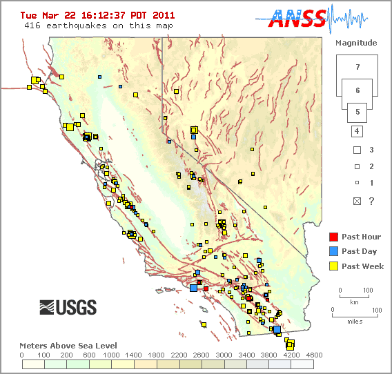
Today in California as of Noon (Tuesday: 12:07 P.M.):
T-4 hours?
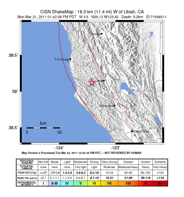
From yesterday, right near where I am right now:
3.5 2011/03/21 13:42:26 39.122N 123.418W 5.2
18 km (11 mi) W of Ukiah, CA
A couple of these are from Nevada, most likely due to proximity to CA State line.
_____________________
So far, today alone:
Mag Date Local Time Latitude Longitude Depth Location
y/m/d h:m:s deg deg km
1.1 3/22/2011 12:06:55 37.331N 121.701W 5 12 km ( 7 mi) ESE of Alum Rock, CA
1.5 3/22/2011 11:58:19 38.797N 122.765W 1.5 4 km ( 2 mi) E of The Geysers, CA
1.9 3/22/2011 11:55:30 37.319N 122.108W 0 6 km ( 3 mi) S of Los Altos, CA
2.2 3/22/2011 11:54:42 34.503N 118.659W 0.1 4 km ( 3 mi) WSW of Castaic Lake dam, CA
1.8 3/22/2011 11:31:00 40.739N 122.309W 2.3 8 km ( 5 mi) NE of Shasta Lake, CA
1.4 3/22/2011 11:22:35 34.039N 116.994W 0.1 5 km ( 3 mi) E of Yucaipa, CA
1.8 3/22/2011 11:20:48 34.098N 116.111W 25.3 6 km ( 4 mi) SW of Twentynine Palms, CA
1.4 3/22/2011 11:14:13 36.395N 120.988W 4 21 km (13 mi) SE of Pinnacles, CA
2.2 3/22/2011 11:08:25 36.048N 114.698W 7.3 21 km (13 mi) NE of Boulder City, NV
1.6 3/22/2011 10:53:55 38.847N 122.824W 1.5 6 km ( 4 mi) NNW of The Geysers, CA
1.4 3/22/2011 10:18:13 36.124N 115.759W 7 19 km (12 mi) SW of Mount Charleston, NV
1.6 3/22/2011 10:02:17 34.970N 118.002W 12.2 8 km ( 5 mi) NW of Edwards AFB, CA
1.1 3/22/2011 9:42:56 34.094N 116.959W 10.8 11 km ( 7 mi) NE of Yucaipa, CA
1.3 3/22/2011 8:06:54 38.803N 122.751W 1.1 4 km ( 3 mi) SW of Cobb, CA
1.1 3/22/2011 7:45:31 36.019N 120.604W 1.3 20 km (13 mi) NW of Parkfield, CA
1.4 3/22/2011 7:34:28 33.764N 116.131W 4.2 10 km ( 6 mi) NNE of Coachella, CA
1.1 3/22/2011 6:54:59 38.785N 122.724W 2.4 3 km ( 2 mi) WNW of Anderson Springs, CA
1.4 3/22/2011 5:51:47 38.834N 122.774W 2.6 4 km ( 3 mi) W of Cobb, CA
1.2 3/22/2011 5:48:57 38.768N 122.724W 4.1 3 km ( 2 mi) WSW of Anderson Springs, CA
1.8 3/22/2011 5:36:57 32.691N 115.818W 7.3 16 km (10 mi) SW of Seeley, CA
2 3/22/2011 3:43:12 38.822N 118.811W 4.6 16 km (10 mi) S of Schurz, NV
1.2 3/22/2011 3:34:10 33.654N 116.795W 10.9 13 km ( 8 mi) SW of Idyllwild, CA
1.7 3/22/2011 2:30:26 33.768N 116.131W 4 11 km ( 7 mi) NNE of Coachella, CA
2.4 3/22/2011 1:21:02 34.865N 116.396W 4.8 27 km (17 mi) NW of Ludlow, CA
1.7 3/22/2011 0:38:44 34.250N 117.197W 7.6 1 km ( 1 mi) SW of Lake Arrowhead, CA
1.1 3/22/2011 0:31:50 38.825N 122.828W 2.3 3 km ( 2 mi) NNW of The Geysers, CA
T-4 hours?
From yesterday, right near where I am right now:
3.5 2011/03/21 13:42:26 39.122N 123.418W 5.2
18 km (11 mi) W of Ukiah, CA
A couple of these are from Nevada, most likely due to proximity to CA State line.
_____________________
So far, today alone:
Mag Date Local Time Latitude Longitude Depth Location
y/m/d h:m:s deg deg km
1.1 3/22/2011 12:06:55 37.331N 121.701W 5 12 km ( 7 mi) ESE of Alum Rock, CA
1.5 3/22/2011 11:58:19 38.797N 122.765W 1.5 4 km ( 2 mi) E of The Geysers, CA
1.9 3/22/2011 11:55:30 37.319N 122.108W 0 6 km ( 3 mi) S of Los Altos, CA
2.2 3/22/2011 11:54:42 34.503N 118.659W 0.1 4 km ( 3 mi) WSW of Castaic Lake dam, CA
1.8 3/22/2011 11:31:00 40.739N 122.309W 2.3 8 km ( 5 mi) NE of Shasta Lake, CA
1.4 3/22/2011 11:22:35 34.039N 116.994W 0.1 5 km ( 3 mi) E of Yucaipa, CA
1.8 3/22/2011 11:20:48 34.098N 116.111W 25.3 6 km ( 4 mi) SW of Twentynine Palms, CA
1.4 3/22/2011 11:14:13 36.395N 120.988W 4 21 km (13 mi) SE of Pinnacles, CA
2.2 3/22/2011 11:08:25 36.048N 114.698W 7.3 21 km (13 mi) NE of Boulder City, NV
1.6 3/22/2011 10:53:55 38.847N 122.824W 1.5 6 km ( 4 mi) NNW of The Geysers, CA
1.4 3/22/2011 10:18:13 36.124N 115.759W 7 19 km (12 mi) SW of Mount Charleston, NV
1.6 3/22/2011 10:02:17 34.970N 118.002W 12.2 8 km ( 5 mi) NW of Edwards AFB, CA
1.1 3/22/2011 9:42:56 34.094N 116.959W 10.8 11 km ( 7 mi) NE of Yucaipa, CA
1.3 3/22/2011 8:06:54 38.803N 122.751W 1.1 4 km ( 3 mi) SW of Cobb, CA
1.1 3/22/2011 7:45:31 36.019N 120.604W 1.3 20 km (13 mi) NW of Parkfield, CA
1.4 3/22/2011 7:34:28 33.764N 116.131W 4.2 10 km ( 6 mi) NNE of Coachella, CA
1.1 3/22/2011 6:54:59 38.785N 122.724W 2.4 3 km ( 2 mi) WNW of Anderson Springs, CA
1.4 3/22/2011 5:51:47 38.834N 122.774W 2.6 4 km ( 3 mi) W of Cobb, CA
1.2 3/22/2011 5:48:57 38.768N 122.724W 4.1 3 km ( 2 mi) WSW of Anderson Springs, CA
1.8 3/22/2011 5:36:57 32.691N 115.818W 7.3 16 km (10 mi) SW of Seeley, CA
2 3/22/2011 3:43:12 38.822N 118.811W 4.6 16 km (10 mi) S of Schurz, NV
1.2 3/22/2011 3:34:10 33.654N 116.795W 10.9 13 km ( 8 mi) SW of Idyllwild, CA
1.7 3/22/2011 2:30:26 33.768N 116.131W 4 11 km ( 7 mi) NNE of Coachella, CA
2.4 3/22/2011 1:21:02 34.865N 116.396W 4.8 27 km (17 mi) NW of Ludlow, CA
1.7 3/22/2011 0:38:44 34.250N 117.197W 7.6 1 km ( 1 mi) SW of Lake Arrowhead, CA
1.1 3/22/2011 0:31:50 38.825N 122.828W 2.3 3 km ( 2 mi) NNW of The Geysers, CA
HigherLove- Posts : 2357
Join date : 2011-01-27
Age : 58
California, last two hours (it is 2:05 P.M.):
map 1.1 3/22/2011 13:43:24 38.825N 122.805W 3.2 3 km ( 2 mi) N of The Geysers, CA
map 1.2 3/22/2011 12:42:38 33.935N 117.001W 10 3 km ( 2 mi) WNW of Beaumont, CA
map 1.1 3/22/2011 13:43:24 38.825N 122.805W 3.2 3 km ( 2 mi) N of The Geysers, CA
map 1.2 3/22/2011 12:42:38 33.935N 117.001W 10 3 km ( 2 mi) WNW of Beaumont, CA
HigherLove- Posts : 2357
Join date : 2011-01-27
Age : 58
About 30 minutes away from 4:00 on the West Coast ---
Within the last hour:

Within the last hour:
HigherLove- Posts : 2357
Join date : 2011-01-27
Age : 58
Mts. Shasta and Lassen are picking up a bit the past couple of days (near town of Redding). This is the southern termination of the Cascadia Subduction zone.
Magnitude 1.7
Date-Time Tuesday, March 22, 2011 at 22:07:49 UTC
Tuesday, March 22, 2011 at 03:07:49 PM at epicenter
Location 40.426°N, 121.538°W
Depth 5.8 km (3.6 miles)
Region LASSEN PEAK AREA, CALIFORNIA
Distances
8 km (5 miles) NNE (17°) from Mineral, CA
16 km (10 miles) SE (131°) from Viola, CA
28 km (17 miles) E (88°) from Manton, CA
52 km (32 miles) SSE (168°) from Burney, CA
72 km (45 miles) ESE (103°) from Redding, CA
208 km (129 miles) N (358°) from Sacramento, CA
Location Uncertainty -horizontal +/- 0.4 km (0.2 miles); depth +/- 1.3 km (0.8 miles)
Parameters
Nph= 10, Dmin=5 km, Rmss=0.04 sec, Gp= 94°,
M-type=duration magnitude (Md), Version=0
Source
California Integrated Seismic Net:
USGSCaltechCGSUCBUCSDUNR
Event ID
nc71541250
HigherLove- Posts : 2357
Join date : 2011-01-27
Age : 58
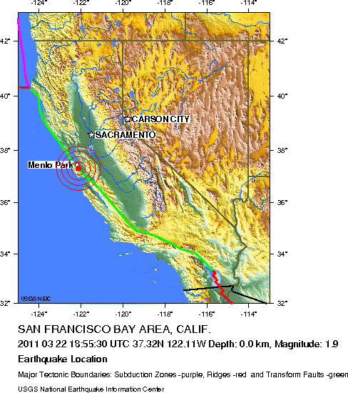
Magnitude 1.9
Date-Time 2011 03 22 18:55:30 UTC
Time of Earthquake in other Time Zones
Location 37.32N 122.11W
Depth 0.0 kilometers
Region SAN FRANCISCO BAY AREA, CALIF.
Distances
15 km (10 miles) SSE of Menlo Park, California
20 km (10 miles) W of San Jose, California
30 km (15 miles) SSW of Fremont, California
150 km (95 miles) SSW of SACRAMENTO, California
Location Quality
Error estimate: horizontal +/- 0.4 km; depth fixed by location program
Location Quality
Parameters
San Francisco Bay Area/Menlo Park:
Nst=10, Nph=10, Dmin=2 km, Rmss=0.2 sec, Gp=75.6 degrees
Source
U.S. Geological Survey, Menlo Park, California
U.C. Berkeley Seismological Laboratory, Berkeley, California
Event ID nc71541155
Right on top of San Andreas -
HigherLove- Posts : 2357
Join date : 2011-01-27
Age : 58
http://earthquake.usgs.gov/earthquakes/recenteqsus/Quakes/ci10913101.html
As we are now upon the 4:00 hour...
Los Angeles
Magnitude 2.1
Date-Time
Tuesday, March 22, 2011 at 22:54:23 UTC
Tuesday, March 22, 2011 at 03:54:23 PM at epicenter
Location 33.963°N, 118.359°W
Depth 11 km (6.8 miles)
Region GREATER LOS ANGELES AREA, CALIFORNIA
Distances
1 km (1 miles) WNW (296°) from Inglewood, CA
3 km (2 miles) N (357°) from Lennox, CA
5 km (3 miles) N (349°) from Hawthorne, CA
6 km (4 miles) NE (44°) from El Segundo, CA
15 km (9 miles) SW (225°) from Los Angeles Civic Center, CA
Location Uncertainty horizontal +/- 0.8 km (0.5 miles); depth +/- 1.5 km (0.9 miles)
Parameters
Nph= 32, Dmin=3 km, Rmss=0.5 sec, Gp= 83°,
M-type=local magnitude (ML), Version=2
Source
California Integrated Seismic Net:
USGSCaltechCGSUCBUCSDUNR
Event ID
ci10913101
Also from Los Angeles (earlier, by a few minutes):
Magnitude 1.9
Date-Time
Tuesday, March 22, 2011 at 22:43:20 UTC
Tuesday, March 22, 2011 at 03:43:20 PM at epicenter
Location
34.153°N, 118.613°W
Depth 16.5 km (10.3 miles)
RegionGREATER LOS ANGELES AREA, CALIFORNIA
Distances
2 km (1 miles) SSW (207°) from Woodland Hills, CA
5 km (3 miles) ENE (70°) from Calabasas, CA
5 km (3 miles) ESE (110°) from Hidden Hills, CA
18 km (11 miles) SE (139°) from Simi Valley, CA
24 km (15 miles) E (100°) from Thousand Oaks, CA
35 km (22 miles) WNW (288°) from Los Angeles Civic Center, CA
Location Uncertainty
horizontal +/- 2.4 km (1.5 miles); depth +/- 7.1 km (4.4 miles)
Parameters
Nph= 13, Dmin=28 km, Rmss=0.64 sec, Gp=234°,
M-type=local magnitude (ML), Version=2
Source
California Integrated Seismic Net:
USGSCaltechCGSUCBUCSDUNR
Event ID
ci10913061
NOTE: This could very well be just another day. These quakes are normal.
HigherLove- Posts : 2357
Join date : 2011-01-27
Age : 58
Magnitude 2.2
Date-Time
Tuesday, March 22, 2011 at 23:06:15 UTC
Tuesday, March 22, 2011 at 04:06:15 PM at epicenter
Location
33.657°N, 116.763°W
Depth 15.6 km (9.7 miles)
Region
SOUTHERN CALIFORNIA
Distances
11 km (7 miles) SSW (205°) from Idyllwild, CA
14 km (9 miles) NW (323°) from Anza, CA
16 km (10 miles) SE (131°) from Valle Vista, CA
22 km (14 miles) ESE (115°) from Hemet, CA
28 km (18 miles) SW (229°) from Palm Springs, CA
104 km (64 miles) NNE (20°) from San Diego, CA
Location Uncertainty
horizontal +/- 0.2 km (0.1 miles); depth +/- 0.5 km (0.3 miles)
Parameters
Nph= 96, Dmin=7 km, Rmss=0.32 sec, Gp= 54°,
M-type=local magnitude (ML), Version=2
Source
California Integrated Seismic Net:
USGSCaltechCGSUCBUCSDUNR
Event ID
ci10913197
HigherLove- Posts : 2357
Join date : 2011-01-27
Age : 58
Past Hour:
http://www.themistsofavalon.net/t2207-significant-harmonics-and-shaking-registering-on-global-seismic-monitors-3-22#40690
In post #4, Carol lists different URLs for updates. I have noticed that they do not all match, or that in some cases, not all quakes are reported on every map. :op
http://www.themistsofavalon.net/t2207-significant-harmonics-and-shaking-registering-on-global-seismic-monitors-3-22#40690
In post #4, Carol lists different URLs for updates. I have noticed that they do not all match, or that in some cases, not all quakes are reported on every map. :op
HigherLove- Posts : 2357
Join date : 2011-01-27
Age : 58
Heading home, so settle down for a bit, eh? Come on, May!
___________
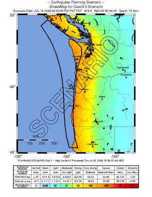
Deterministic and Scenario Ground-Motion Maps
http://earthquake.usgs.gov/hazards/products/scenario/
___________
Deterministic and Scenario Ground-Motion Maps
http://earthquake.usgs.gov/hazards/products/scenario/

mudra- Posts : 23229
Join date : 2010-04-09
Age : 69
Location : belgium
HigherLove wrote:Heading home, so settle down for a bit, eh? Come on, May!
___________
Two Days We Should Not Worry
Author Unknown
There are two days in every week, about which we should not worry,
two days which should be kept free from fear and apprehension.
One of these days is Yesterday, with all its mistakes and cares,
its faults and blunders, its aches and pains.
Yesterday has passed forever beyond our control.
All the money in the world cannot bring back Yesterday.
We cannot undo a single act we performed;
we cannot erase a single word we said.
Yesterday is gone forever.
The other day we should not worry about is Tomorrow
with all its possible adversities, its burdens,
its large promise and its poor performance;
Tomorrow is also beyond our immediate control.
Tomorrow's sun will rise,
either in splendor or behind a mask of clouds, but it will rise.
Until it does, we have no stake in Tomorrow,
for it is yet to be born.
This leaves only one day, Today.
Any person can fight the battle of just one day.
It is when you and I add the burdens of those two awful eternities,
Yesterday and Tomorrow, that we break down.
It is not the experience of Today that drives a person mad,
it is the remorse or bitterness of something which happened
Yesterday and the dread of what Tomorrow may bring.
Let us, therefore,
Live but one day at a time.
Peace in your Heart HigherLove
:heart2:
Love always
mudra
HigherLove- Posts : 2357
Join date : 2011-01-27
Age : 58
mudra wrote:HigherLove wrote:Heading home, so settle down for a bit, eh? Come on, May!
___________
Two Days We Should Not Worry
Peace in your Heart HigherLove
:heart2:
Love always
mudra
Oh, Mudra! I so adore your energy. Thank you.
I know I post a lot, but it's more because at times it is fun. Part of it is research. Earthquake prediction seems quite tricky, whether mainstream science or alternative means. So, some of it is verification/"fact" checking (I am going to start looking at the trends).
I accepted years ago that earthquakes are part of this west coast trip.
Eventually, someone will be right and a really big quake will hit.
Even so, given my track record, I will probably be there. LOL
LOVE TO YOU!!!!!!!!!!!!!!
HigherLove- Posts : 2357
Join date : 2011-01-27
Age : 58
Like I said - "normal" - hehe
This hit just as I was driving through. It is 3 of my 5 days of commuting. :op
Magnitude 1.3
Date-Time Wednesday, March 23, 2011 at 00:45:41 UTC
Tuesday, March 22, 2011 at 05:45:41 PM at epicenter
Location 39.162°N, 122.988°W
Depth 13.2 km (8.2 miles)
Region NORTHERN CALIFORNIA
Distances 7 km (4 miles) W (275°) from Upper Lake, CA
11 km (7 miles) NW (321°) from North Lakeport, CA
13 km (8 miles) WNW (288°) from Nice, CA
19 km (12 miles) E (86°) from Ukiah, CA
148 km (92 miles) WNW (298°) from Sacramento, CA
Location Uncertainty horizontal +/- 0.7 km (0.4 miles); depth +/- 1.5 km (0.9 miles)
Parameters Nph= 6, Dmin=8 km, Rmss=0.01 sec, Gp=220°,
M-type=duration magnitude (Md), Version=2
Source California Integrated Seismic Net:
USGS Caltech CGS UCB UCSD UNR
Event ID nc71541325
map 2.0 2011/03/22 18:47:57 38.817N 122.793W 2.7 2 km ( 1 mi) NNE of The Geysers, CA
map 1.3 2011/03/22 17:45:41 39.162N 122.988W 13.2 7 km ( 4 mi) W of Upper Lake, CA
Carol- Admin
- Posts : 31801
Join date : 2010-04-07
Location : Hawaii
In 1 hour and 15 minutes, LA has received 8 earthquakes.
_________________
What is life?
It is the flash of a firefly in the night, the breath of a buffalo in the wintertime. It is the little shadow which runs across the grass and loses itself in the sunset.
With deepest respect ~ Aloha & Mahalo, Carol
HigherLove- Posts : 2357
Join date : 2011-01-27
Age : 58
Carol wrote:In 1 hour and 15 minutes, LA has received 8 earthquakes.
Activity has clearly picked up. I cannot deny that.
It was just quakes in the geysers, but there are little ones just popping all over the place.
While the fault zones in my neck of the woods are "bound", we are still subject to San Andreas, and others. My family said that the '89 Loma Prieta quake shook the crap out of this place, as well. On the other side of Mt. St. Helena are Napa and Sonoma Counties (to my south). As you may know, Santa Rosa is in Sonoma County. I lived there for 13 years. It was leveled in 1906 from San Andreas, but a local fault took the downtown down a couple of times in the 50's and 60s.
And the Gorda subduction plate kicks the crap out of Eureka and Fortuna (Note to self: revisit Carson Mansion).
In Mendocino County, brick buildings that are not reinforced display ominous warning signs about the dangers of quakes. I do tend to avoid unreinforced masonry, if at all possible. And, having quakes in Ukiah and near Upper Lake are not that common. I drove from one and through the other, with quakes on both ends. It's ridiculous. I am starting to take it personally.

Jenetta- Posts : 1978
Join date : 2010-04-16
Location : British Columbia Canada
WIn Mendocino County, brick buildings that are not reinforced display ominous warning signs about the dangers of quakes. I do tend to avoid unreinforced masonry, if at all possible. And, having quakes in Ukiah and near Upper Lake are not that common. I drove from one and through the other, with quakes on both ends. It's ridiculous. I am starting to take it personally.
Your the center of the "teeter-totter" Higher Love...keep it up

____________________________________________________
Drinking

HigherLove- Posts : 2357
Join date : 2011-01-27
Age : 58
lindabaker wrote:HigherLove, is your car repaired yet? Keep us informed, please. Thank you. Linda
Off topic, but I want to focus on the positive for a moment.
My car has been in the shop for 24 days. My account was hit yesterday by the car rental agency, and I was told that the rental had only been approved through last Friday.
Thinking I had dropped the ball, I called the repair shop to see what I needed to do to make things right.
Before I could, they apologized, profusely, and said it was their fault. Apparently they have a trainee. The rocks from the plow exploded my back window. The new guy replaced it, but he replaced it with another broken window. :op They are waiting for yet another one to come in (it has already been painted and cleaned).
I told them that my insurance did not approve an alignment, since technically I did not have an accident. I was told they would throw in an alignment for free, and that when my car is ready, I am not to pay a dime. They said they trust me and we can work out the details, later. ("They" is a she - Kelly). She is overriding her boss. I have her personal cell phone number. She was going to wait until today to ream the car rental agency.
Sweeeet!
And I still have a nice rental.
_________________________
To keep this somewhat relevant, there was another quake in the geysers, around 6:42, this morning (nature's alarm clock?). It was a 1.1. Again, this is common.
As Dutch (or Mudra) might say: much love during these times.
HigherLove- Posts : 2357
Join date : 2011-01-27
Age : 58
Jenetta wrote:
WIn Mendocino County, brick buildings that are not reinforced display ominous warning signs about the dangers of quakes. I do tend to avoid unreinforced masonry, if at all possible. And, having quakes in Ukiah and near Upper Lake are not that common. I drove from one and through the other, with quakes on both ends. It's ridiculous. I am starting to take it personally.

I like the "teeter-totter" analogy. lol Cute. It has felt like that.
I think that at times, then I think of the suffering in Japan - the likes of which I cannot comprehend. My worries just pale in comparison.
I have even had to stop and ask myself if my role is as a protector, or if I am like Klaatu, and just visiting places to get things started with "Project Restore Earth". I guess either way I would be a protector, but protector of what?
I am a friend to the Earth (more the last few months than ever), but I don't want anybody to hurt of suffer. :op
____________________
Clear Lake is predicted to pass flood stage by this Friday. Should the lake ever fill with acids from volcanic activity, send in Dolores Roberts ("Dante's Peak") for any lake rescues. I'll be too busy asking myself why I am still near a volcano. hehe
Edit:
Wait...
Konocti
Shasta
Lassen
Make that 3 volcanoes.
Still you could not pay me to live in Seattle or Los Angeles (Seattle is gorgeous, but L.A. is, well...y'all know).
HigherLove- Posts : 2357
Join date : 2011-01-27
Age : 58
Similar topics
» REMEMBER HALIBURTON? AND THE GULF OF MEXICO OIL SPILL? North Atlantic Current (also called the North Atlantic Drift) no longer exists and along with it the Norway Current.
» Scientists fear tension building on dangerous fault near Istanbul, Turkey
» New Madrid Fault and on-going reports of booming sounds. A connection?
» NewMadrid fault line: 2011 military plans and Haarp
» The Cascadia Fault Line: Locked, Loaded And Ready To Fire
» Scientists fear tension building on dangerous fault near Istanbul, Turkey
» New Madrid Fault and on-going reports of booming sounds. A connection?
» NewMadrid fault line: 2011 military plans and Haarp
» The Cascadia Fault Line: Locked, Loaded And Ready To Fire