


+30
Arrowwind
THEeXchanger
malletzky
LeeEllisMusic
CetaceousOne
MzKarma
greybeard
Brook
lawlessline
MargueriteBee
HigherLove
Jonah
solent
devakas
Micjer
Sanicle
hobbit
Mercuriel
immortalisdolor
giovonni
Floyd
Jenetta
enemyofNWO
lindabaker
JesterTerrestrial
gscraig
AscendingStarseed
mudra
burgundia
Carol
34 posters

Earth Changes 2013 - Daily Updates


Carol- Admin

- Posts : 31756
Join date : 2010-04-07
Location : Hawaii
_________________
What is life?
It is the flash of a firefly in the night, the breath of a buffalo in the wintertime. It is the little shadow which runs across the grass and loses itself in the sunset.
With deepest respect ~ Aloha & Mahalo, Carol

Carol- Admin
- Posts : 31756
Join date : 2010-04-07
Location : Hawaii
_________________
What is life?
It is the flash of a firefly in the night, the breath of a buffalo in the wintertime. It is the little shadow which runs across the grass and loses itself in the sunset.
With deepest respect ~ Aloha & Mahalo, Carol
Carol- Admin
- Posts : 31756
Join date : 2010-04-07
Location : Hawaii

http://www.weather.com/news/weather-winter/cold-plunge-below-zero-frostbite-20130115?pageno=2
Coldest Air of the Season
_________________
What is life?
It is the flash of a firefly in the night, the breath of a buffalo in the wintertime. It is the little shadow which runs across the grass and loses itself in the sunset.
With deepest respect ~ Aloha & Mahalo, Carol
Carol- Admin
- Posts : 31756
Join date : 2010-04-07
Location : Hawaii

Arctic cold continues to sweep the North
Bitter temps to last into early Thursday
(CNN) —How cold is minus 20 degrees really? Cold enough to freeze an egg sunny-side up.
Read more: http://www.kitv.com/news/national/Arctic-cold-continues-to-sweep-the-North/-/8905418/18221516/-/rtf11hz/-/index.html#ixzz2IiwEM5G6
_________________
What is life?
It is the flash of a firefly in the night, the breath of a buffalo in the wintertime. It is the little shadow which runs across the grass and loses itself in the sunset.
With deepest respect ~ Aloha & Mahalo, Carol
Carol- Admin
- Posts : 31756
Join date : 2010-04-07
Location : Hawaii
https://www.youtube.com/watch?v=2_cg_-RlDbo&feature=player_embedded
Magnetic North Pole Moving Toward Siberia
_________________
What is life?
It is the flash of a firefly in the night, the breath of a buffalo in the wintertime. It is the little shadow which runs across the grass and loses itself in the sunset.
With deepest respect ~ Aloha & Mahalo, Carol

lawlessline- Posts : 699
Join date : 2010-04-23
Age : 51
Massive melting of Andes glaciers
COMMENTS (715)
The tropical glaciers are melting at their fastest rate in 300 years
Glacier threat to Bolivia capital
The vanishing glaciers of Ecuador
Glaciers in the tropical Andes have shrunk by 30-50% since the 1970s, according to a study.
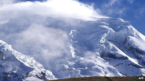
http://www.bbc.co.uk/news/science-environment-21163386

t
COMMENTS (715)
The tropical glaciers are melting at their fastest rate in 300 years
Glacier threat to Bolivia capital
The vanishing glaciers of Ecuador
Glaciers in the tropical Andes have shrunk by 30-50% since the 1970s, according to a study.
http://www.bbc.co.uk/news/science-environment-21163386
t

mudra- Posts : 23221
Join date : 2010-04-09
Age : 69
Location : belgium
Climate Change Update (24 January 2013) "Nuke Effect" snow
https://www.youtube.com/watch?v=lBBKevc28Xc
Climate Change Update (27 January 2013) Iran's Fordo nuclear facility
https://www.youtube.com/watch?v=WmuenbDPWo8
Love Always
mudra
https://www.youtube.com/watch?v=lBBKevc28Xc
Climate Change Update (27 January 2013) Iran's Fordo nuclear facility
https://www.youtube.com/watch?v=WmuenbDPWo8
Love Always
mudra
Carol- Admin
- Posts : 31756
Join date : 2010-04-07
Location : Hawaii
.
The Big Chill: unusual stratospheric phenomenon is bringing frigid cold to U.S

January 23, 2013 – CLIMATE – An unusual event playing out high in the atmosphere above the Arctic Circle is setting the stage for what could be weeks upon weeks of frigid cold across wide swaths of the U.S., having already helped to bring cold and snowy weather to parts of Europe. Forecast high temperatures on Monday, Jan. 21, from the GFS computer model. This phenomenon, known as a “sudden stratospheric warming event,” started on Jan. 6, but is something that is just beginning to have an effect on weather patterns across North America and Europe. While the physics behind sudden stratospheric warming events are complicated, their implications are not: such events are often harbingers of colder weather in North America and Eurasia. The ongoing event favors colder and possibly stormier weather for as long as four to eight weeks after the event, meaning that after a mild start to the winter, the rest of this month and February could bring the coldest weather of the winter season to parts of the U.S., along with a heightened chance of snow. Sudden stratospheric warming events take place in about half of all Northern Hemisphere winters, and they have been occurring with increasing frequency during the past decade, possibly related to the loss of Arctic sea ice due to global warming. Arctic sea ice declined to its smallest extent on record in September 2012. Sudden stratospheric warming events occur when large atmospheric waves, known as Rossby waves, extend beyond the troposphere where most weather occurs, and into the stratosphere. This vertical transport of energy can set a complex process into motion that leads to the breakdown of the high altitude cold low pressure area that typically spins above the North Pole during the winter, which is known as the polar vortex. The polar vortex plays a major role in determining how much Arctic air spills southward toward the mid-latitudes. When there is a strong polar vortex, cold air tends to stay bottled up in the Arctic. However, when the vortex weakens or is disrupted, like a spinning top that suddenly starts wobbling, it can cause polar air masses to surge south, while the Arctic experiences milder-than-average temperatures. During the ongoing stratospheric warming event, the polar vortex split in two, allowing polar air to spill out from the Arctic, as if a refrigerator door were suddenly opened. For reasons I don’t think we fully understand, the changes in the circulation that happen in the stratosphere [can] descend down all the way to the Earth’s surface,” said Judah Cohen, director of seasonal forecasting at Atmospheric and Environmental Research (AER) in Massachusetts. As the polar stratosphere warms, high pressure builds over the Arctic, causing the polar jet stream to weaken. At the same time, the mid-latitude jet stream strengthens, while also becoming wavier, with deeper troughs and ridges corresponding to more intense storms and high pressure areas. In fact, sudden stratospheric warming events even make so-called “blocked” weather patterns more likely to occur, which tilts the odds in favor of the development of winter storms in the U.S. and Europe. –Climate CentralThe Big Chill: unusual stratospheric phenomenon is bringing frigid cold to U.S
_________________
What is life?
It is the flash of a firefly in the night, the breath of a buffalo in the wintertime. It is the little shadow which runs across the grass and loses itself in the sunset.
With deepest respect ~ Aloha & Mahalo, Carol
Carol- Admin
- Posts : 31756
Join date : 2010-04-07
Location : Hawaii
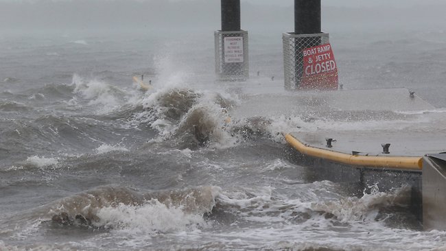
Once in a century flooding gives Queensland an unexpected sequel: 4 killed
_________________
What is life?
It is the flash of a firefly in the night, the breath of a buffalo in the wintertime. It is the little shadow which runs across the grass and loses itself in the sunset.
With deepest respect ~ Aloha & Mahalo, Carol
Carol- Admin
- Posts : 31756
Join date : 2010-04-07
Location : Hawaii

http://www.spacedaily.com/reports/Major_floods_hammer_northern_Australia_999.html
Major floods hammer northern Australia
http://www.spacedaily.com/reports/Indonesia_bid_to_control_rain_to_avert_more_floods_999.html
Indonesia bid to control rain to avert more floods

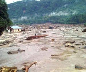
http://www.spacedaily.com/reports/Mozambique_floods_prompt_humanitarian_crisis_999.html
Mozambique floods prompt humanitarian crisis
River with what little they could carry.
January 29, 2013 – AFRICA – At least 150,000 people have been displaced in Mozambique due to intense flooding, according to the United Nations. The UN said on Tuesday that the number displaced is expected to rise as fresh rains spread flooding northward. At least 40 people have been killed so far by heavy rains and overflowing rivers in the southeastern African country, which is experiencing its worst floods in more than a decade. “People in high-risk areas are still being rescued,” Rita Almeida, a spokeswoman for Mozambique’s National Disaster Management Institute, said. “We are asking people to move out of houses that could be destroyed by rain,” Almeida said. The south of the country has been worst-hit by the flood surge, especially in the province of Gaza where 150,000 residents have been forced to flee to higher ground, Patricia Nakell, a UN spokesperson, said. The town of Chokwe, which had been badly damaged in floods 13 years ago, was once again devastated and residents sought refuge on rooftops. The UN is coordinating relief efforts with non-governmental organizations. Aid agencies and government emergency services have set up temporary camps in elevated areas to aid the flood victims. “The main needs are tents and clean water, but they basically need everything,” said Katherine Mueller, a spokeswoman for the International Federation of Red Cross and Red Crescent Societies. “There will be a huge need of sanitation, mosquito nets, shelter, kitchen sets and blankets as families begin returning home in the coming weeks.” Water levels on the Limpopo River are reportedly at higher levels than those recorded during the deadly floods in 2000. The deluge is expected to swell the Zambezi river basin, spreading the disaster to northern and central Mozambique. –Al Jazeera
Last edited by Carol on Wed Jan 30, 2013 11:34 am; edited 1 time in total
_________________
What is life?
It is the flash of a firefly in the night, the breath of a buffalo in the wintertime. It is the little shadow which runs across the grass and loses itself in the sunset.
With deepest respect ~ Aloha & Mahalo, Carol
mudra- Posts : 23221
Join date : 2010-04-09
Age : 69
Location : belgium
Climate Change Update (29 January 2013) TEPCO Pumps Nuclear Waste
https://www.youtube.com/watch?v=-VldtZG5Gr0
Love Always
mudra
https://www.youtube.com/watch?v=-VldtZG5Gr0
Love Always
mudra
Carol- Admin
- Posts : 31756
Join date : 2010-04-07
Location : Hawaii
The threat of severe thunderstorms is about to return as a strong cold front emerges from the Rockies and intercepts milder air returning to the nation's midsection.
Wednesday Forecast
This pattern will be favorable for thunderstorms to produce damaging winds and possible tornadoes Tuesday and Wednesday in parts of the South, lower Midwest, and eventually the Mid-Atlantic region. The maps on this page show the latest timing forecast for these storms from The Weather Channel's Global Forecast Center. http://www.weather.com/news/weather-severe/severe-weather-tracker
_________________
What is life?
It is the flash of a firefly in the night, the breath of a buffalo in the wintertime. It is the little shadow which runs across the grass and loses itself in the sunset.
With deepest respect ~ Aloha & Mahalo, Carol
Carol- Admin
- Posts : 31756
Join date : 2010-04-07
Location : Hawaii

Nine people killed as freak hailstorm rains massive boulders down on Indian villages
The hail storm covered the entire villages under the snow like blanket
Destroyed crops, houses and live stock in seven villages
The hailstones started falling from the sky on Tuesday night
_________________
What is life?
It is the flash of a firefly in the night, the breath of a buffalo in the wintertime. It is the little shadow which runs across the grass and loses itself in the sunset.
With deepest respect ~ Aloha & Mahalo, Carol
Carol- Admin
- Posts : 31756
Join date : 2010-04-07
Location : Hawaii
Heaviest Snowfall in a Century Hits Moscow
http://www.themoscowtimes.com/news/article/heaviest-snowfall-in-a-century-hits-moscow/475102.html
The heaviest snowfall in a century brought Moscow and the surrounding region to a near standstill and left hundreds of people without power, officials said Tuesday.http://www.themoscowtimes.com/news/article/heaviest-snowfall-in-a-century-hits-moscow/475102.html
And with snowfall set to continue at least until the end of the week, the authorities are bracing for more chaos on the roads.
"There hasn't been such a winter in 100 years," Pyotr Biryukov, deputy mayor for residential issues, said Tuesday in comments carried by Interfax. "The snow this year has already reached one and a half times the climatic norm," he said.
The capital has seen 216 centimeters of snow fall since the beginning of winter, Biryukov said.
Average snowfall in Moscow is 152 centimeters a year. Biryukov said the city saw 26 centimeters in the 24 hours preceding his Tuesday afternoon news conference and has seen 36 centimeters since the beginning of February.
Read more: http://www.themoscowtimes.com/news/article/heaviest-snowfall-in-a-century-hits-moscow/475102.html#ixzz2K6B7t85f
The Moscow Times
_________________
What is life?
It is the flash of a firefly in the night, the breath of a buffalo in the wintertime. It is the little shadow which runs across the grass and loses itself in the sunset.
With deepest respect ~ Aloha & Mahalo, Carol
Carol- Admin
- Posts : 31756
Join date : 2010-04-07
Location : Hawaii

Blizzard to Bury New England at the End of the Week
http://www.accuweather.com/en/weather-news/blizzard-to-bury-new-england-at-the-end-of-week/5673457
Winter Storm Nemo: Nor'easter Looms
Video link: http://www.weather.com/news/weather-winter/winter-storm-nemo-20130206
12 inches or more up to 2 feet
Snowstorm Friday Has Potential To Be Historic
http://boston.cbslocal.com/2013/02/06/snowstorm-friday-has-potential-to-be-historic/
BOSTON (CBS) - The snowstorm Friday will be big, but will it be historic and rival some of the legendary storms of Boston’s past? The short answer is it just might. I think it is safe to say that Friday’s storm will easily be the biggest one of not only this season but last season as well.Video link: http://www.weather.com/news/weather-winter/winter-storm-nemo-20130206
12 inches or more up to 2 feet
Snowstorm Friday Has Potential To Be Historic
http://boston.cbslocal.com/2013/02/06/snowstorm-friday-has-potential-to-be-historic/
_________________
What is life?
It is the flash of a firefly in the night, the breath of a buffalo in the wintertime. It is the little shadow which runs across the grass and loses itself in the sunset.
With deepest respect ~ Aloha & Mahalo, Carol
Carol- Admin
- Posts : 31756
Join date : 2010-04-07
Location : Hawaii

http://www.accuweather.com/en/weather-news/blizzard-to-bury-new-england-at-the-end-of-week/5673457
The National Weather Service in Mobile has issued an:
southeastern Escambia County in northwest Florida...
southeastern Baldwin County in southwest Alabama...
* until 1000 am CST
* at 800 am CST... showers and thunderstorms moving over the
advisory area have produced 1 to 2 inches of rainfall over the past
hour... and an additional 1 to 1.5 inches will be possible through
1000 am CST. This will result in minor flooding of poor drainage and
low lying areas and ponding of water on roadways.
* Locations impacted include...
Pensacola international Airport... Perdido Beach...
Orange Beach... West Pensacola... Warrington...
Pensacola... Myrtle Grove... Goulding...
Brent...
Precautionary/preparedness actions...
Excessive rainfall runoff will cause ponding of water in urban
areas... highways... streets and underpasses as well as other poor
drainage areas and low lying spots.
Lat... Lon 3027 8764 3043 8755 3049 8724 3047 8715
3043 8717 3039 8721 3038 8726 3033 8727
3033 8720 3035 8715 3033 8713 3032 8715
3031 8725 3032 8731 3029 8742
Special Statement..
.. A line of strong thunderstorms will affect southeastern Baldwin
County in southwest Alabama... western Santa Rosa and southern
Escambia counties in northwest Florida... through 945 am CST...
At 825 am CST... a line of strong thunderstorms was located along a
line extending from 8 miles southeast of Robertsdale to 4 miles east
of Foley to 4 miles north of Gulf Shores... and moving east at 40 mph.
* Locations impacted include...
Perdido Beach... Orange Beach... Gulf Shores...
Gonzalez... Ensley... Bellview...
Lillian... Foley... Elberta...
This includes Interstate 10 in Florida between mile markers 1 and 10.
This includes Interstate 10 in Alabama between mile markers 49 and
66.
The primary threats from these storms are wind gusts up to 55 mph.
Winds this strong could blow off tree limbs and also blow around
small unsecured objects. Seek shelter until these storms have passed.
These storms may continue to intensify and a warning may soon be
needed. Please continue to monitor local radio or TV for further
National Weather Service updates or possible warnings
_________________
What is life?
It is the flash of a firefly in the night, the breath of a buffalo in the wintertime. It is the little shadow which runs across the grass and loses itself in the sunset.
With deepest respect ~ Aloha & Mahalo, Carol
Carol- Admin
- Posts : 31756
Join date : 2010-04-07
Location : Hawaii
Published on Feb 2, 2013
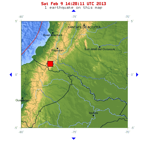
Earth reeling from eight major earthquakes striking in 5 days
http://www.sott.net/category/4-Earth-Changes
Fields of fire: 4 volcanoes now erupting simultaneously in Kamchatka
http://theextinctionprotocol.wordpress.com
http://www.sott.net/category/4-Earth-Changes
The National Weather Service forecasts blizzard conditions in New England by late Friday afternoon.
As much as 2 feet of snow could fall on a region that has seen mostly bare ground this winter, the National Weather Service said. That's exciting for resort operators who haven't had much snow this year.
The storm would hit just after the 35th anniversary of the historic blizzard of 1978, which paralyzed the region with more than 2 feet of snow and hurricane force winds from Feb. 5-7.
"This has the potential for being a dangerous storm, especially for Massachusetts into northeast Connecticut and up into Maine," said Louis Uccellini, director of the weather agency's National Centers for Environmental Prediction.
Gov't warns of impending quake shortly before M6.9 hit northern Japan — "Make yourself safe, turn off the gas..."
[No radiation involved] "Most of the presented vegetables were deformed from Nishigo mura Fukushima"
Posted by Mochizuki on February 2nd, 2013
http://fukushima-diary.com/category/dnews/
_________________
What is life?
It is the flash of a firefly in the night, the breath of a buffalo in the wintertime. It is the little shadow which runs across the grass and loses itself in the sunset.
With deepest respect ~ Aloha & Mahalo, Carol
Carol- Admin
- Posts : 31756
Join date : 2010-04-07
Location : Hawaii

Snowiest winter in 100 years paralyzes Moscow traffic for 3,500 km
Earthchanges: Earth’s weather goes haywire
“Earth’s stability is collapsing…and one by one, the biospheric processes regulating life itself are going awry. These are early characteristics of climate shock and are indications that even more ominous changes are yet to unfold…areas of the Earth…will become increasingly inhospitable from the extremes of climate change. As incredible as it seems, we’re witnessing signs of epochal change-across the planet which are typically consigned to geological periods of planetary extinctions. The climate stability, we once knew, is gone forever.” –The Extinction Protocol – page 9, 2009[left]
_________________
What is life?
It is the flash of a firefly in the night, the breath of a buffalo in the wintertime. It is the little shadow which runs across the grass and loses itself in the sunset.
With deepest respect ~ Aloha & Mahalo, Carol
Carol- Admin
- Posts : 31756
Join date : 2010-04-07
Location : Hawaii

http://www.telegraph.co.uk/news/worldnews/northamerica/usa/9856701/US-bracing-for-historic-blizzard.html
US bracing for 'historic' blizzard
_________________
What is life?
It is the flash of a firefly in the night, the breath of a buffalo in the wintertime. It is the little shadow which runs across the grass and loses itself in the sunset.
With deepest respect ~ Aloha & Mahalo, Carol
Carol- Admin
- Posts : 31756
Join date : 2010-04-07
Location : Hawaii
Published on Feb 6, 2013
A decade of below normal rain and snow, plus higher temperatures is causing Lake Huron and Lake Michigan to look more like great puddles than Great Lakes. The U.S. Army Corps of Engineers says other Great Lakes - Superior, Erie, and Ontario - are also well-below average. Kristina Behr has the story.
 February 8, 2013 – GREAT LAKES, US - Two of the Great Lakes have hit their lowest water levels ever recorded, the U.S. Army Corps of Engineers said Tuesday, capping more than a decade of below-normal rain and snowfall and higher temperatures that boost evaporation. Measurements taken last month show Lake Huron and Lake Michigan have reached their lowest ebb since record keeping began in 1918, and the lakes could set additional records over the next few months, the corps said. The lakes were 29 inches below their long-term average and had declined 17 inches since January 2012. The other Great Lakes — Superior, Erie and Ontario — were also well below average. “We’re in an extreme situation,” said Keith Kompoltowicz, watershed hydrology chief for the corps district office in Detroit. The low water has caused heavy economic losses by forcing cargo ships to carry lighter loads, leaving boat docks high and dry, and damaging fish-spawning areas. And vegetation has sprung up in newly exposed shoreline bottomlands, a turnoff for hotel customers who prefer sandy beaches. The corps’ report came as shippers pleaded with Congress for more money to dredge ever-shallower harbors and channels. Shippers are taxed to support a harbor maintenance fund, but only about half of the revenue is spent on dredging. The remainder is diverted to the treasury for other purposes. Legislation to change that policy is pending before Congress. “Plunging water levels are beyond anyone’s control, but the dredging crisis is man-made,” said James Weakley, president of the Cleveland-based Lake Carriers’ Association. Kompoltowicz said the Army corps might reconsider a long-debated proposal to place structures in a river to reduce the flow of water away from Lakes Huron and Lake Michigan, which are connected. Scientists say lake levels are cyclical and controlled mostly by nature. They began a steep decline in the late 1990s and have usually lagged well below their historical averages since then. But studies have shown that Huron and Michigan fell by 10 to 16 inches because of dredging over the years to deepen the navigational channel in the St. Clair River, most recently in the 1960s. Dredging of the river, which is on the south end of Lake Huron, accelerated the flow of water southward from the two lakes toward Lake Erie and Lake Ontario, and eventually into the Atlantic Ocean. Groups representing shoreline property owners, primarily in Lake Huron’s Georgian Bay, have demanded action to slow the Lake Huron and Michigan outflow to make up for losses that resulted from dredging, which they contend are even greater than officials have acknowledged. Although the Army corps produced a list of water-slowing options in 1972, including miniature dams and sills that resemble speed bumps along the river bottom, nothing was done because the lakes were in a period of above-average levels that lasted nearly three decades, Kompoltowicz said. The corps has congressional authorization to take action but would need money for an updated study as a first step, he said. The Detroit office is considering a funding request, but it would have to compete with other projects nationwide and couldn’t get into the budget before 2015. “It’s no guarantee that we’re going to get it, especially in this budget climate,” Kompoltowicz said. “But there are serious impacts to navigation and shoreline property owners from this extreme event. It’s time to revisit this.” Roger Gauthier, a retired staff hydrologist with the Army corps, said a series of “speed bumps” could be put in the river at a reasonable cost within a few years. Without such measures, he warned, “it would take years of consistent rain” to return Lake Michigan and Lake Huron to normal. –Yahoo News
A decade of below normal rain and snow, plus higher temperatures is causing Lake Huron and Lake Michigan to look more like great puddles than Great Lakes. The U.S. Army Corps of Engineers says other Great Lakes - Superior, Erie, and Ontario - are also well-below average. Kristina Behr has the story.
Last edited by Carol on Sat Feb 09, 2013 9:48 am; edited 1 time in total
_________________
What is life?
It is the flash of a firefly in the night, the breath of a buffalo in the wintertime. It is the little shadow which runs across the grass and loses itself in the sunset.
With deepest respect ~ Aloha & Mahalo, Carol
Carol- Admin
- Posts : 31756
Join date : 2010-04-07
Location : Hawaii

Crustal upheaval near Santa Cruz Islands signals planet undergoing massive change
Planet in crisis: “We are entering an era of increased planetary instability, brought on by a significant rise in the geothermal gradient, and subsequent magmatic fluid expansion within the planet’s interior. It will be a time, in which, we will see catastrophic and exponential increases in the number of natural disasters- most notably: earthquakes, storms, and volcanic eruptions. Yet, it is not the number of earthquakes that will strike the planet in the future that should most concern us. It will be the cluster eruption of mega-quakes, and their resonate aftermath, which will signal the planet has entered an intensified cataclysmic period of transition…these quakes will signal the secondary stage of Earth’s thermal acceleration, and should come to be viewed as signs of increasing disorder. Some of the quakes will strike as singular events; others will erupt in clusters, and some will strike some of the world’s most dangerous faults…this time will be marked by increased tectonic plate agitation, and an increase in the outbreak of the most powerful and destructive type of earthquakes, known as mega-thrust earthquakes.” –The Extinction Protocol, pp. 166,167,172 (2009)
_________________
What is life?
It is the flash of a firefly in the night, the breath of a buffalo in the wintertime. It is the little shadow which runs across the grass and loses itself in the sunset.
With deepest respect ~ Aloha & Mahalo, Carol
Carol- Admin
- Posts : 31756
Join date : 2010-04-07
Location : Hawaii

Storm Pattern Overview From February 9 to February 23!!!
Succession of 4 east coast storms starting next Thursday!!!
Full article and graphics: http://theweathercentre.blogspot.de
Saturday, February 9, 2013Pattern Overview From February 9 to February 23
By Andrew at 2:02 PM
This is a discussion of the atmospheric pattern from February 9th through February 23rd.
Our analysis begins with the tropical convection index called the Madden-Julian Oscillation, or MJO. We currently see the MJO in Phase 1, with the strongest tropical convection occurring in west Africa or into the Indian Ocean.
When the Madden Julian Oscillation is in Phase 1 during the second half of winter into March, cooler temperatures tend to prevail across many areas east of the Front Range, especially prevalent in the Great Lakes and into the Northeast. Temperature anomalies can average a few degrees below normal, and this phase is best known for providing the aforementioned regions with the best opportunities for cold outbreaks. We are not seeing that cold trend get too strong at this time, however, because the MJO is very close to the center circle. When the MJO tracks into that center circle, it means convection is too weak for any adverse weather to be inflicted on the nation. In coming days, we will see the MJO rebound back into a modest-strength Phase 1, but then swing around into Phase 2, as the ECMWF model illustrates above. If we look again at the charts on the left, we find temperatures bounce back to relatively normal (but still cool) levels for those east of the Mississippi. A striking difference is the sudden appearance of well below normal temperature anomalies in the Rockies. It is plausible that we could see these below normal temperature anomalies appear as we progress into the next several days. Precipitation wise, while Phase 1 does favor coastal storms as exhibited by above normal anomalies in the Southeast, this wet sector shifts more inland into the southern Ohio Valley during Phase 2. This tells me that we could see storms stay more inland and affect the Ohio Valley more-so than the Northeast. That's not to say coastal storms will be rid of the equation, but they will begin to find a discouragement for such a coastal track. Before long, we are entering a modest Phase 3. This is the last favorable phase before the cold anomalies leave. Phase 3 holds the cold across much of the nation, and precipitation continues to move more inland, now more towards the southern Plains and even into the southern Midwest.
Medium range forecasts for 500 millibar heights by the European model (left) and American model (right) show general agreement in the setting-up of low pressure anomalies across the East US, and high pressure anomalies across the West US. This is a textbook example of a good scenario where to get cold and storms to flow into the East. Depression of heights in the East leads to a suppressed jet stream, which allows cold to flourish in the region. The suppressed jet stream strengthens the subtropical jet stream and provides additional opportunities for coastal storms. Long range forecasts do show this example of storms dropping south from the Pacific Northwest as the two jet streams merge and the storm then heads up the coast. A lack of high pressure over Greenland is a major catch that could put a flaw in this system. Without the high pressure over Greenland, I am hesitant to believe that this scenario will lead to big Nor'easters. While they are indeed possible, the lack of Greenland high pressure could lead to these storms just going out to sea rather than hanging around on the East Coast. This situation will have to be carefully watched before any decisions are made about who gets the storms and who is left out.
A long range concern of mine is the development of an Omega Block in the Bering Sea. An Omega Block is where high pressure sets up in any given area. In response to elevated pressure anomalies, below normal pressure anomalies (low pressure) must set up on both the left and right sides of the original high pressure system, forming the Greek letter Omega. The last time we saw an Omega Block in the Bering Sea, an unfavorable pattern evolved in much of the nation. If this Omega Block is to develop, low pressure on one side of that high pressure could stretch down into the northeast Pacific Ocean and West Coast. Long range model guidance has been hinting at such a scenario, and if it were to evolve, high pressure would make a solid (and likely successful) attempt at establishing itself over much of the nation. The MJO cycling towards Phases 4-5 doesn't help either, as Phase 4 introduces warm temperature anomalies across much of the nation. If this Omega Block were to happen, and the low pressure did develop in the NE Pacific and West Coast, it would probably occur beyond the 20th of February. During this timeframe, the Madden Julian Oscillation would most likely be in Phase 4, which aligns nicely with the Omega Block's attempt at hoisting high pressure and warm temperatures over the nation.
Weekly Prognosis:
February 9 - February 16: Threat for coastal storms remains through the week. Valentine's Day likely to bring Nor'easter. Accumulations flirting with one foot in spots. Warm temperatures and high pressure prevails in West US until end of week.
February 16 - February 23: Persistent low pressure moves out of East US. Pacific pattern begins to turn unfavorable, Madden Julian Oscillation begins cycling through Phases 3 and 4. Cold temperatures early in week are erased by gradual warm up into end of week. Coastal storm threat remains, may be suppressed from unfavorable Pacific pattern.
_________________
What is life?
It is the flash of a firefly in the night, the breath of a buffalo in the wintertime. It is the little shadow which runs across the grass and loses itself in the sunset.
With deepest respect ~ Aloha & Mahalo, Carol
Carol- Admin
- Posts : 31756
Join date : 2010-04-07
Location : Hawaii

Northeast digs out from blizzard: 9 dead, thousands without power
https://www.youtube.com/watch?v=849268fo-3I&feature=player_embedded
_________________
What is life?
It is the flash of a firefly in the night, the breath of a buffalo in the wintertime. It is the little shadow which runs across the grass and loses itself in the sunset.
With deepest respect ~ Aloha & Mahalo, Carol

lindabaker- Posts : 1385
Join date : 2010-04-15
Location : straight ahead