http://english.aljazeera.net/indepth/features/2011/08/201181665921711896.html
Scientists and doctors are calling for a new national policy in Japan that mandates the testing of food, soil, water, and the air for radioactivity still being emitted from Fukushima's heavily damaged Daiichi nuclear power plant.
#FUKUSHIMA I NUKE PLANT: 100,000 TONNES OF HIGHLY CONTAMINATED WATER,
MAY LEAK BY JUNE 15TH
http://ex-skf.blogspot.com/2011/06/fukushima-i-nuke-plant-100000-tonnes-of.html
That water is estimated to contain 720,000 terabecquerels of radioactive iodine and cesium.
That's another "Level 7" right there.
That's more than what has been released into the atmosphere, which the Nuclear Safety Commission estimates to be about 630,000 terabecquerels and Nuclear and Industrial Safety Agency estimates to be about 370,000 terabecquerels.
I personally think this air radiation numbers underestimate the true numbers, particularly the number from NISA. At that time (mid April), NISA said they calculated the number based on the amount of radioactive materials they estimated to be still inside the RPV. At that time, NISA assured everyone that the fuel rods were only partially damaged and they were all inside the Reactor Pressure Vessels. Now we know (and they should have known) that the RPVs were breached very early in the accident, and the melted core had at least partially escaped out of the RPV by the time they made the estimate.
Now, Fukushima is slowly approaching Chernobyl.
http://ex-skf.blogspot.com/2011/06/720000-terabecquerels-of-radioactive.html
Milkytheclown on May 12, 2011
URGENT RADIATION UPDATE 5-12 this info is withheld by U.S. Government!
https://www.youtube.com/watch?v=0jpoAoFoLU8&feature=email
here is the original upload, I just added the additional half life of each of these radioactive elements for your additional information.
Uploaded by onlyathought1 on May 12, 2011
it is imapiritive all who view this share it and take any steps they can to insist our government begin intense monitoring of our food supply! unless you don't care about your or your children's lives! support https://www.youtube.com/user/dutchsinse and thank him for the info link to charts http://zardoz.nilu.no/~flexpart/fpinteractive/plots/?C=M;O=D WHITE HOUSE CONTACT 202-456-1414 FAX 202-456-2461
5/12/2011 -- URGENT !! NILU - Norsk Institute = ZARDOZ = radiation @ VERY HIGH levels
https://www.youtube.com/watch?v=haMePBnkJhY&feature=mfu_in_order&list=UL
save these NILU forecast files NOW.. backup .. mirror and share IMMEDIATELY.. before they take it all down with the rest of the information!!!
http://zardoz.nilu.no/~flexpart/fpinteractive/plots/?C=M;O=D
what is zardoz?
https://www.youtube.com/watch?v=kbGVIdA3dx0&feature=related
and here is the information on ZARDOZ .. the post apocolyptic NUCLEAR FALLOUT world where Sean Connery plays a "mutant" .. and human reproduction is considered bad.
http://en.wikipedia.org/wiki/Zardoz
high levels of radiation have been released from fukushima!
http://enenews.com/email-from-japanese-govt-officials-says-high-density-radia...
this WILL NOT disappear like the last high forecasts showing EXTREMELY HIGH levels of Cesium, Xenon, and Iodine over the USA and Canada.
Life in Limbo for Japanese Near Nuclear Plant

http://lh5.ggpht.com/_pQyvcBbJ0Fs/TcxM10OBUqI/AAAAAAAAD50/JHEmJ6L0HW0/image%5B5%5D.png?imgmax=800
Radiation-contaminated area spans 800 square km, new map shows
The report uses the same level of contamination (555,000 becquerels or higher of cesium-137) that was used to issue compulsory evacuation orders in the Chernobyl nuclear accident in 1986. To determine whether the current evacuation zone is appropriate or when residents can return home, the Nuclear Safety Commission of Japan plans to set up focal sites to heighten its monitoring of the possible further spread of radioactive contamination.
The report's radiation levels were determined in April by measuring, from about 150-700 meters above ground, levels of accumulated radiation on the ground. The areas measured were divided into 1- to 2-square-kilometer zones.
According to the map, about 800 square kilometers are contaminated with accumulated cesium-137 of 600,000 becquerels or higher per square meter. The substance has a half-life of about 30 years.
This area is largely the same as the Fukushima no-entry zone and planned evacuation zone designated by the central government. The total area is about one-tenth the size of the contaminated area in the Chernobyl nuclear accident.
The nuclear safety committee will pin down sites where constant monitoring is needed by the combined use of this radiation map and measurements taken on the ground. Using data collected from monitoring, the committee plans to prepare the way for residents to return home to normal life after the crisis at the plant is brought under control.
About 370,000 to 630,000 terabecquerels of radioactive substances are estimated to have been released by the crippled plant, according to a report by the Nuclear and Industrial Safety Agency and the Nuclear Safety Commission of Japan.
This radiation amount equals about one-tenth the amount released from the Chernobyl nuclear power plant, whose nuclear reactor was destroyed.
From April 1 through 6, highly radioactive water of 520 tons was discharged from the plant, while radiation of 4,700 terabecquerels was leaked, according to Tokyo Electric Power Co., raising concerns over severe environmental pollution.
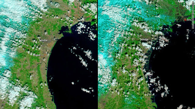
Currently, cesium and iodine are still being detected 40 km offshore of the plant. Levels of cesium higher than the safety standard have been found in bamboo shoots, shiitake mushrooms and mountain vegetables. (This article was written by Hisae Sato and Fumikazu Asai.)
http://www.nytimes.com/2011/05/02/world/asia/02japan.html?ref=world
People outside evacuation zones are being exposed to radiation levels several times more than normal.[/b][/size]National Police Agency chief Takaharu Ando, center, in protective gear in Futaba, a town now almost deserted after a 12-mile evacuation zone was declared in northeastern Japan.
https://www.youtube.com/watch?v=wKrpw5OmyGc
4/14/2011 -- VERY IMPORTANT -- Updates on Fukushima -- Fairewinds Associates, Inc
4/13/2011 -- URGENT - USA / Canada HIGH-mid levels of Cesium - Radiation and Jetstream Forecast

Another 7.2 - April 13, 2011
Nuclear explosion at Japan's Fukushima plant.
Second steam explosion at Japan's Fukushima nuclear plant.
U.N. demands Japan evacuate entire country immediately.
Tokyo receiving strong nuclear contamination winds from Fukushima nuclear disaster.
Intel shutting all operations in Japan.
Google closing Japan headquarters due to deadly nuclear contamination.
California milk recall due to deadly nuclear fallout contamination.
Apple recalling iPhones and iPads due to Japanese nuclear fallout contaminated parts.
Another major steam explosion at Japan's Fukushima nuclear plant, wind blowing straight toward Tokyo
Dead bodies loaded with nuclear fallout contamination washing ashore in Japan.
GM, Ford, Chrsler halt imports from Japan due to extreme levels of nuclear fallout on parts.
Circuit boards coming from Japan loaded with nuclear fallout contamination.
Japanese silicon imports cancelled by Apple, Microsoft, Qualcomm, Intel, Cisco, Applied Materials, et al
Full blown nuclear radiation sickness cases in Tokyo and Nagoya, Japan
Homeland Security considering banning all imports from Japan AND passenger flights as well
White House considering banning all Japanese imports due to nuclear fallout contamination.
Hundreds of thousands of Japanese vomiting from nuclear fallout contamination.
Japan silicon exports to be halted immediately, due to nuclear fallout contamination.
Japan's water and milk full of radiation, mass hysteria overtaking recent calmness.
Japan's Fukushima nuclear workers admit they are dying.
http://twitter.com/ChaminadeTrader

Japan’s nightmare: 823 quakes after 9.0 and still shaking

GoogleEarth Based 3D Map Of Real-Time Radioactivity Distribution In Japan; Projected Global Radioactivity Dispersion
http://www.blacklistednews.com/GoogleEarth_Based_3D_Map_Of_Real-Time_Radioactivity_Distribution_In_Japan%3B_Projected_Global_Radioactivity_Dispersion_/13240/0/6/6/Y/M.html
https://www.youtube.com/watch?v=hfqQCn-e2uU
Tokyo is evacuating - someone from Tokyo... heartbreaking
US Radiation Levels: http://www.radiationnetwork.com/
Quake moved Japan coast 8 feet, shifted Earth's axis
http://www.cnn.com/2011/WORLD/asiapcf/03/12/japan.earthquake.tsunami.earth/index.html?hpt=T1#
PHOTOS: http://www.dailymail.co.uk/news/article-1365318/Japan-earthquake-tsunami-The-moment-mother-nature-engulfed-nation.html
UGRADED to 9.1 2011/03/11 NEAR THE EAST COAST OF HONSHU, JAPAN
Quake moved Japan coast 8 feet; shifted Earth's axis
http://www.cnn.com/2011/WORLD/asiapcf/03/12/japan.earthquake.tsunami.earth/index.html?hpt=T1#
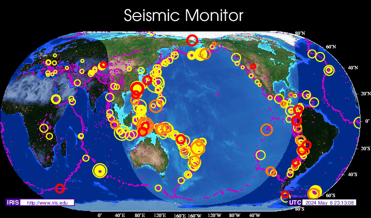
Seismic tension still primed in the Ring of Fire
Magnitude 7.2 - NEAR THE EAST COAST OF HONSHU, JAPAN
2011 March 09 02 UTC
Japanese officials said they were still assessing the situation and telling residents along the coast to stay away from the shore.
The meteorological agency said the quake hit at 11:45 a.m. local time Wednesday and was centered about 90 miles (150 kilometers) off the northeastern coast — about 270 miles (440 kilometers) northeast of Tokyo — at a depth of about 6.2 miles (10 kilometers).
A 24-inch (60-centimeter) tsunami reached the coastal town of Ofunato, in Iwate prefecture, shortly after noon. The meteorological agency warned that a tsunami of about 20 inches (50 centimeters) would hit the coast.
The Pacific Tsunami Warning Center in Hawaii said a Pacific-wide tsunami was not expected.
"We have confirmed that small tsunami have come up on the shores, but we have no reports of damage at this point," said Shinobu Nagano, an emergency and disaster response official in Iwate prefecture. "We are still trying to determine the impact of the quake."
Some train lines in the area were temporarily stopped after the quake, but they were restarted shortly after noon.
There was a 6.3 magnitude aftershock shortly after the main quake, the meteorological agency said.
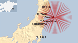
The U.S. Geological Survey said the 7.2-magnitude quake struck 8.8 miles (14.1 kilometers) underground, some 104 miles (168 kilometers) east of the closest major city of Sendai. The two agencies often have slightly different numbers.
Japan lies on the "Ring of Fire" — an arc of earthquake and volcanic zones that stretches around the Pacific Rim and where about 90 percent of the world's quakes occur.
http://www.katu.com/news/117623863.html
Earthquake Details
This event has been reviewed by a seismologist.
Magnitude
7.2
Date-Time
Wednesday, March 09, 2011 at 02:45:18 UTC
Wednesday, March 09, 2011 at 11:45:18 AM at epicenter
Time of Earthquake in other Time Zones
Location
38.510°N, 142.792°E
Depth
14.1 km (8.8 miles)
Region
NEAR THE EAST COAST OF HONSHU, JAPAN
Distances
168 km (104 miles) E of Sendai, Honshu, Japan
193 km (119 miles) SE of Morioka, Honshu, Japan
216 km (134 miles) E of Yamagata, Honshu, Japan
413 km (256 miles) NE of TOKYO, Japan
Location Uncertainty
horizontal +/- 12.8 km (8.0 miles); depth +/- 1.8 km (1.1 miles)
Parameters
NST=464, Nph=469, Dmin=390.7 km, Rmss=1.06 sec, Gp= 29°,
M-type="moment" magnitude from initial P wave (tsuboi method) (Mi/Mwp), Version=B
Source
USGS NEIC (WDCS-D)
Event ID
usb0001r57
http://earthquake.usgs.gov/earthquakes/recenteqsww/Quakes/usb0001r57.html
Tsunami Watch http://www.weather.gov/ptwc/?region=3

A strong earthquake has occurred, but a tsunami IS NOT expected along the California, Oregon, Washington, British Columbia, or Alaska coast. NO tsunami warning, watch or advisory is in effect for these areas. Based on the earthquake magnitude, location and historic tsunami records, a damaging tsunami IS NOT expected along the California, Oregon, Washington, British Columbia, and Alaska coasts. At coastal locations which have experienced strong ground shaking, local tsunamis are possible due to underwater landslides.
Update time = Wed Mar 9 4:50:17 UTC 2011 http://www.katu.com/news/117623863.html
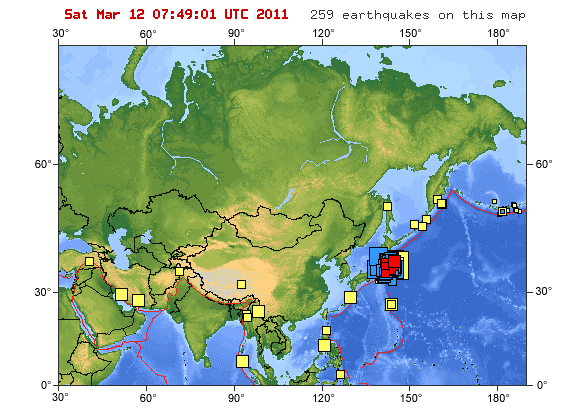
MAG UTC DATE-TIME y/m/d h:m:s LAT deg LON deg DEPTH km Region
MAP 5.7 2011/03/09 04:37:04 38.666 142.991 25.5 NEAR THE EAST COAST OF HONSHU, JAPAN
MAP 5.2 2011/03/09 04:32:10 38.727 143.001 32.1 OFF THE EAST COAST OF HONSHU, JAPAN
MAP 3.1 2011/03/09 04:17:17 34.280 -116.837 6.0 SOUTHERN CALIFORNIA
MAP 4.8 2011/03/09 04:15:39 38.857 142.658 12.6 NEAR THE EAST COAST OF HONSHU, JAPAN
MAP 5.2 2011/03/09 04:05:54 38.870 142.420 10.9 NEAR THE EAST COAST OF HONSHU, JAPAN
MAP 5.0 2011/03/09 03:19:00 38.795 142.962 19.9 NEAR THE EAST COAST OF HONSHU, JAPAN
MAP 5.2 2011/03/09 03:08:36 38.339 143.097 24.4 OFF THE EAST COAST OF HONSHU, JAPAN
MAP 5.6 2011/03/09 02:57:17 38.402 142.825 17.5 NEAR THE EAST COAST OF HONSHU, JAPAN
MAP 7.2 2011/03/09 02:45:18 38.510 142.792 14.1 NEAR THE EAST COAST OF HONSHU, JAPAN
MAP 4.6 2011/03/09 01:47:47 52.893 160.683 25.0 OFF THE EAST COAST OF KAMCHATKA, RUSSIA
MAP 4.7 2011/03/09 01:30:27 -19.410 171.907 19.3 VANUATU REGION
DATE and TIME (UTC) LAT LONG MAG DEPTH km REGION
08-MAR-2011 07:29:53 44.15 -129.47 4.6 10.3 OFF COAST OF OREGON
08-MAR-2011 07:19:33 44.33 -129.25 4.4 10.3 OFF COAST OF OREGON
08-MAR-2011 01:26:59 44.25 -129.39 5.0 17.8 OFF COAST OF OREGON
07-MAR-2011 15:59:27 44.45 -129.05 4.1 10.0 OFF COAST OF OREGON
06-MAR-2011 22:23:15 44.33 -129.47 4.9 10.2 OFF COAST OF OREGON
06-MAR-2011 21:35:47 44.37 -129.35 4.8 10.9 OFF COAST OF OREGON
06-MAR-2011 13:46:35 40.46 -125.43 4.6 2.6 OFF COAST OF NORTHERN CALIFORNIA
03-MAR-2011 03:55:05 50.42 -129.91 4.0 10.0 VANCOUVER ISLAND REGION
01-MAR-2011 02:19:46 38.81 -122.82 4.5 2.6 NORTHERN CALIFORNIA
23-FEB-2011 04:50:14 39.49 -122.96 4.0 11.3 NORTHERN CALIFORNIA
23-FEB-2011 04:49:41 39.50 -122.95 4.3 14.6 NORTHERN CALIFORNIA
FEMA urges all Americans to prepare for earthquakes or other disasters... LOS ANGELES 'BIG ONE' COULD COME SOONER THAN EXPECTED: STUDY... Southern California faults are feeling the pressure... US west coast at risk of “mega-quake”... San Andreas-Like Fault Found in Eastern U.S...Odds 1-in-3 for Northwest Mega-Quake Within 50 Years... Planet X approaching consequences. Evacuations: Gulf of Mexico Earthquake, Islands will be arising... Australian Survey Buoy Anomalies Offer New Evidence That Planet X is Approaching From the South:
http://cristiannegureanu.blogspot.com/2010/12/fema-urges-all-americans-to-prepare-for.html
Last edited by Carol on Fri Aug 19, 2011 9:20 pm; edited 34 times in total