 Carol Thu Mar 17, 2011 9:22 pm
 Turbulent skies- storms stir in both oceans
March 17, 2011 – MADAGASCAR – While a new storm has formed in the Pacific, an unsual weather band has erupted in the Atlantic Ocean. NASA’s Aqua and TRMM satellites are providing data to scientists about the Southern Atlantic Ocean Sub-tropical Storm Arani, a rare occurrence in the southern ocean. Rainfall data and cloud top temperatures revealed some heavy rain and strong thunderstorms exist in Arani as it continues to pull away from Brazil. NOAA’s Satellite and Information Service classified Arani as a T1 on the Dvorak intensity scale which would indicate an estimated wind speed of about 29 knots (~33 mph).
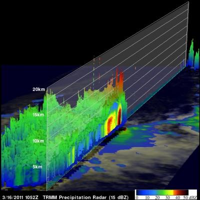
Arani has the appearance of a tropical cyclone but has been classified as a subtropical cyclone. Subtropical cyclones are low pressure areas that develop with a cold core and transition to a warm core in the mid-levels of the troposphere, resembling a tropical cyclone. They more typically form outside of hurricane season (which is June 1 to Nov. 30 in the Northern Atlantic, for example). They also have broad wind patterns and that means that their maximum sustained winds are usually located farther from the center than a tropical cyclone. They also have no weather fronts linked to them, such as a typical low pressure area that brings summertime storms with an associated cold front. Subtropical cyclones can sometimes become tropical cyclones, and occasionally, tropical cyclones can become subtropical. Tropical cyclones are very rare in the Southern Atlantic Ocean. In 2004 a cyclone called Catarina formed in the South Atlantic and caused some controversy when it was classified as a hurricane by the United States’ National Hurricane Center. Arani is over the open waters of the Southern Atlantic and continues to move east-southeast and farther away from Brazil. -Escience
http://esciencenews.com/articles/2011/03/16/nasa.satellites.show.towering.thunderstorms.rare.sub.tropical.storm.araniPosted in Earth Changes,
http://www.nasa.gov/centers/goddard/home/index.html


