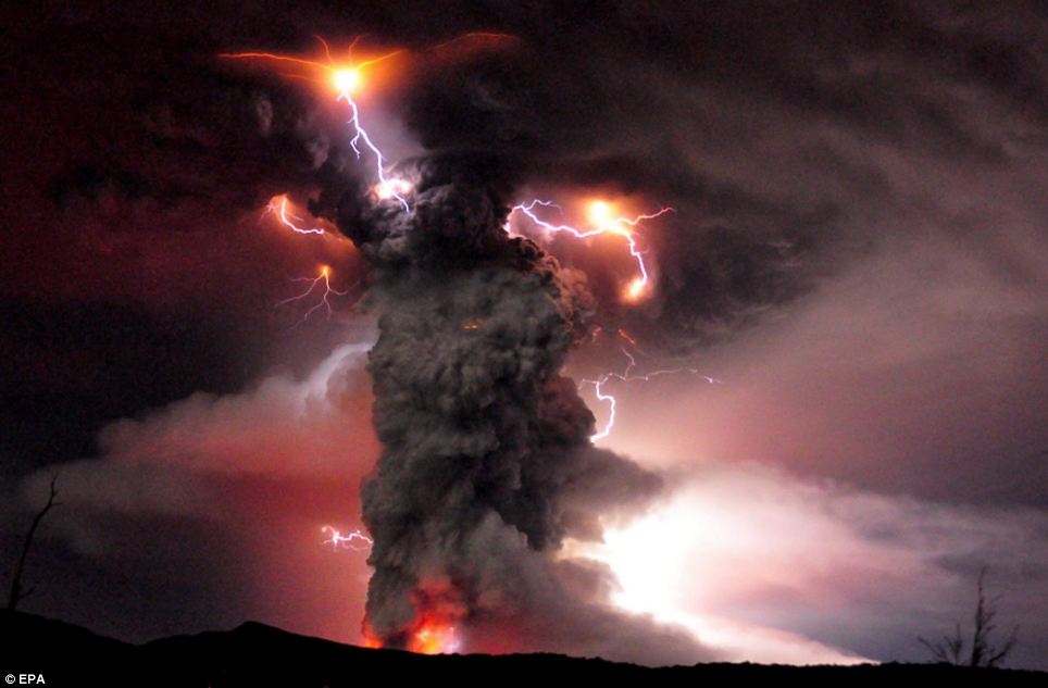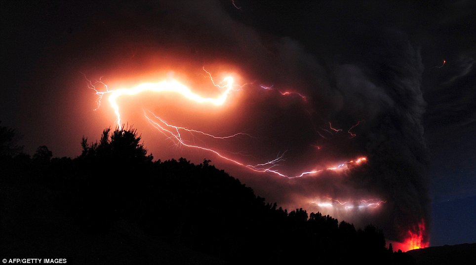

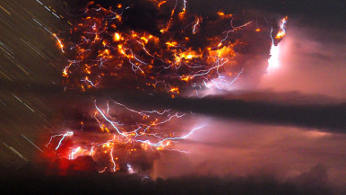
Lightning eerily dances through a massive six-mile-high ash cloud in southern Chile, grounding flights in the region.
Thousands Evacuate In Wake Of Chilean Volcano / South Chile volcano eruption prompts evacuation;
covers Argentine province with ash
"We are taking all necessary precautions," said Chilean Interior Minister Rodrigo Hinzpeter, announcing the government's evacuation orders.
An explosion in the Puyehue-Cordon Caulle volcanic complex sent plumes of smoke more than six miles into the air, the state emergency office said.
There were no immediate reports of injuries.
Video from the area showed white smoke drifting against an otherwise bright blue sky.
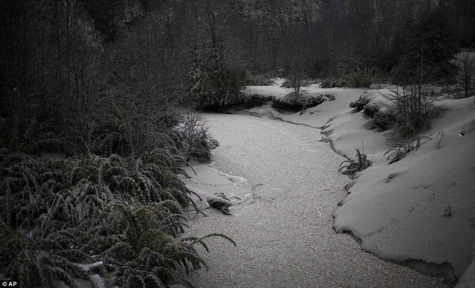
Hinzpeter said ash from the eruption could spread quickly with the wind and warned it had already reached parts of neighboring Argentina.
Chile is located on the so-called "Ring of Fire," an arc of volcanoes and fault lines circling the Pacific Basin that is prone to frequent earthquakes and volcanic eruptions.
http://www.ktvu.com/news/28132738/detail.html[left]
_______________________
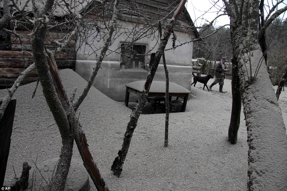
Southern Chile's Puyehue volcano erupted on Saturday for the first time in half a century prompting evacuation orders for 3,500 people and turning into dark the Argentine Patagonian resort of San Carlos de Bariloche, 100 kilometres to the east as it was covered with ash.
SNIP
Chile’s National Service of Geology and Mining said the explosion that sparked the eruption also produced a column of gas 10 kilometres high, hours after warning of strong seismic activity in the area.
”You can see the fire (in the volcano) and a plume of smoke, and there's a strong smell of sulphur,“ top Los Rios region official Juan Andres Varas told reporters.
The Chilean government ordered the evacuation of 3.500 peopleto be relocated to shelters in safe areas. Authorities issued a red alert, the maximum warning level, for the area. A border crossing between Argentina and Chile was closed.
In Argentina Bariloche authorities told the population to remain calm, to keep their water reserves at hand and to remain inside their homes at all times in order to avoid the falling ash. In case of an emergency, officials have suggested the use of face masks.
After a red alert was declared, Bariloche authorities shut down the airport. Firemen also asked the population to seal all windows and take their cars into their garages. The ash cloud is expected to expand all over the Patagonia Río Negro and Chubut provinces as prevailing winds blow the ashes east and south.
MORE: http://en.mercopress.com/2011/06/05/south-chile-volcano-eruption-prompts-evacuation-covers-argentine-province-with-ash
SOUTH AMERICA -
MAP 5.4 2011/06/05 10:25:17 -35.045 -71.697 45.5 MAULE, CHILE
MAP 2.5 2011/06/05 05:31:29 18.977 -65.015 26.0 VIRGIN ISLANDS REGION
MAP 3.4 2011/06/05 03:00:37 18.221 -68.695 128.6 DOMINICAN REPUBLIC
MAP 3.3 2011/06/05 02:22:03 19.568 -67.932 41.7 DOMINICAN REPUBLIC REGION
MAP 2.9 2011/06/04 23:19:23 18.974 -64.451 69.7 VIRGIN ISLANDS REGION
MAP 4.9 2011/06/04 17:54:09 -40.303 -71.698 20.7 LOS LAGOS, CHILE
MAP 4.7 2011/06/04 17:00:49 -40.443 -71.593 20.9 NEUQUEN, ARGENTINA
MAP 4.8 2011/06/04 16:28:49 -40.519 -71.791 19.6 NEUQUEN, ARGENTINA
MAP 4.6 2011/06/04 15:19:24 -40.460 -71.695 35.6 NEUQUEN, ARGENTINA
MAP 4.6 2011/06/04 15:05:47 -40.430 -71.673 46.2 NEUQUEN, ARGENTINA
MAP 4.7 2011/06/04 13:48:53 -40.340 -71.616 46.8 NEUQUEN, ARGENTINA
MAP 5.2 2011/06/04 13:37:43 -7.744 -74.312 139.7 NORTHERN PERU
MAP 4.7 2011/06/04 13:20:56 -40.358 -71.630 35.8 NEUQUEN, ARGENTINA
MAP 4.8 2011/06/04 12:23:59 -40.388 -71.428 58.9 NEUQUEN, ARGENTINA
MAP 3.0 2011/06/04 11:41:27 18.838 -68.191 97.0 DOMINICAN REPUBLIC REGION
MAP 3.3 2011/06/04 11:40:23 18.789 -68.170 101.0 DOMINICAN REPUBLIC REGION
MAP 3.4 2011/06/04 08:37:20 19.435 -64.848 85.0 VIRGIN ISLANDS REGION
MAP 4.5 2011/06/04 08:15:57 4.712 -82.500 10.3 SOUTH OF PANAMA
MAP 3.1 2011/06/04 06:17:40 19.536 -65.423 70.4 PUERTO RICO REGION
MAP 4.7 2011/06/04 06:12:09 -55.925 -27.964 118.9 SOUTH SANDWICH ISLANDS REGION
MAP 3.1 2011/06/04 05:55:32 19.081 -67.418 75.0 PUERTO RICO REGION
MAP 2.9 2011/06/03 23:58:14 18.780 -67.851 89.9 DOMINICAN REPUBLIC REGION
MAP 2.6 2011/06/03 23:03:21 18.670 -66.864 73.2 PUERTO RICO REGION
MAP 3.3 2011/06/03 22:40:19 18.469 -67.844 106.9 DOMINICAN REPUBLIC REGION
MAP 4.5 2011/06/03 19:20:13 14.243 -91.609 75.1 GUATEMALA
MAP 5.0 2011/06/03 14:36:56 -55.642 -25.437 54.0 SOUTH SANDWICH ISLANDS REGION
MAP 4.6 2011/06/03 14:21:25 17.966 -95.009 131.3 VERACRUZ, MEXICO
MAP 3.5 2011/06/03 10:26:50 18.785 -68.747 155.0 DOMINICAN REPUBLIC
MAP 3.2 2011/06/03 09:31:43 19.494 -68.005 93.8 DOMINICAN REPUBLIC REGION
MAP 3.4 2011/06/03 05:36:18 19.809 -63.589 67.1 NORTH OF THE VIRGIN ISLANDS
MAP 3.2 2011/06/03 05:34:53 19.192 -65.610 11.4 PUERTO RICO REGION
MAP 2.5 2011/06/03 04:48:26 19.756 -67.935 16.4 DOMINICAN REPUBLIC REGION
MAP 3.8 2011/06/03 04:26:37 19.700 -68.752 122.1 DOMINICAN REPUBLIC REGION
MAP 2.8 2011/06/03 03:39:23 18.969 -65.070 17.2 VIRGIN ISLANDS REGION
MAP 3.3 2011/06/03 03:28:16 19.652 -67.947 50.9 DOMINICAN REPUBLIC REGION
MAP 3.4 2011/06/03 03:18:32 19.582 -67.978 79.3 DOMINICAN REPUBLIC REGION
MAP 3.0 2011/06/03 03:11:56 19.287 -64.583 33.0 VIRGIN ISLANDS REGION
MAP 3.0 2011/06/03 00:33:46 17.551 -65.928 1.8 PUERTO RICO REGION
MAP 2.9 2011/06/03 00:16:48 19.202 -66.989 41.6 PUERTO RICO REGION
MAP 2.9 2011/06/02 23:50:39 19.024 -67.569 60.8 PUERTO RICO REGION
MAP 3.5 2011/06/02 23:08:57 19.773 -68.399 137.1 DOMINICAN REPUBLIC REGION
MAP 3.6 2011/06/02 20:19:17 19.737 -65.840 156.8 PUERTO RICO REGION
MAP 2.6 2011/06/02 18:11:08 19.080 -68.120 43.1 DOMINICAN REPUBLIC REGION
MAP 2.6 2011/06/02 17:36:20 17.884 -65.561 21.6 PUERTO RICO REGION
MAP 3.0 2011/06/02 17:22:44 18.949 -65.668 15.1 PUERTO RICO REGION
MAP 3.1 2011/06/02 13:50:55 19.183 -67.367 13.3 PUERTO RICO REGION
MAP 2.9 2011/06/02 10:11:07 18.535 -65.111 20.0 VIRGIN ISLANDS REGION
MAP 3.0 2011/06/02 03:52:21 18.688 -68.055 24.1 DOMINICAN REPUBLIC REGION
MAP 5.0 2011/06/01 22:58:01 4.766 -75.821 78.4 COLOMBIA
MAP 3.0 2011/06/01 17:54:57 19.135 -67.424 63.7 PUERTO RICO REGION
MAP 3.7 2011/06/01 16:58:06 18.882 -68.275 118.5 DOMINICAN REPUBLIC REGION
MAP 3.5 2011/06/01 16:29:49 19.119 -64.563 56.0 VIRGIN ISLANDS REGION
MAP 5.1 2011/06/01 13:47:29 -37.460 -73.665 26.9 OFFSHORE BIO-BIO, CHILE
MAP 6.2 2011/06/01 12:55:21 -37.545 -73.663 15.1 OFFSHORE BIO-BIO, CHILE
MAP 2.9 2011/06/01 11:57:17 18.681 -63.857 46.2 VIRGIN ISLANDS REGION
MAP 2.8 2011/06/01 11:53:17 19.047 -64.126 49.7 VIRGIN ISLANDS REGION
MAP 4.4 2011/06/01 11:14:54 -43.115 -71.751 179.2 CHUBUT, ARGENTINA
MAP 4.0 2011/06/01 03:46:43 19.392 -68.898 95.3 DOMINICAN REPUBLIC REGION
MAP 4.3 2011/06/01 02:27:18 14.363 -90.825 111.5 GUATEMALA
MAP 3.2 2011/05/31 22:25:26 19.497 -67.702 54.6 PUERTO RICO REGION
MAP 3.3 2011/05/31 13:16:24 19.948 -66.453 50.5 PUERTO RICO REGION
MAP 3.0 2011/05/31 12:34:41 19.083 -67.840 32.9 DOMINICAN REPUBLIC REGION
MAP 2.9 2011/05/31 09:22:27 17.912 -65.450 19.9 PUERTO RICO REGION
MAP 4.0 2011/05/31 08:45:43 15.229 -97.289 25.1 OFFSHORE OAXACA, MEXICO
MAP 3.4 2011/05/31 06:34:59 19.335 -67.806 83.1 DOMINICAN REPUBLIC REGION
MAP 2.9 2011/05/31 02:21:52 18.084 -67.821 117.0 MONA PASSAGE, PUERTO RICO
MAP 3.0 2011/05/31 00:55:18 18.829 -64.995 3.7 VIRGIN ISLANDS REGION
MAP 2.8 2011/05/31 00:34:40 17.928 -65.439 18.0 PUERTO RICO REGION
MAP 2.5 2011/05/30 23:33:23 17.945 -65.449 18.1 PUERTO RICO REGION
MAP 2.8 2011/05/30 23:23:50 18.017 -65.974 19.0 PUERTO RICO
MAP 2.5 2011/05/30 23:12:24 17.929 -65.440 16.6 PUERTO RICO REGION
MAP 4.8 2011/05/30 17:28:46 -19.844 -66.839 241.2 POTOSI, BOLIVIA
MAP 3.3 2011/05/30 12:28:46 19.272 -68.255 7.4 DOMINICAN REPUBLIC REGION
MAP 4.5 2011/05/30 10:48:07 -24.244 -67.064 156.2 SALTA, ARGENTINA
MAP 2.9 2011/05/30 09:14:51 19.141 -67.442 58.3 PUERTO RICO REGION
MAP 2.9 2011/05/30 03:37:34 18.808 -68.407 76.1 DOMINICAN REPUBLIC REGION
MAP 3.1 2011/05/30 01:16:13 19.315 -68.366 10.0 DOMINICAN REPUBLIC REGION
MAP 3.3 2011/05/29 20:47:16 19.357 -64.320 12.3 VIRGIN ISLANDS REGION
MAP 3.1 2011/05/29 16:40:06 18.566 -64.429 53.7 VIRGIN ISLANDS REGION