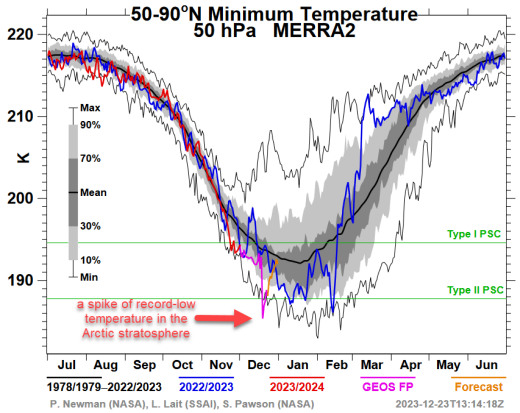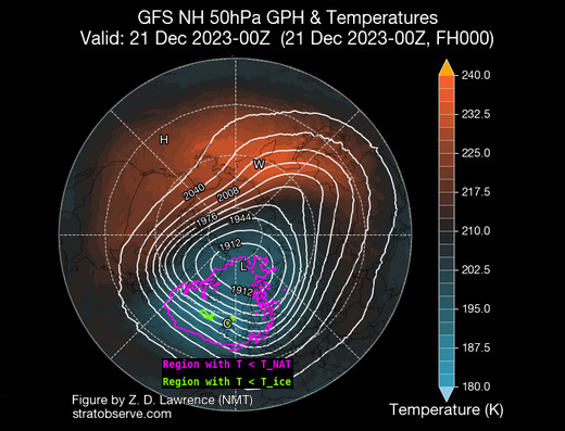
POLAR STRATOSPHERIC CLOUDS
COMING SOON--AN EARTH-DIRECTED FLARE: Now turning to face Earth, sunspot AR3529 is growing rapidly (movie), and it has a 'beta-gamma' magnetic field that poses a threat for strong M-class solar flares. Geoeffective explosions are likely this week.
POLAR STRATOSPHERIC CLOUDS: polar stratospheric clouds (PSCs) are rare.
==
Strong M6.2 earthquake hits southern Peru - Wednesday, December 20, 2023
https://watchers.news/2023/12/20/strong-m6-2-earthquake-hits-southern-peru/
71 000 people are estimated to have felt moderate shaking and 2 023 000 light. The USGS issued a Green alert for shaking-related fatalities and economic losses. There is a low likelihood of casualties and damage. Recent earthquakes in this area have caused secondary hazards such as landslides that might have contributed to losses.
==
Volcanic eruption starts near Grindavik, Reykjanes Peninsula, Iceland - Tuesday, December 19, 2023
https://watchers.news/2023/12/19/volcanic-eruption-starts-near-grindavik-reykjanes-peninsula-iceland/
A new volcanic fissure eruption started at 22:17 UTC on December 18, 2023, about 4 km (2.5 miles) NE of the town of Grindavik, Reykjanes, Iceland. The eruptive fissure is about 4 km long, with the northern end just east of Stóra-Skógfell and the southern end just east of Sundhnúk. The eruption was preceded by an earthquake swarm that started at 21:00 UTC.
According to the aerial observations performed by 02:10 UTC on December 19 as well as seismicity, the eruption fissure is expanding to the south. At the time, the southern end of the fissure was close to Sundhnúkur. Officials are warning this new eruption is not tourist-friendly and seems to be significantly larger than the Fagradalsfjall in 2021.
The eruptive fissure is currently about 4 km (2.5 miles) long, with the northern end just east of Stóra-Skógfell and the southern end just east of Sundhnúk. The distance from the southern end to the edge of Grindavík is almost 3 km (1.8 miles).
==
Rare snowfall hits southern China as north endures deep freeze - Wednesday, December 20, 2023
https://watchers.news/2023/12/20/rare-snowfall-hits-southern-china-as-north-endures-deep-freeze/
China is currently undergoing a wave of cold weather, bringing rare snowfall to areas as far south as Guangdong province. Meanwhile, the northern parts of the country are experiencing near-historic low temperatures. In the north, temperatures have dipped below zero, affecting transportation and causing issues such as a brake failure on a Beijing commuter train. Despite early predictions of a warmer winter due to El Niño, the reality has been a week of frigid weather following one of the warmest Octobers in decades. Guangdong, typically seeing limited snowfall, experienced a snowy mountain top just 80 km (50 miles) north of Guangzhou. The region, usually enjoying double-digit temperatures in early winter, is now facing a low of 8 °C (46 °F).
==
Strong and shallow M6.2 earthquake hits Gansu-Qinghai border region, China - December 18, 2023
https://watchers.news/2023/12/18/strong-and-shallow-m6-0-earthquake-hits-gansu-qinghai-border-region-china/
==
NWS warns of excessive rainfall in California - Wednesday, December 20, 2023 The National Weather Service warns of a Moderate Risk of excessive rainfall in Southern California, with potential flash flooding and mudflows, as a series of storms approach the state.
https://watchers.news/2023/12/20/nws-warns-of-excessive-rainfall-in-california/
==
Flood emergency: Thousands urged to evacuate in Queensland amid severe floods, Australia - December 17, 2023
https://watchers.news/2023/12/17/flood-emergency-thousands-urged-to-evacuate-in-queensland-amid-severe-floods-australia/
==
Record rainfall and major flooding hit Carolinas as storm moves up East Coast - December 18, 2023
The storm, which brought tropical-storm-like conditions to Florida on Saturday, December 16, caused flash flood emergencies along the South Carolina coast on Sunday. The system intensified as it moved northeastward, posing threats of flooding, high winds, and severe weather that could disrupt travel plans in the Northeast, mid-Atlantic, and Southeast.
https://watchers.news/2023/12/18/record-rainfall-and-major-flooding-hit-carolinas-as-storm-moves-up-east-coast/
==
Deadly floods and landslides strike West Sumatra, lahar warnings issued, Indonesia - Wednesday, December 20, 2023
https://watchers.news/2023/12/20/deadly-floods-and-landslides-strike-west-sumatra-lahar-warnings-issued-indonesia/
Two people have died in West Sumatra, Indonesia, due to a landslide in Agam regency, with floods and landslides affecting other areas, including Lima Puluh Kota. Officials are urging residents living near Marapi volcano to be vigilant of potential cold lava flows (lahars).
This concern stems from Mount Marapi’s significant eruption on December 3, 2023, which claimed the lives of 23 climbers. The sudden eruption ejected volcanic ash up to 15 km (50,000 feet) into the air and generated a pyroclastic flow extending 3 km (1.8 miles) on the northern slope. The aftermath left climbers stranded and nearby villages covered in volcanic debris.
==
Extremely heavy monsoon rains in Tamil Nadu lead to fatal flooding, significant livestock losses, India - December 20, 2023 This monsoon season has seen Thirunelveli district receiving 760 mm (29.9 inches) of rainfall, 61 percent above the normal level, while Thoothukudi recorded normal rainfall of 349 mm (13.7 inches) since October.
https://watchers.news/2023/12/20/extremely-heavy-monsoon-rains-in-tamil-nadu-lead-to-fatal-flooding-significant-livestock-losses-india/
==
Small explosion at Kanaga volcano, Aviation Color Code raised to Yellow, Alaska - December 19, 2023
The event was detected in local infrasound and seismic data and was followed by elevated earthquake seismicity that is ongoing. No ash emissions have been observed in partly cloudy satellite images. The last eruption of this volcano took place on February 18, 2012 (VEI 2).
https://watchers.news/2023/12/19/small-explosion-at-kanaga-volcano-aviation-color-code-raised-to-yellow-alaska/
==
Severe soil liquefaction hits Minhe County after M6.2 earthquake in Gansu, China - December 19, 2023
https://watchers.news/2023/12/19/severe-soil-liquefaction-hits-minhe-county-after-m6-2-earthquake-in-gansu-china/
According to reports, half of one village in Minhe County was engulfed in mud, killing 19 people. The village is located about 10 km (6.2 miles) from the epicenter of the M6.2 earthquake that hit at 15:59 UTC (23:59 local time) on December 18. As of 18:00 UTC on December 19, the earthquake’s death toll has exceeded 120, with over 700 people injured. Authorities expect fatalities to rise as the extent of the damage becomes clearer. Over 5 000 buildings have been impacted by the quake, many of which were struck by subsequent mudslides, and numerous roads have suffered damage due to landslides