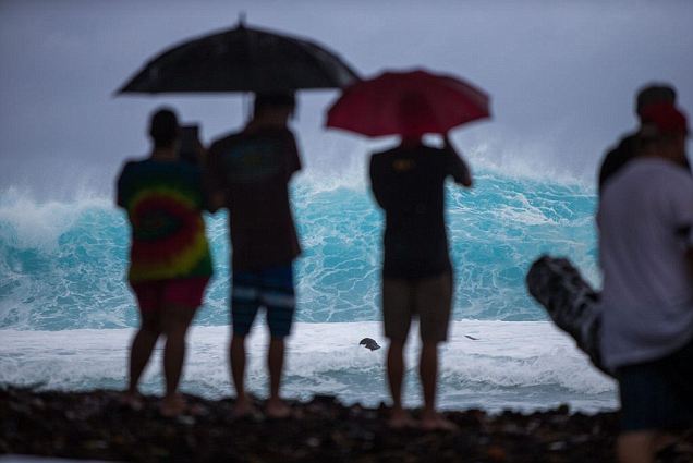
Hurricane Iselle is tracking toward Hawaii for the latter end of the week bringing a high risk of heavy rain, damaging winds and rough seas to the southern part of the island chain, namely the Big Island.
A second hurricane, Julio, also bears watching.
If Iselle makes landfall on the Big Island of Hawaii as a hurricane, it would be the first hurricane ever to do so since records began in 1950.
AccuWeather meteorologists expect Iselle to make landfall over the Big Island (Hawaii) early Friday morning, local time, with sustained winds between 70 and 80 mph and higher gusts. Building seas will precede the storm during the day Thursday. Gusty squalls will arrive Thursday evening.
However, even as a strong tropical storm or minimal hurricane, Iselle will still pack a punch. AccuWeather Senior Meteorologist Mark Mancuso has all of the details in the video below. Heavy rain, strong winds and building seas and surf will affect the islands Thursday into Friday.
Friday will bring the worst impacts from Iselle on the islands as a whole.
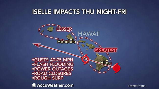
AccuWeather.com meteorologists are concerned for significant flash flooding, damaging wind gusts, mudslides and other debris flows. Ground access and communication to some communities could be cut off.
"Tropical storm-force winds will cause at least scattered power failures on the islands, including in the City of Honolulu," said Mike Smith, senior vice president of AccuWeather Enterprise Solutions.
Smith stated that based on the current forecast path and strength of Iselle, lengthy power outages are possible on the Big Island (Hawaii).
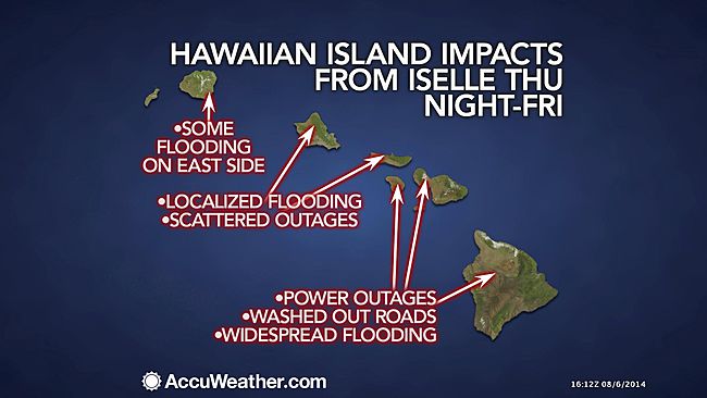
"Multiple roads could be washed out on the Big Island, Oahu and Lanai," Smith said.
Rainfall will average 2 to 4 inches over the islands with locally higher amounts, especially on the eastern and northern slopes of the islands, particularly on the Big Island. These slopes could receive locally 8- to 12-inch rainfall.
Bathers, boarders and boaters should exercise extreme caution, even as the system weakens while approaching the islands. Small craft should remain in port as waves in unprotected waters will range between 15 and 25 feet.
According to AccuWeather Hurricane Expert Dan Kottlowski, "Wave action along the eastern and northern coastline of the islands, especially on the Big Island can lead to damage from flooding and erosion."
"However, as Iselle continues to track toward the west, a southwest flow may bring higher than normal surf to west- and south-facing coastal areas, as well as significant rainfall on the south-facing slopes of the mountains."
Visitors and residents alike should check the conditions throughout the week as the approaching storm may cause rough surf and rip currents.
RELATED:
AccuWeather.com Hurricane Center: Track, Official Advisories
INFOGRAPHIC: Iselle Threatens Hawaii
How Common are Hurricanes in Hawaii?
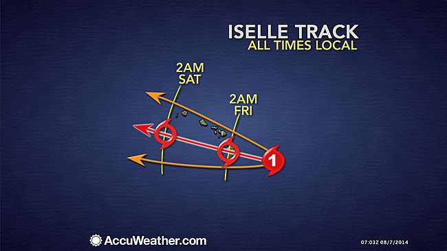
The Big Island of Hawaii will be the first to feel the impacts from Iselle as the center of the storm is forecast to reach the island Thursday evening, local time.
At present track, the Big Island of Hawaii will take a direct hit from the storm before passing just south of the smaller islands, such as Maui or Oahu.
Due to the projected track of the storm, areas on the northern and eastern portions of the islands will likely feel greater effects than the southern and western sides.
However, if the projected path of the storm shifts, so would the areas expected to feel the highest impacts.
Some portions of the islands that typically receive little rainfall could be hit with flash flooding.
A direct hit on the islands does not have to occur for significant impact as the storm is much larger than a single point of latitude and longitude.
The tropical threat for Hawaii will not end with Iselle. There is the potential for impacts from a second tropical system to hit two to three days later. Julio could bring another round of pounding waves, localized flooding rain and strong winds.
Hurricane Julio is also churning over the eastern Pacific and is forecast to track toward the Hawaiian Islands right on the heels of Iselle, but on a slightly different trajectory that would take the system farther north.
AccuWeather meteorologists believe that this storm will approach the chain of islands late in the weekend or early next week. However, the exact track that it will take remains uncertain.
According to Meteorologist Mark Mancuso, "Julio will be passing over waters churned up and cooled by Iselle, which argues for weakening after initial strengthening."
Here are some precautions that Smith recommends Hawaiians should take in preparation for Iselle and Julio:
A second hurricane, Julio, also bears watching.
If Iselle makes landfall on the Big Island of Hawaii as a hurricane, it would be the first hurricane ever to do so since records began in 1950.
AccuWeather meteorologists expect Iselle to make landfall over the Big Island (Hawaii) early Friday morning, local time, with sustained winds between 70 and 80 mph and higher gusts. Building seas will precede the storm during the day Thursday. Gusty squalls will arrive Thursday evening.
However, even as a strong tropical storm or minimal hurricane, Iselle will still pack a punch. AccuWeather Senior Meteorologist Mark Mancuso has all of the details in the video below. Heavy rain, strong winds and building seas and surf will affect the islands Thursday into Friday.
Friday will bring the worst impacts from Iselle on the islands as a whole.

AccuWeather.com meteorologists are concerned for significant flash flooding, damaging wind gusts, mudslides and other debris flows. Ground access and communication to some communities could be cut off.
"Tropical storm-force winds will cause at least scattered power failures on the islands, including in the City of Honolulu," said Mike Smith, senior vice president of AccuWeather Enterprise Solutions.
Smith stated that based on the current forecast path and strength of Iselle, lengthy power outages are possible on the Big Island (Hawaii).

"Multiple roads could be washed out on the Big Island, Oahu and Lanai," Smith said.
Rainfall will average 2 to 4 inches over the islands with locally higher amounts, especially on the eastern and northern slopes of the islands, particularly on the Big Island. These slopes could receive locally 8- to 12-inch rainfall.
Bathers, boarders and boaters should exercise extreme caution, even as the system weakens while approaching the islands. Small craft should remain in port as waves in unprotected waters will range between 15 and 25 feet.
According to AccuWeather Hurricane Expert Dan Kottlowski, "Wave action along the eastern and northern coastline of the islands, especially on the Big Island can lead to damage from flooding and erosion."
"However, as Iselle continues to track toward the west, a southwest flow may bring higher than normal surf to west- and south-facing coastal areas, as well as significant rainfall on the south-facing slopes of the mountains."
Visitors and residents alike should check the conditions throughout the week as the approaching storm may cause rough surf and rip currents.

RELATED:
AccuWeather.com Hurricane Center: Track, Official Advisories
INFOGRAPHIC: Iselle Threatens Hawaii
How Common are Hurricanes in Hawaii?
The Big Island of Hawaii will be the first to feel the impacts from Iselle as the center of the storm is forecast to reach the island Thursday evening, local time.
At present track, the Big Island of Hawaii will take a direct hit from the storm before passing just south of the smaller islands, such as Maui or Oahu.
Due to the projected track of the storm, areas on the northern and eastern portions of the islands will likely feel greater effects than the southern and western sides.
However, if the projected path of the storm shifts, so would the areas expected to feel the highest impacts.
Some portions of the islands that typically receive little rainfall could be hit with flash flooding.
A direct hit on the islands does not have to occur for significant impact as the storm is much larger than a single point of latitude and longitude.
The tropical threat for Hawaii will not end with Iselle. There is the potential for impacts from a second tropical system to hit two to three days later. Julio could bring another round of pounding waves, localized flooding rain and strong winds.
Hurricane Julio is also churning over the eastern Pacific and is forecast to track toward the Hawaiian Islands right on the heels of Iselle, but on a slightly different trajectory that would take the system farther north.
AccuWeather meteorologists believe that this storm will approach the chain of islands late in the weekend or early next week. However, the exact track that it will take remains uncertain.
According to Meteorologist Mark Mancuso, "Julio will be passing over waters churned up and cooled by Iselle, which argues for weakening after initial strengthening."
Here are some precautions that Smith recommends Hawaiians should take in preparation for Iselle and Julio:




 Stay safe, Carol.