tMoA

Would you like to react to this message? Create an account in a few clicks or log in to continue.
tMoA

~ The only Home on the Web You'll ever need ~

3 posters

    Tilt: South Pacific seismic crisis moving towards geological catastrophism?

    Carol
    Carol
    Admin
    Admin


    Posts : 31721
    Join date : 2010-04-07
    Location : Hawaii

    Tilt: South Pacific seismic crisis moving towards geological catastrophism? Empty Tilt: South Pacific seismic crisis moving towards geological catastrophism?

    Post  Carol Sun Jul 10, 2011 10:12 am

    Tilt: South Pacific seismic crisis moving towards geological catastrophism? Km5
    Tilt: South Pacific seismic crisis moving towards geological catastrophism?
    July 9, 2011 – KERMADEC - The seismic crisis involving the convulsion of earthquakes along the trench underpinning the Pacific and Australian tectonic plates may be entering what appears to be a new phase of more aggressive geological activity. The spasm of new earthquakes have been of a strong 5+ magnitude range. The diffusion of earthquakes are moving further along the tectonic plate boundary line and we also have activity at another magma plume- Java. Double earthquakes have occurred in the Tonga region- a 5.8 and a 5.3. We’re also seeing an extension of this crisis with seismic activity reported as far away as the Mariana Islands and the New Ireland region of Papua New Guinea registering 4.9 and 4.6 earthquakes. It is only my assessment but I think New Zealanders should prepare for the potentiality of an increase in seismic events or possible tsunami threats starting with the North Island. What we’re seeing is more than typical aftershock patterns.

    Tilt: South Pacific seismic crisis moving towards geological catastrophism? Aus Tilt: South Pacific seismic crisis moving towards geological catastrophism? Nw-z
    Anomalistic triple seismic waves Australia (left) and stronger reading for New Zealand (right)

    Tilt: South Pacific seismic crisis moving towards geological catastrophism? Mi Tilt: South Pacific seismic crisis moving towards geological catastrophism? Ng
    Same pattern on seismograms under Mariana Islands (left) and Papua New Guinea (right)


    _________________
    What is life?
    It is the flash of a firefly in the night, the breath of a buffalo in the wintertime. It is the little shadow which runs across the grass and loses itself in the sunset.

    With deepest respect ~ Aloha & Mahalo, Carol
    Sanicle
    Sanicle


    Posts : 2228
    Join date : 2011-02-28
    Location : Melbourne, Australia

    Tilt: South Pacific seismic crisis moving towards geological catastrophism? Empty Re: Tilt: South Pacific seismic crisis moving towards geological catastrophism?

    Post  Sanicle Sun Jul 10, 2011 10:20 am

    Gee it really is all starting up again, isn't it, what with this and other posts you've made Carol.
    HigherLove
    HigherLove


    Posts : 2357
    Join date : 2011-01-27
    Age : 58

    Tilt: South Pacific seismic crisis moving towards geological catastrophism? Empty Re: Tilt: South Pacific seismic crisis moving towards geological catastrophism?

    Post  HigherLove Sun Jul 10, 2011 10:46 am

    MAP 5.1 2011/07/10 12:07:53 -32.828 -176.883 19.8 SOUTH OF THE KERMADEC ISLANDS
    MAP 4.4 2011/07/10 11:49:10 -15.787 -72.622 109.5 SOUTHERN PERU
    MAP 3.7 2011/07/10 10:27:18 19.438 -65.275 76.0 PUERTO RICO REGION
    MAP 5.4 2011/07/10 06:57:25 -32.390 -178.287 6.4 SOUTH OF THE KERMADEC ISLANDS

    http://earthquake.usgs.gov/earthquakes/recenteqsww/Quakes/quakes_all.php

    Just today, and this seems to be the new norm.
    HigherLove
    HigherLove


    Posts : 2357
    Join date : 2011-01-27
    Age : 58

    Tilt: South Pacific seismic crisis moving towards geological catastrophism? Empty Re: Tilt: South Pacific seismic crisis moving towards geological catastrophism?

    Post  HigherLove Sun Jul 10, 2011 10:48 am
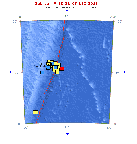
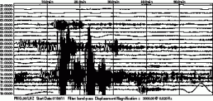
    Yesterday

    MAP 5.2 2011/07/09 23:49:06 -33.583 -178.725 20.3 SOUTH OF THE KERMADEC ISLANDS
    MAP 4.9 2011/07/09 23:47:30 -7.970 -13.468 10.0 ASCENSION ISLAND REGION
    MAP 3.0 2011/07/09 23:22:14 19.412 -155.606 3.0 ISLAND OF HAWAII, HAWAII
    MAP 4.9 2011/07/09 23:17:59 -7.911 -13.639 10.0 ASCENSION ISLAND REGION
    MAP 2.6 2011/07/09 23:15:10 61.321 -146.933 20.0 SOUTHERN ALASKA
    MAP 4.6 2011/07/09 22:44:45 5.784 126.064 137.1 MINDANAO, PHILIPPINES
    MAP 5.0 2011/07/09 22:21:05 -29.114 -177.163 20.1 KERMADEC ISLANDS, NEW ZEALAND
    MAP 2.9 2011/07/09 21:26:11 35.795 -120.353 10.7 CENTRAL CALIFORNIA
    MAP 4.7 2011/07/09 20:05:46 -24.058 -179.418 443.0 SOUTH OF THE FIJI ISLANDS
    MAP 2.6 2011/07/09 19:44:38 38.282 -119.099 5.0 CENTRAL CALIFORNIA
    MAP 5.7 2011/07/09 19:35:20 -29.359 -176.983 21.7 KERMADEC ISLANDS REGION
    MAP 5.1 2011/07/09 19:34:36 -29.345 -177.018 5.4 KERMADEC ISLANDS, NEW ZEALAND
    MAP 5.0 2011/07/09 19:02:56 -7.429 128.608 150.8 KEPULAUAN BARAT DAYA, INDONESIA
    MAP 5.1 2011/07/09 18:18:34 -29.513 -175.592 42.4 KERMADEC ISLANDS REGION
    MAP 5.2 2011/07/09 16:17:38 -29.336 -177.108 52.0 KERMADEC ISLANDS, NEW ZEALAND

    MAP 2.8 2011/07/09 16:05:00 36.870 -119.319 20.3 CENTRAL CALIFORNIA
    MAP 5.1 2011/07/09 15:25:38 -29.861 -177.794 23.4 KERMADEC ISLANDS, NEW ZEALAND
    MAP 5.8 2011/07/09 15:02:29 -29.327 -177.062 23.3 KERMADEC ISLANDS, NEW ZEALAND

    MAP 5.5 2011/07/09 14:40:46 -35.877 178.162 18.3 OFF EAST COAST OF THE NORTH ISLAND, N.Z.
    MAP 5.0 2011/07/09 14:12:24 -29.296 -177.172 58.4 KERMADEC ISLANDS, NEW ZEALAND
    MAP 4.9 2011/07/09 13:57:22 -7.375 128.815 146.5 KEPULAUAN BARAT DAYA, INDONESIA
    MAP 5.6 2011/07/09 13:54:20 -29.387 -177.124 19.4 KERMADEC ISLANDS, NEW ZEALAND
    MAP 4.8 2011/07/09 13:26:59 -8.974 108.428 36.8 JAVA, INDONESIA
    MAP 5.3 2011/07/09 12:54:23 -29.364 -176.287 20.4 KERMADEC ISLANDS REGION
    MAP 4.9 2011/07/09 12:42:32 16.222 -96.105 40.0 OAXACA, MEXICO
    MAP 4.9 2011/07/09 12:20:54 -29.544 -177.089 55.0 KERMADEC ISLANDS, NEW ZEALAND
    MAP 4.5 2011/07/09 11:44:11 -24.948 179.924 494.0 SOUTH OF THE FIJI ISLANDS
    MAP 4.3 2011/07/09 10:57:35 3.391 -75.936 180.7 COLOMBIA
    MAP 4.6 2011/07/09 10:01:09 -4.405 153.108 79.2 NEW IRELAND REGION, PAPUA NEW GUINEA
    MAP 4.9 2011/07/09 07:55:28 16.873 147.120 51.3 MARIANA ISLANDS REGION
    MAP 5.3 2011/07/09 07:08:21 -21.116 -174.640 23.7 TONGA
    MAP 5.8 2011/07/09 06:53:47 -21.217 -174.493 13.7 TONGA

    MAP 4.7 2011/07/09 06:00:06 -23.681 -66.876 196.1 JUJUY, ARGENTINA
    MAP 5.5 2011/07/09 05:51:38 -4.111 129.435 19.6 BANDA SEA
    MAP 4.7 2011/07/09 01:53:55 -29.062 -176.609 19.0 KERMADEC ISLANDS REGION
    MAP 3.9 2011/07/09 01:47:13 51.720 -171.643 25.6 FOX ISLANDS, ALEUTIAN ISLANDS, ALASKA
    MAP 4.6 2011/07/09 01:36:33 3.912 126.705 83.8 KEPULAUAN TALAUD, INDONESIA
    MAP 2.6 2011/07/09 01:03:44 41.654 -122.231 2.5 NORTHERN CALIFORNIA
    MAP 5.3 2011/07/09 00:53:17 -29.022 -176.686 19.6 KERMADEC ISLANDS REGION
    MAP 2.5 2011/07/09 00:10:38 18.882 -65.556 11.6 PUERTO RICO REGION


    Last edited by HigherLove on Sun Jul 10, 2011 11:17 am; edited 2 times in total (Reason for editing : The Tonga and Kermadec Trenches are subduction zones (Pacific Plate under Australian))
    HigherLove
    HigherLove


    Posts : 2357
    Join date : 2011-01-27
    Age : 58

    Tilt: South Pacific seismic crisis moving towards geological catastrophism? Empty Re: Tilt: South Pacific seismic crisis moving towards geological catastrophism?

    Post  HigherLove Sun Jul 10, 2011 10:57 am

    Boundaries of the Australian Plate

    The Australian plate is a product of the seafloor spreading-induced fragmentation of the ancient supercontinent Gondwana. The Australian plate used to be a part of the larger Indo-Australian plate. This plate contains the continents of Australia, New Zealand, Indonesia, and Papua New Guinea.

    The southeastern border of the Australian plate is a convergent boundary with the Pacific plate, although complexities occur near New Zealand. The Pacific plate subducts under the Australian plate to form the Tonga and Kermadec Trenches, and the parallel Tonga and Kermadec island arcs, north of New Zealand. New Zealand straddles this edge, and south of the North Island the tectonic boundary is a transform fault. In the central South Island plate motion is manifested as a predominantly strike-slip movement along the Alpine Fault. In the southwestern part of the South Island, relative plate motion is accommodated by oblique subduction of the Australian plate, and consequent deformation of the overriding Pacific plate inland of the trench, which has produced the Southern Alps of New Zealand.

    https://wiki.carleton.edu/display/tectonics/Australian+plate

    Tilt: South Pacific seismic crisis moving towards geological catastrophism? Austra10


    http://www.themistsofavalon.net/t2496p15-plate-tectonics-earth-s-lithospheric-plates


      Current date/time is Thu May 02, 2024 1:07 am